Bridge Statistics for Columbia, Pennsylvania (PA)
Condition, Traffic, Stress, Structural Evaluation, Project Costs
- National Bridge Inventory (NBI) Statistics
- 34Number of bridges
- 1,414ft / 431mTotal length
- $36,167,000Total costs
- 518,928Total average daily traffic
- 85,596Total average daily truck traffic
- National Bridge Inventory (NBI) Registered Bridges for Columbia
- No street view available for this location
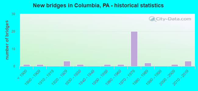
- New bridges - historical statistics
- 1Before 1900
- 11900-1909
- 31920-1929
- 11930-1939
- 11950-1959
- 11960-1969
- 201970-1979
- 21980-1989
- 12000-2009
- 32010-2019
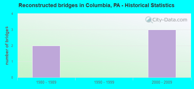
- Reconstructed bridges - Historical Statistics
- 21980-1989
- 01990-1999
- 32000-2009
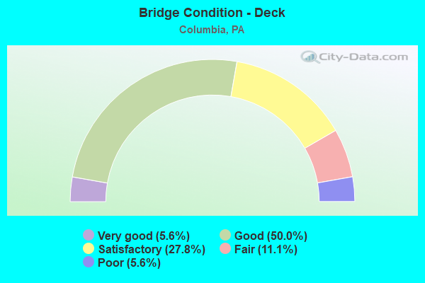
- Bridge Condition - Deck
- 5.6%Very good
- 50.0%Good
- 27.8%Satisfactory
- 11.1%Fair
- 5.6%Poor
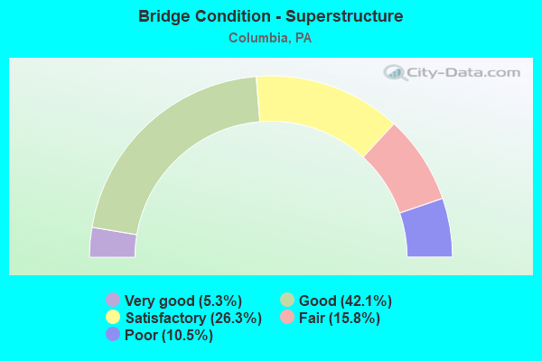
- Bridge Condition - Superstructure
- 5.3%Very good
- 42.1%Good
- 26.3%Satisfactory
- 15.8%Fair
- 10.5%Poor
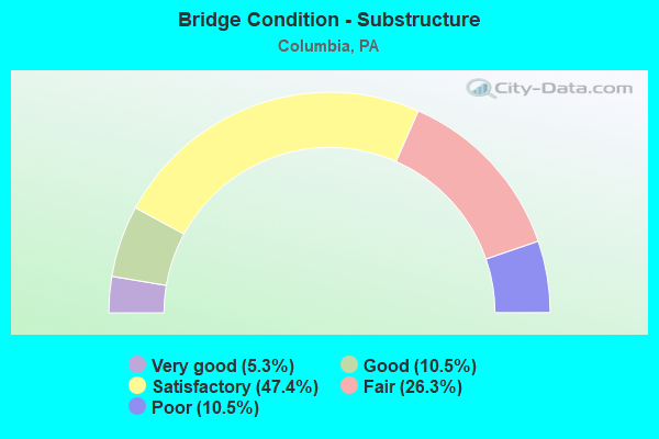
- Bridge Condition - Substructure
- 5.3%Very good
- 10.5%Good
- 47.4%Satisfactory
- 26.3%Fair
- 10.5%Poor
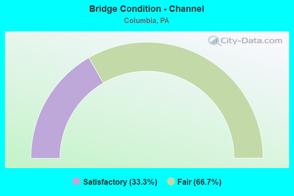
- Bridge Condition - Channel
- 33.3%Satisfactory
- 66.7%Fair
Find on map >> Show street view
Structure Number: 21, Location: NEAR CCAC BOYCE CAMPUS (Lat: 40.451906, Lng: -79.754253), Route carried "on" structure: Interstate 76, Year Built: 1952, Year Reconstructed: 1994, Status: Open, Structure Length: 2.71m (8.89ft), Average Daily Traffic: 38,689 (year 2004), Truck Traffic: 17%, Average Future Daily Traffic: 42,977 (year 2030), Design Load: HS 25 or greater, Features Intersected: BEATTY ROAD
Minimum Vertical Clearance: 30+ m (98+ ft), Kilometerpoint: 0.000, Lanes on structure: 4, Lanes under structure: 2, Base Highway Network: Yes, Toll: On toll road, Owner: State Toll Authority, Approaching Roadway Width: 23.8m (78.1ft), Skew: 30 degrees, Material/Design: Steel, Design/Construction: Stringer/Multi-beam, Number Of Spans In Main Unit: 1, Length of Maximum Span: 25.0m (82.0ft), Curb or Sidewalk Widths: Left: 0.2m (0.7ft), Right: 0.2m (0.7ft), Curb-To-Curb Width: 24.4m (80.1ft), Out-to-Out Width: 26.1m (85.6ft)
Condition: Deck: Good, Superstructure: Good, Substructure: Good, Inventory Rating: 59.9 metric tons, Method Used To Determine Inventory Rating: Load Factor (LF), Structural Evaluation: Better than present minimum criteria, Deck Geometry: Superior to present desirable criteria, Underclear: Meets minimum limits, Approach Roadway Alignment: Equal to present desirable criteria, Length Of Structure Improvement: 3.30m (10.83ft), Designated Inspection Frequency: Every 48 months, Inspection Date: June 2018, Bridge Improvement Cost: $115,000, Roadway Improvement Cost: $338,000, Total Project Cost: $1,551,000, Deck Structure Type: Concrete Cast-file-Place, Wearing Surface/Protective System: Wearing Surface: Latex Concrete, Deck Protection: Epoxy Coated Reinforcing
Find on map >> Show street view
Structure Number: 20997, Location: Columbia Boro (Lat: 40.033944, Lng: -76.531994), Route carried "on" structure: US 30, Year Built: 1972, Year Reconstructed: 2013, Status: Open, Structure Length: 171.91m (564.01ft), Average Daily Traffic: 45,998 (year 2020), Truck Traffic: 18%, Average Future Daily Traffic: 64,160 (year 2032), Design Load: HS 20, Features Intersected: Susq R;NSRC RR;T-791
Minimum Vertical Clearance: 30+ m (98+ ft), Kilometerpoint: 0.000, Lanes on structure: 4, Lanes under structure: 2, Base Highway Network: Yes, Owner: State Highway Agency, Approaching Roadway Width: 25.0m (82.0ft), Skew: 30 degrees, Material/Design: Steel continuous, Design/Construction: Girder and Floorbeam System, Number Of Spans In Main Unit: 44, Number Of Approach Spans: 2, Length of Maximum Span: 38.7m (127.0ft), Curb or Sidewalk Widths: Left: 0.2m (0.7ft), Right: 0.2m (0.7ft), Curb-To-Curb Width: 25.9m (85.0ft), Out-to-Out Width: 26.5m (86.9ft)
Condition: Deck: Good, Superstructure: Satisfactory, Substructure: Fair, Channel: Satisfactory, Operating Rating: 49.0 metric tons, Method Used To Determine Operating Rating: Load Factor (LF), Inventory Rating: 32.7 metric tons, Method Used To Determine Inventory Rating: Load Factor (LF), Structural Evaluation: Somewhat better than minimum adequacy, Deck Geometry: Superior to present desirable criteria, Underclear: High priority of corrective action, Waterway Adequacy: Superior to present desirable criteria, Approach Roadway Alignment: Equal to present desirable criteria, Length Of Structure Improvement: 177.10m (581.04ft), Designated Inspection Frequency: Every 24 months, Critical Feature Inspection Frequency: Every 24 months, Underwater Inspection Frequency: Every 60 months, Inspection Date: May 2021, Critical Feature Inspection Date: May 2021, Underwater Inspection Date: June 2020, Bridge Improvement Cost: $2,195,000, Roadway Improvement Cost: $6,465,000, Total Project Cost: $29,635,000, Deck Structure Type: Concrete Cast-file-Place, Wearing Surface/Protective System: Wearing Surface: Latex Concrete
Find on map >> Show street view
Structure Number: 20998, Location: Columbia Boro (Lat: 40.039333, Lng: -76.505631), Route carried "on" structure: US 30, Year Built: 1970, Status: Open, Structure Length: 1.77m (5.81ft), Average Daily Traffic: 45,998 (year 2020), Truck Traffic: 18%, Average Future Daily Traffic: 64,160 (year 2032), Design Load: HS 20, Features Intersected: Fifth St-Columbia Boro
Minimum Vertical Clearance: 30+ m (98+ ft), Kilometerpoint: 2.305, Lanes on structure: 5, Lanes under structure: 2, Base Highway Network: Yes, Owner: State Highway Agency, Approaching Roadway Width: 29.0m (95.1ft), Skew: 30 degrees, Material/Design: Prestressed concrete, Design/Construction: Box Beam or Girders - Single/Spread, Number Of Spans In Main Unit: 1, Length of Maximum Span: 17.7m (58.1ft), Curb or Sidewalk Widths: Left: 0.2m (0.7ft), Right: 0.2m (0.7ft), Curb-To-Curb Width: 28.2m (92.5ft), Out-to-Out Width: 29.4m (96.5ft)
Condition: Deck: Good, Superstructure: Good, Substructure: Satisfactory, Operating Rating: 63.5 metric tons, Method Used To Determine Operating Rating: Load Factor (LF), Inventory Rating: 29.0 metric tons, Method Used To Determine Inventory Rating: Load Factor (LF), Structural Evaluation: Equal to present minimum criteria, Deck Geometry: Superior to present desirable criteria, Underclear: Equal to present minimum criteria, Approach Roadway Alignment: Equal to present desirable criteria, Length Of Structure Improvement: 2.50m (8.20ft), Designated Inspection Frequency: Every 24 months, Inspection Date: November 2020, Bridge Improvement Cost: $29,000, Roadway Improvement Cost: $86,000, Total Project Cost: $393,000, Deck Structure Type: Concrete Cast-file-Place, Wearing Surface/Protective System: Wearing Surface: Latex Concrete
Find on map >> Show street view
Structure Number: 20999, Location: Columbia Boro (Lat: 40.041564, Lng: -76.497903), Route carried "on" structure: US 30, Year Built: 1970, Status: Open, Structure Length: 3.41m (11.19ft), Average Daily Traffic: 45,998 (year 2020), Truck Traffic: 18%, Average Future Daily Traffic: 64,160 (year 2032), Design Load: HS 20, Features Intersected: School Drive/N. 9th St.
Minimum Vertical Clearance: 30+ m (98+ ft), Kilometerpoint: 2.305, Lanes on structure: 4, Lanes under structure: 2, Base Highway Network: Yes, Owner: State Highway Agency, Approaching Roadway Width: 24.4m (80.1ft), Skew: 30 degrees, Material/Design: Steel, Design/Construction: Stringer/Multi-beam, Number Of Spans In Main Unit: 1, Length of Maximum Span: 33.5m (109.9ft), Curb or Sidewalk Widths: Left: 0.2m (0.7ft), Right: 0.2m (0.7ft), Curb-To-Curb Width: 25.3m (83.0ft), Out-to-Out Width: 26.5m (86.9ft)
Condition: Deck: Satisfactory, Superstructure: Fair, Substructure: Satisfactory, Operating Rating: 99.8 metric tons, Method Used To Determine Operating Rating: Load Factor (LF), Inventory Rating: 59.9 metric tons, Method Used To Determine Inventory Rating: Load Factor (LF), Structural Evaluation: Somewhat better than minimum adequacy, Deck Geometry: Superior to present desirable criteria, Underclear: Somewhat better than minimum adequacy, Approach Roadway Alignment: Equal to present desirable criteria, Length Of Structure Improvement: 4.30m (14.11ft), Designated Inspection Frequency: Every 24 months, Inspection Date: October 2020, Deck Structure Type: Concrete Cast-file-Place, Wearing Surface/Protective System: Wearing Surface: Latex Concrete
Find on map >> Show street view
Structure Number: 21, Location: COLUMBIA BORO (Lat: 40.043328, Lng: -76.493933), Route carried "on" structure: US 30, Year Built: 1970, Status: Open, Structure Length: 1.71m (5.61ft), Average Daily Traffic: 45,998 (year 2020), Truck Traffic: 18%, Average Future Daily Traffic: 64,160 (year 2032), Design Load: HS 20, Features Intersected: SR 4003; KINDERHOOK RD
Minimum Vertical Clearance: 30+ m (98+ ft), Kilometerpoint: 3.412, Lanes on structure: 4, Lanes under structure: 2, Base Highway Network: Yes, Owner: State Highway Agency, Approaching Roadway Width: 24.7m (81.0ft), Skew: 31 degrees, Material/Design: Prestressed concrete, Design/Construction: Box Beam or Girders - Single/Spread, Number Of Spans In Main Unit: 1, Length of Maximum Span: 16.8m (55.1ft), Curb or Sidewalk Widths: Left: 0.2m (0.7ft), Right: 0.2m (0.7ft), Curb-To-Curb Width: 25.3m (83.0ft), Out-to-Out Width: 26.5m (86.9ft)
Condition: Deck: Good, Superstructure: Good, Substructure: Good, Operating Rating: 53.5 metric tons, Method Used To Determine Operating Rating: Load Factor (LF), Inventory Rating: 29.9 metric tons, Method Used To Determine Inventory Rating: Load Factor (LF), Structural Evaluation: Better than present minimum criteria, Deck Geometry: Superior to present desirable criteria, Underclear: Somewhat better than minimum adequacy, Approach Roadway Alignment: Equal to present desirable criteria, Length Of Structure Improvement: 2.40m (7.87ft), Designated Inspection Frequency: Every 24 months, Inspection Date: October 2020, Deck Structure Type: Concrete Cast-file-Place, Wearing Surface/Protective System: Wearing Surface: Latex Concrete
Find on map >> Show street view
Structure Number: 21001, Location: 1 MI.E. OF PA 441 (Lat: 40.044428, Lng: -76.490869), Route carried "on" structure: US 30, Year Built: 1970, Status: Open, Structure Length: 5.09m (16.70ft), Average Daily Traffic: 23,274 (year 2020), Truck Traffic: 18%, Average Future Daily Traffic: 32,269 (year 2032), Design Load: HS 20, Features Intersected: SR 4001,IRONVILLE PIKE
Minimum Vertical Clearance: 30+ m (98+ ft), Kilometerpoint: 3.412, Lanes on structure: 2, Lanes under structure: 2, Base Highway Network: Yes, Owner: State Highway Agency, Approaching Roadway Width: 12.2m (40.0ft), Skew: 14 degrees, Material/Design: Prestressed concrete, Design/Construction: Stringer/Multi-beam, Number Of Spans In Main Unit: 3, Length of Maximum Span: 23.2m (76.1ft), Curb or Sidewalk Widths: Left: 0.2m (0.7ft), Right: 0.2m (0.7ft), Curb-To-Curb Width: 12.2m (40.0ft), Out-to-Out Width: 13.4m (44.0ft)
Condition: Deck: Satisfactory, Superstructure: Good, Substructure: Satisfactory, Operating Rating: 72.6 metric tons, Method Used To Determine Operating Rating: Load Factor (LF), Inventory Rating: 24.5 metric tons, Method Used To Determine Inventory Rating: Load Factor (LF), Structural Evaluation: Equal to present minimum criteria, Deck Geometry: Better than present minimum criteria, Underclear: Equal to present minimum criteria, Approach Roadway Alignment: Equal to present desirable criteria, Length Of Structure Improvement: 6.10m (20.01ft), Designated Inspection Frequency: Every 24 months, Inspection Date: October 2020, Deck Structure Type: Concrete Cast-file-Place, Wearing Surface/Protective System: Wearing Surface: Latex Concrete
Find on map >> Show street view
Structure Number: 21003, Location: 1 MI.E. OF PA 441 (Lat: 40.044622, Lng: -76.490686), Route carried "on" structure: US 30, Year Built: 1970, Status: Open, Structure Length: 5.12m (16.80ft), Average Daily Traffic: 22,724 (year 2020), Truck Traffic: 19%, Average Future Daily Traffic: 31,891 (year 2032), Design Load: HS 20, Features Intersected: SR 4001; IRONVILLE PK
Minimum Vertical Clearance: 30+ m (98+ ft), Kilometerpoint: 3.415, Lanes on structure: 2, Lanes under structure: 2, Base Highway Network: Yes, Owner: State Highway Agency, Approaching Roadway Width: 12.2m (40.0ft), Skew: 14 degrees, Material/Design: Prestressed concrete, Design/Construction: Stringer/Multi-beam, Number Of Spans In Main Unit: 3, Length of Maximum Span: 23.2m (76.1ft), Curb or Sidewalk Widths: Left: 0.2m (0.7ft), Right: 0.2m (0.7ft), Curb-To-Curb Width: 12.2m (40.0ft), Out-to-Out Width: 13.4m (44.0ft)
Condition: Deck: Good, Superstructure: Good, Substructure: Satisfactory, Operating Rating: 69.9 metric tons, Method Used To Determine Operating Rating: Load Factor (LF), Inventory Rating: 24.5 metric tons, Method Used To Determine Inventory Rating: Load Factor (LF), Structural Evaluation: Equal to present minimum criteria, Deck Geometry: Better than present minimum criteria, Underclear: Equal to present minimum criteria, Approach Roadway Alignment: Equal to present desirable criteria, Length Of Structure Improvement: 6.10m (20.01ft), Designated Inspection Frequency: Every 24 months, Inspection Date: October 2020, Deck Structure Type: Concrete Cast-file-Place, Wearing Surface/Protective System: Wearing Surface: Latex Concrete
Find on map >> Show street view
Structure Number: 21004, Location: E BDY OF COLUMBIA BORO (Lat: 40.041911, Lng: -76.482236), Route carried "on" structure: State highway , Year Built: 1970, Status: Open, Structure Length: 9.02m (29.59ft), Average Daily Traffic: 1,709 (year 2022), Truck Traffic: 5%, Average Future Daily Traffic: 2,502 (year 2032), Design Load: HS 20, Features Intersected: US 30 EB/WB, Facility Carried by Structure: T362 Malleable Rd.
Minimum Vertical Clearance: 30+ m (98+ ft), Kilometerpoint: 0.000, Lanes on structure: 2, Lanes under structure: 8, Owner: State Highway Agency, Approaching Roadway Width: 6.7m (22.0ft), Skew: 3 degrees, Material/Design: Steel, Design/Construction: Stringer/Multi-beam, Number Of Spans In Main Unit: 2, Number Of Approach Spans: 2, Length of Maximum Span: 31.1m (102.0ft), Curb or Sidewalk Widths: Left: 0.2m (0.7ft), Right: 0.2m (0.7ft), Curb-To-Curb Width: 12.8m (42.0ft), Out-to-Out Width: 14.0m (45.9ft)
Condition: Deck: Good, Superstructure: Good, Substructure: Satisfactory, Operating Rating: 60.8 metric tons, Method Used To Determine Operating Rating: Load Factor (LF), Inventory Rating: 36.3 metric tons, Method Used To Determine Inventory Rating: Load Factor (LF), Structural Evaluation: Equal to present minimum criteria, Deck Geometry: Better than present minimum criteria, Underclear: High priority of corrective action, Approach Roadway Alignment: Equal to present desirable criteria, Length Of Structure Improvement: 10.10m (33.14ft), Designated Inspection Frequency: Every 24 months, Inspection Date: December 2020, Bridge Improvement Cost: $68,000, Roadway Improvement Cost: $199,000, Total Project Cost: $913,000, Deck Structure Type: Concrete Cast-file-Place, Wearing Surface/Protective System: Wearing Surface: Latex Concrete
Find on map >> Show street view
Structure Number: 21005, Location: 2 MI. E. OF COLUMBIA (Lat: 40.038392, Lng: -76.472228), Route carried "on" structure: US 30, Year Built: 1970, Status: Open, Structure Length: 3.23m (10.60ft), Average Daily Traffic: 22,724 (year 2020), Truck Traffic: 19%, Average Future Daily Traffic: 31,891 (year 2032), Design Load: HS 20, Features Intersected: ABANDONED NORFOLK SOUTH
Minimum Vertical Clearance: 30+ m (98+ ft), Kilometerpoint: 5.473, Lanes on structure: 2, Base Highway Network: Yes, Owner: State Highway Agency, Approaching Roadway Width: 12.2m (40.0ft), Skew: 13 degrees, Material/Design: Steel, Design/Construction: Stringer/Multi-beam, Number Of Spans In Main Unit: 1, Length of Maximum Span: 31.1m (102.0ft), Curb or Sidewalk Widths: Left: 0.2m (0.7ft), Right: 0.2m (0.7ft), Curb-To-Curb Width: 12.2m (40.0ft), Out-to-Out Width: 13.4m (44.0ft)
Condition: Deck: Satisfactory, Superstructure: Satisfactory, Substructure: Satisfactory, Operating Rating: 90.7 metric tons, Method Used To Determine Operating Rating: Load Factor (LF), Inventory Rating: 54.4 metric tons, Method Used To Determine Inventory Rating: Load Factor (LF), Structural Evaluation: Equal to present minimum criteria, Deck Geometry: Better than present minimum criteria, Underclear: High priority of corrective action, Approach Roadway Alignment: Equal to present desirable criteria, Length Of Structure Improvement: 4.10m (13.45ft), Designated Inspection Frequency: Every 24 months, Inspection Date: October 2020, Deck Structure Type: Concrete Cast-file-Place, Wearing Surface/Protective System: Wearing Surface: Monolithic Concrete
Find on map >> Show street view
Structure Number: 21006, Location: 2 MI.E. OF COLUMBIA (Lat: 40.038111, Lng: -76.471978), Route carried "on" structure: US 30, Year Built: 1970, Status: Open, Structure Length: 3.23m (10.60ft), Average Daily Traffic: 23,274 (year 2020), Truck Traffic: 18%, Average Future Daily Traffic: 32,269 (year 2032), Design Load: HS 20, Features Intersected: ABANDONED RAILROAD
Minimum Vertical Clearance: 30+ m (98+ ft), Kilometerpoint: 5.472, Lanes on structure: 2, Base Highway Network: Yes, Owner: State Highway Agency, Approaching Roadway Width: 12.2m (40.0ft), Skew: 12 degrees, Material/Design: Steel, Design/Construction: Stringer/Multi-beam, Number Of Spans In Main Unit: 1, Length of Maximum Span: 31.1m (102.0ft), Curb or Sidewalk Widths: Left: 0.2m (0.7ft), Right: 0.2m (0.7ft), Curb-To-Curb Width: 12.2m (40.0ft), Out-to-Out Width: 13.4m (44.0ft)
Condition: Deck: Satisfactory, Superstructure: Satisfactory, Substructure: Fair, Operating Rating: 90.7 metric tons, Method Used To Determine Operating Rating: Load Factor (LF), Inventory Rating: 54.4 metric tons, Method Used To Determine Inventory Rating: Load Factor (LF), Structural Evaluation: Somewhat better than minimum adequacy, Deck Geometry: Better than present minimum criteria, Underclear: High priority of corrective action, Approach Roadway Alignment: Equal to present desirable criteria, Length Of Structure Improvement: 4.10m (13.45ft), Designated Inspection Frequency: Every 24 months, Inspection Date: October 2020, Bridge Improvement Cost: $13,000, Roadway Improvement Cost: $38,000, Total Project Cost: $174,000, Deck Structure Type: Concrete Cast-file-Place, Wearing Surface/Protective System: Wearing Surface: Monolithic Concrete
Find on map >> Show street view
Structure Number: 21258, Location: Columbia Boro (Lat: 40.038308, Lng: -76.509714), Route carried "on" structure: State highway , Year Built: 1970, Status: Open, Structure Length: 5.67m (18.60ft), Average Daily Traffic: 7,559 (year 2022), Truck Traffic: 3%, Average Future Daily Traffic: 27,996 (year 2032), Design Load: HS 20, Features Intersected: US 30; SR 0030, Facility Carried by Structure: PA 441; 3rd Street
Minimum Vertical Clearance: 30+ m (98+ ft), Kilometerpoint: 0.000, Lanes on structure: 4, Lanes under structure: 8, Owner: State Highway Agency, Approaching Roadway Width: 20.7m (67.9ft), Skew: 32 degrees, Material/Design: Steel, Design/Construction: Stringer/Multi-beam, Number Of Spans In Main Unit: 1, Number Of Approach Spans: 1, Length of Maximum Span: 42.1m (138.1ft), Curb or Sidewalk Widths: Left: 0.2m (0.7ft), Right: 0.2m (0.7ft), Curb-To-Curb Width: 20.7m (67.9ft), Out-to-Out Width: 21.9m (71.9ft)
Condition: Deck: Good, Superstructure: Satisfactory, Substructure: Satisfactory, Operating Rating: 71.7 metric tons, Method Used To Determine Operating Rating: Load Factor (LF), Inventory Rating: 42.6 metric tons, Method Used To Determine Inventory Rating: Load Factor (LF), Structural Evaluation: Equal to present minimum criteria, Deck Geometry: Superior to present desirable criteria, Underclear: Meets minimum limits, Approach Roadway Alignment: Equal to present desirable criteria, Length Of Structure Improvement: 6.60m (21.65ft), Designated Inspection Frequency: Every 24 months, Inspection Date: October 2020, Bridge Improvement Cost: $127,000, Roadway Improvement Cost: $375,000, Total Project Cost: $1,717,000, Deck Structure Type: Concrete Cast-file-Place, Wearing Surface/Protective System: Wearing Surface: Latex Concrete
Find on map >> Show street view
Structure Number: 2127, Location: COLUMBIA BOROUGH (Lat: 40.025500, Lng: -76.529058), Route carried "on" structure: State highway 462, Year Built: 1929, Year Reconstructed: 1988, Status: Open, Structure Length: 202.91m (665.72ft), Average Daily Traffic: 10,081 (year 2021), Truck Traffic: 5%, Average Future Daily Traffic: 20,719 (year 2032), Design Load: HS 20, Features Intersected: SUSQUE RVR;SR0624 NS RR
Minimum Vertical Clearance: 30+ m (98+ ft), Kilometerpoint: 0.000, Lanes on structure: 2, Lanes under structure: 4, Owner: State Highway Agency, Approaching Roadway Width: 11.6m (38.1ft), Skew: 9 degrees, Material/Design: Concrete, Design/Construction: Arch - Deck, Number Of Spans In Main Unit: 28, Number Of Approach Spans: 20, Length of Maximum Span: 56.4m (185.0ft), Curb or Sidewalk Widths: Left: 0.2m (0.7ft), Right: 1.8m (5.9ft), Curb-To-Curb Width: 11.6m (38.1ft), Out-to-Out Width: 14.6m (47.9ft)
Condition: Deck: Fair, Superstructure: Fair, Substructure: Fair, Channel: Satisfactory, Operating Rating: 44.5 metric tons, Method Used To Determine Operating Rating: Load and Resistance Factor (LRFR), Inventory Rating: 33.6 metric tons, Method Used To Determine Inventory Rating: Load and Resistance Factor (LRFR), Structural Evaluation: Somewhat better than minimum adequacy, Deck Geometry: Somewhat better than minimum adequacy, Underclear: Superior to present desirable criteria, Waterway Adequacy: Superior to present desirable criteria, Approach Roadway Alignment: Better than present minimum criteria, Length Of Structure Improvement: 206.00m (675.85ft), Designated Inspection Frequency: Every 24 months, Underwater Inspection Frequency: Every 60 months, Inspection Date: June 2021, Underwater Inspection Date: June 2020, Deck Structure Type: Concrete Cast-file-Place, Wearing Surface/Protective System: Wearing Surface: Latex Concrete
Find on map >> Show street view
Structure Number: 21271, Location: Columbia Borough (Lat: 40.031925, Lng: -76.490611), Route carried "on" structure: State highway 462, Year Built: 1933, Year Reconstructed: 2006, Status: Open, Structure Length: 1.07m (3.51ft), Average Daily Traffic: 12,942 (year 2022), Truck Traffic: 3%, Average Future Daily Traffic: 18,335 (year 2032), Design Load: HL 93, Features Intersected: Shawnee Run
Minimum Vertical Clearance: 30+ m (98+ ft), Kilometerpoint: 3.692, Lanes on structure: 3, Owner: State Highway Agency, Approaching Roadway Width: 13.4m (44.0ft), Skew: 3 degrees, Material/Design: Prestressed concrete, Design/Construction: Slab, Number Of Spans In Main Unit: 2, Length of Maximum Span: 5.5m (18.0ft), Curb or Sidewalk Widths: Left: 0.2m (0.7ft), Right: 1.5m (4.9ft), Curb-To-Curb Width: 11.9m (39.0ft), Out-to-Out Width: 15.5m (50.9ft)
Condition: Deck: Good, Superstructure: Good, Substructure: Satisfactory, Channel: Fair, Operating Rating: 74.4 metric tons, Method Used To Determine Operating Rating: Load and Resistance Factor (LRFR), Inventory Rating: 43.5 metric tons, Method Used To Determine Inventory Rating: Load and Resistance Factor (LRFR), Structural Evaluation: Equal to present minimum criteria, Deck Geometry: High priority of corrective action, Waterway Adequacy: Equal to present minimum criteria, Approach Roadway Alignment: Equal to present desirable criteria, Length Of Structure Improvement: 1.60m (5.25ft), Designated Inspection Frequency: Every 24 months, Inspection Date: October 2020, Bridge Improvement Cost: $65,000, Roadway Improvement Cost: $193,000, Total Project Cost: $882,000, Wearing Surface/Protective System: Wearing Surface: Bituminous, Membrane: Preformed Fabric
Find on map >> Show street view
Structure Number: 21665, Location: 0.75 MI.S. OF T.R. 462 (Lat: 40.024714, Lng: -76.472739), Route carried "on" structure: State highway , Year Built: 1986, Status: Open, Structure Length: 0.82m (2.69ft), Average Daily Traffic: 750 (year 2020), Truck Traffic: 4%, Average Future Daily Traffic: 1,118 (year 2032), Design Load: HS 25 or greater, Features Intersected: STRICKLER RUN, Facility Carried by Structure: SR 3036 Franklin .
Minimum Vertical Clearance: 30+ m (98+ ft), Kilometerpoint: 1.136, Lanes on structure: 2, Owner: State Highway Agency, Approaching Roadway Width: 7.0m (23.0ft), Skew: 3 degrees, Material/Design: Prestressed concrete, Design/Construction: Box Beam or Girders - Single/Spread, Number Of Spans In Main Unit: 1, Length of Maximum Span: 7.9m (25.9ft), Curb or Sidewalk Widths: Left: 0.2m (0.7ft), Right: 0.2m (0.7ft), Curb-To-Curb Width: 8.5m (27.9ft), Out-to-Out Width: 9.6m (31.5ft)
Condition: Deck: Satisfactory, Superstructure: Good, Substructure: Satisfactory, Channel: Fair, Operating Rating: 89.8 metric tons, Method Used To Determine Operating Rating: Load Factor (LF), Inventory Rating: 63.5 metric tons, Method Used To Determine Inventory Rating: Load Factor (LF), Structural Evaluation: Equal to present minimum criteria, Deck Geometry: Somewhat better than minimum adequacy, Waterway Adequacy: Better than present minimum criteria, Approach Roadway Alignment: Equal to present desirable criteria, Length Of Structure Improvement: 1.40m (4.59ft), Designated Inspection Frequency: Every 24 months, Inspection Date: September 2020, Deck Structure Type: Concrete Cast-file-Place, Wearing Surface/Protective System: Wearing Surface: Monolithic Concrete, Deck Protection: Epoxy Coated Reinforcing
Find on map >> Show street view
Structure Number: 21681, Location: 0.75 MI. S.W. OF NEWTOWN (Lat: 40.068292, Lng: -76.498136), Route carried "on" structure: State highway , Year Built: 1962, Status: Posted for load, Structure Length: 4.48m (14.70ft), Average Daily Traffic: 1,176 (year 2022), Truck Traffic: 5%, Average Future Daily Traffic: 1,233 (year 2032), Design Load: H 20, Features Intersected: CHICKIES CREEK, Facility Carried by Structure: SR 4003
Minimum Vertical Clearance: 30+ m (98+ ft), Kilometerpoint: 2.440, Lanes on structure: 2, Owner: State Highway Agency, Approaching Roadway Width: 7.3m (24.0ft), Skew: 4 degrees, Material/Design: Prestressed concrete, Design/Construction: Box Beam or Girders - Multiple, Number Of Spans In Main Unit: 2, Length of Maximum Span: 21.3m (69.9ft), Curb or Sidewalk Widths: Left: 0.5m (1.6ft), Right: 0.5m (1.6ft), Curb-To-Curb Width: 8.5m (27.9ft), Out-to-Out Width: 10.2m (33.5ft)
Condition: Deck: Poor, Superstructure: Poor, Substructure: Fair, Channel: Fair, Operating Rating: 34.5 metric tons, Method Used To Determine Operating Rating: Load Factor (LF), Structural Evaluation: High priority of corrective action, Deck Geometry: Somewhat better than minimum adequacy, Waterway Adequacy: Superior to present desirable criteria, Approach Roadway Alignment: Equal to present desirable criteria, Bridge Posting: Required (Relationship of Operating Rating to Maximum Legal Load: 10.0 - 19.9% below), Length Of Structure Improvement: 5.50m (18.04ft), Designated Inspection Frequency: Every 24 months, Underwater Inspection Frequency: Every 60 months, Other Special Inspection Frequency: Every 12 months, Inspection Date: May 2021, Underwater Inspection Date: June 2020, Other Special Inspection Date: May 2021, Bridge Improvement Cost: $55,000, Roadway Improvement Cost: $163,000, Total Project Cost: $747,000, Deck Structure Type: Other, Wearing Surface/Protective System: Wearing Surface: Bituminous, Membrane: Preformed Fabric
Find on map >> Show street view
Structure Number: 2204, Location: 1300 FT NORTH OF SR 23 (Lat: 40.066431, Lng: -76.478186), Route carried "on" structure: City street , Year Built: 1900, Year Reconstructed: 2013, Status: Posted for load, Structure Length: 3.05m (10.01ft), Average Daily Traffic: 750 (year 2012), Average Future Daily Traffic: 1,000 (year 2032), Design Load: HS 20, Features Intersected: CHIQUES CREEK, Facility Carried by Structure: BRIDGE VALLEY RD
Minimum Vertical Clearance: 3.20m (10.50ft), Kilometerpoint: 0.000, Lanes on structure: 1, Owner: County Highway Agency, Approaching Roadway Width: 6.1m (20.0ft), Material/Design: Wood or Timber, Design/Construction: Truss - Thru, Number Of Spans In Main Unit: 1, Length of Maximum Span: 28.0m (91.9ft), Curb-To-Curb Width: 3.9m (12.8ft), Out-to-Out Width: 5.4m (17.7ft)
Condition: Deck: Good, Superstructure: Satisfactory, Substructure: Poor, Channel: Fair, Operating Rating: 4.5 metric tons, Method Used To Determine Operating Rating: Allowable Stress (AS), Inventory Rating: 2.7 metric tons, Method Used To Determine Inventory Rating: Allowable Stress (AS), Structural Evaluation: High priority of corrective action, Deck Geometry: High priority of replacement, Waterway Adequacy: Equal to present minimum criteria, Approach Roadway Alignment: Meets minimum limits, Bridge Posting: Required (Relationship of Operating Rating to Maximum Legal Load: > 39.9% below), Length Of Structure Improvement: 2.70m (8.86ft), Designated Inspection Frequency: Every 24 months, Other Special Inspection Frequency: Every 12 months, Inspection Date: October 2020, Other Special Inspection Date: October 2020, Bridge Improvement Cost: $2,000, Roadway Improvement Cost: $18,000, Total Project Cost: $25,000, Deck Structure Type: Wood or Timber
Find on map >> Show street view
Structure Number: 22141, Location: 800 FT EAST OF FOURTH ST (Lat: 40.028247, Lng: -76.494936), Route carried "on" structure: City street , Year Built: 1981, Status: Open, Structure Length: 0.98m (3.22ft), Average Daily Traffic: 825 (year 2011), Truck Traffic: 6%, Average Future Daily Traffic: 1,105 (year 2031), Design Load: H 20, Features Intersected: SHAWNEE RUN, Facility Carried by Structure: MILL STREET
Minimum Vertical Clearance: 30+ m (98+ ft), Kilometerpoint: 0.000, Lanes on structure: 2, Owner: City or Municipal Highway Agency, Approaching Roadway Width: 8.2m (26.9ft), Material/Design: Concrete, Design/Construction: Slab, Number Of Spans In Main Unit: 1, Length of Maximum Span: 9.4m (30.8ft), Curb or Sidewalk Widths: Left: 1.2m (3.9ft), Right: 0.0m, Curb-To-Curb Width: 7.7m (25.3ft), Out-to-Out Width: 10.3m (33.8ft)
Condition: Deck: Fair, Superstructure: Fair, Substructure: Fair, Channel: Satisfactory, Operating Rating: 73.5 metric tons, Method Used To Determine Operating Rating: Field evaluation and documented engineering judgment, Inventory Rating: 43.5 metric tons, Method Used To Determine Inventory Rating: Field evaluation and documented engineering judgment, Structural Evaluation: Somewhat better than minimum adequacy, Deck Geometry: Meets minimum limits, Waterway Adequacy: Equal to present minimum criteria, Approach Roadway Alignment: Equal to present minimum criteria, Length Of Structure Improvement: 1.00m (3.28ft), Designated Inspection Frequency: Every 24 months, Inspection Date: August 2021, Deck Structure Type: Concrete Cast-file-Place, Wearing Surface/Protective System: Wearing Surface: Monolithic Concrete
Find on map >> Show street view
Structure Number: 22143, Location: 300 FT SOUTH OF MILL ST (Lat: 40.027567, Lng: -76.497481), Route carried "on" structure: City street , Year Built: 1850, Status: Open, Structure Length: 0.64m (2.10ft), Average Daily Traffic: 1,030 (year 2011), Truck Traffic: 5%, Average Future Daily Traffic: 1,380 (year 2031), Features Intersected: SHAWNEE RUN, Facility Carried by Structure: S 4TH STREET
Minimum Vertical Clearance: 30+ m (98+ ft), Kilometerpoint: 0.000, Lanes on structure: 2, Owner: City or Municipal Highway Agency, Approaching Roadway Width: 11.6m (38.1ft), Material/Design: Masonry, Design/Construction: Arch - Deck, Number Of Spans In Main Unit: 1, Length of Maximum Span: 6.4m (21.0ft), Curb or Sidewalk Widths: Left: 0.5m (1.6ft), Right: 2.8m (9.2ft), Curb-To-Curb Width: 10.4m (34.1ft), Out-to-Out Width: 14.6m (47.9ft)
Condition: Superstructure: Poor, Substructure: Poor, Channel: Fair, Operating Rating: 49.0 metric tons, Method Used To Determine Operating Rating: Field evaluation and documented engineering judgment, Inventory Rating: 32.7 metric tons, Method Used To Determine Inventory Rating: Field evaluation and documented engineering judgment, Structural Evaluation: Meets minimum limits, Deck Geometry: Equal to present minimum criteria, Waterway Adequacy: Superior to present desirable criteria, Approach Roadway Alignment: Equal to present desirable criteria, Length Of Structure Improvement: 0.70m (2.30ft), Designated Inspection Frequency: Every 24 months, Other Special Inspection Frequency: Every 12 months, Inspection Date: March 2021, Other Special Inspection Date: March 2021, Bridge Improvement Cost: $10,000, Roadway Improvement Cost: $28,000, Total Project Cost: $130,000
Find on map >> Show street view
Structure Number: 44456, Location: 1 mile E of Columbia (Lat: 40.031894, Lng: -76.470472), Route carried "on" structure: State highway 462, Year Built: 2007, Status: Open, Structure Length: 0.67m (2.20ft), Average Daily Traffic: 16,065 (year 2022), Truck Traffic: 3%, Average Future Daily Traffic: 21,982 (year 2032), Design Load: HL 93, Features Intersected: Trib Strickler Run
Minimum Vertical Clearance: 30+ m (98+ ft), Kilometerpoint: 5.385, Lanes on structure: 2, Owner: State Highway Agency, Approaching Roadway Width: 15.8m (51.8ft), Material/Design: Concrete, Design/Construction: Culvert, Number Of Spans In Main Unit: 1, Length of Maximum Span: 6.7m (22.0ft), Curb or Sidewalk Widths: Left: 0.5m (1.6ft), Right: 0.5m (1.6ft), Curb-To-Curb Width: 16.0m (52.5ft), Out-to-Out Width: 17.5m (57.4ft)
Condition: Channel: Fair, Culverts: Good, Operating Rating: 77.1 metric tons, Method Used To Determine Operating Rating: Load and Resistance Factor (LRFR), Inventory Rating: 59.0 metric tons, Method Used To Determine Inventory Rating: Load and Resistance Factor (LRFR), Structural Evaluation: Better than present minimum criteria, Deck Geometry: Superior to present desirable criteria, Waterway Adequacy: Equal to present desirable criteria, Approach Roadway Alignment: Equal to present desirable criteria, Designated Inspection Frequency: Every 24 months, Inspection Date: September 2020
Find on map >> Show street view
Structure Number: 52686, Location: PA441 over US30 (Lat: 40.038108, Lng: -76.511847), Route carried "on" structure: Bypass State highway 441, Year Built: 2015, Status: Open, Structure Length: 3.81m (12.50ft), Average Daily Traffic: 4,084 (year 2021), Truck Traffic: 15%, Average Future Daily Traffic: 5,262 (year 2032), Design Load: HL 93, Features Intersected: US 30; SR 0030
Minimum Vertical Clearance: 30+ m (98+ ft), Kilometerpoint: 6.268, Lanes on structure: 2, Lanes under structure: 4, Owner: State Highway Agency, Approaching Roadway Width: 8.5m (27.9ft), Skew: 4 degrees, Material/Design: Prestressed concrete, Design/Construction: Stringer/Multi-beam, Number Of Spans In Main Unit: 1, Length of Maximum Span: 36.6m (120.1ft), Curb or Sidewalk Widths: Left: 0.2m (0.7ft), Right: 0.2m (0.7ft), Curb-To-Curb Width: 11.9m (39.0ft), Out-to-Out Width: 12.9m (42.3ft)
Condition: Deck: Very good, Superstructure: Very good, Substructure: Very good, Operating Rating: 72.6 metric tons, Method Used To Determine Operating Rating: Assigned ratings based on Load and Resistance Factor Design (LRFD) reported by rating factor (RF) using HL93 loadings, Inventory Rating: 38.6 metric tons, Method Used To Determine Inventory Rating: Assigned ratings based on Load and Resistance Factor Design (LRFD) reported by rating factor (RF) using HL93 loadings, Structural Evaluation: Equal to present desirable criteria, Deck Geometry: Somewhat better than minimum adequacy, Underclear: Somewhat better than minimum adequacy, Approach Roadway Alignment: Better than present minimum criteria, Designated Inspection Frequency: Every 24 months, Inspection Date: October 2020, Deck Structure Type: Concrete Cast-file-Place, Wearing Surface/Protective System: Wearing Surface: Monolithic Concrete, Membrane: Other, Deck Protection: Epoxy Coated Reinforcing
Find on map >> Show street view
Structure Number: 20997, Location: Columbia Boro (Lat: 40.033944, Lng: -76.531994), Route carried "under" structure: City street T791, Year Built: 1972, Structure Length: 0. m, Average Daily Traffic: 1,000 (year 1983), Truck Traffic: 1%, Features Intersected: Susq R;NSRC RR;T-791, Facility Carried by Structure: US-30;SR0030
Minimum Vertical Clearance: 9.75m (31.99ft), Kilometerpoint: 0.000, Lanes on structure: 4, Lanes under structure: 2, Material/Design: Steel continuous, Design/Construction: Girder and Floorbeam System, Length of Maximum Span: 38.7m (127.0ft)
Find on map >> Show street view
Structure Number: 20998, Location: Columbia Boro (Lat: 40.039333, Lng: -76.505631), Route carried "under" structure: City street , Year Built: 1970, Structure Length: 0. m, Average Daily Traffic: 1 (year 2005), Features Intersected: Fifth St-Columbia Boro, Facility Carried by Structure: US 30; SR 0030
Minimum Vertical Clearance: 4.52m (14.83ft), Kilometerpoint: 0.000, Lanes on structure: 5, Lanes under structure: 2, Material/Design: Prestressed concrete, Design/Construction: Box Beam or Girders - Single/Spread, Length of Maximum Span: 17.7m (58.1ft)
Find on map >> Show street view
Structure Number: 20999, Location: Columbia Boro (Lat: 40.041564, Lng: -76.497903), Route carried "under" structure: City street , Year Built: 1970, Structure Length: 0. m, Average Daily Traffic: 1 (year 2004), Features Intersected: School Drive/N. 9th St., Facility Carried by Structure: US 30; SR 0030
Minimum Vertical Clearance: 4.40m (14.44ft), Kilometerpoint: 0.000, Lanes on structure: 4, Lanes under structure: 2, Material/Design: Steel, Design/Construction: Stringer/Multi-beam, Length of Maximum Span: 33.5m (109.9ft)
Find on map >> Show street view
Structure Number: 21, Location: COLUMBIA BORO (Lat: 40.043328, Lng: -76.493933), Route carried "under" structure: State highway , Year Built: 1970, Structure Length: 0. m, Average Daily Traffic: 1,362 (year 2020), Truck Traffic: 3%, Features Intersected: SR 4003; KINDERHOOK RD, Facility Carried by Structure: US 30; SR 0030
Minimum Vertical Clearance: 4.39m (14.40ft), Kilometerpoint: 0.000, Lanes on structure: 4, Lanes under structure: 2, Material/Design: Prestressed concrete, Design/Construction: Box Beam or Girders - Single/Spread, Length of Maximum Span: 16.8m (55.1ft)
Find on map >> Show street view
Structure Number: 21001, Location: 1 MI.E. OF PA 441 (Lat: 40.044428, Lng: -76.490869), Route carried "under" structure: City street 4001, Year Built: 1970, Structure Length: 0. m, Features Intersected: SR 4001,IRONVILLE PIKE, Facility Carried by Structure: US 30 EB; SR 0030
Minimum Vertical Clearance: 4.44m (14.57ft), Kilometerpoint: 0.000, Lanes on structure: 2, Lanes under structure: 2, Material/Design: Prestressed concrete, Design/Construction: Stringer/Multi-beam, Length of Maximum Span: 23.2m (76.1ft)
Find on map >> Show street view
Structure Number: 21003, Location: 1 MI.E. OF PA 441 (Lat: 40.044622, Lng: -76.490686), Route carried "under" structure: City street 4001, Year Built: 1970, Structure Length: 0. m, Features Intersected: SR 4001; IRONVILLE PK, Facility Carried by Structure: US 30 WB; SR 0030
Minimum Vertical Clearance: 4.42m (14.50ft), Kilometerpoint: 0.000, Lanes on structure: 2, Lanes under structure: 2, Material/Design: Prestressed concrete, Design/Construction: Stringer/Multi-beam, Length of Maximum Span: 23.2m (76.1ft)
Find on map >> Show street view
Structure Number: 21004, Location: E BDY OF COLUMBIA BORO (Lat: 40.041911, Lng: -76.482236), Route carried "under" structure: US 30, Year Built: 1970, Structure Length: 0. m, Average Daily Traffic: 23,274 (year 2020), Truck Traffic: 18%, Features Intersected: US 30 EB/WB, Facility Carried by Structure: T362 Malleable Rd.
Minimum Vertical Clearance: 4.52m (14.83ft), Kilometerpoint: 4.519, Lanes on structure: 2, Lanes under structure: 4, Material/Design: Steel, Design/Construction: Stringer/Multi-beam, Length of Maximum Span: 31.1m (102.0ft)
Find on map >> Show street view
Structure Number: 21004, Location: E BDY OF COLUMBIA BORO (Lat: 40.041911, Lng: -76.482236), Route carried "under" structure: US 30, Year Built: 1970, Structure Length: 0. m, Average Daily Traffic: 22,724 (year 2020), Truck Traffic: 19%, Features Intersected: US 30 EB/WB, Facility Carried by Structure: T362 Malleable Rd.
Minimum Vertical Clearance: 4.47m (14.67ft), Kilometerpoint: 4.538, Lanes on structure: 2, Lanes under structure: 4, Material/Design: Steel, Design/Construction: Stringer/Multi-beam, Length of Maximum Span: 31.1m (102.0ft)
Find on map >> Show street view
Structure Number: 21258, Location: Columbia Boro (Lat: 40.038308, Lng: -76.509714), Route carried "under" structure: US 30, Year Built: 1970, Structure Length: 0. m, Average Daily Traffic: 23,274 (year 2020), Truck Traffic: 18%, Features Intersected: US 30; SR 0030, Facility Carried by Structure: PA 441; 3rd Street
Minimum Vertical Clearance: 5.00m (16.40ft), Kilometerpoint: 1.728, Lanes on structure: 4, Lanes under structure: 4, Material/Design: Steel, Design/Construction: Stringer/Multi-beam, Length of Maximum Span: 42.1m (138.1ft)
Find on map >> Show street view
Structure Number: 21258, Location: Columbia Boro (Lat: 40.038308, Lng: -76.509714), Route carried "under" structure: US 30, Year Built: 1970, Structure Length: 0. m, Average Daily Traffic: 22,724 (year 2020), Truck Traffic: 19%, Features Intersected: US 30; SR 0030, Facility Carried by Structure: PA 441; 3rd Street
Minimum Vertical Clearance: 5.00m (16.40ft), Kilometerpoint: 1.730, Lanes on structure: 4, Lanes under structure: 4, Material/Design: Steel, Design/Construction: Stringer/Multi-beam, Length of Maximum Span: 42.1m (138.1ft)
Find on map >> Show street view
Structure Number: 2127, Location: COLUMBIA BOROUGH (Lat: 40.025500, Lng: -76.529058), Route carried "under" structure: State highway 624, Year Built: 1929, Structure Length: 0. m, Average Daily Traffic: 2,838 (year 2020), Truck Traffic: 8%, Features Intersected: SUSQUE RVR;SR0624 NS RR, Facility Carried by Structure: PA 462; SR 0462
Minimum Vertical Clearance: 7.05m (23.13ft), Kilometerpoint: 20.516, Lanes on structure: 2, Lanes under structure: 2, Material/Design: Concrete, Design/Construction: Arch - Deck, Length of Maximum Span: 56.4m (185.0ft)
Find on map >> Show street view
Structure Number: 2127, Location: COLUMBIA BOROUGH (Lat: 40.025500, Lng: -76.529058), Route carried "under" structure: State highway 441, Year Built: 1929, Structure Length: 0. m, Average Daily Traffic: 4,084 (year 2021), Truck Traffic: 15%, Features Intersected: SUSQUE RVR;SR0624 NS RR, Facility Carried by Structure: PA 462; SR 0462
Minimum Vertical Clearance: 8.03m (26.35ft), Kilometerpoint: 5.358, Lanes on structure: 2, Lanes under structure: 2, Material/Design: Concrete, Design/Construction: Arch - Deck, Length of Maximum Span: 56.4m (185.0ft)
Find on map >> Show street view
Structure Number: 52686, Location: PA441 over US30 (Lat: 40.038108, Lng: -76.511847), Route carried "under" structure: US 30, Year Built: 2015, Structure Length: 0. m, Average Daily Traffic: 22,724 (year 2020), Truck Traffic: 19%, Features Intersected: US 30; SR 0030, Facility Carried by Structure: PA 441 front st.
Minimum Vertical Clearance: 5.32m (17.45ft), Kilometerpoint: 1.730, Lanes on structure: 2, Lanes under structure: 2, Material/Design: Prestressed concrete, Design/Construction: Stringer/Multi-beam, Length of Maximum Span: 36.6m (120.1ft)
Find on map >> Show street view
Structure Number: 52686, Location: PA441 over US30 (Lat: 40.038108, Lng: -76.511847), Route carried "under" structure: US 30, Year Built: 2015, Structure Length: 0. m, Average Daily Traffic: 23,274 (year 2020), Truck Traffic: 18%, Features Intersected: US 30; SR 0030, Facility Carried by Structure: PA 441 front st.
Minimum Vertical Clearance: 5.28m (17.32ft), Kilometerpoint: 1.728, Lanes on structure: 2, Lanes under structure: 2, Material/Design: Prestressed concrete, Design/Construction: Stringer/Multi-beam, Length of Maximum Span: 36.6m (120.1ft)