Bridge Statistics for Columbus, Montana (MT)
Condition, Traffic, Stress, Structural Evaluation, Project Costs
- National Bridge Inventory (NBI) Statistics
- 17Number of bridges
- 269ft / 81.7mTotal length
- $152,000Total costs
- 72,819Total average daily traffic
- 12,838Total average daily truck traffic
- National Bridge Inventory (NBI) Registered Bridges for Columbus
- No street view available for this location
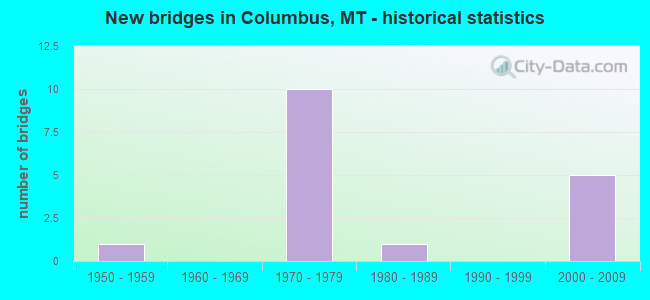
- New bridges - historical statistics
- 11950-1959
- 101970-1979
- 11980-1989
- 52000-2009

- Reconstructed bridges - Historical Statistics
- 11970-1979
- 01980-1989
- 01990-1999
- 22000-2009


- Bridge Condition - Deck
- 38.5%Good
- 53.8%Satisfactory
- 7.7%Poor

- Bridge Condition - Superstructure
- 61.5%Good
- 38.5%Satisfactory

- Bridge Condition - Substructure
- 30.8%Good
- 61.5%Satisfactory
- 7.7%Fair

- Bridge Condition - Channel
- 11.1%Very good
- 66.7%Good
- 22.2%Satisfactory
Find on map >> Show street view
Structure Number: I00090407+08621, Location: 1.2M W COLUMBUS (Lat: 45.654719, Lng: -109.265997), Route carried "on" structure: Interstate 90, Year Built: 1971, Year Reconstructed: 2014, Status: Open, Structure Length: 5.82m (19.09ft), Average Daily Traffic: 9,184 (year 2020), Truck Traffic: 20%, Average Future Daily Traffic: 9,781 (year 2040), Design Load: HS 20, Features Intersected: KEYSER CREEK
Minimum Vertical Clearance: 30+ m (98+ ft), Kilometerpoint: 652.904, Lanes on structure: 2, Base Highway Network: Yes, Owner: State Highway Agency, Approaching Roadway Width: 12.5m (41.0ft), Skew: 3 degrees, Material/Design: Prestressed concrete, Design/Construction: Stringer/Multi-beam, Number Of Spans In Main Unit: 3, Length of Maximum Span: 23.3m (76.4ft), Curb-To-Curb Width: 12.6m (41.3ft), Out-to-Out Width: 13.5m (44.3ft)
Condition: Deck: Satisfactory, Superstructure: Good, Substructure: Satisfactory, Channel: Good, Operating Rating: 47.2 metric tons, Method Used To Determine Operating Rating: Load and Resistance Factor (LRFR), Inventory Rating: 24.5 metric tons, Method Used To Determine Inventory Rating: Load and Resistance Factor (LRFR), Structural Evaluation: Equal to present minimum criteria, Deck Geometry: Better than present minimum criteria, Waterway Adequacy: Superior to present desirable criteria, Approach Roadway Alignment: Equal to present desirable criteria, Designated Inspection Frequency: Every 24 months, Inspection Date: December 2021, Deck Structure Type: Concrete Cast-file-Place, Wearing Surface/Protective System: Wearing Surface: Monolithic Concrete
Find on map >> Show street view
Structure Number: I00090407+08622, Location: 1.2M W COLUMBUS (Lat: 45.655100, Lng: -109.266056), Route carried "on" structure: Interstate 90, Year Built: 1971, Year Reconstructed: 2014, Status: Open, Structure Length: 5.82m (19.09ft), Average Daily Traffic: 9,184 (year 2020), Truck Traffic: 20%, Average Future Daily Traffic: 9,781 (year 2040), Design Load: HS 20, Features Intersected: KEYSER CREEK
Minimum Vertical Clearance: 30+ m (98+ ft), Kilometerpoint: 653.088, Lanes on structure: 2, Base Highway Network: Yes, Owner: State Highway Agency, Approaching Roadway Width: 12.5m (41.0ft), Skew: 3 degrees, Material/Design: Prestressed concrete, Design/Construction: Stringer/Multi-beam, Number Of Spans In Main Unit: 3, Length of Maximum Span: 23.3m (76.4ft), Curb-To-Curb Width: 12.6m (41.3ft), Out-to-Out Width: 13.5m (44.3ft)
Condition: Deck: Satisfactory, Superstructure: Good, Substructure: Satisfactory, Channel: Good, Operating Rating: 47.2 metric tons, Method Used To Determine Operating Rating: Load and Resistance Factor (LRFR), Inventory Rating: 24.5 metric tons, Method Used To Determine Inventory Rating: Load and Resistance Factor (LRFR), Structural Evaluation: Equal to present minimum criteria, Deck Geometry: Better than present minimum criteria, Waterway Adequacy: Superior to present desirable criteria, Approach Roadway Alignment: Equal to present desirable criteria, Designated Inspection Frequency: Every 24 months, Inspection Date: November 2021, Deck Structure Type: Concrete Cast-file-Place, Wearing Surface/Protective System: Wearing Surface: Monolithic Concrete
Find on map >> Show street view
Structure Number: I00090408+09031, Location: COLUMBUS (Lat: 45.646694, Lng: -109.247814), Route carried "on" structure: Interstate 90, Year Built: 1971, Status: Open, Structure Length: 4.30m (14.11ft), Average Daily Traffic: 11,155 (year 2020), Truck Traffic: 21%, Average Future Daily Traffic: 12,271 (year 2040), Design Load: HS 20, Features Intersected: INT COLUMBUS-9TH ST N
Minimum Vertical Clearance: 30+ m (98+ ft), Kilometerpoint: 654.581, Lanes on structure: 2, Lanes under structure: 2, Base Highway Network: Yes, Owner: State Highway Agency, Approaching Roadway Width: 11.6m (38.1ft), Skew: 1 degrees, Material/Design: Prestressed concrete, Design/Construction: Stringer/Multi-beam, Number Of Spans In Main Unit: 3, Length of Maximum Span: 23.5m (77.1ft), Curb or Sidewalk Widths: Left: 0.1m (0.3ft), Right: 0.1m (0.3ft), Curb-To-Curb Width: 11.6m (38.1ft), Out-to-Out Width: 12.4m (40.7ft)
Condition: Deck: Good, Superstructure: Good, Substructure: Satisfactory, Operating Rating: 46.3 metric tons, Method Used To Determine Operating Rating: Load and Resistance Factor (LRFR), Inventory Rating: 23.6 metric tons, Method Used To Determine Inventory Rating: Load and Resistance Factor (LRFR), Structural Evaluation: Somewhat better than minimum adequacy, Deck Geometry: Equal to present minimum criteria, Underclear: Equal to present minimum criteria, Approach Roadway Alignment: Equal to present desirable criteria, Designated Inspection Frequency: Every 24 months, Inspection Date: Febuary 2022, Deck Structure Type: Concrete Cast-file-Place, Wearing Surface/Protective System: Wearing Surface: Monolithic Concrete
Find on map >> Show street view
Structure Number: I00090408+09032, Location: COLUMBUS (Lat: 45.647008, Lng: -109.247775), Route carried "on" structure: Interstate 90, Year Built: 1971, Status: Open, Structure Length: 4.30m (14.11ft), Average Daily Traffic: 11,155 (year 2020), Truck Traffic: 21%, Average Future Daily Traffic: 12,271 (year 2040), Design Load: HS 20, Features Intersected: INT COLUMBUS-9TH ST N
Minimum Vertical Clearance: 30+ m (98+ ft), Kilometerpoint: 654.777, Lanes on structure: 2, Lanes under structure: 2, Base Highway Network: Yes, Owner: State Highway Agency, Approaching Roadway Width: 11.6m (38.1ft), Skew: 1 degrees, Material/Design: Prestressed concrete, Design/Construction: Stringer/Multi-beam, Number Of Spans In Main Unit: 3, Length of Maximum Span: 23.5m (77.1ft), Curb-To-Curb Width: 11.6m (38.1ft), Out-to-Out Width: 12.4m (40.7ft)
Condition: Deck: Good, Superstructure: Satisfactory, Substructure: Satisfactory, Operating Rating: 46.3 metric tons, Method Used To Determine Operating Rating: Load and Resistance Factor (LRFR), Inventory Rating: 23.6 metric tons, Method Used To Determine Inventory Rating: Load and Resistance Factor (LRFR), Structural Evaluation: Somewhat better than minimum adequacy, Deck Geometry: Equal to present minimum criteria, Underclear: Better than present minimum criteria, Approach Roadway Alignment: Equal to present desirable criteria, Designated Inspection Frequency: Every 24 months, Inspection Date: Febuary 2022, Deck Structure Type: Concrete Cast-file-Place, Wearing Surface/Protective System: Wearing Surface: Monolithic Concrete
Find on map >> Show street view
Structure Number: L48096000+01001, Location: 2M E COLUMBUS (Lat: 45.630556, Lng: -109.199578), Route carried "on" structure: Spur County highway 48004, Year Built: 1970, Status: Open, Structure Length: 9.51m (31.20ft), Average Daily Traffic: 100 (year 2022), Truck Traffic: 3%, Average Future Daily Traffic: 100 (year 2037), Design Load: HS 15, Features Intersected: SEP COLUMBUS-MOLT RD I 9, Facility Carried by Structure: COLUMBUS-MOLT RD
Minimum Vertical Clearance: 30+ m (98+ ft), Kilometerpoint: 0.154, Lanes on structure: 2, Lanes under structure: 4, Owner: State Highway Agency, Approaching Roadway Width: 9.1m (29.9ft), Skew: 1 degrees, Material/Design: Steel continuous, Design/Construction: Stringer/Multi-beam, Number Of Spans In Main Unit: 4, Length of Maximum Span: 29.0m (95.1ft), Curb or Sidewalk Widths: Left: 0.1m (0.3ft), Right: 0.1m (0.3ft), Curb-To-Curb Width: 9.6m (31.5ft), Out-to-Out Width: 10.4m (34.1ft)
Condition: Deck: Satisfactory, Superstructure: Satisfactory, Substructure: Good, Operating Rating: 50.8 metric tons, Method Used To Determine Operating Rating: Load Factor (LF), Inventory Rating: 29.9 metric tons, Method Used To Determine Inventory Rating: Load Factor (LF), Structural Evaluation: Equal to present minimum criteria, Deck Geometry: Better than present minimum criteria, Underclear: Equal to present minimum criteria, Approach Roadway Alignment: Meets minimum limits, Designated Inspection Frequency: Every 24 months, Inspection Date: March 2020, Deck Structure Type: Concrete Cast-file-Place, Wearing Surface/Protective System: Wearing Surface: Monolithic Concrete
Find on map >> Show street view
Structure Number: L48117000+03001, Location: 1M SW COLUMBUS (Lat: 45.623586, Lng: -109.286033), Route carried "on" structure: County highway 48205, Year Built: 2006, Status: Open, Structure Length: 2.13m (6.99ft), Average Daily Traffic: 100 (year 2022), Truck Traffic: 3%, Average Future Daily Traffic: 100 (year 2037), Features Intersected: STILLWATER R OVFLOW 002, Facility Carried by Structure: COUNTRYMAN CR RD
Minimum Vertical Clearance: 30+ m (98+ ft), Kilometerpoint: 0.561, Lanes on structure: 2, Owner: County Highway Agency, Approaching Roadway Width: 8.0m (26.2ft), Material/Design: Prestressed concrete, Design/Construction: Tee Beam, Number Of Spans In Main Unit: 1, Length of Maximum Span: 21.3m (69.9ft), Curb-To-Curb Width: 7.2m (23.6ft), Out-to-Out Width: 7.9m (25.9ft)
Condition: Deck: Satisfactory, Superstructure: Satisfactory, Substructure: Satisfactory, Channel: Good, Operating Rating: 54.4 metric tons, Method Used To Determine Operating Rating: Field evaluation and documented engineering judgment, Inventory Rating: 32.7 metric tons, Method Used To Determine Inventory Rating: Field evaluation and documented engineering judgment, Structural Evaluation: Equal to present minimum criteria, Deck Geometry: Somewhat better than minimum adequacy, Waterway Adequacy: Equal to present desirable criteria, Approach Roadway Alignment: Equal to present minimum criteria, Designated Inspection Frequency: Every 24 months, Inspection Date: September 2020, Deck Structure Type: Concrete Precast Panels
Find on map >> Show street view
Structure Number: L48117000+04001, Location: 1M SW COLUMBUS (Lat: 45.623511, Lng: -109.288608), Route carried "on" structure: County highway 48205, Year Built: 1988, Status: Open, Structure Length: 5.85m (19.19ft), Average Daily Traffic: 100 (year 2022), Truck Traffic: 3%, Average Future Daily Traffic: 100 (year 2037), Design Load: HS 20, Features Intersected: STILLWATER RIVER 003, Facility Carried by Structure: COUNTRYMAN CR RD
Minimum Vertical Clearance: 30+ m (98+ ft), Kilometerpoint: 0.781, Lanes on structure: 2, Owner: County Highway Agency, Approaching Roadway Width: 6.7m (22.0ft), Material/Design: Steel continuous, Design/Construction: Stringer/Multi-beam, Number Of Spans In Main Unit: 3, Length of Maximum Span: 21.3m (69.9ft), Curb-To-Curb Width: 7.3m (24.0ft), Out-to-Out Width: 8.0m (26.2ft)
Condition: Deck: Good, Superstructure: Good, Substructure: Satisfactory, Channel: Good, Operating Rating: 59.0 metric tons, Method Used To Determine Operating Rating: Load Factor (LF), Inventory Rating: 35.4 metric tons, Method Used To Determine Inventory Rating: Load Factor (LF), Structural Evaluation: Equal to present minimum criteria, Deck Geometry: Equal to present minimum criteria, Waterway Adequacy: Equal to present desirable criteria, Approach Roadway Alignment: Equal to present minimum criteria, Designated Inspection Frequency: Every 24 months, Inspection Date: September 2020, Deck Structure Type: Concrete Cast-file-Place, Wearing Surface/Protective System: Wearing Surface: Monolithic Concrete
Find on map >> Show street view
Structure Number: L48242000+03001, Location: NW EDGE COLUMBUS (Lat: 45.645967, Lng: -109.268614), Route carried "on" structure: County highway 48242, Year Built: 2005, Status: Open, Structure Length: 1.41m (4.63ft), Average Daily Traffic: 100 (year 2022), Truck Traffic: 3%, Average Future Daily Traffic: 100 (year 2037), Design Load: HS 20, Features Intersected: KEYSER CREEK 043, Facility Carried by Structure: CENTENNIAL RD
Minimum Vertical Clearance: 30+ m (98+ ft), Kilometerpoint: 0.771, Lanes on structure: 2, Owner: County Highway Agency, Approaching Roadway Width: 6.2m (20.3ft), Material/Design: Prestressed concrete, Design/Construction: Tee Beam, Number Of Spans In Main Unit: 1, Length of Maximum Span: 14.1m (46.3ft), Curb or Sidewalk Widths: Left: 0.0m, Right: 3.5m (11.5ft), Curb-To-Curb Width: 6.1m (20.0ft), Out-to-Out Width: 10.9m (35.8ft)
Condition: Deck: Good, Superstructure: Good, Substructure: Good, Channel: Good, Operating Rating: 50.7 metric tons, Method Used To Determine Operating Rating: Load Factor (LF), Inventory Rating: 39.7 metric tons, Method Used To Determine Inventory Rating: Load Factor (LF), Structural Evaluation: Better than present minimum criteria, Deck Geometry: Somewhat better than minimum adequacy, Waterway Adequacy: Equal to present desirable criteria, Approach Roadway Alignment: Equal to present minimum criteria, Designated Inspection Frequency: Every 24 months, Inspection Date: January 2021, Deck Structure Type: Concrete Precast Panels
Find on map >> Show street view
Structure Number: P00078042+00391, Location: 4M SW COLUMBUS (Lat: 45.593889, Lng: -109.296944), Route carried "on" structure: State highway 78, Year Built: 2007, Status: Open, Structure Length: 2.98m (9.78ft), Average Daily Traffic: 2,612 (year 2020), Truck Traffic: 3%, Average Future Daily Traffic: 2,743 (year 2040), Design Load: HL 93, Features Intersected: JOE HILL CREEK
Minimum Vertical Clearance: 30+ m (98+ ft), Kilometerpoint: 67.506, Lanes on structure: 2, Base Highway Network: Yes, Owner: State Highway Agency, Approaching Roadway Width: 12.0m (39.4ft), Skew: 2 degrees, Material/Design: Prestressed concrete, Design/Construction: Stringer/Multi-beam, Number Of Spans In Main Unit: 1, Length of Maximum Span: 29.0m (95.1ft), Curb-To-Curb Width: 12.0m (39.4ft), Out-to-Out Width: 12.7m (41.7ft)
Condition: Deck: Good, Superstructure: Good, Substructure: Good, Channel: Good, Operating Rating: 57.2 metric tons, Method Used To Determine Operating Rating: Load and Resistance Factor (LRFR), Inventory Rating: 35.4 metric tons, Method Used To Determine Inventory Rating: Load and Resistance Factor (LRFR), Structural Evaluation: Better than present minimum criteria, Deck Geometry: Somewhat better than minimum adequacy, Waterway Adequacy: Superior to present desirable criteria, Approach Roadway Alignment: Equal to present minimum criteria, Length Of Structure Improvement: 1.30m (4.27ft), Designated Inspection Frequency: Every 24 months, Inspection Date: September 2021, Bridge Improvement Cost: $33,000, Roadway Improvement Cost: $7,000, Total Project Cost: $41,000, Deck Structure Type: Concrete Cast-file-Place, Wearing Surface/Protective System: Wearing Surface: Bituminous, Membrane: Preformed Fabric
Find on map >> Show street view
Structure Number: P00078043+05911, Location: 3M S COLUMBUS (Lat: 45.612889, Lng: -109.280106), Route carried "on" structure: State highway 78, Year Built: 2007, Status: Open, Structure Length: 3.98m (13.06ft), Average Daily Traffic: 2,612 (year 2020), Truck Traffic: 3%, Average Future Daily Traffic: 2,743 (year 2040), Design Load: HS 20, Features Intersected: SHANE CREEK
Minimum Vertical Clearance: 30+ m (98+ ft), Kilometerpoint: 69.981, Lanes on structure: 2, Base Highway Network: Yes, Owner: State Highway Agency, Approaching Roadway Width: 12.0m (39.4ft), Material/Design: Prestressed concrete, Design/Construction: Stringer/Multi-beam, Number Of Spans In Main Unit: 1, Length of Maximum Span: 39.0m (128.0ft), Curb-To-Curb Width: 12.0m (39.4ft), Out-to-Out Width: 12.7m (41.7ft)
Condition: Deck: Satisfactory, Superstructure: Good, Substructure: Satisfactory, Channel: Satisfactory, Operating Rating: 51.7 metric tons, Method Used To Determine Operating Rating: Load and Resistance Factor (LRFR), Inventory Rating: 31.8 metric tons, Method Used To Determine Inventory Rating: Load and Resistance Factor (LRFR), Structural Evaluation: Equal to present minimum criteria, Deck Geometry: Somewhat better than minimum adequacy, Waterway Adequacy: Superior to present desirable criteria, Approach Roadway Alignment: Equal to present minimum criteria, Length Of Structure Improvement: 3.90m (12.80ft), Designated Inspection Frequency: Every 24 months, Inspection Date: September 2021, Bridge Improvement Cost: $100,000, Roadway Improvement Cost: $10,000, Total Project Cost: $111,000, Deck Structure Type: Concrete Cast-file-Place, Wearing Surface/Protective System: Wearing Surface: Monolithic Concrete
Find on map >> Show street view
Structure Number: P00078046+01371, Location: COLUMBUS (Lat: 45.628700, Lng: -109.254956), Route carried "on" structure: State highway 78, Year Built: 1957, Status: Open, Structure Length: 17.55m (57.58ft), Average Daily Traffic: 4,367 (year 2020), Truck Traffic: 2%, Average Future Daily Traffic: 4,585 (year 2040), Design Load: HS 20, Features Intersected: YELLOWSTONE RIVER
Minimum Vertical Clearance: 30+ m (98+ ft), Kilometerpoint: 74.180, Lanes on structure: 2, Base Highway Network: Yes, Owner: State Highway Agency, Approaching Roadway Width: 9.1m (29.9ft), Material/Design: Steel continuous, Design/Construction: Girder and Floorbeam System, Number Of Spans In Main Unit: 4, Length of Maximum Span: 48.8m (160.1ft), Curb-To-Curb Width: 8.5m (27.9ft), Out-to-Out Width: 9.4m (30.8ft)
Condition: Deck: Poor, Superstructure: Satisfactory, Substructure: Fair, Channel: Satisfactory, Operating Rating: 50.8 metric tons, Method Used To Determine Operating Rating: Load Factor (LF), Inventory Rating: 30.8 metric tons, Method Used To Determine Inventory Rating: Load Factor (LF), Structural Evaluation: Somewhat better than minimum adequacy, Deck Geometry: Meets minimum limits, Waterway Adequacy: Superior to present desirable criteria, Approach Roadway Alignment: Equal to present minimum criteria, Designated Inspection Frequency: Every 24 months, Critical Feature Inspection Frequency: Every 24 months, Underwater Inspection Frequency: Every 60 months, Inspection Date: August 2021, Critical Feature Inspection Date: August 2021, Underwater Inspection Date: August 2020, Deck Structure Type: Concrete Cast-file-Place, Wearing Surface/Protective System: Wearing Surface: Monolithic Concrete
Find on map >> Show street view
Structure Number: S00306000+09691, Location: 1M W COLUMBUS (Lat: 45.640933, Lng: -109.271392), Route carried "on" structure: State highway 306, Year Built: 2004, Status: Open, Structure Length: 3.05m (10.01ft), Average Daily Traffic: 1,079 (year 2020), Truck Traffic: 4%, Average Future Daily Traffic: 1,133 (year 2040), Design Load: HS 25 or greater, Features Intersected: KEYSER CREEK, Facility Carried by Structure: HWY 10
Minimum Vertical Clearance: 30+ m (98+ ft), Kilometerpoint: 1.555, Lanes on structure: 2, Owner: State Highway Agency, Approaching Roadway Width: 9.6m (31.5ft), Skew: 2 degrees, Material/Design: Prestressed concrete, Design/Construction: Stringer/Multi-beam, Number Of Spans In Main Unit: 1, Length of Maximum Span: 29.5m (96.8ft), Curb-To-Curb Width: 9.6m (31.5ft), Out-to-Out Width: 10.3m (33.8ft)
Condition: Deck: Satisfactory, Superstructure: Good, Substructure: Good, Channel: Very good, Operating Rating: 64.1 metric tons, Method Used To Determine Operating Rating: Load Factor (LF), Inventory Rating: 46.2 metric tons, Method Used To Determine Inventory Rating: Load Factor (LF), Structural Evaluation: Better than present minimum criteria, Deck Geometry: Somewhat better than minimum adequacy, Waterway Adequacy: Superior to present desirable criteria, Approach Roadway Alignment: Equal to present desirable criteria, Designated Inspection Frequency: Every 24 months, Inspection Date: October 2020, Deck Structure Type: Concrete Cast-file-Place, Wearing Surface/Protective System: Deck Protection: Epoxy Coated Reinforcing
Find on map >> Show street view
Structure Number: S00306002+02091, Location: 1M N COLUMBUS (Lat: 45.656294, Lng: -109.274233), Route carried "on" structure: State highway 306, Year Built: 1971, Year Reconstructed: 1983, Status: Open, Structure Length: 15.02m (49.28ft), Average Daily Traffic: 532 (year 2020), Average Future Daily Traffic: 564 (year 2040), Design Load: HS 20, Features Intersected: SEP RAPELJE-I 90, Facility Carried by Structure: RAPELJE RD
Minimum Vertical Clearance: 30+ m (98+ ft), Kilometerpoint: 3.458, Lanes on structure: 2, Lanes under structure: 4, Owner: State Highway Agency, Approaching Roadway Width: 9.8m (32.2ft), Material/Design: Prestressed concrete, Design/Construction: Stringer/Multi-beam, Number Of Spans In Main Unit: 6, Length of Maximum Span: 31.1m (102.0ft), Curb or Sidewalk Widths: Left: 0.1m (0.3ft), Right: 0.1m (0.3ft), Curb-To-Curb Width: 9.6m (31.5ft), Out-to-Out Width: 10.4m (34.1ft)
Condition: Deck: Satisfactory, Superstructure: Satisfactory, Substructure: Satisfactory, Operating Rating: 48.1 metric tons, Method Used To Determine Operating Rating: Load and Resistance Factor (LRFR), Inventory Rating: 21.8 metric tons, Method Used To Determine Inventory Rating: Load and Resistance Factor (LRFR), Structural Evaluation: Somewhat better than minimum adequacy, Deck Geometry: Equal to present minimum criteria, Underclear: Equal to present minimum criteria, Approach Roadway Alignment: Equal to present minimum criteria, Designated Inspection Frequency: Every 24 months, Inspection Date: April 2020, Deck Structure Type: Concrete Cast-file-Place, Wearing Surface/Protective System: Wearing Surface: Monolithic Concrete
Find on map >> Show street view
Structure Number: I00090408+09031, Location: COLUMBUS (Lat: 45.646694, Lng: -109.247814), Route carried "under" structure: State highway 78, Year Built: 1971, Structure Length: 0. m, Average Daily Traffic: 100 (year 2022), Truck Traffic: 3%, Features Intersected: INT COLUMBUS-9TH ST N, Facility Carried by Structure: I 90
Minimum Vertical Clearance: 4.82m (15.81ft), Kilometerpoint: 76.774, Lanes on structure: 2, Lanes under structure: 2, Material/Design: Prestressed concrete, Design/Construction: Stringer/Multi-beam, Length of Maximum Span: 23.5m (77.1ft)
Find on map >> Show street view
Structure Number: I00090408+09032, Location: COLUMBUS (Lat: 45.647008, Lng: -109.247775), Route carried "under" structure: State highway 78, Year Built: 1971, Structure Length: 0. m, Average Daily Traffic: 100 (year 2022), Truck Traffic: 3%, Features Intersected: INT COLUMBUS-9TH ST N, Facility Carried by Structure: I 90
Minimum Vertical Clearance: 4.75m (15.58ft), Kilometerpoint: 76.774, Lanes on structure: 2, Lanes under structure: 2, Material/Design: Prestressed concrete, Design/Construction: Stringer/Multi-beam, Length of Maximum Span: 23.5m (77.1ft)
Find on map >> Show street view
Structure Number: L48096000+01001, Location: 2M E COLUMBUS (Lat: 45.630556, Lng: -109.199578), Route carried "under" structure: Interstate 90, Year Built: 1970, Structure Length: 0. m, Average Daily Traffic: 11,155 (year 2020), Truck Traffic: 21%, Features Intersected: SEP COLUMBUS-MOLT RD I 9, Facility Carried by Structure: COLUMBUS-MOLT RD
Minimum Vertical Clearance: 5.23m (17.16ft), Kilometerpoint: 658.767, Lanes on structure: 2, Lanes under structure: 4, Material/Design: Steel continuous, Design/Construction: Stringer/Multi-beam, Length of Maximum Span: 29.0m (95.1ft)
Find on map >> Show street view
Structure Number: S00306002+02091, Location: 1M N COLUMBUS (Lat: 45.656294, Lng: -109.274233), Route carried "under" structure: Interstate 90, Year Built: 1971, Structure Length: 0. m, Average Daily Traffic: 9,184 (year 2020), Truck Traffic: 20%, Features Intersected: SEP RAPELJE-I 90, Facility Carried by Structure: RAPELJE RD
Minimum Vertical Clearance: 5.05m (16.57ft), Kilometerpoint: 652.243, Lanes on structure: 2, Lanes under structure: 4, Material/Design: Prestressed concrete, Design/Construction: Stringer/Multi-beam, Length of Maximum Span: 31.1m (102.0ft)