Bridge Statistics for Commack, New York (NY)
Condition, Traffic, Stress, Structural Evaluation, Project Costs
- National Bridge Inventory (NBI) Statistics
- 40Number of bridges
- 236ft / 71.6mTotal length
- $118,398,000Total costs
- 1,652,752Total average daily traffic
- 42,934Total average daily truck traffic
- National Bridge Inventory (NBI) Registered Bridges for Commack
- No street view available for this location
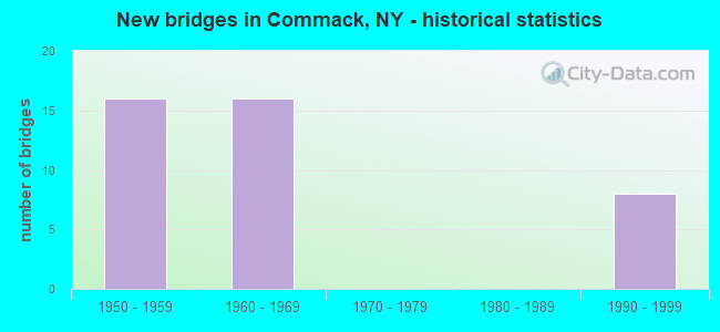
- New bridges - historical statistics
- 161950-1959
- 161960-1969
- 81990-1999
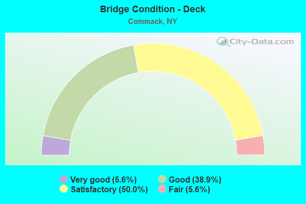
- Bridge Condition - Deck
- 5.6%Very good
- 38.9%Good
- 50.0%Satisfactory
- 5.6%Fair
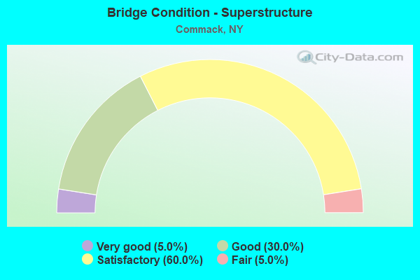
- Bridge Condition - Superstructure
- 5.0%Very good
- 30.0%Good
- 60.0%Satisfactory
- 5.0%Fair
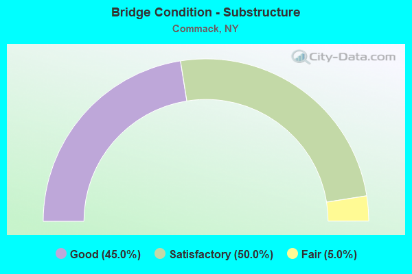
- Bridge Condition - Substructure
- 45.0%Good
- 50.0%Satisfactory
- 5.0%Fair
Find on map >> Show street view
Structure Number: 1049361, Location: 2.5 MI E JCT RTS 231+495 (Lat: 40.804758, Lng: -73.294633), Route carried "on" structure: Interstate 495, Year Built: 1963, Year Reconstructed: 1994, Status: Open, Structure Length: 4.11m (13.48ft), Average Daily Traffic: 78,935 (year 2002), Truck Traffic: 13%, Design Load: HS 20+Mod, Features Intersected: CR4-COMMACK ROAD
Minimum Vertical Clearance: 30+ m (98+ ft), Kilometerpoint: 13.162, Lanes on structure: 5, Lanes under structure: 5, Base Highway Network: Yes, Owner: State Highway Agency, Approaching Roadway Width: 29.0m (95.1ft), Material/Design: Steel, Design/Construction: Stringer/Multi-beam, Number Of Spans In Main Unit: 3, Length of Maximum Span: 21.6m (70.9ft), Curb-To-Curb Width: 28.8m (94.5ft), Out-to-Out Width: 29.8m (97.8ft)
Condition: Deck: Satisfactory, Superstructure: Satisfactory, Substructure: Satisfactory, Operating Rating: 61.7 metric tons, Method Used To Determine Operating Rating: Load Factor (LF), Inventory Rating: 34.5 metric tons, Method Used To Determine Inventory Rating: Load Factor (LF), Structural Evaluation: Equal to present minimum criteria, Deck Geometry: Superior to present desirable criteria, Underclear: High priority of corrective action, Approach Roadway Alignment: Better than present minimum criteria, Length Of Structure Improvement: 4.11m (13.48ft), Designated Inspection Frequency: Every 24 months, Inspection Date: October 2020, Bridge Improvement Cost: $4,902,000, Roadway Improvement Cost: $2,870,000, Total Project Cost: $7,772,000 ( Estimate for 2021), Deck Structure Type: Concrete Cast-file-Place, Wearing Surface/Protective System: Wearing Surface: Integral Concrete
Find on map >> Show street view
Structure Number: 1049362, Location: 2.5 MI E JCT RTS 231+495 (Lat: 40.804483, Lng: -73.294644), Route carried "on" structure: Interstate 495, Year Built: 1963, Year Reconstructed: 1992, Status: Open, Structure Length: 4.11m (13.48ft), Average Daily Traffic: 73,249 (year 2018), Truck Traffic: 10%, Average Future Daily Traffic: 76,911 (year 2040), Design Load: HS 20+Mod, Features Intersected: CR4-COMMACK ROAD
Minimum Vertical Clearance: 30+ m (98+ ft), Kilometerpoint: 13.162, Lanes on structure: 5, Lanes under structure: 5, Base Highway Network: Yes, Owner: State Highway Agency, Approaching Roadway Width: 29.0m (95.1ft), Material/Design: Steel, Design/Construction: Stringer/Multi-beam, Number Of Spans In Main Unit: 3, Length of Maximum Span: 21.6m (70.9ft), Curb-To-Curb Width: 29.1m (95.5ft), Out-to-Out Width: 30.1m (98.8ft)
Condition: Deck: Satisfactory, Superstructure: Satisfactory, Substructure: Satisfactory, Operating Rating: 61.7 metric tons, Method Used To Determine Operating Rating: Load Factor (LF), Inventory Rating: 34.5 metric tons, Method Used To Determine Inventory Rating: Load Factor (LF), Structural Evaluation: Equal to present minimum criteria, Deck Geometry: Superior to present desirable criteria, Underclear: High priority of corrective action, Approach Roadway Alignment: Equal to present desirable criteria, Length Of Structure Improvement: 4.11m (13.48ft), Designated Inspection Frequency: Every 24 months, Inspection Date: October 2020, Bridge Improvement Cost: $4,942,000, Roadway Improvement Cost: $2,894,000, Total Project Cost: $7,835,000 ( Estimate for 2021), Deck Structure Type: Concrete Cast-file-Place, Wearing Surface/Protective System: Wearing Surface: Integral Concrete
Find on map >> Show street view
Structure Number: 1049371, Location: .4 MI W JCT SAGTIKOS &LIE (Lat: 40.805214, Lng: -73.287869), Route carried "on" structure: ServiceState highway 906B, Year Built: 1993, Status: Open, Structure Length: 2.50m (8.20ft), Average Daily Traffic: 10,479 (year 2020), Truck Traffic: 11%, Average Future Daily Traffic: 12,090 (year 2040), Design Load: HS 20, Features Intersected: CR13- CROOK HL RD
Minimum Vertical Clearance: 30+ m (98+ ft), Kilometerpoint: 29.847, Lanes on structure: 3, Lanes under structure: 3, Base Highway Network: Yes, Owner: State Highway Agency, Approaching Roadway Width: 15.8m (51.8ft), Skew: 3 degrees, Material/Design: Steel, Design/Construction: Stringer/Multi-beam, Number Of Spans In Main Unit: 1, Length of Maximum Span: 23.7m (77.8ft), Curb-To-Curb Width: 15.8m (51.8ft), Out-to-Out Width: 16.6m (54.5ft)
Condition: Deck: Good, Superstructure: Good, Substructure: Good, Operating Rating: 59.0 metric tons, Method Used To Determine Operating Rating: Load Factor (LF), Inventory Rating: 32.7 metric tons, Method Used To Determine Inventory Rating: Load Factor (LF), Structural Evaluation: Better than present minimum criteria, Deck Geometry: Better than present minimum criteria, Underclear: Meets minimum limits, Approach Roadway Alignment: Equal to present desirable criteria, Length Of Structure Improvement: 2.49m (8.17ft), Designated Inspection Frequency: Every 24 months, Inspection Date: May 2021, Bridge Improvement Cost: $3,215,000, Roadway Improvement Cost: $1,883,000, Total Project Cost: $5,098,000 ( Estimate for 2021), Deck Structure Type: Concrete Cast-file-Place, Wearing Surface/Protective System: Wearing Surface: Integral Concrete, Deck Protection: Epoxy Coated Reinforcing
Find on map >> Show street view
Structure Number: 1049372, Location: 2.9 MI E JCT SH231 & I495 (Lat: 40.805019, Lng: -73.287711), Route carried "on" structure: Interstate 495, Year Built: 1964, Year Reconstructed: 1994, Status: Open, Structure Length: 2.56m (8.40ft), Average Daily Traffic: 61,586 (year 2002), Truck Traffic: 13%, Design Load: HS 20+Mod, Features Intersected: CR13- CROOK HL RD
Minimum Vertical Clearance: 30+ m (98+ ft), Kilometerpoint: 13.773, Lanes on structure: 4, Lanes under structure: 3, Base Highway Network: Yes, Owner: State Highway Agency, Approaching Roadway Width: 24.1m (79.1ft), Skew: 3 degrees, Material/Design: Steel, Design/Construction: Stringer/Multi-beam, Number Of Spans In Main Unit: 1, Length of Maximum Span: 24.0m (78.7ft), Curb-To-Curb Width: 24.2m (79.4ft), Out-to-Out Width: 25.2m (82.7ft)
Condition: Deck: Satisfactory, Superstructure: Satisfactory, Substructure: Satisfactory, Operating Rating: 63.5 metric tons, Method Used To Determine Operating Rating: Load Factor (LF), Inventory Rating: 32.7 metric tons, Method Used To Determine Inventory Rating: Load Factor (LF), Structural Evaluation: Equal to present minimum criteria, Deck Geometry: Superior to present desirable criteria, Underclear: Meets minimum limits, Approach Roadway Alignment: Better than present minimum criteria, Length Of Structure Improvement: 2.56m (8.40ft), Designated Inspection Frequency: Every 24 months, Inspection Date: May 2021, Bridge Improvement Cost: $4,760,000, Roadway Improvement Cost: $2,787,000, Total Project Cost: $7,547,000 ( Estimate for 2021), Deck Structure Type: Concrete Cast-file-Place, Wearing Surface/Protective System: Wearing Surface: Integral Concrete
Find on map >> Show street view
Structure Number: 1049373, Location: 2.9 MI E JCT SH231 & I495 (Lat: 40.804756, Lng: -73.287500), Route carried "on" structure: Interstate 495, Year Built: 1964, Year Reconstructed: 1994, Status: Open, Structure Length: 2.56m (8.40ft), Average Daily Traffic: 97,642 (year 2018), Truck Traffic: 10%, Average Future Daily Traffic: 102,524 (year 2040), Design Load: HS 20+Mod, Features Intersected: CR13- CROOK HL RD
Minimum Vertical Clearance: 30+ m (98+ ft), Kilometerpoint: 13.773, Lanes on structure: 4, Lanes under structure: 3, Base Highway Network: Yes, Owner: State Highway Agency, Approaching Roadway Width: 24.1m (79.1ft), Skew: 3 degrees, Material/Design: Steel, Design/Construction: Stringer/Multi-beam, Number Of Spans In Main Unit: 1, Length of Maximum Span: 24.0m (78.7ft), Curb-To-Curb Width: 24.1m (79.1ft), Out-to-Out Width: 25.2m (82.7ft)
Condition: Deck: Satisfactory, Superstructure: Satisfactory, Substructure: Satisfactory, Operating Rating: 63.5 metric tons, Method Used To Determine Operating Rating: Load Factor (LF), Inventory Rating: 32.7 metric tons, Method Used To Determine Inventory Rating: Load Factor (LF), Structural Evaluation: Equal to present minimum criteria, Deck Geometry: Superior to present desirable criteria, Underclear: Meets minimum limits, Approach Roadway Alignment: Better than present minimum criteria, Length Of Structure Improvement: 2.56m (8.40ft), Designated Inspection Frequency: Every 24 months, Inspection Date: May 2021, Bridge Improvement Cost: $4,573,000, Roadway Improvement Cost: $2,678,000, Total Project Cost: $7,251,000 ( Estimate for 2021), Deck Structure Type: Concrete Cast-file-Place, Wearing Surface/Protective System: Wearing Surface: Integral Concrete
Find on map >> Show street view
Structure Number: 1049374, Location: 2.9 MI E JCT SH231 & I495 (Lat: 40.804597, Lng: -73.287369), Route carried "on" structure: ServiceState highway 906A, Year Built: 1991, Status: Open, Structure Length: 2.56m (8.40ft), Average Daily Traffic: 12,011 (year 2020), Truck Traffic: 9%, Average Future Daily Traffic: 13,858 (year 2040), Design Load: HS 20, Features Intersected: CR13- CROOK HL RD
Minimum Vertical Clearance: 30+ m (98+ ft), Kilometerpoint: 13.918, Lanes on structure: 3, Lanes under structure: 3, Base Highway Network: Yes, Owner: State Highway Agency, Approaching Roadway Width: 15.8m (51.8ft), Skew: 3 degrees, Material/Design: Steel, Design/Construction: Stringer/Multi-beam, Number Of Spans In Main Unit: 1, Length of Maximum Span: 24.0m (78.7ft), Curb-To-Curb Width: 15.7m (51.5ft), Out-to-Out Width: 16.6m (54.5ft)
Condition: Deck: Good, Superstructure: Good, Substructure: Satisfactory, Operating Rating: 80.7 metric tons, Method Used To Determine Operating Rating: Load Factor (LF), Inventory Rating: 48.1 metric tons, Method Used To Determine Inventory Rating: Load Factor (LF), Structural Evaluation: Equal to present minimum criteria, Deck Geometry: Better than present minimum criteria, Underclear: Meets minimum limits, Approach Roadway Alignment: Equal to present desirable criteria, Length Of Structure Improvement: 2.56m (8.40ft), Designated Inspection Frequency: Every 24 months, Inspection Date: May 2021, Bridge Improvement Cost: $3,023,000, Roadway Improvement Cost: $1,770,000, Total Project Cost: $4,793,000 ( Estimate for 2021), Deck Structure Type: Concrete Cast-file-Place, Wearing Surface/Protective System: Wearing Surface: Integral Concrete, Deck Protection: Epoxy Coated Reinforcing
Find on map >> Show street view
Structure Number: 1056171, Location: .5 MI SE JCT SH454 & SH25 (Lat: 40.839733, Lng: -73.281439), Route carried "on" structure: Bypass State highway 454, Year Built: 1953, Status: Open, Structure Length: 2.56m (8.40ft), Average Daily Traffic: 6,406 (year 2020), Truck Traffic: 11%, Average Future Daily Traffic: 7,391 (year 2040), Design Load: H 20, Features Intersected: 908K 908K 0701 1066, N/B
Minimum Vertical Clearance: 30+ m (98+ ft), Kilometerpoint: 0.837, Lanes on structure: 2, Lanes under structure: 4, Base Highway Network: Yes, Owner: State Highway Agency, Approaching Roadway Width: 11.3m (37.1ft), Skew: 2 degrees, Material/Design: Concrete, Design/Construction: Frame, Number Of Spans In Main Unit: 1, Length of Maximum Span: 22.5m (73.8ft), Curb or Sidewalk Widths: Left: 2.4m (7.9ft), Right: 1.3m (4.3ft), Curb-To-Curb Width: 11.3m (37.1ft), Out-to-Out Width: 16.0m (52.5ft)
Condition: Deck: Good, Superstructure: Good, Substructure: Good, Operating Rating: 88.0 metric tons, Method Used To Determine Operating Rating: Load Factor (LF), Inventory Rating: 38.1 metric tons, Method Used To Determine Inventory Rating: Load Factor (LF), Structural Evaluation: Better than present minimum criteria, Deck Geometry: Equal to present minimum criteria, Underclear: High priority of corrective action, Approach Roadway Alignment: Better than present minimum criteria, Length Of Structure Improvement: 2.56m (8.40ft), Designated Inspection Frequency: Every 24 months, Inspection Date: Febuary 2020, Bridge Improvement Cost: $2,383,000, Roadway Improvement Cost: $1,396,000, Total Project Cost: $3,779,000 ( Estimate for 2021), Wearing Surface/Protective System: Wearing Surface: Bituminous, Membrane: Preformed Fabric
Find on map >> Show street view
Structure Number: 1056172, Location: .5 MI SE JCT SH454 & SH25 (Lat: 40.839525, Lng: -73.281306), Route carried "on" structure: Bypass State highway 454, Year Built: 1953, Status: Open, Structure Length: 2.56m (8.40ft), Average Daily Traffic: 6,406 (year 2020), Truck Traffic: 11%, Average Future Daily Traffic: 7,391 (year 2040), Design Load: H 20, Features Intersected: 908K 908K 0701 1066, N/B
Minimum Vertical Clearance: 30+ m (98+ ft), Kilometerpoint: 0.837, Lanes on structure: 2, Lanes under structure: 4, Base Highway Network: Yes, Owner: State Highway Agency, Approaching Roadway Width: 11.3m (37.1ft), Skew: 2 degrees, Material/Design: Concrete, Design/Construction: Frame, Number Of Spans In Main Unit: 1, Length of Maximum Span: 22.6m (74.1ft), Curb or Sidewalk Widths: Left: 1.4m (4.6ft), Right: 2.4m (7.9ft), Curb-To-Curb Width: 11.3m (37.1ft), Out-to-Out Width: 16.0m (52.5ft)
Condition: Deck: Good, Superstructure: Satisfactory, Substructure: Satisfactory, Operating Rating: 88.0 metric tons, Method Used To Determine Operating Rating: Load Factor (LF), Inventory Rating: 38.1 metric tons, Method Used To Determine Inventory Rating: Load Factor (LF), Structural Evaluation: Equal to present minimum criteria, Deck Geometry: Equal to present minimum criteria, Underclear: High priority of corrective action, Approach Roadway Alignment: Better than present minimum criteria, Length Of Structure Improvement: 2.56m (8.40ft), Designated Inspection Frequency: Every 24 months, Inspection Date: Febuary 2020, Bridge Improvement Cost: $2,383,000, Roadway Improvement Cost: $1,396,000, Total Project Cost: $3,779,000 ( Estimate for 2021), Wearing Surface/Protective System: Wearing Surface: Bituminous, Membrane: Preformed Fabric
Find on map >> Show street view
Structure Number: 1056739, Location: 2.9 MI E JCT SH 231 & NSP (Lat: 40.815858, Lng: -73.288853), Route carried "on" structure: Other road , Year Built: 1951, Status: Open, Structure Length: 7.10m (23.29ft), Average Daily Traffic: 13,969 (year 2020), Truck Traffic: 4%, Average Future Daily Traffic: 16,969 (year 2040), Features Intersected: 908K908K07011048, RTE 90, Facility Carried by Structure: L.I. MOTOR PKWY
Minimum Vertical Clearance: 30+ m (98+ ft), Kilometerpoint: 7.755, Lanes on structure: 4, Lanes under structure: 6, Owner: State Highway Agency, Approaching Roadway Width: 14.6m (47.9ft), Skew: 4 degrees, Material/Design: Steel, Design/Construction: Stringer/Multi-beam, Number Of Spans In Main Unit: 4, Length of Maximum Span: 24.3m (79.7ft), Curb or Sidewalk Widths: Left: 1.8m (5.9ft), Right: 1.8m (5.9ft), Curb-To-Curb Width: 14.6m (47.9ft), Out-to-Out Width: 19.3m (63.3ft)
Condition: Deck: Satisfactory, Superstructure: Satisfactory, Substructure: Satisfactory, Operating Rating: 43.4 metric tons, Method Used To Determine Operating Rating: Load and Resistance Factor Rating (LRFR) rating reported by rating factor(RF) method using HL-93 loadings, Inventory Rating: 33.4 metric tons, Method Used To Determine Inventory Rating: Load and Resistance Factor Rating (LRFR) rating reported by rating factor(RF) method using HL-93 loadings, Structural Evaluation: Equal to present minimum criteria, Deck Geometry: High priority of replacement, Underclear: High priority of corrective action, Approach Roadway Alignment: Equal to present desirable criteria, Length Of Structure Improvement: 7.10m (23.29ft), Designated Inspection Frequency: Every 24 months, Inspection Date: March 2020, Bridge Improvement Cost: $6,259,000, Roadway Improvement Cost: $3,665,000, Total Project Cost: $9,924,000 ( Estimate for 2021), Deck Structure Type: Concrete Cast-file-Place, Wearing Surface/Protective System: Wearing Surface: Integral Concrete
Find on map >> Show street view
Structure Number: 105743, Location: 4.4 MI E JCT SH 231 & NSP (Lat: 40.824317, Lng: -73.262628), Route carried "on" structure: City street , Year Built: 1964, Status: Open, Structure Length: 2.26m (7.41ft), Average Daily Traffic: 3,334 (year 2020), Truck Traffic: 4%, Average Future Daily Traffic: 4,125 (year 2040), Design Load: H 20, Features Intersected: RTE 908G, Facility Carried by Structure: NEW HIGHWAY
Minimum Vertical Clearance: 30+ m (98+ ft), Kilometerpoint: 2.607, Lanes on structure: 4, Lanes under structure: 2, Owner: State Highway Agency, Approaching Roadway Width: 14.6m (47.9ft), Skew: 2 degrees, Material/Design: Concrete, Design/Construction: Arch - Deck, Number Of Spans In Main Unit: 1, Length of Maximum Span: 20.1m (65.9ft), Curb or Sidewalk Widths: Left: 1.5m (4.9ft), Right: 1.5m (4.9ft), Curb-To-Curb Width: 14.6m (47.9ft), Out-to-Out Width: 18.6m (61.0ft)
Condition: Superstructure: Good, Substructure: Good, Operating Rating: 58.7 metric tons, Method Used To Determine Operating Rating: Field evaluation and documented engineering judgment, Inventory Rating: 23.0 metric tons, Method Used To Determine Inventory Rating: Field evaluation and documented engineering judgment, Structural Evaluation: Equal to present minimum criteria, Deck Geometry: High priority of replacement, Underclear: High priority of corrective action, Approach Roadway Alignment: Equal to present desirable criteria, Length Of Structure Improvement: 2.25m (7.38ft), Designated Inspection Frequency: Every 24 months, Inspection Date: Febuary 2020, Bridge Improvement Cost: $3,498,000, Roadway Improvement Cost: $2,048,000, Total Project Cost: $5,546,000 ( Estimate for 2021), Wearing Surface/Protective System: Wearing Surface: Bituminous, Membrane: Preformed Fabric
Find on map >> Show street view
Structure Number: 105841, Location: 2.9 MI E JCT RTS 231+NSP (Lat: 40.817556, Lng: -73.287300), Route carried "on" structure: Other road , Year Built: 1964, Status: Open, Structure Length: 1.40m (4.59ft), Average Daily Traffic: 8,060 (year 2019), Truck Traffic: 6%, Average Future Daily Traffic: 11,284 (year 2039), Design Load: HS 20, Features Intersected: SGSP NB TO NSP EB, Facility Carried by Structure: HARNED RD
Minimum Vertical Clearance: 30+ m (98+ ft), Kilometerpoint: 0.225, Lanes on structure: 2, Lanes under structure: 1, Owner: State Highway Agency, Approaching Roadway Width: 14.6m (47.9ft), Skew: 22 degrees, Material/Design: Concrete, Design/Construction: Frame, Number Of Spans In Main Unit: 1, Length of Maximum Span: 12.8m (42.0ft), Curb or Sidewalk Widths: Left: 1.5m (4.9ft), Right: 1.5m (4.9ft), Curb-To-Curb Width: 14.6m (47.9ft), Out-to-Out Width: 18.6m (61.0ft)
Condition: Deck: Good, Superstructure: Satisfactory, Substructure: Satisfactory, Operating Rating: 81.6 metric tons, Method Used To Determine Operating Rating: Field evaluation and documented engineering judgment, Inventory Rating: 32.7 metric tons, Method Used To Determine Inventory Rating: Field evaluation and documented engineering judgment, Structural Evaluation: Equal to present minimum criteria, Deck Geometry: Superior to present desirable criteria, Underclear: High priority of corrective action, Approach Roadway Alignment: Equal to present desirable criteria, Length Of Structure Improvement: 1.40m (4.59ft), Designated Inspection Frequency: Every 24 months, Inspection Date: March 2021, Bridge Improvement Cost: $1,978,000, Roadway Improvement Cost: $1,158,000, Total Project Cost: $3,137,000 ( Estimate for 2021), Wearing Surface/Protective System: Wearing Surface: Bituminous, Membrane: Preformed Fabric
Find on map >> Show street view
Structure Number: 105842, Location: 2.9 MI E JCT RTS 231+NSP (Lat: 40.818192, Lng: -73.287253), Route carried "on" structure: County highway , Year Built: 1964, Status: Open, Structure Length: 3.78m (12.40ft), Average Daily Traffic: 8,060 (year 2019), Truck Traffic: 6%, Average Future Daily Traffic: 11,284 (year 2039), Design Load: H 20, Features Intersected: 908G908G07021097 WB, RTE, Facility Carried by Structure: HARNED ROAD
Minimum Vertical Clearance: 30+ m (98+ ft), Kilometerpoint: 0.290, Lanes on structure: 2, Lanes under structure: 5, Owner: State Highway Agency, Approaching Roadway Width: 14.6m (47.9ft), Skew: 20 degrees, Material/Design: Concrete continuous, Design/Construction: Frame, Number Of Spans In Main Unit: 2, Length of Maximum Span: 17.3m (56.8ft), Curb or Sidewalk Widths: Left: 1.4m (4.6ft), Right: 1.4m (4.6ft), Curb-To-Curb Width: 14.6m (47.9ft), Out-to-Out Width: 18.6m (61.0ft)
Condition: Deck: Satisfactory, Superstructure: Satisfactory, Substructure: Satisfactory, Operating Rating: 54.9 metric tons, Method Used To Determine Operating Rating: Field evaluation and documented engineering judgment, Inventory Rating: 20.0 metric tons, Method Used To Determine Inventory Rating: Field evaluation and documented engineering judgment, Structural Evaluation: Somewhat better than minimum adequacy, Deck Geometry: Superior to present desirable criteria, Underclear: High priority of corrective action, Approach Roadway Alignment: Equal to present desirable criteria, Length Of Structure Improvement: 3.77m (12.37ft), Designated Inspection Frequency: Every 24 months, Inspection Date: Febuary 2020, Bridge Improvement Cost: $3,501,000, Roadway Improvement Cost: $2,050,000, Total Project Cost: $5,552,000 ( Estimate for 2021), Wearing Surface/Protective System: Wearing Surface: Bituminous, Membrane: Preformed Fabric
Find on map >> Show street view
Structure Number: 105843, Location: 4.4 MI E JCT SH 231 & NSP (Lat: 40.824233, Lng: -73.262172), Route carried "on" structure: County highway , Year Built: 1964, Status: Open, Structure Length: 2.44m (8.01ft), Average Daily Traffic: 3,334 (year 2020), Truck Traffic: 4%, Average Future Daily Traffic: 4,125 (year 2040), Design Load: H 20, Features Intersected: RTE 908G, Facility Carried by Structure: NEW HIGHWAY
Minimum Vertical Clearance: 30+ m (98+ ft), Kilometerpoint: 2.671, Lanes on structure: 2, Lanes under structure: 2, Owner: State Highway Agency, Approaching Roadway Width: 14.6m (47.9ft), Skew: 22 degrees, Material/Design: Concrete, Design/Construction: Arch - Deck, Number Of Spans In Main Unit: 1, Length of Maximum Span: 21.9m (71.9ft), Curb or Sidewalk Widths: Left: 1.5m (4.9ft), Right: 1.5m (4.9ft), Curb-To-Curb Width: 14.6m (47.9ft), Out-to-Out Width: 18.6m (61.0ft)
Condition: Superstructure: Good, Substructure: Good, Operating Rating: 61.0 metric tons, Method Used To Determine Operating Rating: Field evaluation and documented engineering judgment, Inventory Rating: 23.6 metric tons, Method Used To Determine Inventory Rating: Field evaluation and documented engineering judgment, Structural Evaluation: Equal to present minimum criteria, Deck Geometry: Superior to present desirable criteria, Underclear: High priority of corrective action, Approach Roadway Alignment: Equal to present desirable criteria, Length Of Structure Improvement: 2.43m (7.97ft), Designated Inspection Frequency: Every 24 months, Inspection Date: Febuary 2020, Bridge Improvement Cost: $3,727,000, Roadway Improvement Cost: $2,182,000, Total Project Cost: $5,909,000 ( Estimate for 2021), Wearing Surface/Protective System: Wearing Surface: Bituminous, Membrane: Preformed Fabric
Find on map >> Show street view
Structure Number: 1058989, Location: 2.8 MI E JCT RTS 231+NSP (Lat: 40.818325, Lng: -73.289697), Route carried "on" structure: State highway 908G, Year Built: 1953, Status: Open, Structure Length: 3.35m (10.99ft), Average Daily Traffic: 45,273 (year 2019), Average Future Daily Traffic: 53,852 (year 2040), Design Load: HS 20, Features Intersected: 908K 908K07011050, S/B,
Minimum Vertical Clearance: 30+ m (98+ ft), Kilometerpoint: 15.720, Lanes on structure: 6, Lanes under structure: 6, Base Highway Network: Yes, Owner: State Highway Agency, Approaching Roadway Width: 26.6m (87.3ft), Skew: 20 degrees, Material/Design: Concrete continuous, Design/Construction: Frame, Number Of Spans In Main Unit: 2, Length of Maximum Span: 14.6m (47.9ft), Curb-To-Curb Width: 26.6m (87.3ft), Out-to-Out Width: 31.1m (102.0ft)
Condition: Deck: Satisfactory, Superstructure: Satisfactory, Substructure: Good, Operating Rating: 83.0 metric tons, Method Used To Determine Operating Rating: Field evaluation and documented engineering judgment, Inventory Rating: 32.7 metric tons, Method Used To Determine Inventory Rating: Field evaluation and documented engineering judgment, Structural Evaluation: Equal to present minimum criteria, Deck Geometry: Somewhat better than minimum adequacy, Underclear: High priority of corrective action, Approach Roadway Alignment: Equal to present desirable criteria, Length Of Structure Improvement: 3.35m (10.99ft), Designated Inspection Frequency: Every 24 months, Inspection Date: June 2021, Bridge Improvement Cost: $5,279,000, Roadway Improvement Cost: $3,091,000, Total Project Cost: $8,370,000 ( Estimate for 2021), Wearing Surface/Protective System: Wearing Surface: Monolithic Concrete
Find on map >> Show street view
Structure Number: 105899, Location: 1 MI S JCT RTS 454+25 (Lat: 40.827492, Lng: -73.285569), Route carried "on" structure: Other road , Year Built: 1953, Status: Open, Structure Length: 2.59m (8.50ft), Average Daily Traffic: 2,884 (year 2020), Truck Traffic: 3%, Average Future Daily Traffic: 3,568 (year 2040), Design Load: H 20, Features Intersected: 908K 908K 0701 1056, N/B, Facility Carried by Structure: NEW HIGHWAY
Minimum Vertical Clearance: 30+ m (98+ ft), Kilometerpoint: 0.579, Lanes on structure: 2, Lanes under structure: 4, Owner: State Highway Agency, Approaching Roadway Width: 9.1m (29.9ft), Skew: 2 degrees, Material/Design: Concrete, Design/Construction: Frame, Number Of Spans In Main Unit: 1, Length of Maximum Span: 22.2m (72.8ft), Curb or Sidewalk Widths: Left: 2.3m (7.5ft), Right: 2.3m (7.5ft), Curb-To-Curb Width: 9.1m (29.9ft), Out-to-Out Width: 14.9m (48.9ft)
Condition: Deck: Satisfactory, Superstructure: Satisfactory, Substructure: Good, Operating Rating: 61.3 metric tons, Method Used To Determine Operating Rating: Field evaluation and documented engineering judgment, Inventory Rating: 23.7 metric tons, Method Used To Determine Inventory Rating: Field evaluation and documented engineering judgment, Structural Evaluation: Equal to present minimum criteria, Deck Geometry: Meets minimum limits, Underclear: High priority of corrective action, Approach Roadway Alignment: Equal to present desirable criteria, Length Of Structure Improvement: 2.59m (8.50ft), Designated Inspection Frequency: Every 24 months, Inspection Date: Febuary 2020, Bridge Improvement Cost: $2,190,000, Roadway Improvement Cost: $1,283,000, Total Project Cost: $3,473,000 ( Estimate for 2021), Wearing Surface/Protective System: Wearing Surface: Bituminous, Membrane: Preformed Fabric
Find on map >> Show street view
Structure Number: 1059009, Location: .4 MI NE JCT RTS 454+25 (Lat: 40.843706, Lng: -73.281558), Route carried "on" structure: State highway 908K, Year Built: 1954, Status: Open, Structure Length: 4.27m (14.01ft), Average Daily Traffic: 45,612 (year 2018), Truck Traffic: 1%, Average Future Daily Traffic: 54,255 (year 2040), Design Load: H 20, Features Intersected: 25 25 07041095 E/B, RTE
Minimum Vertical Clearance: 30+ m (98+ ft), Kilometerpoint: 11.601, Lanes on structure: 6, Lanes under structure: 6, Base Highway Network: Yes, Owner: State Highway Agency, Approaching Roadway Width: 25.6m (84.0ft), Skew: 21 degrees, Material/Design: Concrete continuous, Design/Construction: Frame, Number Of Spans In Main Unit: 2, Length of Maximum Span: 19.2m (63.0ft), Curb-To-Curb Width: 25.5m (83.7ft), Out-to-Out Width: 27.8m (91.2ft)
Condition: Deck: Fair, Superstructure: Fair, Substructure: Satisfactory, Operating Rating: 57.6 metric tons, Method Used To Determine Operating Rating: Field evaluation and documented engineering judgment, Inventory Rating: 22.8 metric tons, Method Used To Determine Inventory Rating: Field evaluation and documented engineering judgment, Structural Evaluation: Somewhat better than minimum adequacy, Deck Geometry: Meets minimum limits, Underclear: Equal to present minimum criteria, Approach Roadway Alignment: Equal to present desirable criteria, Length Of Structure Improvement: 4.26m (13.98ft), Designated Inspection Frequency: Every 24 months, Inspection Date: May 2020, Bridge Improvement Cost: $6,467,000, Roadway Improvement Cost: $3,787,000, Total Project Cost: $10,253,000 ( Estimate for 2021), Wearing Surface/Protective System: Wearing Surface: Bituminous, Membrane: Preformed Fabric
Find on map >> Show street view
Structure Number: 105901, Location: 1.4 MI NE JCT RTS 454+25 (Lat: 40.860014, Lng: -73.276306), Route carried "on" structure: City street , Year Built: 1955, Status: Open, Structure Length: 2.38m (7.81ft), Average Daily Traffic: 5,421 (year 2017), Truck Traffic: 3%, Average Future Daily Traffic: 6,707 (year 2040), Design Load: H 20, Features Intersected: 908K 908K 0701 1081, N/B, Facility Carried by Structure: SCHOLAR LANE
Minimum Vertical Clearance: 30+ m (98+ ft), Kilometerpoint: 1.207, Lanes on structure: 2, Lanes under structure: 4, Owner: State Highway Agency, Approaching Roadway Width: 9.1m (29.9ft), Material/Design: Concrete, Design/Construction: Frame, Number Of Spans In Main Unit: 1, Length of Maximum Span: 20.4m (66.9ft), Curb or Sidewalk Widths: Left: 3.0m (9.8ft), Right: 3.0m (9.8ft), Curb-To-Curb Width: 9.1m (29.9ft), Out-to-Out Width: 16.2m (53.1ft)
Condition: Deck: Satisfactory, Superstructure: Satisfactory, Substructure: Good, Operating Rating: 59.1 metric tons, Method Used To Determine Operating Rating: Field evaluation and documented engineering judgment, Inventory Rating: 23.1 metric tons, Method Used To Determine Inventory Rating: Field evaluation and documented engineering judgment, Structural Evaluation: Somewhat better than minimum adequacy, Deck Geometry: High priority of corrective action, Underclear: High priority of corrective action, Approach Roadway Alignment: Meets minimum limits, Length Of Structure Improvement: 2.37m (7.78ft), Designated Inspection Frequency: Every 24 months, Inspection Date: Febuary 2020, Bridge Improvement Cost: $2,136,000, Roadway Improvement Cost: $1,251,000, Total Project Cost: $3,386,000 ( Estimate for 2021), Wearing Surface/Protective System: Wearing Surface: Bituminous, Membrane: Preformed Fabric
Find on map >> Show street view
Structure Number: 105902, Location: 1.7 MI S SMSP+RTE 25A (Lat: 40.875431, Lng: -73.279469), Route carried "on" structure: Other road , Year Built: 1955, Status: Open, Structure Length: 2.32m (7.61ft), Average Daily Traffic: 4,651 (year 2020), Truck Traffic: 18%, Average Future Daily Traffic: 5,754 (year 2040), Design Load: H 20, Features Intersected: 908K908K07011091, N/B, R, Facility Carried by Structure: OLD NORTHPORT RD
Minimum Vertical Clearance: 30+ m (98+ ft), Kilometerpoint: 0.805, Lanes on structure: 2, Lanes under structure: 4, Owner: State Highway Agency, Approaching Roadway Width: 9.1m (29.9ft), Material/Design: Concrete, Design/Construction: Frame, Number Of Spans In Main Unit: 1, Length of Maximum Span: 20.1m (65.9ft), Curb or Sidewalk Widths: Left: 2.3m (7.5ft), Right: 2.3m (7.5ft), Curb-To-Curb Width: 9.1m (29.9ft), Out-to-Out Width: 14.9m (48.9ft)
Condition: Deck: Good, Superstructure: Satisfactory, Substructure: Fair, Operating Rating: 58.7 metric tons, Method Used To Determine Operating Rating: Field evaluation and documented engineering judgment, Inventory Rating: 23.0 metric tons, Method Used To Determine Inventory Rating: Field evaluation and documented engineering judgment, Structural Evaluation: Somewhat better than minimum adequacy, Deck Geometry: Meets minimum limits, Underclear: High priority of corrective action, Approach Roadway Alignment: Equal to present desirable criteria, Length Of Structure Improvement: 2.31m (7.58ft), Designated Inspection Frequency: Every 24 months, Inspection Date: Febuary 2020, Bridge Improvement Cost: $1,970,000, Roadway Improvement Cost: $1,154,000, Total Project Cost: $3,123,000 ( Estimate for 2021), Wearing Surface/Protective System: Wearing Surface: Bituminous, Membrane: Preformed Fabric
Find on map >> Show street view
Structure Number: 107461, Location: JCT SAGTIKOS PKWY & I-495 (Lat: 40.807081, Lng: -73.281911), Route carried "on" structure: Ramp State highway , Year Built: 1993, Status: Open, Structure Length: 5.73m (18.80ft), Average Daily Traffic: 15,229 (year 2018), Truck Traffic: 2%, Average Future Daily Traffic: 18,114 (year 2040), Design Load: HS 20, Features Intersected: 908K908K07011042 N/B, RT, Facility Carried by Structure: 906B WB TO SGSP SB
Minimum Vertical Clearance: 30+ m (98+ ft), Kilometerpoint: 0.274, Lanes on structure: 2, Lanes under structure: 4, Owner: State Highway Agency, Approaching Roadway Width: 10.4m (34.1ft), Material/Design: Steel, Design/Construction: Stringer/Multi-beam, Number Of Spans In Main Unit: 2, Length of Maximum Span: 28.0m (91.9ft), Curb-To-Curb Width: 10.2m (33.5ft), Out-to-Out Width: 11.2m (36.7ft)
Condition: Deck: Very good, Superstructure: Very good, Substructure: Good, Operating Rating: 71.7 metric tons, Method Used To Determine Operating Rating: Load Factor (LF), Inventory Rating: 40.8 metric tons, Method Used To Determine Inventory Rating: Load Factor (LF), Structural Evaluation: Better than present minimum criteria, Deck Geometry: Equal to present minimum criteria, Underclear: High priority of corrective action, Approach Roadway Alignment: Equal to present desirable criteria, Length Of Structure Improvement: 5.73m (18.80ft), Designated Inspection Frequency: Every 24 months, Inspection Date: March 2020, Bridge Improvement Cost: $2,778,000, Roadway Improvement Cost: $1,627,000, Total Project Cost: $4,404,000 ( Estimate for 2021), Deck Structure Type: Concrete Cast-file-Place, Wearing Surface/Protective System: Wearing Surface: Integral Concrete, Deck Protection: Epoxy Coated Reinforcing
Find on map >> Show street view
Structure Number: 107462, Location: JCTS SAGTIKOS ST PKWY&LIE (Lat: 40.805019, Lng: -73.283925), Route carried "on" structure: Ramp State highway , Year Built: 1993, Status: Open, Structure Length: 10.49m (34.42ft), Average Daily Traffic: 15,229 (year 2018), Truck Traffic: 2%, Average Future Daily Traffic: 18,114 (year 2040), Design Load: HS 20, Features Intersected: 495I 495I 0703 1088 East, Facility Carried by Structure: RAMP495WB-SGSPSB
Minimum Vertical Clearance: 30+ m (98+ ft), Kilometerpoint: 0.563, Lanes on structure: 2, Lanes under structure: 10, Owner: State Highway Agency, Approaching Roadway Width: 10.4m (34.1ft), Skew: 1 degrees, Material/Design: Steel continuous, Design/Construction: Stringer/Multi-beam, Number Of Spans In Main Unit: 4, Length of Maximum Span: 25.9m (85.0ft), Curb-To-Curb Width: 10.4m (34.1ft), Out-to-Out Width: 11.2m (36.7ft)
Condition: Deck: Good, Superstructure: Good, Substructure: Good, Operating Rating: 89.8 metric tons, Method Used To Determine Operating Rating: Load Factor (LF), Inventory Rating: 32.7 metric tons, Method Used To Determine Inventory Rating: Load Factor (LF), Structural Evaluation: Better than present minimum criteria, Deck Geometry: Better than present minimum criteria, Underclear: Meets minimum limits, Approach Roadway Alignment: Equal to present desirable criteria, Length Of Structure Improvement: 10.48m (34.38ft), Designated Inspection Frequency: Every 24 months, Inspection Date: December 2021, Bridge Improvement Cost: $4,709,000, Roadway Improvement Cost: $2,758,000, Total Project Cost: $7,467,000 ( Estimate for 2021), Deck Structure Type: Concrete Cast-file-Place, Wearing Surface/Protective System: Wearing Surface: Integral Concrete, Deck Protection: Epoxy Coated Reinforcing
Find on map >> Show street view
Structure Number: 1049361, Location: 2.5 MI E JCT RTS 231+495 (Lat: 40.804758, Lng: -73.294633), Route carried "under" structure: County highway , Year Built: 1963, Structure Length: 0. m, Average Daily Traffic: 43,052 (year 2005), Features Intersected: CR4-COMMACK ROAD, Facility Carried by Structure: RTE I495
Minimum Vertical Clearance: 4.42m (14.50ft), Kilometerpoint: 0.000, Lanes on structure: 5, Lanes under structure: 5, Material/Design: Steel, Design/Construction: Stringer/Multi-beam, Length of Maximum Span: 21.6m (70.9ft)
Find on map >> Show street view
Structure Number: 1049362, Location: 2.5 MI E JCT RTS 231+495 (Lat: 40.804483, Lng: -73.294644), Route carried "under" structure: County highway , Year Built: 1963, Structure Length: 0. m, Average Daily Traffic: 43,052 (year 2005), Features Intersected: CR4-COMMACK ROAD, Facility Carried by Structure: RTE I495
Minimum Vertical Clearance: 4.45m (14.60ft), Kilometerpoint: 0.000, Lanes on structure: 5, Lanes under structure: 5, Material/Design: Steel, Design/Construction: Stringer/Multi-beam, Length of Maximum Span: 21.6m (70.9ft)
Find on map >> Show street view
Structure Number: 1049371, Location: .4 MI W JCT SAGTIKOS &LIE (Lat: 40.805214, Lng: -73.287869), Route carried "under" structure: County highway , Year Built: 1993, Structure Length: 0. m, Average Daily Traffic: 33,996 (year 2005), Features Intersected: CR13- CROOK HL RD, Facility Carried by Structure: RTE 906B
Minimum Vertical Clearance: 5.36m (17.59ft), Kilometerpoint: 0.000, Lanes on structure: 3, Lanes under structure: 3, Material/Design: Steel, Design/Construction: Stringer/Multi-beam, Length of Maximum Span: 23.7m (77.8ft)
Find on map >> Show street view
Structure Number: 1049372, Location: 2.9 MI E JCT SH231 & I495 (Lat: 40.805019, Lng: -73.287711), Route carried "under" structure: County highway , Year Built: 1964, Structure Length: 0. m, Average Daily Traffic: 33,996 (year 2005), Features Intersected: CR13- CROOK HL RD, Facility Carried by Structure: RTE I495
Minimum Vertical Clearance: 5.74m (18.83ft), Kilometerpoint: 0.000, Lanes on structure: 4, Lanes under structure: 3, Material/Design: Steel, Design/Construction: Stringer/Multi-beam, Length of Maximum Span: 24.0m (78.7ft)
Find on map >> Show street view
Structure Number: 1049373, Location: 2.9 MI E JCT SH231 & I495 (Lat: 40.804756, Lng: -73.287500), Route carried "under" structure: County highway , Year Built: 1964, Structure Length: 0. m, Average Daily Traffic: 33,996 (year 2005), Features Intersected: CR13- CROOK HL RD, Facility Carried by Structure: RTE I495
Minimum Vertical Clearance: 5.18m (16.99ft), Kilometerpoint: 0.000, Lanes on structure: 4, Lanes under structure: 3, Material/Design: Steel, Design/Construction: Stringer/Multi-beam, Length of Maximum Span: 24.0m (78.7ft)
Find on map >> Show street view
Structure Number: 1049374, Location: 2.9 MI E JCT SH231 & I495 (Lat: 40.804597, Lng: -73.287369), Route carried "under" structure: County highway , Year Built: 1991, Structure Length: 0. m, Average Daily Traffic: 33,996 (year 2005), Features Intersected: CR13- CROOK HL RD, Facility Carried by Structure: RTE 906A
Minimum Vertical Clearance: 5.16m (16.93ft), Kilometerpoint: 0.000, Lanes on structure: 3, Lanes under structure: 3, Material/Design: Steel, Design/Construction: Stringer/Multi-beam, Length of Maximum Span: 24.0m (78.7ft)
Find on map >> Show street view
Structure Number: 1056171, Location: .5 MI SE JCT SH454 & SH25 (Lat: 40.839733, Lng: -73.281439), Route carried "under" structure: State highway 908K, Year Built: 1953, Structure Length: 0. m, Average Daily Traffic: 87,882 (year 2002), Features Intersected: 908K 908K 0701 1066, N/B, Facility Carried by Structure: RTE 454
Minimum Vertical Clearance: 4.75m (15.58ft), Kilometerpoint: 2.558, Lanes on structure: 2, Lanes under structure: 2, Material/Design: Concrete, Design/Construction: Frame, Length of Maximum Span: 22.5m (73.8ft)
Find on map >> Show street view
Structure Number: 1056172, Location: .5 MI SE JCT SH454 & SH25 (Lat: 40.839525, Lng: -73.281306), Route carried "under" structure: State highway 908K, Year Built: 1953, Structure Length: 0. m, Average Daily Traffic: 87,882 (year 2002), Features Intersected: 908K 908K 0701 1066, N/B, Facility Carried by Structure: RTE 454
Minimum Vertical Clearance: 4.32m (14.17ft), Kilometerpoint: 2.558, Lanes on structure: 2, Lanes under structure: 2, Material/Design: Concrete, Design/Construction: Frame, Length of Maximum Span: 22.6m (74.1ft)
Find on map >> Show street view
Structure Number: 1056739, Location: 2.9 MI E JCT SH 231 & NSP (Lat: 40.815858, Lng: -73.288853), Route carried "under" structure: State highway 908K, Year Built: 1951, Structure Length: 0. m, Average Daily Traffic: 64,875 (year 2002), Features Intersected: 908K908K07011048, RTE 90, Facility Carried by Structure: L.I. MOTOR PKWY
Minimum Vertical Clearance: 4.88m (16.01ft), Kilometerpoint: 8.125, Lanes on structure: 4, Lanes under structure: 3, Material/Design: Steel, Design/Construction: Stringer/Multi-beam, Length of Maximum Span: 24.3m (79.7ft)
Find on map >> Show street view
Structure Number: 105743, Location: 4.4 MI E JCT SH 231 & NSP (Lat: 40.824317, Lng: -73.262628), Route carried "under" structure: State highway 908G, Year Built: 1964, Structure Length: 0. m, Average Daily Traffic: 40,572 (year 2002), Features Intersected: RTE 908G, Facility Carried by Structure: NEW HIGHWAY
Minimum Vertical Clearance: 4.32m (14.17ft), Kilometerpoint: 18.294, Lanes on structure: 4, Lanes under structure: 2, Material/Design: Concrete, Design/Construction: Arch - Deck, Length of Maximum Span: 20.1m (65.9ft)
Find on map >> Show street view
Structure Number: 105841, Location: 2.9 MI E JCT RTS 231+NSP (Lat: 40.817556, Lng: -73.287300), Route carried "under" structure: Ramp State highway , Year Built: 1964, Structure Length: 0. m, Average Daily Traffic: 3,000 (year 2021), Features Intersected: SGSP NB TO NSP EB, Facility Carried by Structure: HARNED RD
Minimum Vertical Clearance: 4.32m (14.17ft), Kilometerpoint: 0.000, Lanes on structure: 2, Lanes under structure: 1, Material/Design: Concrete, Design/Construction: Frame, Length of Maximum Span: 12.8m (42.0ft)
Find on map >> Show street view
Structure Number: 105842, Location: 2.9 MI E JCT RTS 231+NSP (Lat: 40.818192, Lng: -73.287253), Route carried "under" structure: Other road 908G, Year Built: 1964, Structure Length: 0. m, Average Daily Traffic: 46,552 (year 2002), Features Intersected: 908G908G07021097 WB, RTE, Facility Carried by Structure: HARNED ROAD
Minimum Vertical Clearance: 4.32m (14.17ft), Kilometerpoint: 15.816, Lanes on structure: 2, Lanes under structure: 2, Material/Design: Concrete continuous, Design/Construction: Frame, Length of Maximum Span: 17.3m (56.8ft)
Find on map >> Show street view
Structure Number: 105843, Location: 4.4 MI E JCT SH 231 & NSP (Lat: 40.824233, Lng: -73.262172), Route carried "under" structure: State highway 908G, Year Built: 1964, Structure Length: 0. m, Average Daily Traffic: 40,572 (year 2002), Features Intersected: RTE 908G, Facility Carried by Structure: NEW HIGHWAY
Minimum Vertical Clearance: 4.39m (14.40ft), Kilometerpoint: 18.294, Lanes on structure: 2, Lanes under structure: 2, Material/Design: Concrete, Design/Construction: Arch - Deck, Length of Maximum Span: 21.9m (71.9ft)
Find on map >> Show street view
Structure Number: 1058989, Location: 2.8 MI E JCT RTS 231+NSP (Lat: 40.818325, Lng: -73.289697), Route carried "under" structure: State highway 908K, Year Built: 1953, Structure Length: 0. m, Average Daily Traffic: 48,518 (year 2002), Features Intersected: 908K 908K07011050, S/B,, Facility Carried by Structure: RTE 908G
Minimum Vertical Clearance: 4.70m (15.42ft), Kilometerpoint: 8.399, Lanes on structure: 6, Lanes under structure: 3, Material/Design: Concrete continuous, Design/Construction: Frame, Length of Maximum Span: 14.6m (47.9ft)
Find on map >> Show street view
Structure Number: 105899, Location: 1 MI S JCT RTS 454+25 (Lat: 40.827492, Lng: -73.285569), Route carried "under" structure: State highway 908K, Year Built: 1953, Structure Length: 0. m, Average Daily Traffic: 87,882 (year 2002), Features Intersected: 908K 908K 0701 1056, N/B, Facility Carried by Structure: NEW HIGHWAY
Minimum Vertical Clearance: 4.27m (14.01ft), Kilometerpoint: 1.094, Lanes on structure: 2, Lanes under structure: 2, Material/Design: Concrete, Design/Construction: Frame, Length of Maximum Span: 22.2m (72.8ft)
Find on map >> Show street view
Structure Number: 1059009, Location: .4 MI NE JCT RTS 454+25 (Lat: 40.843706, Lng: -73.281558), Route carried "under" structure: State highway 25, Year Built: 1954, Structure Length: 0. m, Average Daily Traffic: 28,546 (year 2000), Features Intersected: 25 25 07041095 E/B, RTE, Facility Carried by Structure: RTE 908K
Minimum Vertical Clearance: 5.13m (16.83ft), Kilometerpoint: 15.366, Lanes on structure: 6, Lanes under structure: 3, Material/Design: Concrete continuous, Design/Construction: Frame, Length of Maximum Span: 19.2m (63.0ft)
Find on map >> Show street view
Structure Number: 105901, Location: 1.4 MI NE JCT RTS 454+25 (Lat: 40.860014, Lng: -73.276306), Route carried "under" structure: State highway 908K, Year Built: 1955, Structure Length: 0. m, Average Daily Traffic: 73,088 (year 2002), Features Intersected: 908K 908K 0701 1081, N/B, Facility Carried by Structure: SCHOLAR LANE
Minimum Vertical Clearance: 4.44m (14.57ft), Kilometerpoint: 4.924, Lanes on structure: 2, Lanes under structure: 2, Material/Design: Concrete, Design/Construction: Frame, Length of Maximum Span: 20.4m (66.9ft)
Find on map >> Show street view
Structure Number: 105902, Location: 1.7 MI S SMSP+RTE 25A (Lat: 40.875431, Lng: -73.279469), Route carried "under" structure: State highway 908K, Year Built: 1955, Structure Length: 0. m, Average Daily Traffic: 64,875 (year 2002), Features Intersected: 908K908K07011091, N/B, R, Facility Carried by Structure: OLD NORTHPORT RD
Minimum Vertical Clearance: 4.32m (14.17ft), Kilometerpoint: 6.838, Lanes on structure: 2, Lanes under structure: 2, Material/Design: Concrete, Design/Construction: Frame, Length of Maximum Span: 20.1m (65.9ft)
Find on map >> Show street view
Structure Number: 107461, Location: JCT SAGTIKOS PKWY & I-495 (Lat: 40.807081, Lng: -73.281911), Route carried "under" structure: State highway 908K, Year Built: 1993, Structure Length: 0. m, Average Daily Traffic: 110,416 (year 1992), Features Intersected: 908K908K07011042 N/B, RT, Facility Carried by Structure: 906B WB TO SGSP SB
Minimum Vertical Clearance: 4.11m (13.48ft), Kilometerpoint: 7.096, Lanes on structure: 2, Lanes under structure: 2, Material/Design: Steel, Design/Construction: Stringer/Multi-beam, Length of Maximum Span: 28.0m (91.9ft)
Find on map >> Show street view
Structure Number: 107462, Location: JCTS SAGTIKOS ST PKWY&LIE (Lat: 40.805019, Lng: -73.283925), Route carried "under" structure: Interstate 495, Year Built: 1993, Structure Length: 0. m, Average Daily Traffic: 128,234 (year 1990), Features Intersected: 495I 495I 0703 1088 East
Minimum Vertical Clearance: 5.64m (18.50ft), Kilometerpoint: 14.159, Lanes on structure: 2, Lanes under structure: 3, Material/Design: Steel continuous, Design/Construction: Stringer/Multi-beam, Length of Maximum Span: 25.9m (85.0ft)