Bridge Statistics for Como, Illinois (IL)
Condition, Traffic, Stress, Structural Evaluation, Project Costs
- National Bridge Inventory (NBI) Statistics
- 29Number of bridges
- 735ft / 224mTotal length
- $5,160,000Total costs
- 169,800Total average daily traffic
- 55,971Total average daily truck traffic
- National Bridge Inventory (NBI) Registered Bridges for Como
- No street view available for this location
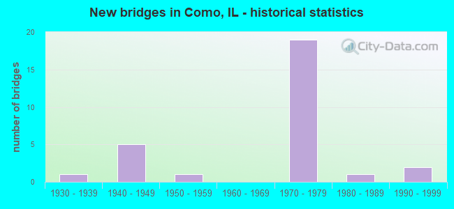
- New bridges - historical statistics
- 11930-1939
- 51940-1949
- 11950-1959
- 191970-1979
- 11980-1989
- 21990-1999

- Reconstructed bridges - Historical Statistics
- 21970-1979
- 01980-1989
- 31990-1999


- Bridge Condition - Deck
- 11.1%Good
- 27.8%Satisfactory
- 61.1%Fair

- Bridge Condition - Superstructure
- 5.6%Good
- 66.7%Satisfactory
- 27.8%Fair

- Bridge Condition - Substructure
- 22.2%Good
- 66.7%Satisfactory
- 5.6%Fair
- 5.6%Poor

- Bridge Condition - Channel
- 21.4%Very good
- 21.4%Good
- 42.9%Satisfactory
- 7.1%Fair
- 7.1%Poor

- Bridge Condition - Culverts
- 33.3%Good
- 66.7%Satisfactory
Find on map >> Show street view
Structure Number: 980032, Location: 3.5 MI W ROCK FALLS (Lat: 41.772239, Lng: -89.774139), Route carried "on" structure: US 30, Year Built: 1940, Year Reconstructed: 1984, Status: Open, Structure Length: 3.66m (12.01ft), Average Daily Traffic: 4,750 (year 2021), Truck Traffic: 12%, Average Future Daily Traffic: 6,300 (year 2040), Design Load: HS 20, Features Intersected: ELKHORN CREEK
Minimum Vertical Clearance: 30+ m (98+ ft), Kilometerpoint: 37.658, Lanes on structure: 2, Base Highway Network: Yes, Owner: State Highway Agency, Approaching Roadway Width: 12.6m (41.3ft), Material/Design: Steel continuous, Design/Construction: Stringer/Multi-beam, Number Of Spans In Main Unit: 3, Length of Maximum Span: 13.9m (45.6ft), Curb-To-Curb Width: 12.2m (40.0ft), Out-to-Out Width: 13.2m (43.3ft)
Condition: Deck: Fair, Superstructure: Good, Substructure: Good, Channel: Very good, Operating Rating: 63.8 metric tons, Method Used To Determine Operating Rating: Load Factor (LF) rating reported by rating factor (RF) method using MS18 loading, Inventory Rating: 38.2 metric tons, Method Used To Determine Inventory Rating: Load Factor (LF) rating reported by rating factor (RF) method using MS18 loading, Structural Evaluation: Better than present minimum criteria, Deck Geometry: Equal to present minimum criteria, Waterway Adequacy: Equal to present desirable criteria, Approach Roadway Alignment: Equal to present desirable criteria, Designated Inspection Frequency: Every 24 months, Inspection Date: December 2021, Deck Structure Type: Concrete Cast-file-Place, Wearing Surface/Protective System: Deck Protection: Epoxy Coated Reinforcing
Find on map >> Show street view
Structure Number: 980033, Location: .58 MI W OF COMO RD (Lat: 41.772253, Lng: -89.771617), Route carried "on" structure: US 30, Year Built: 1940, Year Reconstructed: 1984, Status: Open, Structure Length: 13.63m (44.72ft), Average Daily Traffic: 4,750 (year 2021), Truck Traffic: 12%, Average Future Daily Traffic: 6,300 (year 2040), Design Load: HS 20+Mod, Features Intersected: ELKHORN CREEK
Minimum Vertical Clearance: 30+ m (98+ ft), Kilometerpoint: 37.867, Lanes on structure: 2, Base Highway Network: Yes, Owner: State Highway Agency, Approaching Roadway Width: 12.2m (40.0ft), Material/Design: Steel, Design/Construction: Stringer/Multi-beam, Number Of Spans In Main Unit: 6, Length of Maximum Span: 27.4m (89.9ft), Curb-To-Curb Width: 12.2m (40.0ft), Out-to-Out Width: 13.2m (43.3ft)
Condition: Deck: Fair, Superstructure: Satisfactory, Substructure: Satisfactory, Channel: Satisfactory, Operating Rating: 71.6 metric tons, Method Used To Determine Operating Rating: Load Factor (LF) rating reported by rating factor (RF) method using MS18 loading, Inventory Rating: 43.1 metric tons, Method Used To Determine Inventory Rating: Load Factor (LF) rating reported by rating factor (RF) method using MS18 loading, Structural Evaluation: Equal to present minimum criteria, Deck Geometry: Equal to present minimum criteria, Waterway Adequacy: Equal to present desirable criteria, Approach Roadway Alignment: Equal to present desirable criteria, Designated Inspection Frequency: Every 24 months, Other Special Inspection Frequency: Every 12 months, Inspection Date: August 2020, Other Special Inspection Date: August 2021, Deck Structure Type: Concrete Cast-file-Place, Wearing Surface/Protective System: Deck Protection: Epoxy Coated Reinforcing
Find on map >> Show street view
Structure Number: 980034, Location: 1.5 MI W ROCK FALLS (Lat: 41.772342, Lng: -89.746336), Route carried "on" structure: US 30, Year Built: 1940, Year Reconstructed: 1990, Status: Open, Structure Length: 33.45m (109.74ft), Average Daily Traffic: 4,600 (year 2021), Truck Traffic: 14%, Average Future Daily Traffic: 5,900 (year 2040), Design Load: HS 20, Features Intersected: ROCK RIVER
Minimum Vertical Clearance: 30+ m (98+ ft), Kilometerpoint: 39.927, Lanes on structure: 2, Base Highway Network: Yes, Owner: State Highway Agency, Approaching Roadway Width: 9.1m (29.9ft), Navigation Control: Yes ( Vertical Clearance: 9.1m (29.9ft), Horizontal Clearance: 40.8m (133.9ft)), Material/Design: Steel continuous, Design/Construction: Stringer/Multi-beam, Number Of Spans In Main Unit: 8, Length of Maximum Span: 43.5m (142.7ft), Curb-To-Curb Width: 12.2m (40.0ft), Out-to-Out Width: 13.2m (43.3ft)
Condition: Deck: Satisfactory, Superstructure: Satisfactory, Substructure: Satisfactory, Channel: Satisfactory, Operating Rating: 68.7 metric tons, Method Used To Determine Operating Rating: Load Factor (LF) rating reported by rating factor (RF) method using MS18 loading, Inventory Rating: 41.1 metric tons, Method Used To Determine Inventory Rating: Load Factor (LF) rating reported by rating factor (RF) method using MS18 loading, Structural Evaluation: Equal to present minimum criteria, Deck Geometry: Equal to present minimum criteria, Waterway Adequacy: Equal to present desirable criteria, Approach Roadway Alignment: Equal to present desirable criteria, Designated Inspection Frequency: Every 24 months, Underwater Inspection Frequency: Every 24 months, Inspection Date: September 2021, Underwater Inspection Date: September 2021, Deck Structure Type: Concrete Cast-file-Place, Wearing Surface/Protective System: Wearing Surface: Latex Concrete
Find on map >> Show street view
Structure Number: 980072, Location: 5 MI NE LYNDON (Lat: 41.765339, Lng: -89.824111), Route carried "on" structure: County highway , Year Built: 1974, Status: Open, Structure Length: 7.65m (25.10ft), Average Daily Traffic: 75 (year 2022), Truck Traffic: 27%, Average Future Daily Traffic: 75 (year 2040), Design Load: HS 15, Features Intersected: I-88, Facility Carried by Structure: MATZNIK RD
Minimum Vertical Clearance: 30+ m (98+ ft), Kilometerpoint: 2.848, Lanes on structure: 2, Lanes under structure: 4, Owner: State Highway Agency, Approaching Roadway Width: 7.3m (24.0ft), Material/Design: Steel continuous, Design/Construction: Stringer/Multi-beam, Number Of Spans In Main Unit: 2, Number Of Approach Spans: 2, Length of Maximum Span: 32.9m (107.9ft), Curb-To-Curb Width: 8.7m (28.5ft), Out-to-Out Width: 9.8m (32.2ft)
Condition: Deck: Good, Superstructure: Satisfactory, Substructure: Good, Operating Rating: 39.5 metric tons, Method Used To Determine Operating Rating: Load Factor (LF) rating reported by rating factor (RF) method using MS18 loading, Inventory Rating: 24.3 metric tons, Method Used To Determine Inventory Rating: Load Factor (LF) rating reported by rating factor (RF) method using MS18 loading, Structural Evaluation: Equal to present minimum criteria, Deck Geometry: Better than present minimum criteria, Underclear: Somewhat better than minimum adequacy, Approach Roadway Alignment: Equal to present desirable criteria, Designated Inspection Frequency: Every 24 months, Inspection Date: Febuary 2020, Deck Structure Type: Concrete Cast-file-Place, Wearing Surface/Protective System: Wearing Surface: Bituminous, Membrane: Built-up
Find on map >> Show street view
Structure Number: 980073, Location: 4 MI W ROCK FALLS (Lat: 41.761331, Lng: -89.789400), Route carried "on" structure: Interstate 88, Year Built: 1974, Status: Open, Structure Length: 4.94m (16.21ft), Average Daily Traffic: 5,800 (year 2021), Truck Traffic: 34%, Average Future Daily Traffic: 7,700 (year 2040), Design Load: HS 20+Mod, Features Intersected: MOLINE RD
Minimum Vertical Clearance: 30+ m (98+ ft), Kilometerpoint: 57.661, Lanes on structure: 2, Lanes under structure: 2, Base Highway Network: Yes, Owner: State Highway Agency, Approaching Roadway Width: 12.2m (40.0ft), Skew: 2 degrees, Material/Design: Steel, Design/Construction: Stringer/Multi-beam, Number Of Spans In Main Unit: 1, Number Of Approach Spans: 2, Length of Maximum Span: 29.6m (97.1ft), Curb-To-Curb Width: 11.7m (38.4ft), Out-to-Out Width: 12.8m (42.0ft)
Condition: Deck: Satisfactory, Superstructure: Satisfactory, Substructure: Satisfactory, Operating Rating: 84.2 metric tons, Method Used To Determine Operating Rating: Load Factor (LF) rating reported by rating factor (RF) method using MS18 loading, Inventory Rating: 50.5 metric tons, Method Used To Determine Inventory Rating: Load Factor (LF) rating reported by rating factor (RF) method using MS18 loading, Structural Evaluation: Equal to present minimum criteria, Deck Geometry: Equal to present minimum criteria, Underclear: Superior to present desirable criteria, Approach Roadway Alignment: Equal to present desirable criteria, Designated Inspection Frequency: Every 24 months, Inspection Date: January 2021, Deck Structure Type: Concrete Cast-file-Place, Wearing Surface/Protective System: Wearing Surface: Other
Find on map >> Show street view
Structure Number: 980074, Location: 4 MI W ROCK FALLS (Lat: 41.761144, Lng: -89.788881), Route carried "on" structure: Interstate 88, Year Built: 1974, Status: Open, Structure Length: 4.94m (16.21ft), Average Daily Traffic: 5,800 (year 2021), Truck Traffic: 34%, Average Future Daily Traffic: 8,100 (year 2040), Design Load: HS 20+Mod, Features Intersected: MOLINE RD
Minimum Vertical Clearance: 30+ m (98+ ft), Kilometerpoint: 57.709, Lanes on structure: 2, Lanes under structure: 2, Base Highway Network: Yes, Owner: State Highway Agency, Approaching Roadway Width: 14.0m (45.9ft), Skew: 2 degrees, Material/Design: Steel, Design/Construction: Stringer/Multi-beam, Number Of Spans In Main Unit: 1, Number Of Approach Spans: 2, Length of Maximum Span: 29.6m (97.1ft), Curb-To-Curb Width: 13.8m (45.3ft), Out-to-Out Width: 15.2m (49.9ft)
Condition: Deck: Good, Superstructure: Satisfactory, Substructure: Satisfactory, Operating Rating: 97.2 metric tons, Method Used To Determine Operating Rating: Load Factor (LF) rating reported by rating factor (RF) method using MS18 loading, Inventory Rating: 60.9 metric tons, Method Used To Determine Inventory Rating: Load Factor (LF) rating reported by rating factor (RF) method using MS18 loading, Structural Evaluation: Equal to present minimum criteria, Deck Geometry: Superior to present desirable criteria, Underclear: Better than present minimum criteria, Approach Roadway Alignment: Equal to present desirable criteria, Designated Inspection Frequency: Every 24 months, Inspection Date: January 2021, Deck Structure Type: Concrete Cast-file-Place, Wearing Surface/Protective System: Wearing Surface: Other
Find on map >> Show street view
Structure Number: 980075, Location: 5.10 MI W IL 40 (Lat: 41.759772, Lng: -89.784453), Route carried "on" structure: Interstate 88, Year Built: 1972, Status: Open, Structure Length: 8.26m (27.10ft), Average Daily Traffic: 5,800 (year 2021), Truck Traffic: 34%, Average Future Daily Traffic: 7,900 (year 2040), Design Load: HS 20, Features Intersected: ELKHORN CREEK
Minimum Vertical Clearance: 30+ m (98+ ft), Kilometerpoint: 58.112, Lanes on structure: 2, Base Highway Network: Yes, Owner: State Highway Agency, Approaching Roadway Width: 12.2m (40.0ft), Material/Design: Steel continuous, Design/Construction: Stringer/Multi-beam, Number Of Spans In Main Unit: 3, Length of Maximum Span: 31.1m (102.0ft), Curb-To-Curb Width: 11.7m (38.4ft), Out-to-Out Width: 12.8m (42.0ft)
Condition: Deck: Satisfactory, Superstructure: Satisfactory, Substructure: Satisfactory, Channel: Good, Operating Rating: 93.6 metric tons, Method Used To Determine Operating Rating: Load Factor (LF) rating reported by rating factor (RF) method using MS18 loading, Inventory Rating: 50.2 metric tons, Method Used To Determine Inventory Rating: Load Factor (LF) rating reported by rating factor (RF) method using MS18 loading, Structural Evaluation: Equal to present minimum criteria, Deck Geometry: Equal to present minimum criteria, Waterway Adequacy: Equal to present desirable criteria, Approach Roadway Alignment: Equal to present desirable criteria, Length Of Structure Improvement: 8.26m (27.10ft), Designated Inspection Frequency: Every 24 months, Underwater Inspection Frequency: Every 24 months, Inspection Date: March 2021, Underwater Inspection Date: March 2021, Bridge Improvement Cost: $683,000, Roadway Improvement Cost: $68,000, Total Project Cost: $1,025,000, Deck Structure Type: Concrete Cast-file-Place, Wearing Surface/Protective System: Wearing Surface: Other
Find on map >> Show street view
Structure Number: 980076, Location: 5.10 MI W IL 40 (Lat: 41.759719, Lng: -89.784275), Route carried "on" structure: Interstate 88, Year Built: 1972, Status: Open, Structure Length: 8.26m (27.10ft), Average Daily Traffic: 5,800 (year 2021), Truck Traffic: 34%, Average Future Daily Traffic: 7,900 (year 2040), Design Load: HS 20, Features Intersected: ELKHORN CREEK
Minimum Vertical Clearance: 30+ m (98+ ft), Kilometerpoint: 58.128, Lanes on structure: 2, Base Highway Network: Yes, Owner: State Highway Agency, Approaching Roadway Width: 12.2m (40.0ft), Material/Design: Steel continuous, Design/Construction: Stringer/Multi-beam, Number Of Spans In Main Unit: 3, Length of Maximum Span: 31.1m (102.0ft), Curb-To-Curb Width: 11.7m (38.4ft), Out-to-Out Width: 12.8m (42.0ft)
Condition: Deck: Satisfactory, Superstructure: Satisfactory, Substructure: Satisfactory, Channel: Good, Operating Rating: 93.6 metric tons, Method Used To Determine Operating Rating: Load Factor (LF) rating reported by rating factor (RF) method using MS18 loading, Inventory Rating: 50.2 metric tons, Method Used To Determine Inventory Rating: Load Factor (LF) rating reported by rating factor (RF) method using MS18 loading, Structural Evaluation: Equal to present minimum criteria, Deck Geometry: Equal to present minimum criteria, Waterway Adequacy: Equal to present desirable criteria, Approach Roadway Alignment: Equal to present desirable criteria, Length Of Structure Improvement: 8.26m (27.10ft), Designated Inspection Frequency: Every 24 months, Underwater Inspection Frequency: Every 24 months, Inspection Date: March 2021, Underwater Inspection Date: March 2021, Bridge Improvement Cost: $683,000, Roadway Improvement Cost: $68,000, Total Project Cost: $1,025,000, Deck Structure Type: Concrete Cast-file-Place, Wearing Surface/Protective System: Wearing Surface: Other
Find on map >> Show street view
Structure Number: 980077, Location: 3.5 MI W ROCK FALLS (Lat: 41.759994, Lng: -89.783564), Route carried "on" structure: Other road , Year Built: 1972, Status: Open, Structure Length: 8.00m (26.25ft), Average Daily Traffic: 4,100 (year 2021), Truck Traffic: 35%, Average Future Daily Traffic: 2,700 (year 2040), Design Load: HS 20+Mod, Features Intersected: I-88, Facility Carried by Structure: US 30 SPUR S B
Minimum Vertical Clearance: 30+ m (98+ ft), Kilometerpoint: 38.398, Lanes on structure: 1, Lanes under structure: 4, Base Highway Network: Yes, Owner: State Highway Agency, Approaching Roadway Width: 7.9m (25.9ft), Material/Design: Steel continuous, Design/Construction: Stringer/Multi-beam, Number Of Spans In Main Unit: 2, Number Of Approach Spans: 2, Length of Maximum Span: 32.3m (106.0ft), Curb-To-Curb Width: 7.5m (24.6ft), Out-to-Out Width: 8.5m (27.9ft)
Condition: Deck: Fair, Superstructure: Satisfactory, Substructure: Satisfactory, Operating Rating: 50.9 metric tons, Method Used To Determine Operating Rating: Load Factor (LF) rating reported by rating factor (RF) method using MS18 loading, Inventory Rating: 30.5 metric tons, Method Used To Determine Inventory Rating: Load Factor (LF) rating reported by rating factor (RF) method using MS18 loading, Structural Evaluation: Equal to present minimum criteria, Deck Geometry: High priority of replacement, Underclear: Equal to present minimum criteria, Approach Roadway Alignment: Equal to present minimum criteria, Designated Inspection Frequency: Every 24 months, Inspection Date: October 2020, Deck Structure Type: Concrete Cast-file-Place, Wearing Surface/Protective System: Wearing Surface: Other
Find on map >> Show street view
Structure Number: 980078, Location: 3.5 MI W ROCK FALLS (Lat: 41.759858, Lng: -89.783619), Route carried "on" structure: Other road , Year Built: 1972, Status: Open, Structure Length: 8.00m (26.25ft), Average Daily Traffic: 4,100 (year 2021), Truck Traffic: 35%, Average Future Daily Traffic: 2,700 (year 2040), Design Load: HS 20+Mod, Features Intersected: I-88, Facility Carried by Structure: US 30 SPUR N B
Minimum Vertical Clearance: 30+ m (98+ ft), Kilometerpoint: 38.414, Lanes on structure: 1, Lanes under structure: 4, Base Highway Network: Yes, Owner: State Highway Agency, Approaching Roadway Width: 7.9m (25.9ft), Material/Design: Steel continuous, Design/Construction: Stringer/Multi-beam, Number Of Spans In Main Unit: 2, Number Of Approach Spans: 2, Length of Maximum Span: 32.9m (107.9ft), Curb-To-Curb Width: 7.5m (24.6ft), Out-to-Out Width: 8.5m (27.9ft)
Condition: Deck: Fair, Superstructure: Satisfactory, Substructure: Good, Operating Rating: 49.9 metric tons, Method Used To Determine Operating Rating: Load Factor (LF) rating reported by rating factor (RF) method using MS18 loading, Inventory Rating: 30.1 metric tons, Method Used To Determine Inventory Rating: Load Factor (LF) rating reported by rating factor (RF) method using MS18 loading, Structural Evaluation: Equal to present minimum criteria, Deck Geometry: High priority of replacement, Underclear: Somewhat better than minimum adequacy, Approach Roadway Alignment: Equal to present desirable criteria, Designated Inspection Frequency: Every 24 months, Inspection Date: October 2020, Deck Structure Type: Concrete Cast-file-Place, Wearing Surface/Protective System: Wearing Surface: Other
Find on map >> Show street view
Structure Number: 980079, Location: 3 MI W ROCK FALLS (Lat: 41.756456, Lng: -89.773347), Route carried "on" structure: Interstate 88, Year Built: 1972, Year Reconstructed: 2002, Status: Open, Structure Length: 36.58m (120.01ft), Average Daily Traffic: 6,350 (year 2021), Truck Traffic: 37%, Average Future Daily Traffic: 8,500 (year 2040), Design Load: HS 20+Mod, Features Intersected: ROCK RIVER
Minimum Vertical Clearance: 30+ m (98+ ft), Kilometerpoint: 59.093, Lanes on structure: 2, Base Highway Network: Yes, Owner: State Highway Agency, Approaching Roadway Width: 12.8m (42.0ft), Navigation Control: Yes ( Vertical Clearance: 8.5m (27.9ft), Horizontal Clearance: 50.9m (167.0ft)), Material/Design: Steel continuous, Design/Construction: Box Beam or Girders - Single/Spread, Number Of Spans In Main Unit: 8, Length of Maximum Span: 51.8m (169.9ft), Curb-To-Curb Width: 11.7m (38.4ft), Out-to-Out Width: 12.8m (42.0ft)
Condition: Deck: Fair, Superstructure: Satisfactory, Substructure: Satisfactory, Channel: Satisfactory, Operating Rating: 72.9 metric tons, Method Used To Determine Operating Rating: Load Factor (LF) rating reported by rating factor (RF) method using MS18 loading, Inventory Rating: 43.4 metric tons, Method Used To Determine Inventory Rating: Load Factor (LF) rating reported by rating factor (RF) method using MS18 loading, Structural Evaluation: Equal to present minimum criteria, Deck Geometry: Equal to present minimum criteria, Waterway Adequacy: Equal to present desirable criteria, Approach Roadway Alignment: Equal to present desirable criteria, Designated Inspection Frequency: Every 24 months, Underwater Inspection Frequency: Every 24 months, Inspection Date: March 2021, Underwater Inspection Date: May 2021, Deck Structure Type: Concrete Cast-file-Place, Wearing Surface/Protective System: Deck Protection: Epoxy Coated Reinforcing
Find on map >> Show street view
Structure Number: 98008, Location: 3 MI W ROCK FALLS (Lat: 41.756403, Lng: -89.773169), Route carried "on" structure: Interstate 88, Year Built: 1972, Year Reconstructed: 2002, Status: Open, Structure Length: 36.58m (120.01ft), Average Daily Traffic: 6,350 (year 2021), Truck Traffic: 37%, Average Future Daily Traffic: 8,500 (year 2040), Design Load: HS 20+Mod, Features Intersected: ROCK RIVER
Minimum Vertical Clearance: 30+ m (98+ ft), Kilometerpoint: 59.110, Lanes on structure: 2, Base Highway Network: Yes, Owner: State Highway Agency, Approaching Roadway Width: 12.8m (42.0ft), Navigation Control: Yes ( Vertical Clearance: 8.5m (27.9ft), Horizontal Clearance: 50.9m (167.0ft)), Material/Design: Steel continuous, Design/Construction: Box Beam or Girders - Single/Spread, Number Of Spans In Main Unit: 8, Length of Maximum Span: 51.8m (169.9ft), Curb-To-Curb Width: 11.7m (38.4ft), Out-to-Out Width: 12.8m (42.0ft)
Condition: Deck: Fair, Superstructure: Fair, Substructure: Satisfactory, Channel: Satisfactory, Operating Rating: 72.9 metric tons, Method Used To Determine Operating Rating: Load Factor (LF) rating reported by rating factor (RF) method using MS18 loading, Inventory Rating: 43.4 metric tons, Method Used To Determine Inventory Rating: Load Factor (LF) rating reported by rating factor (RF) method using MS18 loading, Structural Evaluation: Somewhat better than minimum adequacy, Deck Geometry: Equal to present minimum criteria, Waterway Adequacy: Equal to present desirable criteria, Approach Roadway Alignment: Equal to present desirable criteria, Designated Inspection Frequency: Every 24 months, Underwater Inspection Frequency: Every 24 months, Inspection Date: March 2021, Underwater Inspection Date: May 2021, Deck Structure Type: Concrete Cast-file-Place, Wearing Surface/Protective System: Deck Protection: Epoxy Coated Reinforcing
Find on map >> Show street view
Structure Number: 980081, Location: 2.5 MI W ROCK FALLS (Lat: 41.752139, Lng: -89.758881), Route carried "on" structure: County highway , Year Built: 1972, Status: Open, Structure Length: 8.15m (26.74ft), Average Daily Traffic: 2,100 (year 2021), Truck Traffic: 6%, Average Future Daily Traffic: 2,800 (year 2040), Design Load: HS 20+Mod, Features Intersected: I-88, Facility Carried by Structure: PROPHETSTOWN RD
Minimum Vertical Clearance: 30+ m (98+ ft), Kilometerpoint: 11.909, Lanes on structure: 2, Lanes under structure: 4, Owner: State Highway Agency, Approaching Roadway Width: 13.4m (44.0ft), Skew: 2 degrees, Material/Design: Steel continuous, Design/Construction: Stringer/Multi-beam, Number Of Spans In Main Unit: 2, Number Of Approach Spans: 2, Length of Maximum Span: 33.1m (108.6ft), Curb-To-Curb Width: 13.0m (42.7ft), Out-to-Out Width: 14.0m (45.9ft)
Condition: Deck: Satisfactory, Superstructure: Satisfactory, Substructure: Satisfactory, Operating Rating: 69.3 metric tons, Method Used To Determine Operating Rating: Load Factor (LF) rating reported by rating factor (RF) method using MS18 loading, Inventory Rating: 41.5 metric tons, Method Used To Determine Inventory Rating: Load Factor (LF) rating reported by rating factor (RF) method using MS18 loading, Structural Evaluation: Equal to present minimum criteria, Deck Geometry: Equal to present minimum criteria, Underclear: Somewhat better than minimum adequacy, Approach Roadway Alignment: Equal to present desirable criteria, Designated Inspection Frequency: Every 24 months, Inspection Date: December 2021, Deck Structure Type: Concrete Cast-file-Place, Wearing Surface/Protective System: Wearing Surface: Bituminous, Membrane: Built-up
Find on map >> Show street view
Structure Number: 980092, Location: 5.10 MI W IL 40 (Lat: 41.760911, Lng: -89.784378), Route carried "on" structure: Other road , Year Built: 1972, Status: Open, Structure Length: 8.37m (27.46ft), Average Daily Traffic: 700 (year 2021), Truck Traffic: 25%, Average Future Daily Traffic: 600 (year 2040), Design Load: HS 20+Mod, Features Intersected: ELKHORN CREEK, Facility Carried by Structure: I-88 RAMP WB
Minimum Vertical Clearance: 30+ m (98+ ft), Kilometerpoint: 0.322, Lanes on structure: 1, Base Highway Network: Yes (Inventory Route: 10088042, Subroute: 40), Owner: State Highway Agency, Approaching Roadway Width: 9.1m (29.9ft), Skew: 1 degrees, Material/Design: Steel continuous, Design/Construction: Stringer/Multi-beam, Number Of Spans In Main Unit: 3, Length of Maximum Span: 31.5m (103.3ft), Curb-To-Curb Width: 7.5m (24.6ft), Out-to-Out Width: 8.5m (27.9ft)
Condition: Deck: Fair, Superstructure: Satisfactory, Substructure: Satisfactory, Channel: Satisfactory, Operating Rating: 89.1 metric tons, Method Used To Determine Operating Rating: Load Factor (LF) rating reported by rating factor (RF) method using MS18 loading, Inventory Rating: 60.9 metric tons, Method Used To Determine Inventory Rating: Load Factor (LF) rating reported by rating factor (RF) method using MS18 loading, Structural Evaluation: Equal to present minimum criteria, Deck Geometry: Meets minimum limits, Waterway Adequacy: Equal to present desirable criteria, Approach Roadway Alignment: Better than present minimum criteria, Length Of Structure Improvement: 8.26m (27.10ft), Designated Inspection Frequency: Every 24 months, Underwater Inspection Frequency: Every 24 months, Inspection Date: March 2021, Underwater Inspection Date: March 2021, Bridge Improvement Cost: $455,000, Roadway Improvement Cost: $46,000, Total Project Cost: $683,000, Deck Structure Type: Concrete Cast-file-Place, Wearing Surface/Protective System: Wearing Surface: Other
Find on map >> Show street view
Structure Number: 980093, Location: .32MI S OF MOLINE RD (Lat: 41.766794, Lng: -89.780064), Route carried "on" structure: Other road , Year Built: 1972, Status: Open, Structure Length: 9.72m (31.89ft), Average Daily Traffic: 4,100 (year 2021), Truck Traffic: 35%, Average Future Daily Traffic: 2,700 (year 2040), Design Load: HS 20, Features Intersected: ELKHORN CREEK, Facility Carried by Structure: US 30 SPUR N B
Minimum Vertical Clearance: 30+ m (98+ ft), Kilometerpoint: 37.577, Lanes on structure: 2, Base Highway Network: Yes, Owner: State Highway Agency, Approaching Roadway Width: 12.2m (40.0ft), Skew: 3 degrees, Material/Design: Steel continuous, Design/Construction: Stringer/Multi-beam, Number Of Spans In Main Unit: 3, Length of Maximum Span: 36.7m (120.4ft), Curb-To-Curb Width: 11.7m (38.4ft), Out-to-Out Width: 12.8m (42.0ft)
Condition: Deck: Fair, Superstructure: Fair, Substructure: Fair, Channel: Satisfactory, Operating Rating: 87.8 metric tons, Method Used To Determine Operating Rating: Load Factor (LF) rating reported by rating factor (RF) method using MS18 loading, Inventory Rating: 52.5 metric tons, Method Used To Determine Inventory Rating: Load Factor (LF) rating reported by rating factor (RF) method using MS18 loading, Structural Evaluation: Somewhat better than minimum adequacy, Deck Geometry: Better than present minimum criteria, Waterway Adequacy: Equal to present desirable criteria, Approach Roadway Alignment: Equal to present desirable criteria, Length Of Structure Improvement: 9.72m (31.89ft), Designated Inspection Frequency: Every 24 months, Underwater Inspection Frequency: Every 24 months, Inspection Date: March 2021, Underwater Inspection Date: March 2021, Bridge Improvement Cost: $804,000, Roadway Improvement Cost: $80,000, Total Project Cost: $1,206,000, Deck Structure Type: Concrete Cast-file-Place, Wearing Surface/Protective System: Wearing Surface: Other
Find on map >> Show street view
Structure Number: 980094, Location: .32MI S OF MOLINE RD (Lat: 41.766650, Lng: -89.780069), Route carried "on" structure: Other road , Year Built: 1972, Status: Open, Structure Length: 9.72m (31.89ft), Average Daily Traffic: 4,100 (year 2021), Truck Traffic: 35%, Average Future Daily Traffic: 2,700 (year 2040), Design Load: HS 20+Mod, Features Intersected: ELKHORN CREEK, Facility Carried by Structure: US 30 SPUR S B
Minimum Vertical Clearance: 30+ m (98+ ft), Kilometerpoint: 37.593, Lanes on structure: 2, Base Highway Network: Yes, Owner: State Highway Agency, Approaching Roadway Width: 12.2m (40.0ft), Skew: 3 degrees, Material/Design: Steel continuous, Design/Construction: Stringer/Multi-beam, Number Of Spans In Main Unit: 3, Length of Maximum Span: 37.1m (121.7ft), Curb-To-Curb Width: 11.7m (38.4ft), Out-to-Out Width: 12.8m (42.0ft)
Condition: Deck: Fair, Superstructure: Fair, Substructure: Satisfactory, Channel: Fair, Operating Rating: 86.2 metric tons, Method Used To Determine Operating Rating: Load Factor (LF) rating reported by rating factor (RF) method using MS18 loading, Inventory Rating: 51.8 metric tons, Method Used To Determine Inventory Rating: Load Factor (LF) rating reported by rating factor (RF) method using MS18 loading, Structural Evaluation: Somewhat better than minimum adequacy, Deck Geometry: Better than present minimum criteria, Waterway Adequacy: Equal to present desirable criteria, Approach Roadway Alignment: Equal to present desirable criteria, Length Of Structure Improvement: 9.85m (32.32ft), Designated Inspection Frequency: Every 24 months, Underwater Inspection Frequency: Every 24 months, Inspection Date: March 2021, Underwater Inspection Date: March 2021, Bridge Improvement Cost: $814,000, Roadway Improvement Cost: $81,000, Total Project Cost: $1,221,000, Deck Structure Type: Concrete Cast-file-Place, Wearing Surface/Protective System: Wearing Surface: Other
Find on map >> Show street view
Structure Number: 980099, Location: .6 MI W OF MATHEW RD (Lat: 41.786700, Lng: -89.796289), Route carried "on" structure: US 30, Year Built: 1990, Status: Open, Structure Length: 7.76m (25.46ft), Average Daily Traffic: 3,550 (year 2021), Truck Traffic: 22%, Average Future Daily Traffic: 4,100 (year 2040), Design Load: HS 20+Mod, Features Intersected: UP RR & TR 131
Minimum Vertical Clearance: 5.56m (18.24ft), Kilometerpoint: 34.841, Lanes on structure: 2, Lanes under structure: 2, Base Highway Network: Yes, Owner: State Highway Agency, Approaching Roadway Width: 11.0m (36.1ft), Skew: 3 degrees, Material/Design: Concrete continuous, Design/Construction: Slab, Number Of Spans In Main Unit: 5, Length of Maximum Span: 16.4m (53.8ft), Curb-To-Curb Width: 12.3m (40.4ft), Out-to-Out Width: 13.2m (43.3ft)
Condition: Deck: Fair, Superstructure: Fair, Substructure: Good, Operating Rating: 62.2 metric tons, Method Used To Determine Operating Rating: Load Factor (LF) rating reported by rating factor (RF) method using MS18 loading, Inventory Rating: 36.9 metric tons, Method Used To Determine Inventory Rating: Load Factor (LF) rating reported by rating factor (RF) method using MS18 loading, Structural Evaluation: Somewhat better than minimum adequacy, Deck Geometry: Equal to present minimum criteria, Underclear: Superior to present desirable criteria, Approach Roadway Alignment: Equal to present desirable criteria, Designated Inspection Frequency: Every 24 months, Inspection Date: Febuary 2021, Deck Structure Type: Concrete Cast-file-Place, Wearing Surface/Protective System: Deck Protection: Epoxy Coated Reinforcing
Find on map >> Show street view
Structure Number: 982022, Location: 3.6 MI W ROCK FALLS (Lat: 41.772258, Lng: -89.776469), Route carried "on" structure: US 30, Year Built: 1940, Status: Open, Structure Length: 0.67m (2.20ft), Average Daily Traffic: 4,750 (year 2021), Truck Traffic: 12%, Average Future Daily Traffic: 6,300 (year 2040), Features Intersected: STREAM
Minimum Vertical Clearance: 30+ m (98+ ft), Kilometerpoint: 37.465, Lanes on structure: 2, Base Highway Network: Yes, Owner: State Highway Agency, Approaching Roadway Width: 12.2m (40.0ft), Material/Design: Concrete, Design/Construction: Culvert, Number Of Spans In Main Unit: 2, Length of Maximum Span: 3.0m (9.8ft), Curb-To-Curb Width: 15.4m (50.5ft), Out-to-Out Width: 15.4m (50.5ft)
Condition: Channel: Very good, Culverts: Good, Operating Rating: 54.1 metric tons, Method Used To Determine Operating Rating: Field evaluation and documented engineering judgment, Inventory Rating: 32.4 metric tons, Method Used To Determine Inventory Rating: Field evaluation and documented engineering judgment, Structural Evaluation: Better than present minimum criteria, Deck Geometry: Superior to present desirable criteria, Waterway Adequacy: Equal to present desirable criteria, Approach Roadway Alignment: Equal to present desirable criteria, Designated Inspection Frequency: Every 24 months, Inspection Date: November 2021
Find on map >> Show street view
Structure Number: 982029, Location: AGNEW RD N@US 30 (Lat: 41.790211, Lng: -89.800139), Route carried "on" structure: County highway , Year Built: 1939, Status: Posted for load, Structure Length: 0.73m (2.40ft), Average Daily Traffic: 25 (year 2022), Average Future Daily Traffic: 25 (year 2039), Design Load: HS 20, Features Intersected: DRAINAGE, Facility Carried by Structure: AGNEW RD
Minimum Vertical Clearance: 30+ m (98+ ft), Kilometerpoint: 4.812, Lanes on structure: 2, Owner: State Highway Agency, Approaching Roadway Width: 7.2m (23.6ft), Skew: 3 degrees, Material/Design: Concrete, Design/Construction: Culvert, Number Of Spans In Main Unit: 2, Length of Maximum Span: 3.6m (11.8ft), Curb-To-Curb Width: 6.7m (22.0ft), Out-to-Out Width: 9.6m (31.5ft)
Condition: Channel: Poor, Culverts: Satisfactory, Operating Rating: 28.8 metric tons, Method Used To Determine Operating Rating: Load Factor (LF) rating reported by rating factor (RF) method using MS18 loading, Inventory Rating: 17.2 metric tons, Method Used To Determine Inventory Rating: Load Factor (LF) rating reported by rating factor (RF) method using MS18 loading, Structural Evaluation: Somewhat better than minimum adequacy, Deck Geometry: Somewhat better than minimum adequacy, Waterway Adequacy: Better than present minimum criteria, Approach Roadway Alignment: Equal to present desirable criteria, Bridge Posting: Required (Relationship of Operating Rating to Maximum Legal Load: 20.0 - 29.9% below), Designated Inspection Frequency: Every 12 months, Inspection Date: April 2021
Find on map >> Show street view
Structure Number: 983036, Location: 3 MI SW OF ROCK FALL (Lat: 41.748103, Lng: -89.763681), Route carried "on" structure: County highway , Year Built: 1947, Status: Open, Structure Length: 0.73m (2.40ft), Average Daily Traffic: 2,100 (year 2021), Truck Traffic: 6%, Average Future Daily Traffic: 2,600 (year 2040), Features Intersected: SPRING SLOUGH, Facility Carried by Structure: PROPHETSTOWN ROAD
Minimum Vertical Clearance: 30+ m (98+ ft), Kilometerpoint: 11.346, Lanes on structure: 2, Owner: County Highway Agency, Approaching Roadway Width: 11.0m (36.1ft), Material/Design: Steel, Design/Construction: Culvert, Number Of Spans In Main Unit: 2, Length of Maximum Span: 3.6m (11.8ft)
Condition: Channel: Very good, Culverts: Satisfactory, Operating Rating: 40.5 metric tons, Method Used To Determine Operating Rating: Field evaluation and documented engineering judgment, Inventory Rating: 24.3 metric tons, Method Used To Determine Inventory Rating: Field evaluation and documented engineering judgment, Structural Evaluation: Equal to present minimum criteria, Waterway Adequacy: Equal to present desirable criteria, Approach Roadway Alignment: Equal to present desirable criteria, Designated Inspection Frequency: Every 24 months, Inspection Date: March 2020
Find on map >> Show street view
Structure Number: 984514, Location: 3.5 MI W OF STERLING (Lat: 41.787519, Lng: -89.775214), Route carried "on" structure: County highway , Year Built: 1984, Status: Open, Structure Length: 4.40m (14.44ft), Average Daily Traffic: 50 (year 2021), Truck Traffic: 20%, Average Future Daily Traffic: 100 (year 2040), Design Load: HS 20, Features Intersected: ELKHORN CREEK, Facility Carried by Structure: HARVEY RD
Minimum Vertical Clearance: 30+ m (98+ ft), Kilometerpoint: 2.076, Lanes on structure: 2, Owner: Town or Township Highway Agency, Approaching Roadway Width: 8.5m (27.9ft), Skew: 1 degrees, Material/Design: Prestressed concrete, Design/Construction: Box Beam or Girders - Multiple, Number Of Spans In Main Unit: 3, Length of Maximum Span: 24.8m (81.4ft), Curb-To-Curb Width: 9.1m (29.9ft), Out-to-Out Width: 9.1m (29.9ft)
Condition: Deck: Fair, Superstructure: Fair, Substructure: Poor, Channel: Good, Operating Rating: 61.9 metric tons, Method Used To Determine Operating Rating: Load Factor (LF) rating reported by rating factor (RF) method using MS18 loading, Inventory Rating: 36.9 metric tons, Method Used To Determine Inventory Rating: Load Factor (LF) rating reported by rating factor (RF) method using MS18 loading, Structural Evaluation: Meets minimum limits, Deck Geometry: Better than present minimum criteria, Waterway Adequacy: Equal to present desirable criteria, Approach Roadway Alignment: Equal to present desirable criteria, Designated Inspection Frequency: Every 24 months, Other Special Inspection Frequency: Every 12 months, Inspection Date: September 2020, Other Special Inspection Date: September 2021, Deck Structure Type: Concrete Precast Panels
Find on map >> Show street view
Structure Number: 980072, Location: 5 MI NE LYNDON (Lat: 41.765333, Lng: -89.823331), Route carried "under" structure: Interstate 88, Year Built: 1974, Structure Length: 0. m, Average Daily Traffic: 11,600 (year 2021), Truck Traffic: 34%, Features Intersected: I-88, Facility Carried by Structure: MATZNIK RD
Minimum Vertical Clearance: 5.00m (16.40ft), Kilometerpoint: 54.748, Lanes on structure: 2, Lanes under structure: 4, Material/Design: Steel continuous, Design/Construction: Stringer/Multi-beam, Length of Maximum Span: 32.9m (107.9ft)
Find on map >> Show street view
Structure Number: 980073, Location: 4 MI W ROCK FALLS (Lat: 41.761331, Lng: -89.789400), Route carried "under" structure: County highway , Year Built: 1974, Structure Length: 0. m, Average Daily Traffic: 1,400 (year 2021), Truck Traffic: 9%, Features Intersected: MOLINE RD, Facility Carried by Structure: I-88 EB
Minimum Vertical Clearance: 5.03m (16.50ft), Kilometerpoint: 5.069, Lanes on structure: 2, Lanes under structure: 2, Material/Design: Steel, Design/Construction: Stringer/Multi-beam, Length of Maximum Span: 29.6m (97.1ft)
Find on map >> Show street view
Structure Number: 980074, Location: 4 MI W ROCK FALLS (Lat: 41.761547, Lng: -89.789017), Route carried "under" structure: County highway , Year Built: 1974, Structure Length: 0. m, Average Daily Traffic: 1,400 (year 2021), Truck Traffic: 9%, Features Intersected: MOLINE RD, Facility Carried by Structure: I-88 WB
Minimum Vertical Clearance: 4.90m (16.08ft), Kilometerpoint: 5.037, Lanes on structure: 2, Lanes under structure: 2, Material/Design: Steel, Design/Construction: Stringer/Multi-beam, Length of Maximum Span: 29.6m (97.1ft)
Find on map >> Show street view
Structure Number: 980077, Location: 3.5 MI W ROCK FALLS (Lat: 41.759322, Lng: -89.782956), Route carried "under" structure: Interstate 88, Year Built: 1972, Structure Length: 0. m, Average Daily Traffic: 12,700 (year 2021), Truck Traffic: 37%, Features Intersected: I-88, Facility Carried by Structure: US 30 SPUR S B
Minimum Vertical Clearance: 5.54m (18.18ft), Kilometerpoint: 58.241, Lanes on structure: 1, Lanes under structure: 4, Material/Design: Steel continuous, Design/Construction: Stringer/Multi-beam, Length of Maximum Span: 32.3m (106.0ft)
Find on map >> Show street view
Structure Number: 980078, Location: 3.5 MI W ROCK FALLS (Lat: 41.759217, Lng: -89.782592), Route carried "under" structure: Interstate 88, Year Built: 1972, Structure Length: 0. m, Average Daily Traffic: 12,700 (year 2021), Truck Traffic: 37%, Features Intersected: I-88, Facility Carried by Structure: US 30 SPUR N B
Minimum Vertical Clearance: 5.31m (17.42ft), Kilometerpoint: 58.273, Lanes on structure: 1, Lanes under structure: 4, Material/Design: Steel continuous, Design/Construction: Stringer/Multi-beam, Length of Maximum Span: 32.9m (107.9ft)
Find on map >> Show street view
Structure Number: 980081, Location: 2.5 MI W ROCK FALLS (Lat: 41.751864, Lng: -89.757781), Route carried "under" structure: Interstate 88, Year Built: 1972, Structure Length: 0. m, Average Daily Traffic: 12,700 (year 2021), Truck Traffic: 37%, Features Intersected: I-88, Facility Carried by Structure: PROPHETSTOWN RD
Minimum Vertical Clearance: 4.98m (16.34ft), Kilometerpoint: 60.494, Lanes on structure: 2, Lanes under structure: 4, Material/Design: Steel continuous, Design/Construction: Stringer/Multi-beam, Length of Maximum Span: 33.1m (108.6ft)
Find on map >> Show street view
Structure Number: 980099, Location: .6 MI W OF MATHEW RD (Lat: 41.786700, Lng: -89.796289), Route carried "under" structure: County highway , Year Built: 1990, Structure Length: 0. m, Average Daily Traffic: 50 (year 2021), Truck Traffic: 20%, Features Intersected: UP RR & TR 131, Facility Carried by Structure: US 30
Minimum Vertical Clearance: 5.54m (18.18ft), Kilometerpoint: 0.322, Lanes on structure: 2, Lanes under structure: 2, Material/Design: Concrete continuous, Design/Construction: Slab, Length of Maximum Span: 16.4m (53.8ft)
Find on map >> Show street view
Structure Number: 1000003, Location: 1.6 MI S OLD RTE 13 (Lat: 37.705386, Lng: -88.962936), Route carried "under" structure: Interstate 57, Year Built: 1959, Structure Length: 0. m, Average Daily Traffic: 37,500 (year 2021), Truck Traffic: 42%, Features Intersected: INTERSTATE 57, Facility Carried by Structure: B.N. R.R.
Minimum Vertical Clearance: 5.03m (16.50ft), Kilometerpoint: 82.444, Lanes under structure: 4, Material/Design: Steel, Design/Construction: Girder and Floorbeam System, Length of Maximum Span: 31.4m (103.0ft)