Bridge Statistics for Confluence, Pennsylvania (PA)
Condition, Traffic, Stress, Structural Evaluation, Project Costs
- National Bridge Inventory (NBI) Statistics
- 11Number of bridges
- 128ft / 39.0mTotal length
- $5,149,000Total costs
- 4,930Total average daily traffic
- 471Total average daily truck traffic
- 5,087Total future (year 2026) average daily traffic
- National Bridge Inventory (NBI) Registered Bridges for Confluence
- No street view available for this location
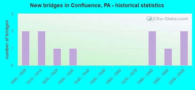
- New bridges - historical statistics
- 21900-1909
- 21910-1919
- 11920-1929
- 11930-1939
- 21980-1989
- 11990-1999
- 22000-2009
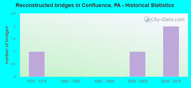
- Reconstructed bridges - Historical Statistics
- 11970-1979
- 01980-1989
- 01990-1999
- 12000-2009
- 22010-2019
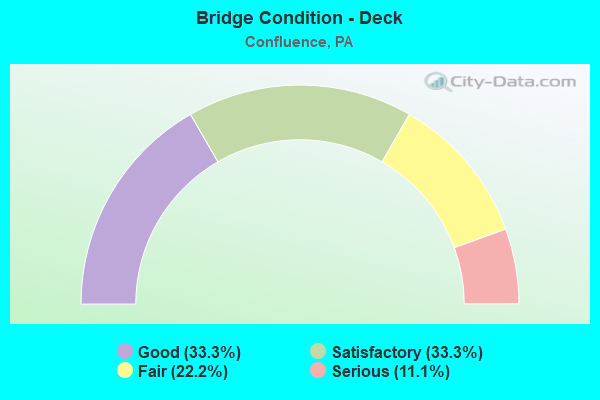
- Bridge Condition - Deck
- 33.3%Good
- 33.3%Satisfactory
- 22.2%Fair
- 11.1%Serious
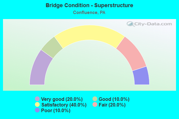
- Bridge Condition - Superstructure
- 20.0%Very good
- 10.0%Good
- 40.0%Satisfactory
- 20.0%Fair
- 10.0%Poor
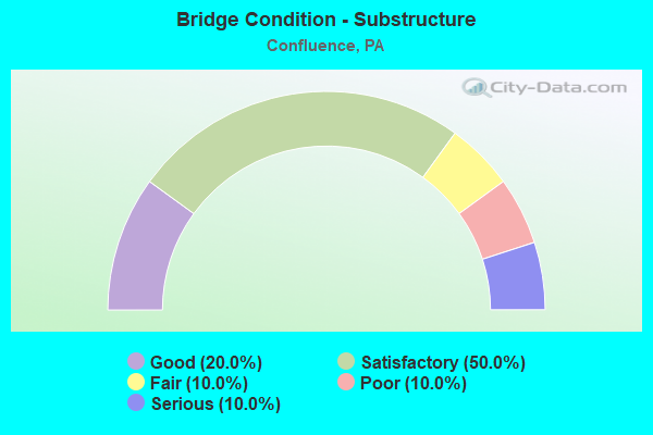
- Bridge Condition - Substructure
- 20.0%Good
- 50.0%Satisfactory
- 10.0%Fair
- 10.0%Poor
- 10.0%Serious
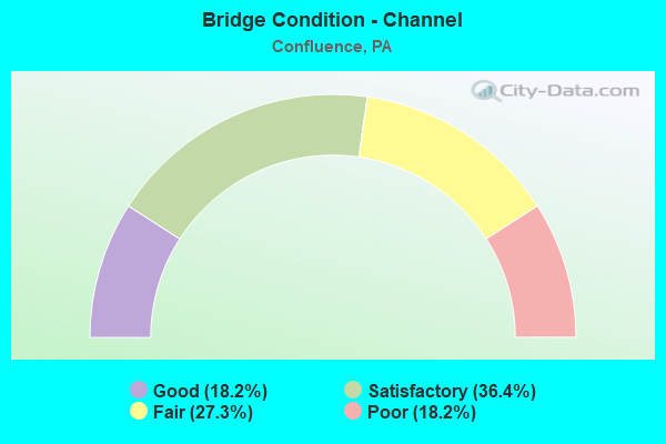
- Bridge Condition - Channel
- 18.2%Good
- 36.4%Satisfactory
- 27.3%Fair
- 18.2%Poor
Find on map >> Show street view
Structure Number: 171, Location: NEAR YOUGH DAM (Lat: 39.803856, Lng: -79.371006), Route carried "on" structure: City street T892, Year Built: 1910, Status: Open, Structure Length: 1.01m (3.31ft), Average Daily Traffic: 25 (year 2006), Truck Traffic: 5%, Average Future Daily Traffic: 35 (year 2026), Design Load: H 20, Features Intersected: HEN RUN, Facility Carried by Structure: FLANIGAN ROAD
Minimum Vertical Clearance: 30+ m (98+ ft), Kilometerpoint: 0.000, Lanes on structure: 1, Owner: County Highway Agency, Approaching Roadway Width: 4.9m (16.1ft), Material/Design: Steel, Design/Construction: Stringer/Multi-beam, Number Of Spans In Main Unit: 1, Length of Maximum Span: 9.4m (30.8ft), Curb-To-Curb Width: 5.2m (17.1ft), Out-to-Out Width: 6.3m (20.7ft)
Condition: Deck: Serious, Superstructure: Fair, Substructure: Satisfactory, Channel: Satisfactory, Operating Rating: 79.8 metric tons, Method Used To Determine Operating Rating: Load Factor (LF), Inventory Rating: 48.1 metric tons, Method Used To Determine Inventory Rating: Load Factor (LF), Structural Evaluation: Somewhat better than minimum adequacy, Deck Geometry: High priority of corrective action, Waterway Adequacy: Better than present minimum criteria, Approach Roadway Alignment: Somewhat better than minimum adequacy, Length Of Structure Improvement: 1.70m (5.58ft), Designated Inspection Frequency: Every 24 months, Inspection Date: September 2021, Bridge Improvement Cost: $7,000, Roadway Improvement Cost: $20,000, Total Project Cost: $91,000, Deck Structure Type: Concrete Cast-file-Place, Wearing Surface/Protective System: Wearing Surface: Bituminous
Find on map >> Show street view
Structure Number: 31431, Location: CONFLUENCE BORO. (Lat: 39.807297, Lng: -79.358325), Route carried "on" structure: State highway 281, Year Built: 1989, Year Reconstructed: 2017, Status: Open, Structure Length: 11.03m (36.19ft), Average Daily Traffic: 1,317 (year 2020), Truck Traffic: 13%, Average Future Daily Traffic: 1,195 (year 2032), Design Load: HS 25 or greater, Features Intersected: CASSELMAN RIVER
Minimum Vertical Clearance: 30+ m (98+ ft), Kilometerpoint: 0.398, Lanes on structure: 2, Owner: State Highway Agency, Approaching Roadway Width: 8.5m (27.9ft), Material/Design: Steel continuous, Design/Construction: Stringer/Multi-beam, Number Of Spans In Main Unit: 3, Length of Maximum Span: 42.1m (138.1ft), Curb or Sidewalk Widths: Left: 1.9m (6.2ft), Right: 0.2m (0.7ft), Curb-To-Curb Width: 8.5m (27.9ft), Out-to-Out Width: 11.0m (36.1ft)
Condition: Deck: Good, Superstructure: Good, Substructure: Good, Channel: Good, Operating Rating: 86.2 metric tons, Method Used To Determine Operating Rating: Load Factor (LF), Inventory Rating: 51.7 metric tons, Method Used To Determine Inventory Rating: Load Factor (LF), Structural Evaluation: Better than present minimum criteria, Deck Geometry: Somewhat better than minimum adequacy, Waterway Adequacy: Superior to present desirable criteria, Approach Roadway Alignment: Better than present minimum criteria, Length Of Structure Improvement: 12.00m (39.37ft), Designated Inspection Frequency: Every 48 months, Inspection Date: May 2019, Deck Structure Type: Concrete Cast-file-Place, Wearing Surface/Protective System: Wearing Surface: Epoxy Overlay, Deck Protection: Epoxy Coated Reinforcing
Find on map >> Show street view
Structure Number: 31433, Location: CONFLUENCE BOROUGH (Lat: 39.813919, Lng: -79.355419), Route carried "on" structure: State highway 281, Year Built: 1935, Year Reconstructed: 2010, Status: Open, Structure Length: 3.90m (12.80ft), Average Daily Traffic: 1,482 (year 2020), Truck Traffic: 4%, Average Future Daily Traffic: 1,875 (year 2032), Design Load: HL 93, Features Intersected: LAUREL HILL CREEK
Minimum Vertical Clearance: 30+ m (98+ ft), Kilometerpoint: 1.395, Lanes on structure: 2, Base Highway Network: Yes, Owner: State Highway Agency, Approaching Roadway Width: 8.5m (27.9ft), Material/Design: Steel continuous, Design/Construction: Stringer/Multi-beam, Number Of Spans In Main Unit: 2, Length of Maximum Span: 19.2m (63.0ft), Curb-To-Curb Width: 9.1m (29.9ft), Out-to-Out Width: 9.8m (32.2ft)
Condition: Deck: Good, Superstructure: Very good, Substructure: Satisfactory, Channel: Satisfactory, Operating Rating: 68.9 metric tons, Method Used To Determine Operating Rating: Load Factor (LF), Inventory Rating: 41.7 metric tons, Method Used To Determine Inventory Rating: Load Factor (LF), Structural Evaluation: Equal to present minimum criteria, Deck Geometry: Somewhat better than minimum adequacy, Waterway Adequacy: Equal to present minimum criteria, Approach Roadway Alignment: Equal to present desirable criteria, Length Of Structure Improvement: 4.70m (15.42ft), Designated Inspection Frequency: Every 24 months, Inspection Date: January 2021, Bridge Improvement Cost: $114,000, Roadway Improvement Cost: $335,000, Total Project Cost: $1,536,000, Deck Structure Type: Concrete Cast-file-Place, Wearing Surface/Protective System: Wearing Surface: Monolithic Concrete, Deck Protection: Epoxy Coated Reinforcing
Find on map >> Show street view
Structure Number: 31676, Location: DRAKETOWN (Lat: 39.852361, Lng: -79.367636), Route carried "on" structure: State highway , Year Built: 1908, Year Reconstructed: 2008, Status: Open, Structure Length: 0.91m (2.99ft), Average Daily Traffic: 213 (year 2020), Truck Traffic: 11%, Average Future Daily Traffic: 202 (year 2032), Design Load: HS 20, Features Intersected: DRAKE RUN, Facility Carried by Structure: SR 3003
Minimum Vertical Clearance: 30+ m (98+ ft), Kilometerpoint: 8.800, Lanes on structure: 2, Owner: State Highway Agency, Approaching Roadway Width: 4.9m (16.1ft), Material/Design: Steel, Design/Construction: Stringer/Multi-beam, Number Of Spans In Main Unit: 1, Length of Maximum Span: 8.2m (26.9ft), Curb-To-Curb Width: 5.8m (19.0ft), Out-to-Out Width: 5.9m (19.4ft)
Condition: Deck: Fair, Superstructure: Poor, Substructure: Poor, Channel: Poor, Operating Rating: 77.1 metric tons, Method Used To Determine Operating Rating: Load Factor (LF), Inventory Rating: 46.3 metric tons, Method Used To Determine Inventory Rating: Load Factor (LF), Structural Evaluation: Meets minimum limits, Deck Geometry: High priority of corrective action, Waterway Adequacy: Better than present minimum criteria, Approach Roadway Alignment: Equal to present desirable criteria, Length Of Structure Improvement: 1.20m (3.94ft), Designated Inspection Frequency: Every 24 months, Inspection Date: January 2021, Bridge Improvement Cost: $45,000, Roadway Improvement Cost: $251,000, Total Project Cost: $608,000, Deck Structure Type: Closed Grating, Wearing Surface/Protective System: Wearing Surface: Monolithic Concrete
Find on map >> Show street view
Structure Number: 31679, Location: CONFLUENCE (Lat: 39.814392, Lng: -79.361839), Route carried "on" structure: State highway , Year Built: 1901, Year Reconstructed: 1982, Status: Open, Structure Length: 4.02m (13.19ft), Average Daily Traffic: 213 (year 2020), Truck Traffic: 11%, Average Future Daily Traffic: 202 (year 2032), Design Load: H 20, Features Intersected: LAUREL HILL CREEK, Facility Carried by Structure: SR 3003
Minimum Vertical Clearance: 30+ m (98+ ft), Kilometerpoint: 13.335, Lanes on structure: 1, Owner: State Highway Agency, Approaching Roadway Width: 5.5m (18.0ft), Material/Design: Steel, Design/Construction: Stringer/Multi-beam, Number Of Spans In Main Unit: 2, Length of Maximum Span: 19.5m (64.0ft), Curb or Sidewalk Widths: Left: 1.0m (3.3ft), Right: 0.2m (0.7ft), Curb-To-Curb Width: 4.5m (14.8ft), Out-to-Out Width: 4.9m (16.1ft)
Condition: Deck: Fair, Superstructure: Fair, Substructure: Fair, Channel: Fair, Operating Rating: 72.6 metric tons, Method Used To Determine Operating Rating: Load Factor (LF), Inventory Rating: 43.5 metric tons, Method Used To Determine Inventory Rating: Load Factor (LF), Structural Evaluation: Somewhat better than minimum adequacy, Deck Geometry: High priority of replacement, Waterway Adequacy: Better than present minimum criteria, Approach Roadway Alignment: Somewhat better than minimum adequacy, Length Of Structure Improvement: 5.00m (16.40ft), Designated Inspection Frequency: Every 24 months, Critical Feature Inspection Frequency: Every 24 months, Inspection Date: October 2020, Critical Feature Inspection Date: October 2020, Bridge Improvement Cost: $121,000, Roadway Improvement Cost: $355,000, Total Project Cost: $1,628,000, Deck Structure Type: Concrete Cast-file-Place, Wearing Surface/Protective System: Wearing Surface: Monolithic Concrete, Deck Protection: Epoxy Coated Reinforcing
Find on map >> Show street view
Structure Number: 31867, Location: 3.5 MI.N.OF CONFLUENCE (Lat: 39.860331, Lng: -79.363878), Route carried "on" structure: City street , Year Built: 1915, Status: Posted for load, Structure Length: 0.79m (2.59ft), Average Daily Traffic: 25 (year 2021), Truck Traffic: 1%, Average Future Daily Traffic: 31 (year 2041), Features Intersected: DRAKE RUN, Facility Carried by Structure: T-390, BACK ROAD
Minimum Vertical Clearance: 30+ m (98+ ft), Kilometerpoint: 0.000, Lanes on structure: 1, Owner: County Highway Agency, Approaching Roadway Width: 3.7m (12.1ft), Material/Design: Concrete, Design/Construction: Arch - Deck, Number Of Spans In Main Unit: 1, Length of Maximum Span: 7.9m (25.9ft), Curb or Sidewalk Widths: Left: 0.2m (0.7ft), Right: 0.2m (0.7ft), Curb-To-Curb Width: 4.5m (14.8ft), Out-to-Out Width: 5.3m (17.4ft)
Condition: Superstructure: Satisfactory, Substructure: Satisfactory, Channel: Fair, Operating Rating: 13.6 metric tons, Method Used To Determine Operating Rating: Field evaluation and documented engineering judgment, Inventory Rating: 12.7 metric tons, Method Used To Determine Inventory Rating: Field evaluation and documented engineering judgment, Structural Evaluation: Meets minimum limits, Deck Geometry: Equal to present minimum criteria, Waterway Adequacy: Equal to present desirable criteria, Approach Roadway Alignment: Equal to present desirable criteria, Bridge Posting: Required (Relationship of Operating Rating to Maximum Legal Load: > 39.9% below), Length Of Structure Improvement: 1.00m (3.28ft), Designated Inspection Frequency: Every 24 months, Other Special Inspection Frequency: Every 12 months, Inspection Date: September 2020, Other Special Inspection Date: September 2021, Bridge Improvement Cost: $44,000, Roadway Improvement Cost: $264,000, Total Project Cost: $589,000
Find on map >> Show street view
Structure Number: 31868, Location: 3.7 MI.N.OF CONFLUENCE (Lat: 39.862833, Lng: -79.362450), Route carried "on" structure: City street , Year Built: 1922, Status: Posted for load, Structure Length: 0.70m (2.30ft), Average Daily Traffic: 25 (year 2021), Truck Traffic: 1%, Average Future Daily Traffic: 31 (year 2041), Features Intersected: LITTLE GLADE RUN, Facility Carried by Structure: T-390, BACK ROAD
Minimum Vertical Clearance: 30+ m (98+ ft), Kilometerpoint: 0.000, Lanes on structure: 1, Owner: County Highway Agency, Approaching Roadway Width: 3.4m (11.2ft), Skew: 3 degrees, Material/Design: Concrete, Design/Construction: Tee Beam, Number Of Spans In Main Unit: 1, Length of Maximum Span: 6.7m (22.0ft), Curb or Sidewalk Widths: Left: 0.2m (0.7ft), Right: 0.2m (0.7ft), Curb-To-Curb Width: 4.1m (13.5ft), Out-to-Out Width: 4.8m (15.7ft)
Condition: Deck: Satisfactory, Superstructure: Satisfactory, Substructure: Serious, Channel: Poor, Operating Rating: 17.2 metric tons, Method Used To Determine Operating Rating: Field evaluation and documented engineering judgment, Inventory Rating: 16.3 metric tons, Method Used To Determine Inventory Rating: Field evaluation and documented engineering judgment, Structural Evaluation: High priority of corrective action, Deck Geometry: Somewhat better than minimum adequacy, Waterway Adequacy: Better than present minimum criteria, Approach Roadway Alignment: Better than present minimum criteria, Bridge Posting: Required (Relationship of Operating Rating to Maximum Legal Load: > 39.9% below), Length Of Structure Improvement: 0.90m (2.95ft), Designated Inspection Frequency: Every 24 months, Other Special Inspection Frequency: Every 12 months, Inspection Date: September 2020, Other Special Inspection Date: September 2021, Bridge Improvement Cost: $36,000, Roadway Improvement Cost: $206,000, Total Project Cost: $483,000, Deck Structure Type: Concrete Cast-file-Place, Wearing Surface/Protective System: Wearing Surface: Monolithic Concrete
Find on map >> Show street view
Structure Number: 4009, Location: CONFLUENCE BRIDGE (Lat: 39.808333, Lng: -79.366667), Route carried "on" structure: State highway 281, Year Built: 1998, Status: Open, Structure Length: 11.34m (37.20ft), Average Daily Traffic: 1,317 (year 2020), Truck Traffic: 13%, Average Future Daily Traffic: 1,194 (year 2042), Design Load: HS 25 or greater, Features Intersected: YOUGHIOGHENY RIVER
Minimum Vertical Clearance: 30+ m (98+ ft), Kilometerpoint: 14.286, Lanes on structure: 2, Owner: State Highway Agency, Approaching Roadway Width: 10.4m (34.1ft), Skew: 2 degrees, Material/Design: Prestressed concrete continuous, Design/Construction: Stringer/Multi-beam, Number Of Spans In Main Unit: 3, Length of Maximum Span: 37.8m (124.0ft), Curb or Sidewalk Widths: Left: 0.2m (0.7ft), Right: 3.0m (9.8ft), Curb-To-Curb Width: 10.4m (34.1ft), Out-to-Out Width: 14.8m (48.6ft)
Condition: Deck: Good, Superstructure: Satisfactory, Substructure: Good, Channel: Good, Inventory Rating: 60.8 metric tons, Method Used To Determine Inventory Rating: Load Factor (LF), Structural Evaluation: Equal to present minimum criteria, Deck Geometry: Equal to present minimum criteria, Waterway Adequacy: Superior to present desirable criteria, Approach Roadway Alignment: Equal to present desirable criteria, Length Of Structure Improvement: 12.30m (40.35ft), Designated Inspection Frequency: Every 48 months, Inspection Date: July 2020, Deck Structure Type: Concrete Cast-file-Place, Wearing Surface/Protective System: Wearing Surface: Monolithic Concrete, Deck Protection: Epoxy Coated Reinforcing
Find on map >> Show street view
Structure Number: 42048, Location: DRAKETOWN (Lat: 39.848578, Lng: -79.370597), Route carried "on" structure: State highway , Year Built: 2003, Status: Open, Structure Length: 2.01m (6.59ft), Average Daily Traffic: 213 (year 2020), Truck Traffic: 11%, Average Future Daily Traffic: 202 (year 2032), Design Load: HS 25 or greater, Features Intersected: DRAKE RUN, Facility Carried by Structure: SR 3003
Minimum Vertical Clearance: 30+ m (98+ ft), Kilometerpoint: 9.308, Lanes on structure: 2, Owner: State Highway Agency, Approaching Roadway Width: 8.5m (27.9ft), Skew: 4 degrees, Material/Design: Prestressed concrete, Design/Construction: Box Beam or Girders - Single/Spread, Number Of Spans In Main Unit: 1, Length of Maximum Span: 19.5m (64.0ft), Curb or Sidewalk Widths: Left: 0.2m (0.7ft), Right: 0.2m (0.7ft), Curb-To-Curb Width: 8.5m (27.9ft), Out-to-Out Width: 9.4m (30.8ft)
Condition: Deck: Satisfactory, Superstructure: Very good, Substructure: Satisfactory, Channel: Satisfactory, Operating Rating: 83.5 metric tons, Method Used To Determine Operating Rating: Load Factor (LF), Inventory Rating: 43.5 metric tons, Method Used To Determine Inventory Rating: Load Factor (LF), Structural Evaluation: Equal to present minimum criteria, Deck Geometry: Equal to present minimum criteria, Waterway Adequacy: Equal to present desirable criteria, Approach Roadway Alignment: Equal to present desirable criteria, Length Of Structure Improvement: 2.70m (8.86ft), Designated Inspection Frequency: Every 48 months, Inspection Date: January 2021, Deck Structure Type: Concrete Cast-file-Place, Wearing Surface/Protective System: Wearing Surface: Monolithic Concrete, Deck Protection: Epoxy Coated Reinforcing
Find on map >> Show street view
Structure Number: 46052, Location: YOUGH BIKE TRAIL PARKING (Lat: 39.824300, Lng: -79.379697), Route carried "on" structure: ServiceState lands road , Year Built: 2009, Status: Open, Structure Length: 0.73m (2.40ft), Average Daily Traffic: 50 (year 2018), Average Future Daily Traffic: 60 (year 2028), Design Load: HS 20, Features Intersected: RAMCAT RUN, Facility Carried by Structure: RAMCAT ROAD
Minimum Vertical Clearance: 30+ m (98+ ft), Kilometerpoint: 0.000, Lanes on structure: 2, Owner: State Park, Forest, or Reservation Agency, Approaching Roadway Width: 4.9m (16.1ft), Material/Design: Concrete, Design/Construction: Culvert, Number Of Spans In Main Unit: 1, Length of Maximum Span: 6.7m (22.0ft), Curb-To-Curb Width: 5.5m (18.0ft), Out-to-Out Width: 6.7m (22.0ft)
Condition: Channel: Satisfactory, Culverts: Good, Operating Rating: 75.3 metric tons, Method Used To Determine Operating Rating: Load Factor (LF), Inventory Rating: 45.4 metric tons, Method Used To Determine Inventory Rating: Load Factor (LF), Structural Evaluation: Better than present minimum criteria, Deck Geometry: Meets minimum limits, Waterway Adequacy: Superior to present desirable criteria, Approach Roadway Alignment: Equal to present desirable criteria, Length Of Structure Improvement: 0.80m (2.62ft), Designated Inspection Frequency: Every 24 months, Inspection Date: July 2020
Find on map >> Show street view
Structure Number: 2140001P, Location: YOUGH LAKE CAMPGROUND (Lat: 39.773028, Lng: -79.403194), Route carried "on" structure: Spur Federal lands road , Year Built: 1989, Status: Open, Structure Length: 2.55m (8.37ft), Average Daily Traffic: 50 (year 2020), Truck Traffic: 1%, Average Future Daily Traffic: 60 (year 2036), Design Load: HL 93, Features Intersected: TUB RUN CREEK, Facility Carried by Structure: CAMPGROUND ROAD
Minimum Vertical Clearance: 30+ m (98+ ft), Kilometerpoint: 0.000, Lanes on structure: 2, Owner: Corps of Engineers (Civil), Approaching Roadway Width: 5.4m (17.7ft), Skew: 3 degrees, Material/Design: Prestressed concrete, Design/Construction: Box Beam or Girders - Multiple, Number Of Spans In Main Unit: 3, Length of Maximum Span: 8.1m (26.6ft), Curb or Sidewalk Widths: Left: 0.2m (0.7ft), Right: 0.7m (2.3ft), Curb-To-Curb Width: 6.3m (20.7ft), Out-to-Out Width: 7.4m (24.3ft)
Condition: Deck: Satisfactory, Superstructure: Satisfactory, Substructure: Satisfactory, Channel: Fair, Operating Rating: 66.7 metric tons, Method Used To Determine Operating Rating: Load and Resistance Factor Rating (LRFR) rating reported by rating factor(RF) method using HL-93 loadings, Inventory Rating: 51.5 metric tons, Method Used To Determine Inventory Rating: Load and Resistance Factor Rating (LRFR) rating reported by rating factor(RF) method using HL-93 loadings, Structural Evaluation: Equal to present minimum criteria, Deck Geometry: Somewhat better than minimum adequacy, Waterway Adequacy: Equal to present minimum criteria, Approach Roadway Alignment: Equal to present minimum criteria, Length Of Structure Improvement: 3.31m (10.86ft), Designated Inspection Frequency: Every 24 months, Inspection Date: June 2020, Bridge Improvement Cost: $198,000, Roadway Improvement Cost: $16,000, Total Project Cost: $214,000 ( Estimate for 2016), Deck Structure Type: Concrete Cast-file-Place, Wearing Surface/Protective System: Wearing Surface: Monolithic Concrete, Deck Protection: Epoxy Coated Reinforcing