Bridge Statistics for Conneaut Lakeshore, Pennsylvania (PA)
Condition, Traffic, Stress, Structural Evaluation, Project Costs
- National Bridge Inventory (NBI) Statistics
- 11Number of bridges
- 52ft / 15.6mTotal length
- $188,000Total costs
- 35,187Total average daily traffic
- 2,148Total average daily truck traffic
- 49,184Total future (year 2032) average daily traffic
- National Bridge Inventory (NBI) Registered Bridges for Conneaut Lakeshore
- No street view available for this location
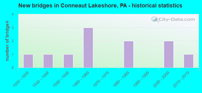
- New bridges - historical statistics
- 11930-1939
- 11940-1949
- 11950-1959
- 31960-1969
- 21980-1989
- 22000-2009
- 12010-2019


- Bridge Condition - Deck
- 14.3%Very good
- 14.3%Good
- 42.9%Satisfactory
- 14.3%Fair
- 14.3%Poor

- Bridge Condition - Superstructure
- 14.3%Excellent
- 28.6%Good
- 14.3%Satisfactory
- 42.9%Fair

- Bridge Condition - Substructure
- 14.3%Excellent
- 14.3%Good
- 14.3%Satisfactory
- 42.9%Fair
- 14.3%Poor

- Bridge Condition - Channel
- 20.0%Good
- 40.0%Satisfactory
- 10.0%Fair
- 30.0%Poor

- Bridge Condition - Culverts
- 25.0%Very good
- 25.0%Satisfactory
- 25.0%Fair
- 25.0%Poor
Find on map >> Show street view
Structure Number: 12878, Location: VERNON TOWNSHIP (Lat: 41.614592, Lng: -80.251050), Route carried "on" structure: US 6, Year Built: 1939, Year Reconstructed: 1959, Status: Open, Structure Length: 2.13m (6.99ft), Average Daily Traffic: 10,904 (year 2020), Truck Traffic: 5%, Average Future Daily Traffic: 15,901 (year 2032), Design Load: HS 20, Features Intersected: OVER WATSON RUN
Minimum Vertical Clearance: 30+ m (98+ ft), Kilometerpoint: 27.777, Lanes on structure: 4, Base Highway Network: Yes, Owner: State Highway Agency, Approaching Roadway Width: 19.5m (64.0ft), Skew: 4 degrees, Material/Design: Concrete, Design/Construction: Tee Beam, Number Of Spans In Main Unit: 2, Length of Maximum Span: 9.8m (32.2ft), Curb-To-Curb Width: 19.6m (64.3ft), Out-to-Out Width: 21.2m (69.6ft)
Condition: Deck: Poor, Superstructure: Fair, Substructure: Poor, Channel: Poor, Operating Rating: 68.9 metric tons, Method Used To Determine Operating Rating: Load Factor (LF), Inventory Rating: 40.8 metric tons, Method Used To Determine Inventory Rating: Load Factor (LF), Structural Evaluation: Meets minimum limits, Deck Geometry: Better than present minimum criteria, Waterway Adequacy: Equal to present minimum criteria, Approach Roadway Alignment: Equal to present desirable criteria, Length Of Structure Improvement: 2.80m (9.19ft), Designated Inspection Frequency: Every 24 months, Inspection Date: September 2021, Wearing Surface/Protective System: Wearing Surface: Bituminous, Membrane: Preformed Fabric
Find on map >> Show street view
Structure Number: 13085, Location: SADSBURY TOWNSHIP (Lat: 41.605481, Lng: -80.392406), Route carried "on" structure: State highway 285, Year Built: 1960, Status: Open, Structure Length: 2.47m (8.10ft), Average Daily Traffic: 2,555 (year 2022), Truck Traffic: 8%, Average Future Daily Traffic: 3,080 (year 2032), Design Load: HS 20, Features Intersected: OVER SWAMP
Minimum Vertical Clearance: 30+ m (98+ ft), Kilometerpoint: 10.614, Lanes on structure: 2, Base Highway Network: Yes, Owner: State Highway Agency, Approaching Roadway Width: 6.7m (22.0ft), Material/Design: Prestressed concrete, Design/Construction: Box Beam or Girders - Multiple, Number Of Spans In Main Unit: 1, Length of Maximum Span: 23.8m (78.1ft), Curb-To-Curb Width: 12.2m (40.0ft), Out-to-Out Width: 14.0m (45.9ft)
Condition: Deck: Good, Superstructure: Good, Substructure: Good, Channel: Good, Inventory Rating: 47.2 metric tons, Method Used To Determine Inventory Rating: Load Factor (LF), Structural Evaluation: Better than present minimum criteria, Deck Geometry: Equal to present minimum criteria, Waterway Adequacy: Equal to present minimum criteria, Approach Roadway Alignment: Equal to present desirable criteria, Length Of Structure Improvement: 3.20m (10.50ft), Designated Inspection Frequency: Every 48 months, Inspection Date: March 2021, Deck Structure Type: Concrete Cast-file-Place, Wearing Surface/Protective System: Wearing Surface: Bituminous, Membrane: Preformed Fabric
Find on map >> Show street view
Structure Number: 13088, Location: GREENWOOD TOWNSHIP (Lat: 41.570175, Lng: -80.268850), Route carried "on" structure: State highway 285, Year Built: 1947, Status: Open, Structure Length: 0.79m (2.59ft), Average Daily Traffic: 2,016 (year 2021), Truck Traffic: 13%, Average Future Daily Traffic: 1,960 (year 2032), Design Load: H 20, Features Intersected: OVER MCMICHAEL RUN
Minimum Vertical Clearance: 30+ m (98+ ft), Kilometerpoint: 22.772, Lanes on structure: 2, Base Highway Network: Yes, Owner: State Highway Agency, Approaching Roadway Width: 9.1m (29.9ft), Skew: 1 degrees, Material/Design: Concrete, Design/Construction: Culvert, Number Of Spans In Main Unit: 1, Length of Maximum Span: 7.9m (25.9ft)
Condition: Channel: Satisfactory, Culverts: Fair, Operating Rating: 77.1 metric tons, Method Used To Determine Operating Rating: Allowable Stress (AS), Inventory Rating: 46.3 metric tons, Method Used To Determine Inventory Rating: Allowable Stress (AS), Structural Evaluation: Somewhat better than minimum adequacy, Waterway Adequacy: Equal to present minimum criteria, Approach Roadway Alignment: Equal to present desirable criteria, Length Of Structure Improvement: 1.40m (4.59ft), Designated Inspection Frequency: Every 24 months, Inspection Date: May 2020, Bridge Improvement Cost: $14,000, Roadway Improvement Cost: $41,000, Total Project Cost: $188,000
Find on map >> Show street view
Structure Number: 13132, Location: SADSBURY TOWNSHIP (Lat: 41.632317, Lng: -80.323294), Route carried "on" structure: State highway 618, Year Built: 1980, Status: Open, Structure Length: 0.61m (2.00ft), Average Daily Traffic: 1,864 (year 2021), Truck Traffic: 7%, Average Future Daily Traffic: 1,821 (year 2032), Design Load: H 15, Features Intersected: OVER CONNEAUT LAKE TRIB
Minimum Vertical Clearance: 30+ m (98+ ft), Kilometerpoint: 2.865, Lanes on structure: 2, Owner: State Highway Agency, Approaching Roadway Width: 9.1m (29.9ft), Material/Design: Steel, Design/Construction: Culvert, Number Of Spans In Main Unit: 3, Length of Maximum Span: 1.5m (4.9ft)
Condition: Channel: Satisfactory, Culverts: Poor, Operating Rating: 49.0 metric tons, Method Used To Determine Operating Rating: Field evaluation and documented engineering judgment, Inventory Rating: 32.7 metric tons, Method Used To Determine Inventory Rating: Field evaluation and documented engineering judgment, Structural Evaluation: Meets minimum limits, Waterway Adequacy: Superior to present desirable criteria, Approach Roadway Alignment: Equal to present desirable criteria, Length Of Structure Improvement: 1.20m (3.94ft), Designated Inspection Frequency: Every 24 months, Other Special Inspection Frequency: Every 12 months, Inspection Date: March 2020, Other Special Inspection Date: March 2021
Find on map >> Show street view
Structure Number: 13314, Location: VERNON TOWNSHIP (Lat: 41.653897, Lng: -80.258369), Route carried "on" structure: State highway , Year Built: 1952, Status: Open, Structure Length: 0.98m (3.22ft), Average Daily Traffic: 2,992 (year 2022), Truck Traffic: 7%, Average Future Daily Traffic: 5,389 (year 2032), Design Load: H 20, Features Intersected: OVER WATSON RUN, Facility Carried by Structure: SR 3016,HARMONSBG
Minimum Vertical Clearance: 30+ m (98+ ft), Kilometerpoint: 12.297, Lanes on structure: 2, Owner: State Highway Agency, Approaching Roadway Width: 7.9m (25.9ft), Material/Design: Concrete, Design/Construction: Tee Beam, Number Of Spans In Main Unit: 1, Length of Maximum Span: 9.1m (29.9ft), Curb-To-Curb Width: 9.8m (32.2ft), Out-to-Out Width: 10.4m (34.1ft)
Condition: Deck: Satisfactory, Superstructure: Fair, Substructure: Fair, Channel: Poor, Operating Rating: 72.6 metric tons, Method Used To Determine Operating Rating: Load Factor (LF), Inventory Rating: 42.6 metric tons, Method Used To Determine Inventory Rating: Load Factor (LF), Structural Evaluation: Somewhat better than minimum adequacy, Deck Geometry: Meets minimum limits, Waterway Adequacy: Equal to present minimum criteria, Approach Roadway Alignment: Equal to present desirable criteria, Length Of Structure Improvement: 1.60m (5.25ft), Designated Inspection Frequency: Every 23 months, Inspection Date: April 2020, Wearing Surface/Protective System: Wearing Surface: Bituminous
Find on map >> Show street view
Structure Number: 13349, Location: VERNON TOWNSHIP (Lat: 41.634194, Lng: -80.260597), Route carried "on" structure: State highway , Year Built: 1963, Status: Open, Structure Length: 1.46m (4.79ft), Average Daily Traffic: 424 (year 2017), Truck Traffic: 9%, Average Future Daily Traffic: 391 (year 2032), Design Load: HS 20, Features Intersected: OVER WATSON RUN, Facility Carried by Structure: SR 4007,WATSON RUN
Minimum Vertical Clearance: 30+ m (98+ ft), Kilometerpoint: 0.000, Lanes on structure: 2, Owner: State Highway Agency, Approaching Roadway Width: 6.7m (22.0ft), Skew: 2 degrees, Material/Design: Prestressed concrete, Design/Construction: Box Beam or Girders - Single/Spread, Number Of Spans In Main Unit: 1, Length of Maximum Span: 14.0m (45.9ft), Curb or Sidewalk Widths: Left: 0.5m (1.6ft), Right: 0.5m (1.6ft), Curb-To-Curb Width: 9.1m (29.9ft), Out-to-Out Width: 10.8m (35.4ft)
Condition: Deck: Satisfactory, Superstructure: Good, Substructure: Fair, Channel: Poor, Operating Rating: 89.8 metric tons, Method Used To Determine Operating Rating: Load Factor (LF), Inventory Rating: 34.5 metric tons, Method Used To Determine Inventory Rating: Load Factor (LF), Structural Evaluation: Somewhat better than minimum adequacy, Deck Geometry: Equal to present minimum criteria, Waterway Adequacy: Better than present minimum criteria, Approach Roadway Alignment: Equal to present desirable criteria, Length Of Structure Improvement: 1.50m (4.92ft), Designated Inspection Frequency: Every 24 months, Inspection Date: March 2020, Deck Structure Type: Concrete Cast-file-Place, Wearing Surface/Protective System: Wearing Surface: Bituminous, Membrane: Preformed Fabric
Find on map >> Show street view
Structure Number: 1335, Location: VERNON TOWNSHIP (Lat: 41.649000, Lng: -80.260606), Route carried "on" structure: State highway , Year Built: 1963, Status: Open, Structure Length: 0.79m (2.59ft), Average Daily Traffic: 424 (year 2017), Truck Traffic: 9%, Average Future Daily Traffic: 391 (year 2032), Design Load: HS 20, Features Intersected: OVER WATSON RUN, Facility Carried by Structure: SR 4007,WATSON RUN
Minimum Vertical Clearance: 30+ m (98+ ft), Kilometerpoint: 0.014, Lanes on structure: 2, Owner: State Highway Agency, Approaching Roadway Width: 6.1m (20.0ft), Skew: 1 degrees, Material/Design: Concrete, Design/Construction: Slab, Number Of Spans In Main Unit: 1, Length of Maximum Span: 7.3m (24.0ft), Curb or Sidewalk Widths: Left: 0.5m (1.6ft), Right: 0.5m (1.6ft), Curb-To-Curb Width: 9.1m (29.9ft), Out-to-Out Width: 10.8m (35.4ft)
Condition: Deck: Satisfactory, Superstructure: Satisfactory, Substructure: Fair, Channel: Fair, Operating Rating: 57.2 metric tons, Method Used To Determine Operating Rating: Load Factor (LF), Inventory Rating: 32.7 metric tons, Method Used To Determine Inventory Rating: Load Factor (LF), Structural Evaluation: Somewhat better than minimum adequacy, Deck Geometry: Equal to present minimum criteria, Waterway Adequacy: Better than present minimum criteria, Approach Roadway Alignment: Equal to present desirable criteria, Length Of Structure Improvement: 0.80m (2.62ft), Designated Inspection Frequency: Every 24 months, Inspection Date: March 2020, Wearing Surface/Protective System: Wearing Surface: Bituminous, Membrane: Preformed Fabric
Find on map >> Show street view
Structure Number: 13438, Location: 2.5 MI. SE. CONNEAUT LK. (Lat: 41.587233, Lng: -80.265147), Route carried "on" structure: City street 7211, Year Built: 1988, Status: Open, Structure Length: 0.70m (2.30ft), Average Daily Traffic: 250 (year 2020), Truck Traffic: 1%, Average Future Daily Traffic: 350 (year 2040), Features Intersected: OVER CONNEAUT OUTLET CK., Facility Carried by Structure: T-387,BROWN HILL
Minimum Vertical Clearance: 30+ m (98+ ft), Kilometerpoint: 0.000, Lanes on structure: 2, Owner: Town or Township Highway Agency, Approaching Roadway Width: 3.7m (12.1ft), Material/Design: Steel, Design/Construction: Culvert, Number Of Spans In Main Unit: 3, Length of Maximum Span: 7.0m (23.0ft)
Condition: Channel: Satisfactory, Culverts: Satisfactory, Operating Rating: 49.0 metric tons, Method Used To Determine Operating Rating: Field evaluation and documented engineering judgment, Inventory Rating: 32.7 metric tons, Method Used To Determine Inventory Rating: Field evaluation and documented engineering judgment, Structural Evaluation: Equal to present minimum criteria, Waterway Adequacy: Equal to present minimum criteria, Approach Roadway Alignment: Equal to present desirable criteria, Length Of Structure Improvement: 0.90m (2.95ft), Designated Inspection Frequency: Every 24 months, Inspection Date: May 2020
Find on map >> Show street view
Structure Number: 40956, Location: SADSBURY TOWNSHIP (Lat: 41.627458, Lng: -80.376489), Route carried "on" structure: US 6, Year Built: 2000, Status: Open, Structure Length: 3.78m (12.40ft), Average Daily Traffic: 2,454 (year 2022), Truck Traffic: 7%, Average Future Daily Traffic: 3,227 (year 2032), Design Load: H 15, Features Intersected: OVER B.& L.E. RAILROAD
Minimum Vertical Clearance: 30+ m (98+ ft), Kilometerpoint: 16.435, Lanes on structure: 2, Owner: State Highway Agency, Approaching Roadway Width: 12.2m (40.0ft), Material/Design: Prestressed concrete, Design/Construction: Stringer/Multi-beam, Number Of Spans In Main Unit: 1, Length of Maximum Span: 37.2m (122.0ft), Curb or Sidewalk Widths: Left: 0.1m (0.3ft), Right: 0.1m (0.3ft), Curb-To-Curb Width: 12.0m (39.4ft), Out-to-Out Width: 13.0m (42.7ft)
Condition: Deck: Very good, Superstructure: Excellent, Substructure: Excellent, Inventory Rating: 21.8 metric tons, Method Used To Determine Inventory Rating: Load Factor (LF), Structural Evaluation: Somewhat better than minimum adequacy, Deck Geometry: Somewhat better than minimum adequacy, Underclear: High priority of corrective action, Approach Roadway Alignment: Equal to present desirable criteria, Length Of Structure Improvement: 4.70m (15.42ft), Designated Inspection Frequency: Every 24 months, Inspection Date: September 2020, Deck Structure Type: Concrete Cast-file-Place, Wearing Surface/Protective System: Wearing Surface: Monolithic Concrete, Deck Protection: Epoxy Coated Reinforcing
Find on map >> Show street view
Structure Number: 41843, Location: .1 MI.W.OF SR-4007 (Lat: 41.637869, Lng: -80.262328), Route carried "on" structure: City street 7230, Year Built: 2002, Status: Open, Structure Length: 1.13m (3.71ft), Average Daily Traffic: 400 (year 2020), Truck Traffic: 1%, Average Future Daily Traffic: 560 (year 2040), Design Load: HS 25 or greater, Features Intersected: OVER WATSON RUN, Facility Carried by Structure: T-487, MIDDLE ROAD
Minimum Vertical Clearance: 30+ m (98+ ft), Kilometerpoint: 0.000, Lanes on structure: 2, Owner: Town or Township Highway Agency, Approaching Roadway Width: 6.4m (21.0ft), Material/Design: Prestressed concrete, Design/Construction: Box Beam or Girders - Multiple, Number Of Spans In Main Unit: 1, Length of Maximum Span: 10.7m (35.1ft), Curb or Sidewalk Widths: Left: 0.2m (0.7ft), Right: 0.2m (0.7ft), Curb-To-Curb Width: 7.7m (25.3ft), Out-to-Out Width: 8.6m (28.2ft)
Condition: Deck: Fair, Superstructure: Fair, Substructure: Satisfactory, Channel: Satisfactory, Operating Rating: 62.6 metric tons, Method Used To Determine Operating Rating: Load Factor (LF), Inventory Rating: 37.2 metric tons, Method Used To Determine Inventory Rating: Load Factor (LF), Structural Evaluation: Somewhat better than minimum adequacy, Deck Geometry: Somewhat better than minimum adequacy, Waterway Adequacy: Better than present minimum criteria, Approach Roadway Alignment: Equal to present desirable criteria, Length Of Structure Improvement: 1.70m (5.58ft), Designated Inspection Frequency: Every 24 months, Inspection Date: October 2020, Deck Structure Type: Other, Wearing Surface/Protective System: Wearing Surface: Bituminous, Membrane: Preformed Fabric, Deck Protection: Epoxy Coated Reinforcing
Find on map >> Show street view
Structure Number: 53527, Location: VERNON TOWNSHIP (Lat: 41.615211, Lng: -80.237681), Route carried "on" structure: US 6, Year Built: 2016, Status: Open, Structure Length: 0.79m (2.59ft), Average Daily Traffic: 10,904 (year 2020), Truck Traffic: 5%, Average Future Daily Traffic: 16,114 (year 2037), Design Load: HL 93, Features Intersected: Watson Run
Minimum Vertical Clearance: 30+ m (98+ ft), Kilometerpoint: 29.089, Lanes on structure: 5, Base Highway Network: Yes, Owner: State Highway Agency, Maintenance Responsibility: Private, Approaching Roadway Width: 21.6m (70.9ft), Material/Design: Concrete, Design/Construction: Culvert, Number Of Spans In Main Unit: 1, Length of Maximum Span: 7.3m (24.0ft), Curb-To-Curb Width: 21.6m (70.9ft), Out-to-Out Width: 23.0m (75.5ft)
Condition: Channel: Good, Culverts: Very good, Operating Rating: 63.2 metric tons, Method Used To Determine Operating Rating: Assigned ratings based on Load and Resistance Factor Design (LRFD) reported by rating factor (RF) using HL93 loadings, Inventory Rating: 39.5 metric tons, Method Used To Determine Inventory Rating: Assigned ratings based on Load and Resistance Factor Design (LRFD) reported by rating factor (RF) using HL93 loadings, Structural Evaluation: Equal to present desirable criteria, Deck Geometry: Somewhat better than minimum adequacy, Waterway Adequacy: Superior to present desirable criteria, Approach Roadway Alignment: Equal to present desirable criteria, Designated Inspection Frequency: Every 24 months, Inspection Date: April 2020, Wearing Surface/Protective System: Wearing Surface: Bituminous, Membrane: Preformed Fabric