Bridge Statistics for Conover, North Carolina (NC)
Condition, Traffic, Stress, Structural Evaluation, Project Costs
- National Bridge Inventory (NBI) Statistics
- 42Number of bridges
- 335ft / 102mTotal length
- 476,525Total average daily traffic
- 63,772Total average daily truck traffic
- National Bridge Inventory (NBI) Registered Bridges for Conover
- No street view available for this location
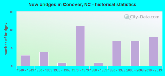
- New bridges - historical statistics
- 31940-1949
- 41950-1959
- 11960-1969
- 111970-1979
- 11980-1989
- 71990-1999
- 72000-2009
- 82010-2019
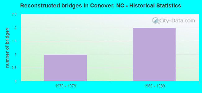
- Reconstructed bridges - Historical Statistics
- 11970-1979
- 21980-1989
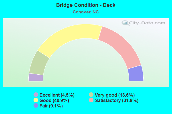
- Bridge Condition - Deck
- 4.5%Excellent
- 13.6%Very good
- 40.9%Good
- 31.8%Satisfactory
- 9.1%Fair
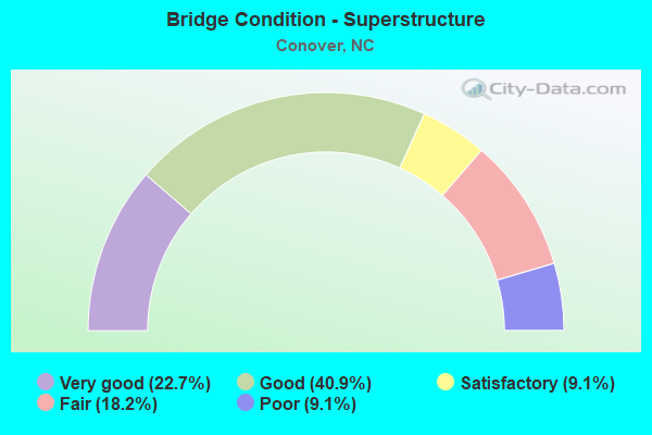
- Bridge Condition - Superstructure
- 22.7%Very good
- 40.9%Good
- 9.1%Satisfactory
- 18.2%Fair
- 9.1%Poor
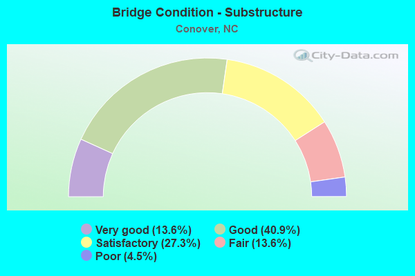
- Bridge Condition - Substructure
- 13.6%Very good
- 40.9%Good
- 27.3%Satisfactory
- 13.6%Fair
- 4.5%Poor
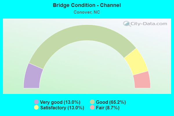
- Bridge Condition - Channel
- 13.0%Very good
- 65.2%Good
- 13.0%Satisfactory
- 8.7%Fair
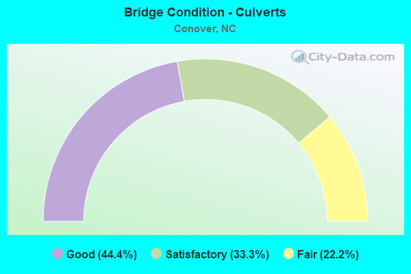
- Bridge Condition - Culverts
- 44.4%Good
- 33.3%Satisfactory
- 22.2%Fair
Find on map >> Show street view
Structure Number: 350004, Location: 0.05 MI. S. JCT. SR1711 (Lat: 35.742228, Lng: -81.159850), Route carried "on" structure: State highway 1709, Year Built: 1970, Status: Open, Structure Length: 4.11m (13.48ft), Average Daily Traffic: 2,400 (year 2019), Truck Traffic: 6%, Average Future Daily Traffic: 4,800 (year 2040), Design Load: HS 15, Features Intersected: LYLE CREEK
Minimum Vertical Clearance: 30+ m (98+ ft), Kilometerpoint: 0.000, Lanes on structure: 2, Owner: State Highway Agency, Approaching Roadway Width: 7.6m (24.9ft), Material/Design: Prestressed concrete, Design/Construction: Slab, Number Of Spans In Main Unit: 3, Length of Maximum Span: 13.4m (44.0ft), Curb-To-Curb Width: 7.2m (23.6ft), Out-to-Out Width: 7.6m (24.9ft)
Condition: Deck: Fair, Superstructure: Fair, Substructure: Fair, Channel: Good, Operating Rating: 48.9 metric tons, Method Used To Determine Operating Rating: Load Factor (LF), Inventory Rating: 29.0 metric tons, Method Used To Determine Inventory Rating: Load Factor (LF), Structural Evaluation: Somewhat better than minimum adequacy, Deck Geometry: High priority of replacement, Waterway Adequacy: Better than present minimum criteria, Approach Roadway Alignment: Equal to present minimum criteria, Designated Inspection Frequency: Every 24 months, Inspection Date: January 2021, Deck Structure Type: Concrete Precast Panels, Wearing Surface/Protective System: Wearing Surface: Bituminous
Find on map >> Show street view
Structure Number: 350007, Location: 0.1 MI. E. JCT. NC16 (Lat: 35.731939, Lng: -81.193219), Route carried "on" structure: State highway 1712, Year Built: 1973, Status: Posted for load, Structure Length: 2.31m (7.58ft), Average Daily Traffic: 1,500 (year 2017), Truck Traffic: 7%, Average Future Daily Traffic: 3,000 (year 2040), Features Intersected: UT TO LYLE CREEK
Minimum Vertical Clearance: 30+ m (98+ ft), Kilometerpoint: 0.000, Lanes on structure: 2, Owner: State Highway Agency, Approaching Roadway Width: 6.0m (19.7ft), Material/Design: Steel, Design/Construction: Stringer/Multi-beam, Number Of Spans In Main Unit: 3, Length of Maximum Span: 7.6m (24.9ft), Curb or Sidewalk Widths: Left: 0.1m (0.3ft), Right: 0.1m (0.3ft), Curb-To-Curb Width: 7.4m (24.3ft), Out-to-Out Width: 7.7m (25.3ft)
Condition: Deck: Good, Superstructure: Poor, Substructure: Satisfactory, Channel: Good, Operating Rating: 21.7 metric tons, Method Used To Determine Operating Rating: Load Factor (LF), Inventory Rating: 12.7 metric tons, Method Used To Determine Inventory Rating: Load Factor (LF), Structural Evaluation: Meets minimum limits, Deck Geometry: Meets minimum limits, Waterway Adequacy: Better than present minimum criteria, Approach Roadway Alignment: Equal to present desirable criteria, Bridge Posting: Required (Relationship of Operating Rating to Maximum Legal Load: > 39.9% below), Designated Inspection Frequency: Every 24 months, Inspection Date: January 2021, Deck Structure Type: Wood or Timber, Wearing Surface/Protective System: Wearing Surface: Bituminous
Find on map >> Show street view
Structure Number: 350009, Location: 1.1 MI. N. JCT. SR1705 (Lat: 35.795797, Lng: -81.136103), Route carried "on" structure: State highway 1700, Year Built: 2016, Status: Open, Structure Length: 2.68m (8.79ft), Average Daily Traffic: 1,000 (year 2015), Truck Traffic: 6%, Average Future Daily Traffic: 2,000 (year 2040), Design Load: HL 93, Features Intersected: ELK SHOAL CREEK
Minimum Vertical Clearance: 30+ m (98+ ft), Kilometerpoint: 0.000, Lanes on structure: 2, Owner: State Highway Agency, Approaching Roadway Width: 9.1m (29.9ft), Material/Design: Prestressed concrete, Design/Construction: Box Beam or Girders - Multiple, Number Of Spans In Main Unit: 1, Length of Maximum Span: 26.2m (86.0ft), Curb-To-Curb Width: 9.4m (30.8ft), Out-to-Out Width: 10.0m (32.8ft)
Condition: Deck: Very good, Superstructure: Very good, Substructure: Very good, Channel: Satisfactory, Operating Rating: 88.9 metric tons, Method Used To Determine Operating Rating: Load and Resistance Factor (LRFR), Inventory Rating: 47.1 metric tons, Method Used To Determine Inventory Rating: Load and Resistance Factor (LRFR), Structural Evaluation: Equal to present desirable criteria, Deck Geometry: Equal to present minimum criteria, Waterway Adequacy: Better than present minimum criteria, Approach Roadway Alignment: Equal to present desirable criteria, Designated Inspection Frequency: Every 24 months, Inspection Date: December 2020, Deck Structure Type: Concrete Precast Panels, Wearing Surface/Protective System: Wearing Surface: Bituminous
Find on map >> Show street view
Structure Number: 35001, Location: 0.5 MI. S. JCT. SR1700 (Lat: 35.801444, Lng: -81.152894), Route carried "on" structure: State highway 1703, Year Built: 2001, Status: Open, Structure Length: 0.76m (2.49ft), Average Daily Traffic: 430 (year 2015), Truck Traffic: 6%, Average Future Daily Traffic: 860 (year 2040), Design Load: HS 20+Mod, Features Intersected: ELK SHOAL CREEK
Minimum Vertical Clearance: 30+ m (98+ ft), Kilometerpoint: 0.000, Lanes on structure: 2, Owner: State Highway Agency, Approaching Roadway Width: 5.4m (17.7ft), Skew: 1 degrees, Material/Design: Concrete continuous, Design/Construction: Culvert, Number Of Spans In Main Unit: 2, Length of Maximum Span: 3.6m (11.8ft)
Condition: Channel: Satisfactory, Culverts: Good, Operating Rating: 41.7 metric tons, Method Used To Determine Operating Rating: Field evaluation and documented engineering judgment, Inventory Rating: 32.6 metric tons, Method Used To Determine Inventory Rating: Field evaluation and documented engineering judgment, Structural Evaluation: Better than present minimum criteria, Waterway Adequacy: Better than present minimum criteria, Approach Roadway Alignment: Equal to present desirable criteria, Designated Inspection Frequency: Every 24 months, Inspection Date: Febuary 2021
Find on map >> Show street view
Structure Number: 350015, Location: 0.05 MI. W. JCT. SR1515 (Lat: 35.767817, Lng: -81.188561), Route carried "on" structure: State highway 1512, Year Built: 1958, Year Reconstructed: 1983, Status: Open, Structure Length: 2.43m (7.97ft), Average Daily Traffic: 1,200 (year 2015), Truck Traffic: 7%, Average Future Daily Traffic: 2,400 (year 2040), Features Intersected: BAKERS CREEK
Minimum Vertical Clearance: 30+ m (98+ ft), Kilometerpoint: 0.000, Lanes on structure: 2, Owner: State Highway Agency, Approaching Roadway Width: 5.4m (17.7ft), Material/Design: Steel, Design/Construction: Stringer/Multi-beam, Number Of Spans In Main Unit: 2, Length of Maximum Span: 11.8m (38.7ft), Curb-To-Curb Width: 7.3m (24.0ft), Out-to-Out Width: 7.6m (24.9ft)
Condition: Deck: Good, Superstructure: Satisfactory, Substructure: Satisfactory, Channel: Good, Operating Rating: 80.7 metric tons, Method Used To Determine Operating Rating: Load Factor (LF), Inventory Rating: 48.0 metric tons, Method Used To Determine Inventory Rating: Load Factor (LF), Structural Evaluation: Equal to present minimum criteria, Deck Geometry: Meets minimum limits, Waterway Adequacy: Better than present minimum criteria, Approach Roadway Alignment: Equal to present desirable criteria, Designated Inspection Frequency: Every 24 months, Inspection Date: January 2021, Deck Structure Type: Corrugated Steel, Wearing Surface/Protective System: Wearing Surface: Bituminous
Find on map >> Show street view
Structure Number: 350016, Location: 0.3 MI. N. JCT. SR1512 (Lat: 35.772025, Lng: -81.187342), Route carried "on" structure: State highway 1515, Year Built: 1990, Status: Open, Structure Length: 0.88m (2.89ft), Average Daily Traffic: 2,700 (year 2015), Truck Traffic: 7%, Average Future Daily Traffic: 5,400 (year 2040), Design Load: HS 20+Mod, Features Intersected: BRANCH OF BAKERS CREEK
Minimum Vertical Clearance: 30+ m (98+ ft), Kilometerpoint: 0.000, Lanes on structure: 2, Owner: State Highway Agency, Approaching Roadway Width: 5.1m (16.7ft), Skew: 3 degrees, Material/Design: Steel, Design/Construction: Culvert, Number Of Spans In Main Unit: 2, Length of Maximum Span: 3.3m (10.8ft)
Condition: Channel: Good, Culverts: Fair, Operating Rating: 89.8 metric tons, Method Used To Determine Operating Rating: Load and Resistance Factor (LRFR), Inventory Rating: 72.5 metric tons, Method Used To Determine Inventory Rating: Load and Resistance Factor (LRFR), Structural Evaluation: Somewhat better than minimum adequacy, Waterway Adequacy: Better than present minimum criteria, Approach Roadway Alignment: Equal to present desirable criteria, Designated Inspection Frequency: Every 24 months, Inspection Date: Febuary 2021
Find on map >> Show street view
Structure Number: 350018, Location: 0.3 MI.W.JCT.SR1486 (Lat: 35.753219, Lng: -81.215250), Route carried "on" structure: State highway 1488, Year Built: 1965, Year Reconstructed: 1986, Status: Posted for load, Structure Length: 1.79m (5.87ft), Average Daily Traffic: 770 (year 2015), Truck Traffic: 7%, Average Future Daily Traffic: 1,540 (year 2040), Features Intersected: BRANCH LYLE CREEK
Minimum Vertical Clearance: 30+ m (98+ ft), Kilometerpoint: 0.000, Lanes on structure: 2, Owner: State Highway Agency, Approaching Roadway Width: 6.4m (21.0ft), Skew: 3 degrees, Material/Design: Steel, Design/Construction: Stringer/Multi-beam, Number Of Spans In Main Unit: 3, Length of Maximum Span: 5.7m (18.7ft), Curb-To-Curb Width: 7.0m (23.0ft), Out-to-Out Width: 7.4m (24.3ft)
Condition: Deck: Good, Superstructure: Satisfactory, Substructure: Satisfactory, Channel: Good, Operating Rating: 33.5 metric tons, Method Used To Determine Operating Rating: Allowable Stress (AS), Inventory Rating: 18.1 metric tons, Method Used To Determine Inventory Rating: Allowable Stress (AS), Structural Evaluation: Somewhat better than minimum adequacy, Deck Geometry: Meets minimum limits, Waterway Adequacy: Better than present minimum criteria, Approach Roadway Alignment: Equal to present desirable criteria, Bridge Posting: Required (Relationship of Operating Rating to Maximum Legal Load: 0.1 - 9.9% below), Designated Inspection Frequency: Every 24 months, Inspection Date: January 2021, Deck Structure Type: Wood or Timber, Wearing Surface/Protective System: Wearing Surface: Bituminous
Find on map >> Show street view
Structure Number: 350019, Location: 0.1 MI. N. JCT. SR1162 (Lat: 35.698131, Lng: -81.219953), Route carried "on" structure: Business State highway 16, Year Built: 1947, Status: Open, Structure Length: 3.87m (12.70ft), Average Daily Traffic: 7,200 (year 2019), Truck Traffic: 6%, Average Future Daily Traffic: 14,400 (year 2040), Design Load: HS 15, Features Intersected: US70
Minimum Vertical Clearance: 30+ m (98+ ft), Kilometerpoint: 0.000, Lanes on structure: 2, Lanes under structure: 2, Owner: State Highway Agency, Approaching Roadway Width: 14.0m (45.9ft), Skew: 1 degrees, Material/Design: Steel, Design/Construction: Stringer/Multi-beam, Number Of Spans In Main Unit: 3, Length of Maximum Span: 12.1m (39.7ft), Curb or Sidewalk Widths: Left: 1.5m (4.9ft), Right: 1.5m (4.9ft), Curb-To-Curb Width: 10.9m (35.8ft), Out-to-Out Width: 14.7m (48.2ft)
Condition: Deck: Fair, Superstructure: Poor, Substructure: Fair, Operating Rating: 48.0 metric tons, Method Used To Determine Operating Rating: Load Factor (LF), Inventory Rating: 29.0 metric tons, Method Used To Determine Inventory Rating: Load Factor (LF), Structural Evaluation: Meets minimum limits, Deck Geometry: Meets minimum limits, Underclear: Meets minimum limits, Approach Roadway Alignment: Equal to present desirable criteria, Designated Inspection Frequency: Every 24 months, Inspection Date: January 2021, Deck Structure Type: Concrete Cast-file-Place, Wearing Surface/Protective System: Wearing Surface: Monolithic Concrete
Find on map >> Show street view
Structure Number: 350021, Location: 0.2 MI. N. JCT. SR1485 (Lat: 35.725708, Lng: -81.224869), Route carried "on" structure: State highway 1484, Year Built: 1993, Status: Open, Structure Length: 3.32m (10.89ft), Average Daily Traffic: 7,800 (year 2019), Truck Traffic: 7%, Average Future Daily Traffic: 15,600 (year 2040), Design Load: HS 20+Mod, Features Intersected: LYLE CREEK
Minimum Vertical Clearance: 30+ m (98+ ft), Kilometerpoint: 0.000, Lanes on structure: 2, Owner: State Highway Agency, Approaching Roadway Width: 8.5m (27.9ft), Skew: 1 degrees, Material/Design: Prestressed concrete, Design/Construction: Slab, Number Of Spans In Main Unit: 3, Length of Maximum Span: 11.2m (36.7ft), Curb-To-Curb Width: 9.1m (29.9ft), Out-to-Out Width: 10.0m (32.8ft)
Condition: Deck: Good, Superstructure: Good, Substructure: Good, Channel: Good, Operating Rating: 75.2 metric tons, Method Used To Determine Operating Rating: Load Factor (LF), Inventory Rating: 44.4 metric tons, Method Used To Determine Inventory Rating: Load Factor (LF), Structural Evaluation: Better than present minimum criteria, Deck Geometry: High priority of corrective action, Waterway Adequacy: Better than present minimum criteria, Approach Roadway Alignment: Equal to present desirable criteria, Designated Inspection Frequency: Every 24 months, Inspection Date: January 2021, Deck Structure Type: Concrete Precast Panels, Wearing Surface/Protective System: Wearing Surface: Bituminous
Find on map >> Show street view
Structure Number: 350022, Location: 0.8 MI. N. JCT. SR1007 (Lat: 35.729172, Lng: -81.238275), Route carried "on" structure: State highway 1490, Year Built: 1971, Year Reconstructed: 1989, Status: Posted for load, Structure Length: 3.35m (10.99ft), Average Daily Traffic: 4,300 (year 2017), Truck Traffic: 7%, Average Future Daily Traffic: 8,600 (year 2040), Features Intersected: LYLE CREEK
Minimum Vertical Clearance: 30+ m (98+ ft), Kilometerpoint: 0.000, Lanes on structure: 2, Owner: State Highway Agency, Approaching Roadway Width: 7.0m (23.0ft), Material/Design: Steel, Design/Construction: Stringer/Multi-beam, Number Of Spans In Main Unit: 3, Length of Maximum Span: 11.8m (38.7ft), Curb-To-Curb Width: 7.3m (24.0ft), Out-to-Out Width: 7.6m (24.9ft)
Condition: Deck: Satisfactory, Superstructure: Fair, Substructure: Satisfactory, Channel: Fair, Operating Rating: 27.2 metric tons, Method Used To Determine Operating Rating: Load Factor (LF), Inventory Rating: 16.3 metric tons, Method Used To Determine Inventory Rating: Load Factor (LF), Structural Evaluation: Meets minimum limits, Deck Geometry: High priority of replacement, Waterway Adequacy: Equal to present minimum criteria, Approach Roadway Alignment: Equal to present desirable criteria, Bridge Posting: Required (Relationship of Operating Rating to Maximum Legal Load: 30.0 - 39.9% below), Designated Inspection Frequency: Every 24 months, Inspection Date: Febuary 2021, Deck Structure Type: Corrugated Steel, Wearing Surface/Protective System: Wearing Surface: Bituminous
Find on map >> Show street view
Structure Number: 350025, Location: 0.5 MI. N. JCT. SR1007 (Lat: 35.727361, Lng: -81.244808), Route carried "on" structure: State highway 1491, Year Built: 2014, Status: Open, Structure Length: 2.83m (9.28ft), Average Daily Traffic: 8,900 (year 2015), Truck Traffic: 7%, Average Future Daily Traffic: 17,800 (year 2040), Design Load: HL 93, Features Intersected: LYLE CREEK
Minimum Vertical Clearance: 30+ m (98+ ft), Kilometerpoint: 0.000, Lanes on structure: 2, Owner: State Highway Agency, Approaching Roadway Width: 10.3m (33.8ft), Skew: 3 degrees, Material/Design: Prestressed concrete, Design/Construction: Slab, Number Of Spans In Main Unit: 2, Length of Maximum Span: 17.0m (55.8ft), Curb-To-Curb Width: 11.0m (36.1ft), Out-to-Out Width: 11.8m (38.7ft)
Condition: Deck: Good, Superstructure: Very good, Substructure: Good, Channel: Fair, Operating Rating: 55.3 metric tons, Method Used To Determine Operating Rating: Load and Resistance Factor (LRFR), Inventory Rating: 42.6 metric tons, Method Used To Determine Inventory Rating: Load and Resistance Factor (LRFR), Structural Evaluation: Better than present minimum criteria, Deck Geometry: Meets minimum limits, Waterway Adequacy: Equal to present desirable criteria, Approach Roadway Alignment: Equal to present desirable criteria, Designated Inspection Frequency: Every 24 months, Inspection Date: March 2021, Deck Structure Type: Concrete Precast Panels, Wearing Surface/Protective System: Wearing Surface: Bituminous, Deck Protection: Epoxy Coated Reinforcing
Find on map >> Show street view
Structure Number: 350049, Location: 0.5 MI. N. JCT. SR1484 (Lat: 35.719250, Lng: -81.216142), Route carried "on" structure: Business State highway 16, Year Built: 2013, Status: Open, Structure Length: 7.01m (23.00ft), Average Daily Traffic: 6,900 (year 2019), Truck Traffic: 6%, Average Future Daily Traffic: 13,800 (year 2040), Design Load: HL 93, Features Intersected: I40
Minimum Vertical Clearance: 30+ m (98+ ft), Kilometerpoint: 0.000, Lanes on structure: 2, Lanes under structure: 4, Owner: State Highway Agency, Approaching Roadway Width: 9.7m (31.8ft), Skew: 4 degrees, Material/Design: Prestressed concrete continuous, Design/Construction: Stringer/Multi-beam, Number Of Spans In Main Unit: 2, Length of Maximum Span: 33.5m (109.9ft), Curb or Sidewalk Widths: Left: 1.6m (5.2ft), Right: 1.6m (5.2ft), Curb-To-Curb Width: 9.7m (31.8ft), Out-to-Out Width: 13.8m (45.3ft)
Condition: Deck: Good, Superstructure: Good, Substructure: Good, Operating Rating: 64.4 metric tons, Method Used To Determine Operating Rating: Load and Resistance Factor (LRFR), Inventory Rating: 48.9 metric tons, Method Used To Determine Inventory Rating: Load and Resistance Factor (LRFR), Structural Evaluation: Better than present minimum criteria, Deck Geometry: Meets minimum limits, Underclear: Equal to present minimum criteria, Approach Roadway Alignment: Equal to present desirable criteria, Designated Inspection Frequency: Every 24 months, Inspection Date: April 2021, Deck Structure Type: Concrete Cast-file-Place, Wearing Surface/Protective System: Wearing Surface: Integral Concrete
Find on map >> Show street view
Structure Number: 350097, Location: 0.3 MI. N. JCT. SR1712 (Lat: 35.735847, Lng: -81.191269), Route carried "on" structure: State highway 16, Year Built: 1991, Status: Open, Structure Length: 4.26m (13.98ft), Average Daily Traffic: 15,000 (year 2015), Truck Traffic: 12%, Average Future Daily Traffic: 28,000 (year 2040), Design Load: HS 20+Mod, Features Intersected: LYLE CREEK
Minimum Vertical Clearance: 30+ m (98+ ft), Kilometerpoint: 0.000, Lanes on structure: 2, Base Highway Network: Yes (Inventory Route: 3, Subroute: 16), Owner: State Highway Agency, Approaching Roadway Width: 13.4m (44.0ft), Skew: 2 degrees, Material/Design: Prestressed concrete, Design/Construction: Stringer/Multi-beam, Number Of Spans In Main Unit: 3, Length of Maximum Span: 13.1m (43.0ft), Curb-To-Curb Width: 13.4m (44.0ft), Out-to-Out Width: 14.3m (46.9ft)
Condition: Deck: Satisfactory, Superstructure: Very good, Substructure: Very good, Channel: Very good, Operating Rating: 86.1 metric tons, Method Used To Determine Operating Rating: Load Factor (LF), Inventory Rating: 40.8 metric tons, Method Used To Determine Inventory Rating: Load Factor (LF), Structural Evaluation: Equal to present desirable criteria, Deck Geometry: Equal to present minimum criteria, Waterway Adequacy: Equal to present minimum criteria, Approach Roadway Alignment: Equal to present desirable criteria, Designated Inspection Frequency: Every 24 months, Inspection Date: Febuary 2021, Deck Structure Type: Concrete Cast-file-Place, Wearing Surface/Protective System: Wearing Surface: Integral Concrete, Deck Protection: Epoxy Coated Reinforcing
Find on map >> Show street view
Structure Number: 350111, Location: 0.3 MI. N. JCT. SR1467 (Lat: 35.744881, Lng: -81.185589), Route carried "on" structure: State highway 16, Year Built: 1991, Status: Open, Structure Length: 1.24m (4.07ft), Average Daily Traffic: 12,500 (year 2019), Truck Traffic: 12%, Average Future Daily Traffic: 25,000 (year 2040), Design Load: HS 20+Mod, Features Intersected: BAKERS CREEK
Minimum Vertical Clearance: 30+ m (98+ ft), Kilometerpoint: 0.000, Lanes on structure: 2, Base Highway Network: Yes (Inventory Route: 3, Subroute: 16), Owner: State Highway Agency, Approaching Roadway Width: 7.3m (24.0ft), Skew: 2 degrees, Material/Design: Concrete continuous, Design/Construction: Culvert, Number Of Spans In Main Unit: 3, Length of Maximum Span: 3.6m (11.8ft)
Condition: Channel: Good, Culverts: Satisfactory, Operating Rating: 45.3 metric tons, Method Used To Determine Operating Rating: Load and Resistance Factor (LRFR), Inventory Rating: 34.4 metric tons, Method Used To Determine Inventory Rating: Load and Resistance Factor (LRFR), Structural Evaluation: Equal to present minimum criteria, Waterway Adequacy: Better than present minimum criteria, Approach Roadway Alignment: Equal to present desirable criteria, Designated Inspection Frequency: Every 24 months, Inspection Date: Febuary 2021
Find on map >> Show street view
Structure Number: 35017, Location: 0.85 MI. W. JCT. NC16 (Lat: 35.713900, Lng: -81.228906), Route carried "on" structure: State highway 1692, Year Built: 1975, Status: Open, Structure Length: 8.22m (26.97ft), Average Daily Traffic: 19,000 (year 2019), Truck Traffic: 12%, Average Future Daily Traffic: 38,000 (year 2040), Design Load: HS 20+Mod, Features Intersected: I40, Facility Carried by Structure: SR 1007
Minimum Vertical Clearance: 30+ m (98+ ft), Kilometerpoint: 0.000, Lanes on structure: 4, Lanes under structure: 6, Owner: State Highway Agency, Approaching Roadway Width: 18.8m (61.7ft), Skew: 2 degrees, Material/Design: Steel continuous, Design/Construction: Stringer/Multi-beam, Number Of Spans In Main Unit: 4, Number Of Approach Spans: 2, Length of Maximum Span: 30.4m (99.7ft), Curb-To-Curb Width: 21.7m (71.2ft), Out-to-Out Width: 22.5m (73.8ft)
Condition: Deck: Satisfactory, Superstructure: Good, Substructure: Good, Operating Rating: 61.6 metric tons, Method Used To Determine Operating Rating: Load Factor (LF), Inventory Rating: 37.1 metric tons, Method Used To Determine Inventory Rating: Load Factor (LF), Structural Evaluation: Better than present minimum criteria, Deck Geometry: Superior to present desirable criteria, Underclear: Somewhat better than minimum adequacy, Approach Roadway Alignment: Equal to present desirable criteria, Designated Inspection Frequency: Every 24 months, Inspection Date: April 2021, Deck Structure Type: Concrete Cast-file-Place, Wearing Surface/Protective System: Wearing Surface: Monolithic Concrete
Find on map >> Show street view
Structure Number: 350171, Location: 0.4 MI. E. JCT. SR1007 (Lat: 35.716286, Lng: -81.223239), Route carried "on" structure: Interstate 40, Year Built: 1975, Status: Open, Structure Length: 4.23m (13.88ft), Average Daily Traffic: 29,000 (year 2019), Truck Traffic: 16%, Average Future Daily Traffic: 58,000 (year 2040), Design Load: HS 20+Mod, Features Intersected: SR1484
Minimum Vertical Clearance: 30+ m (98+ ft), Kilometerpoint: 39.837, Lanes on structure: 3, Lanes under structure: 2, Base Highway Network: Yes (Inventory Route: 1, Subroute: 40), Owner: State Highway Agency, Approaching Roadway Width: 12.8m (42.0ft), Skew: 10 degrees, Material/Design: Steel, Design/Construction: Stringer/Multi-beam, Number Of Spans In Main Unit: 3, Length of Maximum Span: 21.6m (70.9ft), Curb-To-Curb Width: 14.6m (47.9ft), Out-to-Out Width: 15.4m (50.5ft)
Condition: Deck: Satisfactory, Superstructure: Good, Substructure: Satisfactory, Operating Rating: 58.9 metric tons, Method Used To Determine Operating Rating: Load Factor (LF), Inventory Rating: 35.3 metric tons, Method Used To Determine Inventory Rating: Load Factor (LF), Structural Evaluation: Equal to present minimum criteria, Deck Geometry: Meets minimum limits, Underclear: Better than present minimum criteria, Approach Roadway Alignment: Equal to present desirable criteria, Designated Inspection Frequency: Every 24 months, Inspection Date: April 2021, Deck Structure Type: Concrete Cast-file-Place, Wearing Surface/Protective System: Wearing Surface: Monolithic Concrete
Find on map >> Show street view
Structure Number: 350172, Location: 0.4 MI. E. JCT. SR1007 (Lat: 35.716481, Lng: -81.223381), Route carried "on" structure: Interstate 40, Year Built: 1975, Status: Open, Structure Length: 4.75m (15.58ft), Average Daily Traffic: 29,000 (year 2019), Truck Traffic: 16%, Average Future Daily Traffic: 58,000 (year 2040), Design Load: HS 20+Mod, Features Intersected: SR1484
Minimum Vertical Clearance: 30+ m (98+ ft), Kilometerpoint: 39.837, Lanes on structure: 3, Lanes under structure: 2, Base Highway Network: Yes (Inventory Route: 1, Subroute: 40), Owner: State Highway Agency, Approaching Roadway Width: 13.4m (44.0ft), Skew: 10 degrees, Material/Design: Steel, Design/Construction: Stringer/Multi-beam, Number Of Spans In Main Unit: 3, Length of Maximum Span: 21.6m (70.9ft), Curb-To-Curb Width: 14.6m (47.9ft), Out-to-Out Width: 15.4m (50.5ft)
Condition: Deck: Good, Superstructure: Good, Substructure: Fair, Operating Rating: 73.4 metric tons, Method Used To Determine Operating Rating: Load Factor (LF), Inventory Rating: 44.4 metric tons, Method Used To Determine Inventory Rating: Load Factor (LF), Structural Evaluation: Somewhat better than minimum adequacy, Deck Geometry: Meets minimum limits, Underclear: Superior to present desirable criteria, Approach Roadway Alignment: Equal to present desirable criteria, Designated Inspection Frequency: Every 24 months, Inspection Date: April 2021, Deck Structure Type: Concrete Cast-file-Place, Wearing Surface/Protective System: Wearing Surface: Monolithic Concrete
Find on map >> Show street view
Structure Number: 350173, Location: 0.3 MI. N. JCT. SR1714 (Lat: 35.721533, Lng: -81.186328), Route carried "on" structure: State highway 1709, Year Built: 1957, Status: Open, Structure Length: 7.92m (25.98ft), Average Daily Traffic: 12,000 (year 2019), Truck Traffic: 6%, Average Future Daily Traffic: 24,000 (year 2040), Design Load: HS 15, Features Intersected: I40
Minimum Vertical Clearance: 30+ m (98+ ft), Kilometerpoint: 0.000, Lanes on structure: 2, Lanes under structure: 4, Owner: State Highway Agency, Approaching Roadway Width: 7.9m (25.9ft), Skew: 4 degrees, Material/Design: Steel, Design/Construction: Stringer/Multi-beam, Number Of Spans In Main Unit: 4, Length of Maximum Span: 22.5m (73.8ft), Curb or Sidewalk Widths: Left: 0.9m (3.0ft), Right: 0.9m (3.0ft), Curb-To-Curb Width: 8.5m (27.9ft), Out-to-Out Width: 10.9m (35.8ft)
Condition: Deck: Satisfactory, Superstructure: Fair, Substructure: Poor, Operating Rating: 44.4 metric tons, Method Used To Determine Operating Rating: Load Factor (LF), Inventory Rating: 26.3 metric tons, Method Used To Determine Inventory Rating: Load Factor (LF), Structural Evaluation: Meets minimum limits, Deck Geometry: Meets minimum limits, Underclear: High priority of replacement, Approach Roadway Alignment: Equal to present desirable criteria, Designated Inspection Frequency: Every 24 months, Inspection Date: April 2021, Deck Structure Type: Concrete Cast-file-Place, Wearing Surface/Protective System: Wearing Surface: Bituminous
Find on map >> Show street view
Structure Number: 35022, Location: 0.4 MI. S. JCT. SR1700 (Lat: 35.801481, Lng: -81.169769), Route carried "on" structure: State highway 1702, Year Built: 1987, Status: Open, Structure Length: 1.21m (3.97ft), Average Daily Traffic: 650 (year 2019), Truck Traffic: 6%, Average Future Daily Traffic: 1,300 (year 2040), Features Intersected: ELK SHOAL CREEK
Minimum Vertical Clearance: 30+ m (98+ ft), Kilometerpoint: 0.000, Lanes on structure: 2, Owner: State Highway Agency, Approaching Roadway Width: 5.4m (17.7ft), Skew: 1 degrees, Material/Design: Steel, Design/Construction: Stringer/Multi-beam, Number Of Spans In Main Unit: 1, Length of Maximum Span: 12.1m (39.7ft), Curb-To-Curb Width: 8.4m (27.6ft), Out-to-Out Width: 8.8m (28.9ft)
Condition: Deck: Very good, Superstructure: Good, Substructure: Good, Channel: Good, Operating Rating: 89.8 metric tons, Method Used To Determine Operating Rating: Load Factor (LF), Inventory Rating: 56.2 metric tons, Method Used To Determine Inventory Rating: Load Factor (LF), Structural Evaluation: Better than present minimum criteria, Deck Geometry: Somewhat better than minimum adequacy, Waterway Adequacy: Equal to present desirable criteria, Approach Roadway Alignment: Equal to present desirable criteria, Designated Inspection Frequency: Every 24 months, Inspection Date: Febuary 2021, Deck Structure Type: Corrugated Steel, Wearing Surface/Protective System: Wearing Surface: Bituminous
Find on map >> Show street view
Structure Number: 350228, Location: 0.1 MI. N. JCT. SR1709 (Lat: 35.743461, Lng: -81.159550), Route carried "on" structure: State highway 1711, Year Built: 1999, Status: Open, Structure Length: 4.26m (13.98ft), Average Daily Traffic: 2,000 (year 2015), Truck Traffic: 6%, Average Future Daily Traffic: 4,000 (year 2040), Design Load: HS 20+Mod, Features Intersected: LYLE CREEK
Minimum Vertical Clearance: 30+ m (98+ ft), Kilometerpoint: 0.000, Lanes on structure: 2, Owner: State Highway Agency, Approaching Roadway Width: 5.4m (17.7ft), Skew: 4 degrees, Material/Design: Prestressed concrete, Design/Construction: Slab, Number Of Spans In Main Unit: 3, Length of Maximum Span: 14.9m (48.9ft), Curb-To-Curb Width: 8.1m (26.6ft), Out-to-Out Width: 9.1m (29.9ft)
Condition: Deck: Very good, Superstructure: Very good, Substructure: Good, Channel: Good, Operating Rating: 71.6 metric tons, Method Used To Determine Operating Rating: Load Factor (LF), Inventory Rating: 42.6 metric tons, Method Used To Determine Inventory Rating: Load Factor (LF), Structural Evaluation: Better than present minimum criteria, Deck Geometry: Meets minimum limits, Waterway Adequacy: Equal to present desirable criteria, Approach Roadway Alignment: Equal to present desirable criteria, Designated Inspection Frequency: Every 24 months, Inspection Date: Febuary 2021, Wearing Surface/Protective System: Wearing Surface: Bituminous
Find on map >> Show street view
Structure Number: 350277, Location: 0.2 MI. W. JCT. SR1491 (Lat: 35.729689, Lng: -81.249864), Route carried "on" structure: State highway 1544, Year Built: 1975, Status: Posted for load, Structure Length: 2.31m (7.58ft), Average Daily Traffic: 2,300 (year 2019), Truck Traffic: 7%, Average Future Daily Traffic: 4,600 (year 2040), Features Intersected: HERMAN CREEK
Minimum Vertical Clearance: 30+ m (98+ ft), Kilometerpoint: 0.000, Lanes on structure: 2, Owner: State Highway Agency, Approaching Roadway Width: 6.0m (19.7ft), Material/Design: Prestressed concrete, Design/Construction: Channel Beam, Number Of Spans In Main Unit: 3, Length of Maximum Span: 7.3m (24.0ft), Curb-To-Curb Width: 7.3m (24.0ft), Out-to-Out Width: 7.6m (24.9ft)
Condition: Deck: Satisfactory, Superstructure: Fair, Substructure: Satisfactory, Channel: Good, Operating Rating: 28.1 metric tons, Method Used To Determine Operating Rating: Allowable Stress (AS), Inventory Rating: 8.1 metric tons, Method Used To Determine Inventory Rating: Allowable Stress (AS), Structural Evaluation: High priority of corrective action, Deck Geometry: High priority of replacement, Waterway Adequacy: Better than present minimum criteria, Approach Roadway Alignment: Equal to present desirable criteria, Bridge Posting: Required (Relationship of Operating Rating to Maximum Legal Load: 10.0 - 19.9% below), Designated Inspection Frequency: Every 24 months, Inspection Date: Febuary 2021, Wearing Surface/Protective System: Wearing Surface: Bituminous
Find on map >> Show street view
Structure Number: 35029, Location: 0.2 MI. E. JCT. SR1164 (Lat: 35.695728, Lng: -81.248939), Route carried "on" structure: US 70, Year Built: 1942, Status: Open, Structure Length: 0.79m (2.59ft), Average Daily Traffic: 19,000 (year 2019), Truck Traffic: 12%, Average Future Daily Traffic: 38,000 (year 2040), Design Load: HS 15, Features Intersected: CLINE CREEK
Minimum Vertical Clearance: 30+ m (98+ ft), Kilometerpoint: 0.000, Lanes on structure: 5, Base Highway Network: Yes (Inventory Route: 2, Subroute: 70), Owner: State Highway Agency, Approaching Roadway Width: 16.7m (54.8ft), Skew: 1 degrees, Material/Design: Concrete continuous, Design/Construction: Culvert, Number Of Spans In Main Unit: 3, Length of Maximum Span: 2.4m (7.9ft)
Condition: Channel: Satisfactory, Culverts: Fair, Operating Rating: 41.7 metric tons, Method Used To Determine Operating Rating: Field evaluation and documented engineering judgment, Inventory Rating: 32.6 metric tons, Method Used To Determine Inventory Rating: Field evaluation and documented engineering judgment, Structural Evaluation: Somewhat better than minimum adequacy, Waterway Adequacy: Better than present minimum criteria, Approach Roadway Alignment: Equal to present desirable criteria, Designated Inspection Frequency: Every 24 months, Inspection Date: January 2021
Find on map >> Show street view
Structure Number: 350311, Location: 0.7 MI.E.JCT.US70,US321 (Lat: 35.701625, Lng: -81.247861), Route carried "on" structure: State highway 1482, Year Built: 1994, Status: Open, Structure Length: 0.94m (3.08ft), Average Daily Traffic: 2,100 (year 2013), Truck Traffic: 7%, Average Future Daily Traffic: 4,200 (year 2040), Design Load: HS 20+Mod, Features Intersected: CLINE CREEK
Minimum Vertical Clearance: 30+ m (98+ ft), Kilometerpoint: 0.000, Lanes on structure: 2, Owner: State Highway Agency, Approaching Roadway Width: 6.7m (22.0ft), Skew: 1 degrees, Material/Design: Steel, Design/Construction: Culvert, Number Of Spans In Main Unit: 3, Length of Maximum Span: 2.4m (7.9ft)
Condition: Channel: Good, Culverts: Satisfactory, Operating Rating: 89.8 metric tons, Method Used To Determine Operating Rating: Load and Resistance Factor (LRFR), Inventory Rating: 89.8 metric tons, Method Used To Determine Inventory Rating: Load and Resistance Factor (LRFR), Structural Evaluation: Equal to present minimum criteria, Waterway Adequacy: Better than present minimum criteria, Approach Roadway Alignment: Equal to present desirable criteria, Designated Inspection Frequency: Every 24 months, Inspection Date: January 2021
Find on map >> Show street view
Structure Number: 350312, Location: 0.3 MI.E.JCT.US70 & US321 (Lat: 35.700697, Lng: -81.254942), Route carried "on" structure: State highway 1482, Year Built: 1994, Status: Open, Structure Length: 0.67m (2.20ft), Average Daily Traffic: 2,200 (year 2019), Truck Traffic: 7%, Average Future Daily Traffic: 4,400 (year 2040), Design Load: HS 20+Mod, Features Intersected: CLINE CREEK
Minimum Vertical Clearance: 30+ m (98+ ft), Kilometerpoint: 0.000, Lanes on structure: 2, Owner: State Highway Agency, Approaching Roadway Width: 6.7m (22.0ft), Skew: 2 degrees, Material/Design: Steel, Design/Construction: Culvert, Number Of Spans In Main Unit: 2, Length of Maximum Span: 2.4m (7.9ft)
Condition: Channel: Good, Culverts: Satisfactory, Operating Rating: 89.8 metric tons, Method Used To Determine Operating Rating: Load and Resistance Factor (LRFR), Inventory Rating: 89.8 metric tons, Method Used To Determine Inventory Rating: Load and Resistance Factor (LRFR), Structural Evaluation: Equal to present minimum criteria, Waterway Adequacy: Better than present minimum criteria, Approach Roadway Alignment: Equal to present desirable criteria, Designated Inspection Frequency: Every 24 months, Inspection Date: January 2021
Find on map >> Show street view
Structure Number: 35033, Location: 0.5 MI. E. JCT. SR1476 (Lat: 35.719231, Lng: -81.255722), Route carried "on" structure: State highway 1692, Year Built: 2002, Status: Open, Structure Length: 9.23m (30.28ft), Average Daily Traffic: 14,500 (year 2019), Truck Traffic: 12%, Average Future Daily Traffic: 29,000 (year 2040), Design Load: HS 20+Mod, Features Intersected: NORFOLK & SOUTHERN RR
Minimum Vertical Clearance: 30+ m (98+ ft), Kilometerpoint: 0.000, Lanes on structure: 5, Base Highway Network: Yes, Owner: State Highway Agency, Approaching Roadway Width: 18.8m (61.7ft), Skew: 5 degrees, Material/Design: Steel continuous, Design/Construction: Stringer/Multi-beam, Number Of Spans In Main Unit: 3, Length of Maximum Span: 32.3m (106.0ft), Curb or Sidewalk Widths: Left: 1.4m (4.6ft), Right: 0.0m, Curb-To-Curb Width: 18.8m (61.7ft), Out-to-Out Width: 21.2m (69.6ft)
Condition: Deck: Satisfactory, Superstructure: Good, Substructure: Good, Operating Rating: 78.0 metric tons, Method Used To Determine Operating Rating: Load Factor (LF), Inventory Rating: 47.1 metric tons, Method Used To Determine Inventory Rating: Load Factor (LF), Structural Evaluation: Better than present minimum criteria, Deck Geometry: Meets minimum limits, Underclear: Equal to present desirable criteria, Approach Roadway Alignment: Equal to present desirable criteria, Designated Inspection Frequency: Every 24 months, Inspection Date: January 2021, Deck Structure Type: Concrete Cast-file-Place, Wearing Surface/Protective System: Wearing Surface: Monolithic Concrete, Deck Protection: Epoxy Coated Reinforcing
Find on map >> Show street view
Structure Number: 350341, Location: 0.25 MI. S. JCT. NC16 BU (Lat: 35.723228, Lng: -81.204936), Route carried "on" structure: Bypass State highway 1, Year Built: 2004, Status: Open, Structure Length: 6.06m (19.88ft), Average Daily Traffic: 17,000 (year 2019), Truck Traffic: 12%, Average Future Daily Traffic: 34,000 (year 2040), Design Load: HS 20+Mod, Features Intersected: I40
Minimum Vertical Clearance: 30+ m (98+ ft), Kilometerpoint: 0.000, Lanes on structure: 4, Lanes under structure: 5, Base Highway Network: Yes (Inventory Route: 3, Subroute: 16), Owner: State Highway Agency, Approaching Roadway Width: 27.1m (88.9ft), Skew: 21 degrees, Material/Design: Steel continuous, Design/Construction: Stringer/Multi-beam, Number Of Spans In Main Unit: 2, Length of Maximum Span: 31.3m (102.7ft), Curb or Sidewalk Widths: Left: 1.5m (4.9ft), Right: 1.5m (4.9ft), Curb-To-Curb Width: 24.5m (80.4ft), Out-to-Out Width: 28.4m (93.2ft)
Condition: Deck: Good, Superstructure: Good, Substructure: Good, Operating Rating: 76.2 metric tons, Method Used To Determine Operating Rating: Load Factor (LF), Inventory Rating: 45.3 metric tons, Method Used To Determine Inventory Rating: Load Factor (LF), Structural Evaluation: Better than present minimum criteria, Deck Geometry: Superior to present desirable criteria, Underclear: Equal to present minimum criteria, Approach Roadway Alignment: Equal to present desirable criteria, Designated Inspection Frequency: Every 24 months, Inspection Date: April 2021, Deck Structure Type: Concrete Cast-file-Place, Wearing Surface/Protective System: Wearing Surface: Monolithic Concrete
Find on map >> Show street view
Structure Number: 350344, Location: 1.0 MI. W. JCT. SR1709 (Lat: 35.724969, Lng: -81.203722), Route carried "on" structure: Ramp Interstate 40, Year Built: 2004, Status: Open, Structure Length: 0.76m (2.49ft), Average Daily Traffic: 5,875 (year 2019), Truck Traffic: 16%, Average Future Daily Traffic: 11,750 (year 2040), Design Load: HS 20+Mod, Features Intersected: LYLE CREEK
Minimum Vertical Clearance: 30+ m (98+ ft), Kilometerpoint: 40.234, Lanes on structure: 2, Owner: State Highway Agency, Approaching Roadway Width: 12.1m (39.7ft), Skew: 4 degrees, Material/Design: Concrete continuous, Design/Construction: Culvert, Number Of Spans In Main Unit: 2, Length of Maximum Span: 2.4m (7.9ft)
Condition: Channel: Good, Culverts: Good, Operating Rating: 89.8 metric tons, Method Used To Determine Operating Rating: Load and Resistance Factor (LRFR), Inventory Rating: 89.8 metric tons, Method Used To Determine Inventory Rating: Load and Resistance Factor (LRFR), Structural Evaluation: Better than present minimum criteria, Waterway Adequacy: Better than present minimum criteria, Approach Roadway Alignment: Equal to present desirable criteria, Designated Inspection Frequency: Every 24 months, Underwater Inspection Frequency: Every 60 months, Inspection Date: March 2021, Underwater Inspection Date: April 2019
Find on map >> Show street view
Structure Number: 350345, Location: 1.0 MI. W. JCT. SR1709 (Lat: 35.721458, Lng: -81.207056), Route carried "on" structure: Ramp Interstate 40, Year Built: 2004, Status: Open, Structure Length: 0.64m (2.10ft), Average Daily Traffic: 6,500 (year 2015), Truck Traffic: 16%, Average Future Daily Traffic: 13,000 (year 2040), Design Load: HS 20+Mod, Features Intersected: UT TO LYLE CREEK
Minimum Vertical Clearance: 30+ m (98+ ft), Kilometerpoint: 0.000, Lanes on structure: 2, Owner: State Highway Agency, Approaching Roadway Width: 12.1m (39.7ft), Skew: 4 degrees, Material/Design: Concrete continuous, Design/Construction: Culvert, Number Of Spans In Main Unit: 2, Length of Maximum Span: 2.1m (6.9ft)
Condition: Channel: Good, Culverts: Good, Operating Rating: 65.3 metric tons, Method Used To Determine Operating Rating: Load and Resistance Factor (LRFR), Inventory Rating: 49.8 metric tons, Method Used To Determine Inventory Rating: Load and Resistance Factor (LRFR), Structural Evaluation: Better than present minimum criteria, Waterway Adequacy: Better than present minimum criteria, Approach Roadway Alignment: Equal to present desirable criteria, Designated Inspection Frequency: Every 24 months, Underwater Inspection Frequency: Every 60 months, Inspection Date: March 2021, Underwater Inspection Date: April 2019
Find on map >> Show street view
Structure Number: 350377, Location: 0.15MI.W.OF JCT.HER.SP.RD (Lat: 35.735583, Lng: -81.240700), Route carried "on" structure: City street , Year Built: 2019, Status: Open, Structure Length: 0.91m (2.99ft), Average Daily Traffic: 50 (year 2018), Truck Traffic: 7%, Average Future Daily Traffic: 100 (year 2040), Design Load: HS 20, Features Intersected: CREEK, Facility Carried by Structure: EASTOVER DR.
Minimum Vertical Clearance: 30+ m (98+ ft), Kilometerpoint: 0.000, Lanes on structure: 2, Owner: City or Municipal Highway Agency, Approaching Roadway Width: 6.4m (21.0ft), Material/Design: Aluminum, Iron, Design/Construction: Culvert, Number Of Spans In Main Unit: 3, Length of Maximum Span: 2.7m (8.9ft)
Condition: Channel: Very good, Culverts: Good, Operating Rating: 89.8 metric tons, Method Used To Determine Operating Rating: Load and Resistance Factor (LRFR), Inventory Rating: 89.8 metric tons, Method Used To Determine Inventory Rating: Load and Resistance Factor (LRFR), Structural Evaluation: Better than present minimum criteria, Waterway Adequacy: Better than present minimum criteria, Approach Roadway Alignment: Equal to present desirable criteria, Designated Inspection Frequency: Every 24 months, Inspection Date: January 2022
Find on map >> Show street view
Structure Number: 350378, Location: 0.5MI.E.OF.JCT.W.GOLF DR. (Lat: 35.745028, Lng: -81.172186), Route carried "on" structure: City street , Year Built: 2019, Status: Open, Structure Length: 2.80m (9.19ft), Average Daily Traffic: 50 (year 2018), Truck Traffic: 7%, Average Future Daily Traffic: 100 (year 2040), Design Load: HS 20, Features Intersected: LYLE CREEK, Facility Carried by Structure: RIDGE DR.NE
Minimum Vertical Clearance: 30+ m (98+ ft), Kilometerpoint: 0.000, Lanes on structure: 2, Owner: City or Municipal Highway Agency, Approaching Roadway Width: 7.9m (25.9ft), Material/Design: Prestressed concrete, Design/Construction: Box Beam or Girders - Multiple, Number Of Spans In Main Unit: 1, Length of Maximum Span: 26.8m (87.9ft), Curb or Sidewalk Widths: Left: 1.6m (5.2ft), Right: 1.6m (5.2ft), Curb-To-Curb Width: 8.5m (27.9ft), Out-to-Out Width: 13.3m (43.6ft)
Condition: Deck: Excellent, Superstructure: Very good, Substructure: Very good, Channel: Very good, Operating Rating: 53.5 metric tons, Method Used To Determine Operating Rating: Field evaluation and documented engineering judgment, Inventory Rating: 32.6 metric tons, Method Used To Determine Inventory Rating: Field evaluation and documented engineering judgment, Structural Evaluation: Equal to present desirable criteria, Deck Geometry: Better than present minimum criteria, Waterway Adequacy: Superior to present desirable criteria, Approach Roadway Alignment: Equal to present desirable criteria, Designated Inspection Frequency: Every 24 months, Inspection Date: January 2022, Deck Structure Type: Concrete Precast Panels, Wearing Surface/Protective System: Wearing Surface: Bituminous
Find on map >> Show street view
Structure Number: 350382, Location: 0.4 MI. N. JCT 1ST AVE N (Lat: 35.732361, Lng: -81.208167), Route carried "on" structure: City street , Year Built: 2019, Status: Open, Structure Length: 5.57m (18.27ft), Average Daily Traffic: 7,300 (year 2017), Truck Traffic: 7%, Average Future Daily Traffic: 14,600 (year 2040), Design Load: HS 20+Mod, Features Intersected: LYLE CREEK, Facility Carried by Structure: NORTHERN DRIVE NW
Minimum Vertical Clearance: 30+ m (98+ ft), Kilometerpoint: 0.000, Lanes on structure: 2, Owner: City or Municipal Highway Agency, Approaching Roadway Width: 8.2m (26.9ft), Material/Design: Prestressed concrete, Design/Construction: Slab, Number Of Spans In Main Unit: 3, Length of Maximum Span: 21.0m (68.9ft), Curb-To-Curb Width: 9.1m (29.9ft), Out-to-Out Width: 10.0m (32.8ft)
Condition: Deck: Good, Superstructure: Good, Substructure: Good, Channel: Good, Operating Rating: 55.3 metric tons, Method Used To Determine Operating Rating: Load and Resistance Factor (LRFR), Inventory Rating: 41.7 metric tons, Method Used To Determine Inventory Rating: Load and Resistance Factor (LRFR), Structural Evaluation: Better than present minimum criteria, Deck Geometry: High priority of corrective action, Waterway Adequacy: Better than present minimum criteria, Approach Roadway Alignment: Equal to present desirable criteria, Designated Inspection Frequency: Every 24 months, Inspection Date: January 2022, Deck Structure Type: Concrete Precast Panels, Wearing Surface/Protective System: Wearing Surface: Bituminous
Find on map >> Show street view
Structure Number: 350019, Location: 0.1 MI. N. JCT. SR1162 (Lat: 35.698131, Lng: -81.219953), Route carried "under" structure: US 70, Year Built: 1947, Structure Length: 0. m, Average Daily Traffic: 15,000 (year 2017), Truck Traffic: 12%, Features Intersected: NC16 BUS
Minimum Vertical Clearance: 4.57m (14.99ft), Kilometerpoint: 0.000, Lanes on structure: 2, Lanes under structure: 2, Material/Design: Steel, Design/Construction: Stringer/Multi-beam, Length of Maximum Span: 12.1m (39.7ft)
Find on map >> Show street view
Structure Number: 350049, Location: 0.5 MI. N. JCT. SR1484 (Lat: 35.719250, Lng: -81.216142), Route carried "under" structure: Interstate 40, Year Built: 2013, Structure Length: 0. m, Average Daily Traffic: 26,000 (year 2015), Truck Traffic: 16%, Features Intersected: NC16
Minimum Vertical Clearance: 5.82m (19.09ft), Kilometerpoint: 39.968, Lanes on structure: 2, Lanes under structure: 2, Material/Design: Prestressed concrete continuous, Design/Construction: Stringer/Multi-beam, Length of Maximum Span: 33.5m (109.9ft)
Find on map >> Show street view
Structure Number: 350049, Location: 0.5 MI. N. JCT. SR1484 (Lat: 35.719250, Lng: -81.216142), Route carried "under" structure: Interstate 40, Year Built: 2013, Structure Length: 0. m, Average Daily Traffic: 26,000 (year 2015), Truck Traffic: 16%, Features Intersected: NC16
Minimum Vertical Clearance: 5.63m (18.47ft), Kilometerpoint: 39.968, Lanes on structure: 2, Lanes under structure: 2, Material/Design: Prestressed concrete continuous, Design/Construction: Stringer/Multi-beam, Length of Maximum Span: 33.5m (109.9ft)
Find on map >> Show street view
Structure Number: 35017, Location: 0.85 MI. W. JCT. NC16 (Lat: 35.713900, Lng: -81.228906), Route carried "under" structure: Interstate 40, Year Built: 1975, Structure Length: 0. m, Average Daily Traffic: 29,500 (year 2018), Truck Traffic: 16%, Features Intersected: SR 1007
Minimum Vertical Clearance: 5.12m (16.80ft), Kilometerpoint: 39.718, Lanes on structure: 4, Lanes under structure: 3, Material/Design: Steel continuous, Design/Construction: Stringer/Multi-beam, Length of Maximum Span: 30.4m (99.7ft)
Find on map >> Show street view
Structure Number: 35017, Location: 0.85 MI. W. JCT. NC16 (Lat: 35.713900, Lng: -81.228906), Route carried "under" structure: Interstate 40, Year Built: 1975, Structure Length: 0. m, Average Daily Traffic: 29,500 (year 2018), Truck Traffic: 16%, Features Intersected: SR 1007
Minimum Vertical Clearance: 5.13m (16.83ft), Kilometerpoint: 39.718, Lanes on structure: 4, Lanes under structure: 3, Material/Design: Steel continuous, Design/Construction: Stringer/Multi-beam, Length of Maximum Span: 30.4m (99.7ft)
Find on map >> Show street view
Structure Number: 350171, Location: 0.4 MI. E. JCT. SR1007 (Lat: 35.716286, Lng: -81.223239), Route carried "under" structure: State highway 1484, Year Built: 1975, Structure Length: 0. m, Average Daily Traffic: 5,700 (year 2017), Truck Traffic: 7%, Features Intersected: I40 EBL
Minimum Vertical Clearance: 4.74m (15.55ft), Kilometerpoint: 0.000, Lanes on structure: 3, Lanes under structure: 2, Material/Design: Steel, Design/Construction: Stringer/Multi-beam, Length of Maximum Span: 21.6m (70.9ft)
Find on map >> Show street view
Structure Number: 350172, Location: 0.4 MI. E. JCT. SR1007 (Lat: 35.716481, Lng: -81.223381), Route carried "under" structure: State highway 1484, Year Built: 1975, Structure Length: 0. m, Average Daily Traffic: 5,700 (year 2017), Truck Traffic: 7%, Features Intersected: I40 WBL
Minimum Vertical Clearance: 6.47m (21.23ft), Kilometerpoint: 0.000, Lanes on structure: 3, Lanes under structure: 2, Material/Design: Steel, Design/Construction: Stringer/Multi-beam, Length of Maximum Span: 21.6m (70.9ft)
Find on map >> Show street view
Structure Number: 350173, Location: 0.3 MI. N. JCT. SR1714 (Lat: 35.721533, Lng: -81.186328), Route carried "under" structure: Interstate 40, Year Built: 1957, Structure Length: 0. m, Average Daily Traffic: 24,500 (year 2017), Truck Traffic: 16%, Features Intersected: SR1709
Minimum Vertical Clearance: 4.66m (15.29ft), Kilometerpoint: 40.505, Lanes on structure: 2, Lanes under structure: 2, Material/Design: Steel, Design/Construction: Stringer/Multi-beam, Length of Maximum Span: 22.5m (73.8ft)
Find on map >> Show street view
Structure Number: 350173, Location: 0.3 MI. N. JCT. SR1714 (Lat: 35.721533, Lng: -81.186328), Route carried "under" structure: Interstate 40, Year Built: 1957, Structure Length: 0. m, Average Daily Traffic: 24,500 (year 2017), Truck Traffic: 16%, Features Intersected: SR1709
Minimum Vertical Clearance: 4.82m (15.81ft), Kilometerpoint: 40.505, Lanes on structure: 2, Lanes under structure: 2, Material/Design: Steel, Design/Construction: Stringer/Multi-beam, Length of Maximum Span: 22.5m (73.8ft)
Find on map >> Show street view
Structure Number: 350341, Location: 0.25 MI. S. JCT. NC16 BU (Lat: 35.723228, Lng: -81.204936), Route carried "under" structure: Interstate 40, Year Built: 2004, Structure Length: 0. m, Average Daily Traffic: 24,500 (year 2017), Truck Traffic: 16%, Features Intersected: NC16
Minimum Vertical Clearance: 5.80m (19.03ft), Kilometerpoint: 0.000, Lanes on structure: 4, Lanes under structure: 2, Material/Design: Steel continuous, Design/Construction: Stringer/Multi-beam, Length of Maximum Span: 31.3m (102.7ft)
Find on map >> Show street view
Structure Number: 350341, Location: 0.25 MI. S. JCT. NC16 BU (Lat: 35.723228, Lng: -81.204936), Route carried "under" structure: Interstate 40, Year Built: 2004, Structure Length: 0. m, Average Daily Traffic: 24,500 (year 2017), Truck Traffic: 16%, Features Intersected: NC16
Minimum Vertical Clearance: 6.73m (22.08ft), Kilometerpoint: 40.176, Lanes on structure: 4, Lanes under structure: 3, Material/Design: Steel continuous, Design/Construction: Stringer/Multi-beam, Length of Maximum Span: 31.3m (102.7ft)