Bridge Statistics for Conshohocken, Pennsylvania (PA)
Condition, Traffic, Stress, Structural Evaluation, Project Costs
- National Bridge Inventory (NBI) Statistics
- 10Number of bridges
- 207ft / 63.0mTotal length
- $4,504,000Total costs
- 185,584Total average daily traffic
- 14,024Total average daily truck traffic
- National Bridge Inventory (NBI) Registered Bridges for Conshohocken
- No street view available for this location
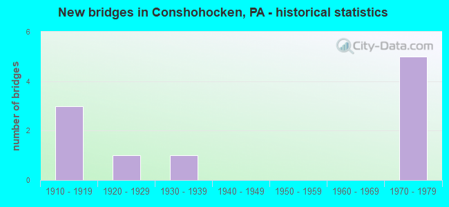
- New bridges - historical statistics
- 31910-1919
- 11920-1929
- 11930-1939
- 51970-1979
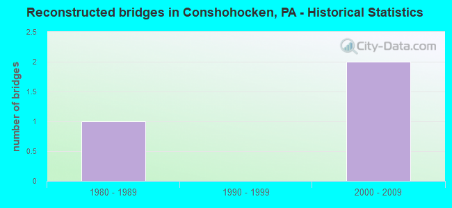
- Reconstructed bridges - Historical Statistics
- 11980-1989
- 01990-1999
- 22000-2009
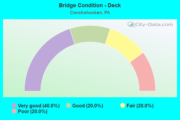
- Bridge Condition - Deck
- 40.0%Very good
- 20.0%Good
- 20.0%Fair
- 20.0%Poor
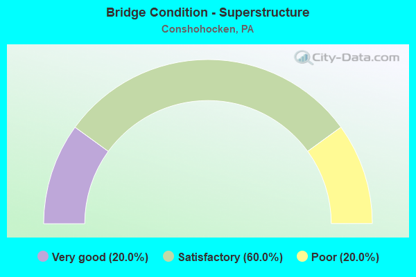
- Bridge Condition - Superstructure
- 20.0%Very good
- 60.0%Satisfactory
- 20.0%Poor
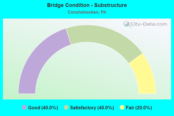
- Bridge Condition - Substructure
- 40.0%Good
- 40.0%Satisfactory
- 20.0%Fair
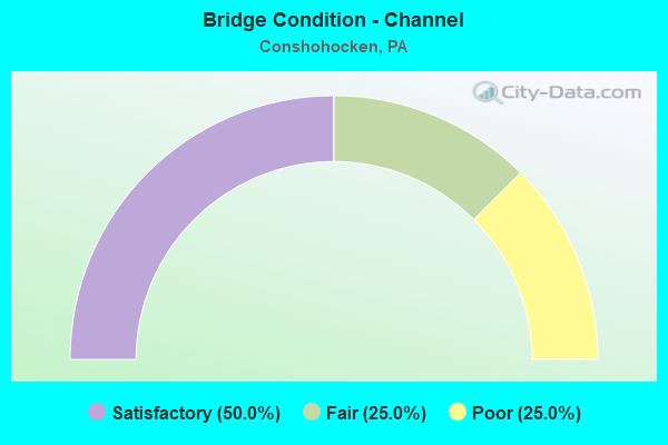
- Bridge Condition - Channel
- 50.0%Satisfactory
- 25.0%Fair
- 25.0%Poor
Find on map >> Show street view
Structure Number: 27477, Location: PLYMOUTH TOWNSHIP 35E01 (Lat: 40.083328, Lng: -75.311417), Route carried "on" structure: Interstate 476, Year Built: 1974, Year Reconstructed: 2011, Status: Open, Structure Length: 12.92m (42.39ft), Average Daily Traffic: 63,819 (year 2022), Truck Traffic: 9%, Average Future Daily Traffic: 93,194 (year 2032), Design Load: HS 20, Features Intersected: PLYMOUTH CREEK;ACCESS RD, Facility Carried by Structure: MID-COUNTY EXWY.SB
Minimum Vertical Clearance: 30+ m (98+ ft), Kilometerpoint: 4.723, Lanes on structure: 3, Lanes under structure: 2, Base Highway Network: Yes, Owner: State Highway Agency, Approaching Roadway Width: 15.8m (51.8ft), Skew: 14 degrees, Material/Design: Steel continuous, Design/Construction: Stringer/Multi-beam, Number Of Spans In Main Unit: 3, Number Of Approach Spans: 1, Length of Maximum Span: 44.5m (146.0ft), Curb or Sidewalk Widths: Left: 0.2m (0.7ft), Right: 0.2m (0.7ft), Curb-To-Curb Width: 15.6m (51.2ft), Out-to-Out Width: 16.8m (55.1ft)
Condition: Deck: Very good, Superstructure: Satisfactory, Substructure: Good, Channel: Fair, Operating Rating: 63.5 metric tons, Method Used To Determine Operating Rating: Load Factor (LF), Inventory Rating: 38.1 metric tons, Method Used To Determine Inventory Rating: Load Factor (LF), Structural Evaluation: Equal to present minimum criteria, Deck Geometry: Somewhat better than minimum adequacy, Underclear: Superior to present desirable criteria, Waterway Adequacy: Superior to present desirable criteria, Approach Roadway Alignment: Better than present minimum criteria, Length Of Structure Improvement: 13.90m (45.60ft), Designated Inspection Frequency: Every 24 months, Inspection Date: October 2019, Bridge Improvement Cost: $148,000, Roadway Improvement Cost: $435,000, Total Project Cost: $1,995,000, Deck Structure Type: Concrete Cast-file-Place, Wearing Surface/Protective System: Wearing Surface: Latex Concrete, Deck Protection: Galvanized Reinforcing
Find on map >> Show street view
Structure Number: 27479, Location: PLYMOUTH TOWNSHIP 3368A07 (Lat: 40.086139, Lng: -75.309686), Route carried "on" structure: Interstate 476, Year Built: 1974, Status: Open, Structure Length: 4.15m (13.62ft), Average Daily Traffic: 66,271 (year 2022), Truck Traffic: 8%, Average Future Daily Traffic: 92,978 (year 2032), Design Load: HS 20+Mod, Features Intersected: BROOK ROAD, Facility Carried by Structure: MID-COUNTY EXWY.NB
Minimum Vertical Clearance: 30+ m (98+ ft), Kilometerpoint: 5.412, Lanes on structure: 3, Lanes under structure: 2, Base Highway Network: Yes, Owner: State Highway Agency, Approaching Roadway Width: 15.8m (51.8ft), Skew: 13 degrees, Material/Design: Prestressed concrete, Design/Construction: Box Beam or Girders - Single/Spread, Number Of Spans In Main Unit: 3, Length of Maximum Span: 19.8m (65.0ft), Curb-To-Curb Width: 15.8m (51.8ft), Out-to-Out Width: 17.1m (56.1ft)
Condition: Deck: Good, Superstructure: Satisfactory, Substructure: Satisfactory, Operating Rating: 61.7 metric tons, Method Used To Determine Operating Rating: Load Factor (LF), Inventory Rating: 29.0 metric tons, Method Used To Determine Inventory Rating: Load Factor (LF), Structural Evaluation: Equal to present minimum criteria, Deck Geometry: Somewhat better than minimum adequacy, Underclear: Somewhat better than minimum adequacy, Approach Roadway Alignment: Equal to present desirable criteria, Length Of Structure Improvement: 5.00m (16.40ft), Designated Inspection Frequency: Every 24 months, Inspection Date: September 2021, Deck Structure Type: Concrete Cast-file-Place, Wearing Surface/Protective System: Wearing Surface: Latex Concrete, Deck Protection: Galvanized Reinforcing
Find on map >> Show street view
Structure Number: 27705, Location: .5 MI. EAST I-476 3367K08 (Lat: 40.075978, Lng: -75.312469), Route carried "on" structure: State highway , Year Built: 1924, Year Reconstructed: 2013, Status: Open, Structure Length: 4.39m (14.40ft), Average Daily Traffic: 7,487 (year 2021), Truck Traffic: 15%, Average Future Daily Traffic: 8,618 (year 2032), Design Load: HL 93, Features Intersected: ABANDON RR & PLYMOUTH CR, Facility Carried by Structure: ELM STREET
Minimum Vertical Clearance: 30+ m (98+ ft), Kilometerpoint: 0.443, Lanes on structure: 2, Owner: State Highway Agency, Approaching Roadway Width: 9.1m (29.9ft), Material/Design: Prestressed concrete continuous, Design/Construction: Box Beam or Girders - Single/Spread, Number Of Spans In Main Unit: 2, Length of Maximum Span: 21.9m (71.9ft), Curb or Sidewalk Widths: Left: 1.5m (4.9ft), Right: 1.5m (4.9ft), Curb-To-Curb Width: 9.1m (29.9ft), Out-to-Out Width: 13.1m (43.0ft)
Condition: Deck: Very good, Superstructure: Very good, Substructure: Good, Channel: Satisfactory, Operating Rating: 58.3 metric tons, Method Used To Determine Operating Rating: Assigned ratings based on Load and Resistance Factor Design (LRFD) reported by rating factor (RF) using HL93 loadings, Inventory Rating: 36.6 metric tons, Method Used To Determine Inventory Rating: Assigned ratings based on Load and Resistance Factor Design (LRFD) reported by rating factor (RF) using HL93 loadings, Structural Evaluation: Better than present minimum criteria, Deck Geometry: High priority of corrective action, Waterway Adequacy: Superior to present desirable criteria, Approach Roadway Alignment: Equal to present desirable criteria, Length Of Structure Improvement: 5.30m (17.39ft), Designated Inspection Frequency: Every 24 months, Inspection Date: November 2019, Bridge Improvement Cost: $170,000, Roadway Improvement Cost: $501,000, Total Project Cost: $2,296,000, Deck Structure Type: Concrete Cast-file-Place, Wearing Surface/Protective System: Wearing Surface: Monolithic Concrete, Deck Protection: Epoxy Coated Reinforcing
Find on map >> Show street view
Structure Number: 27721, Location: CONSHOHOCKEN 35E03 (Lat: 40.070736, Lng: -75.309250), Route carried "on" structure: State highway , Year Built: 1918, Year Reconstructed: 1987, Status: Open, Structure Length: 39.78m (130.51ft), Average Daily Traffic: 33,182 (year 2022), Truck Traffic: 4%, Average Future Daily Traffic: 42,390 (year 2032), Design Load: HS 25 or greater, Features Intersected: SCHUYKILL RIVER & NSRC, Facility Carried by Structure: FAYETTE STREET
Minimum Vertical Clearance: 30+ m (98+ ft), Kilometerpoint: 3.541, Lanes on structure: 2, Lanes under structure: 10, Base Highway Network: Yes, Owner: State Highway Agency, Approaching Roadway Width: 15.8m (51.8ft), Material/Design: Prestressed concrete continuous, Design/Construction: Stringer/Multi-beam, Number Of Spans In Main Unit: 8, Number Of Approach Spans: 4, Length of Maximum Span: 38.4m (126.0ft), Curb or Sidewalk Widths: Left: 1.8m (5.9ft), Right: 1.8m (5.9ft), Curb-To-Curb Width: 15.8m (51.8ft), Out-to-Out Width: 20.6m (67.6ft)
Condition: Deck: Fair, Superstructure: Satisfactory, Substructure: Satisfactory, Channel: Satisfactory, Operating Rating: 88.9 metric tons, Method Used To Determine Operating Rating: Load Factor (LF), Inventory Rating: 33.6 metric tons, Method Used To Determine Inventory Rating: Load Factor (LF), Structural Evaluation: Equal to present minimum criteria, Deck Geometry: Superior to present desirable criteria, Underclear: High priority of corrective action, Waterway Adequacy: Superior to present desirable criteria, Approach Roadway Alignment: Better than present minimum criteria, Length Of Structure Improvement: 40.30m (132.22ft), Designated Inspection Frequency: Every 24 months, Underwater Inspection Frequency: Every 60 months, Inspection Date: April 2021, Underwater Inspection Date: December 2017, Deck Structure Type: Concrete Cast-file-Place, Wearing Surface/Protective System: Wearing Surface: Monolithic Concrete, Deck Protection: Epoxy Coated Reinforcing
Find on map >> Show street view
Structure Number: 27771, Location: EAST CONSHOHOCKEN 35J02 (Lat: 40.076764, Lng: -75.282242), Route carried "on" structure: State highway , Year Built: 1930, Status: Open, Structure Length: 1.71m (5.61ft), Average Daily Traffic: 11,161 (year 2022), Truck Traffic: 3%, Average Future Daily Traffic: 13,710 (year 2032), Design Load: H 15, Features Intersected: SPRING MILL CREEK/3368E8, Facility Carried by Structure: HECTOR STREET
Minimum Vertical Clearance: 30+ m (98+ ft), Kilometerpoint: 1.973, Lanes on structure: 2, Owner: State Highway Agency, Approaching Roadway Width: 8.5m (27.9ft), Material/Design: Concrete, Design/Construction: Tee Beam, Number Of Spans In Main Unit: 2, Length of Maximum Span: 7.3m (24.0ft), Curb or Sidewalk Widths: Left: 1.5m (4.9ft), Right: 1.5m (4.9ft), Curb-To-Curb Width: 7.3m (24.0ft), Out-to-Out Width: 11.6m (38.1ft)
Condition: Deck: Poor, Superstructure: Poor, Substructure: Fair, Channel: Poor, Operating Rating: 59.9 metric tons, Method Used To Determine Operating Rating: Load Factor (LF), Inventory Rating: 36.3 metric tons, Method Used To Determine Inventory Rating: Load Factor (LF), Structural Evaluation: Meets minimum limits, Deck Geometry: High priority of replacement, Waterway Adequacy: Equal to present minimum criteria, Approach Roadway Alignment: Better than present minimum criteria, Length Of Structure Improvement: 2.10m (6.89ft), Designated Inspection Frequency: Every 24 months, Inspection Date: June 2021, Bridge Improvement Cost: $16,000, Roadway Improvement Cost: $46,000, Total Project Cost: $213,000, Deck Structure Type: Concrete Cast-file-Place, Wearing Surface/Protective System: Wearing Surface: Bituminous
Find on map >> Show street view
Structure Number: 27477, Location: PLYMOUTH TOWNSHIP 35E01 (Lat: 40.083328, Lng: -75.311417), Route carried "under" structure: State highway , Year Built: 1974, Structure Length: 0. m, Average Daily Traffic: 850 (year 1980), Features Intersected: PLYMOUTH CREEK;ACCESS RD, Facility Carried by Structure: MID-COUNTY EXWY.SB
Minimum Vertical Clearance: 6.83m (22.41ft), Kilometerpoint: 0.000, Lanes on structure: 3, Lanes under structure: 2, Material/Design: Steel continuous, Design/Construction: Stringer/Multi-beam, Length of Maximum Span: 44.5m (146.0ft)
Find on map >> Show street view
Structure Number: 27479, Location: PLYMOUTH TOWNSHIP 3368A07 (Lat: 40.086139, Lng: -75.309686), Route carried "under" structure: City street , Year Built: 1974, Structure Length: 0. m, Average Daily Traffic: 1,200 (year 1980), Truck Traffic: 7%, Features Intersected: BROOK ROAD, Facility Carried by Structure: MID-COUNTY EXWY.NB
Minimum Vertical Clearance: 4.42m (14.50ft), Kilometerpoint: 0.000, Lanes on structure: 3, Lanes under structure: 2, Material/Design: Prestressed concrete, Design/Construction: Box Beam or Girders - Single/Spread, Length of Maximum Span: 19.8m (65.0ft)
Find on map >> Show street view
Structure Number: 2748, Location: PLYMOUTH TOWNSHIP 29E13 (Lat: 40.086458, Lng: -75.309964), Route carried "under" structure: City street , Year Built: 1974, Structure Length: 0. m, Average Daily Traffic: 1,600 (year 1980), Truck Traffic: 7%, Features Intersected: BROOK ROAD / 3368-A7, Facility Carried by Structure: MID-COUNTY EXWY.SB
Minimum Vertical Clearance: 4.52m (14.83ft), Kilometerpoint: 0.000, Lanes on structure: 3, Lanes under structure: 2, Material/Design: Prestressed concrete, Design/Construction: Box Beam or Girders - Single/Spread, Length of Maximum Span: 20.1m (65.9ft)
Find on map >> Show street view
Structure Number: 27721, Location: CONSHOHOCKEN 35E03 (Lat: 40.070736, Lng: -75.309250), Route carried "under" structure: ServiceOther road , Year Built: 1918, Structure Length: 0. m, Average Daily Traffic: 7 (year 2005), Truck Traffic: 7%, Features Intersected: SCHUYKILL RIVER & NSRC, Facility Carried by Structure: FAYETTE STREET
Minimum Vertical Clearance: 5.56m (18.24ft), Kilometerpoint: 0.000, Lanes on structure: 2, Lanes under structure: 5, Material/Design: Prestressed concrete continuous, Design/Construction: Stringer/Multi-beam, Length of Maximum Span: 38.4m (126.0ft)
Find on map >> Show street view
Structure Number: 27721, Location: CONSHOHOCKEN 35E03 (Lat: 40.070736, Lng: -75.309250), Route carried "under" structure: ServiceOther road , Year Built: 1918, Structure Length: 0. m, Average Daily Traffic: 7 (year 2005), Truck Traffic: 7%, Features Intersected: SCHUYKILL RIVER & NSRC, Facility Carried by Structure: FAYETTE STREET
Minimum Vertical Clearance: 6.00m (19.69ft), Kilometerpoint: 0.000, Lanes on structure: 2, Lanes under structure: 2, Material/Design: Prestressed concrete continuous, Design/Construction: Stringer/Multi-beam, Length of Maximum Span: 38.4m (126.0ft)