Bridge Statistics for Coolidge, Arizona (AZ)
Condition, Traffic, Stress, Structural Evaluation, Project Costs
- National Bridge Inventory (NBI) Statistics
- 32Number of bridges
- 354ft / 108mTotal length
- $6,000Total costs
- 102,191Total average daily traffic
- 8,510Total average daily truck traffic
- 104,754Total future (year 2038) average daily traffic
- National Bridge Inventory (NBI) Registered Bridges for Coolidge
- No street view available for this location
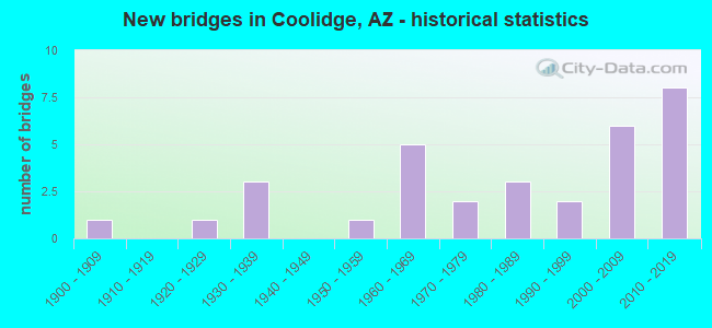
- New bridges - historical statistics
- 11900-1909
- 11920-1929
- 31930-1939
- 11950-1959
- 51960-1969
- 21970-1979
- 31980-1989
- 21990-1999
- 62000-2009
- 82010-2019

- Reconstructed bridges - Historical Statistics
- 21950-1959
- 11960-1969
- 01970-1979
- 21980-1989
- 21990-1999


- Bridge Condition - Deck
- 5.6%Very good
- 50.0%Good
- 33.3%Satisfactory
- 11.1%Fair

- Bridge Condition - Superstructure
- 22.2%Very good
- 50.0%Good
- 11.1%Satisfactory
- 11.1%Fair
- 5.6%Poor

- Bridge Condition - Substructure
- 27.8%Very good
- 38.9%Good
- 27.8%Satisfactory
- 5.6%Poor

- Bridge Condition - Channel
- 54.8%Very good
- 32.3%Good
- 12.9%Satisfactory

- Bridge Condition - Culverts
- 50.0%Very good
- 42.9%Good
- 7.1%Satisfactory
Find on map >> Show street view
Structure Number: H149, Location: 2.3 KM N OF AZ 87/287 JCT (Lat: 33.017472, Lng: -111.524444), Route carried "on" structure: Federal lands road 187, Year Built: 1960, Year Reconstructed: 1996, Status: Open, Structure Length: 5.56m (18.24ft), Average Daily Traffic: 600 (year 2021), Truck Traffic: 10%, Average Future Daily Traffic: 750 (year 2041), Design Load: HS 20, Features Intersected: GILA RIVER
Minimum Vertical Clearance: 30+ m (98+ ft), Kilometerpoint: 1.609, Lanes on structure: 2, Owner: Bureau of Indian Affairs, Approaching Roadway Width: 8.5m (27.9ft), Material/Design: Concrete continuous, Design/Construction: Slab, Number Of Spans In Main Unit: 6, Length of Maximum Span: 9.8m (32.2ft), Curb or Sidewalk Widths: Left: 0.6m (2.0ft), Right: 0.6m (2.0ft), Curb-To-Curb Width: 8.0m (26.2ft), Out-to-Out Width: 9.2m (30.2ft)
Condition: Deck: Satisfactory, Superstructure: Good, Substructure: Satisfactory, Channel: Satisfactory, Operating Rating: 44.5 metric tons, Method Used To Determine Operating Rating: Allowable Stress (AS), Inventory Rating: 32.6 metric tons, Method Used To Determine Inventory Rating: Allowable Stress (AS), Structural Evaluation: Equal to present minimum criteria, Deck Geometry: Somewhat better than minimum adequacy, Waterway Adequacy: Meets minimum limits, Approach Roadway Alignment: Equal to present desirable criteria, Designated Inspection Frequency: Every 24 months, Inspection Date: June 2021, Deck Structure Type: Concrete Cast-file-Place, Wearing Surface/Protective System: Wearing Surface: Monolithic Concrete
Find on map >> Show street view
Structure Number: H57614B0144, Location: 1.5 KM NORTH OF SACATON (Lat: 33.091694, Lng: -111.741194), Route carried "on" structure: Federal lands road 7, Year Built: 2015, Status: Open, Structure Length: 4.25m (13.94ft), Average Daily Traffic: 4,224 (year 2018), Truck Traffic: 5%, Average Future Daily Traffic: 6,252 (year 2041), Design Load: HS 20+Mod, Features Intersected: GILA RIVER
Minimum Vertical Clearance: 30+ m (98+ ft), Kilometerpoint: 3.300, Lanes on structure: 2, Owner: Bureau of Indian Affairs, Approaching Roadway Width: 7.3m (24.0ft), Skew: 1 degrees, Material/Design: Concrete, Design/Construction: Stringer/Multi-beam, Number Of Spans In Main Unit: 2, Length of Maximum Span: 21.0m (68.9ft), Curb or Sidewalk Widths: Left: 2.1m (6.9ft), Right: 0.5m (1.6ft), Curb-To-Curb Width: 13.5m (44.3ft), Out-to-Out Width: 16.3m (53.5ft)
Condition: Deck: Very good, Superstructure: Very good, Substructure: Very good, Channel: Very good, Operating Rating: 52.8 metric tons, Method Used To Determine Operating Rating: Load Factor (LF), Inventory Rating: 36.9 metric tons, Method Used To Determine Inventory Rating: Load Factor (LF), Structural Evaluation: Equal to present desirable criteria, Deck Geometry: Superior to present desirable criteria, Waterway Adequacy: Somewhat better than minimum adequacy, Approach Roadway Alignment: Equal to present desirable criteria, Designated Inspection Frequency: Every 24 months, Inspection Date: June 2021, Deck Structure Type: Concrete Precast Panels, Wearing Surface/Protective System: Wearing Surface: Monolithic Concrete
Find on map >> Show street view
Structure Number: H57614B0814, Location: 6.7 KM NORTH OF COOLIDGE (Lat: 33.038389, Lng: -111.522472), Route carried "on" structure: Federal lands road 802, Year Built: 1970, Status: Open, Structure Length: 1.37m (4.49ft), Average Daily Traffic: 75 (year 2021), Truck Traffic: 2%, Average Future Daily Traffic: 90 (year 2041), Design Load: HS 20, Features Intersected: WASH
Minimum Vertical Clearance: 30+ m (98+ ft), Kilometerpoint: 4.000, Lanes on structure: 2, Owner: Bureau of Indian Affairs, Approaching Roadway Width: 8.0m (26.2ft), Skew: 4 degrees, Material/Design: Concrete continuous, Design/Construction: Culvert, Number Of Spans In Main Unit: 3, Length of Maximum Span: 4.3m (14.1ft), Curb-To-Curb Width: 9.4m (30.8ft), Out-to-Out Width: 9.4m (30.8ft)
Condition: Channel: Good, Culverts: Satisfactory, Operating Rating: 44.4 metric tons, Method Used To Determine Operating Rating: Load Factor (LF), Inventory Rating: 32.6 metric tons, Method Used To Determine Inventory Rating: Load Factor (LF), Structural Evaluation: Equal to present minimum criteria, Deck Geometry: Better than present minimum criteria, Waterway Adequacy: Equal to present minimum criteria, Approach Roadway Alignment: Equal to present desirable criteria, Designated Inspection Frequency: Every 24 months, Inspection Date: June 2021
Find on map >> Show street view
Structure Number: H57614B0817, Location: 01.KM N OF JCT W/VEE QUIV (Lat: 33.314300, Lng: -112.182000), Route carried "on" structure: Federal lands road , Year Built: 2017, Status: Open, Structure Length: 0.64m (2.10ft), Average Daily Traffic: 1,000 (year 2021), Truck Traffic: 5%, Average Future Daily Traffic: 1,100 (year 2041), Design Load: HS 20, Features Intersected: DRAW, Facility Carried by Structure: S. KAMATKE LANE
Minimum Vertical Clearance: 30+ m (98+ ft), Kilometerpoint: 0.000, Lanes on structure: 4, Owner: Bureau of Indian Affairs, Approaching Roadway Width: 17.0m (55.8ft), Skew: 1 degrees, Material/Design: Steel, Design/Construction: Culvert, Number Of Spans In Main Unit: 4, Length of Maximum Span: 1.2m (3.9ft), Curb-To-Curb Width: 17.0m (55.8ft), Out-to-Out Width: 17.0m (55.8ft)
Condition: Channel: Very good, Culverts: Good, Operating Rating: 36.2 metric tons, Method Used To Determine Operating Rating: Field evaluation and documented engineering judgment, Inventory Rating: 32.6 metric tons, Method Used To Determine Inventory Rating: Field evaluation and documented engineering judgment, Structural Evaluation: Better than present minimum criteria, Deck Geometry: Somewhat better than minimum adequacy, Waterway Adequacy: Equal to present desirable criteria, Approach Roadway Alignment: Equal to present desirable criteria, Designated Inspection Frequency: Every 24 months, Inspection Date: December 2021
Find on map >> Show street view
Structure Number: 546, Location: 03.9 mi N Jct SR 287 (Lat: 32.936100, Lng: -111.515000), Route carried "on" structure: State highway 87, Year Built: 1931, Year Reconstructed: 1959, Status: Open, Structure Length: 6.10m (20.01ft), Average Daily Traffic: 7,543 (year 2020), Truck Traffic: 14%, Average Future Daily Traffic: 7,553 (year 2040), Design Load: HS 20, Features Intersected: Mc Clellan Wash
Minimum Vertical Clearance: 30+ m (98+ ft), Kilometerpoint: 208.893, Lanes on structure: 2, Owner: State Highway Agency, Approaching Roadway Width: 12.2m (40.0ft), Material/Design: Concrete, Design/Construction: Slab, Number Of Spans In Main Unit: 10, Length of Maximum Span: 6.1m (20.0ft), Curb-To-Curb Width: 9.7m (31.8ft), Out-to-Out Width: 10.7m (35.1ft)
Condition: Deck: Satisfactory, Superstructure: Satisfactory, Substructure: Satisfactory, Channel: Good, Operating Rating: 49.9 metric tons, Method Used To Determine Operating Rating: Load Factor (LF), Inventory Rating: 29.9 metric tons, Method Used To Determine Inventory Rating: Load Factor (LF), Structural Evaluation: Equal to present minimum criteria, Deck Geometry: Meets minimum limits, Waterway Adequacy: Equal to present desirable criteria, Approach Roadway Alignment: Equal to present desirable criteria, Length Of Structure Improvement: 7.01m (23.00ft), Designated Inspection Frequency: Every 24 months, Inspection Date: October 2021, Total Project Cost: $1,000 ( Estimate for 2021), Deck Structure Type: Concrete Cast-file-Place, Wearing Surface/Protective System: Wearing Surface: Bituminous
Find on map >> Show street view
Structure Number: 579, Location: 3.4 mi W Jct SR 287 (Lat: 33.002500, Lng: -111.577100), Route carried "on" structure: State highway 87, Year Built: 1920, Year Reconstructed: 1960, Status: Open, Structure Length: 1.89m (6.20ft), Average Daily Traffic: 11,829 (year 2019), Truck Traffic: 6%, Average Future Daily Traffic: 11,839 (year 2039), Design Load: HS 20, Features Intersected: Pima Lateral Canal
Minimum Vertical Clearance: 30+ m (98+ ft), Kilometerpoint: 221.607, Lanes on structure: 2, Owner: State Highway Agency, Approaching Roadway Width: 12.8m (42.0ft), Skew: 5 degrees, Material/Design: Concrete continuous, Design/Construction: Slab, Number Of Spans In Main Unit: 3, Length of Maximum Span: 6.1m (20.0ft), Curb-To-Curb Width: 12.7m (41.7ft), Out-to-Out Width: 13.6m (44.6ft)
Condition: Deck: Fair, Superstructure: Fair, Substructure: Satisfactory, Channel: Very good, Operating Rating: 43.5 metric tons, Method Used To Determine Operating Rating: Load Factor (LF), Inventory Rating: 26.3 metric tons, Method Used To Determine Inventory Rating: Load Factor (LF), Structural Evaluation: Somewhat better than minimum adequacy, Deck Geometry: Somewhat better than minimum adequacy, Waterway Adequacy: Better than present minimum criteria, Approach Roadway Alignment: Equal to present desirable criteria, Length Of Structure Improvement: 2.65m (8.69ft), Designated Inspection Frequency: Every 24 months, Inspection Date: January 2022, Total Project Cost: $1,000 ( Estimate for 2022), Deck Structure Type: Concrete Cast-file-Place, Wearing Surface/Protective System: Wearing Surface: Monolithic Concrete
Find on map >> Show street view
Structure Number: 61, Location: 4.7 mi W Jct SR 287 (Lat: 33.002600, Lng: -111.599800), Route carried "on" structure: State highway 87, Year Built: 1960, Status: Open, Structure Length: 3.63m (11.91ft), Average Daily Traffic: 10,940 (year 2020), Truck Traffic: 6%, Average Future Daily Traffic: 10,950 (year 2040), Design Load: HS 20, Features Intersected: McClellan Wash
Minimum Vertical Clearance: 30+ m (98+ ft), Kilometerpoint: 223.715, Lanes on structure: 2, Owner: State Highway Agency, Approaching Roadway Width: 12.2m (40.0ft), Skew: 3 degrees, Material/Design: Concrete continuous, Design/Construction: Slab, Number Of Spans In Main Unit: 5, Length of Maximum Span: 7.6m (24.9ft), Curb-To-Curb Width: 12.7m (41.7ft), Out-to-Out Width: 13.6m (44.6ft)
Condition: Deck: Fair, Superstructure: Fair, Substructure: Good, Channel: Good, Operating Rating: 37.2 metric tons, Method Used To Determine Operating Rating: Load Factor (LF), Inventory Rating: 21.8 metric tons, Method Used To Determine Inventory Rating: Load Factor (LF), Structural Evaluation: Somewhat better than minimum adequacy, Deck Geometry: Somewhat better than minimum adequacy, Waterway Adequacy: Equal to present desirable criteria, Approach Roadway Alignment: Equal to present desirable criteria, Length Of Structure Improvement: 4.45m (14.60ft), Designated Inspection Frequency: Every 24 months, Inspection Date: October 2021, Total Project Cost: $1,000 ( Estimate for 2021), Deck Structure Type: Concrete Cast-file-Place, Wearing Surface/Protective System: Wearing Surface: Monolithic Concrete
Find on map >> Show street view
Structure Number: 2453, Location: 0.1 mi E Jct SR 87 (Lat: 33.002597, Lng: -111.519767), Route carried "on" structure: State highway 287, Year Built: 1999, Status: Open, Structure Length: 5.24m (17.19ft), Average Daily Traffic: 10,952 (year 2016), Truck Traffic: 11%, Average Future Daily Traffic: 10,962 (year 2038), Design Load: HS 20, Features Intersected: UPRR
Minimum Vertical Clearance: 30+ m (98+ ft), Kilometerpoint: 217.036, Lanes on structure: 2, Owner: State Highway Agency, Approaching Roadway Width: 11.9m (39.0ft), Material/Design: Prestressed concrete continuous, Design/Construction: Stringer/Multi-beam, Number Of Spans In Main Unit: 3, Length of Maximum Span: 21.0m (68.9ft), Curb-To-Curb Width: 13.2m (43.3ft), Out-to-Out Width: 14.2m (46.6ft)
Condition: Deck: Good, Superstructure: Good, Substructure: Good, Operating Rating: 89.8 metric tons, Method Used To Determine Operating Rating: Load Factor (LF), Inventory Rating: 36.3 metric tons, Method Used To Determine Inventory Rating: Load Factor (LF), Structural Evaluation: Better than present minimum criteria, Deck Geometry: Somewhat better than minimum adequacy, Underclear: Superior to present desirable criteria, Approach Roadway Alignment: Equal to present desirable criteria, Designated Inspection Frequency: Every 24 months, Inspection Date: Febuary 2022, Deck Structure Type: Concrete Cast-file-Place, Wearing Surface/Protective System: Wearing Surface: Monolithic Concrete
Find on map >> Show street view
Structure Number: 2824, Location: 18 mi N Jct I-10 (Lat: 32.991400, Lng: -111.523900), Route carried "on" structure: State highway 87, Year Built: 2005, Status: Open, Structure Length: 2.23m (7.32ft), Design Load: Pedestrian, Features Intersected: Pima Lateral Canal, Facility Carried by Structure: Coolidge Ped Path
Minimum Vertical Clearance: 2.53m (8.30ft), Kilometerpoint: 215.652, Owner: State Highway Agency, Material/Design: Steel, Design/Construction: Truss - Thru, Number Of Spans In Main Unit: 1, Length of Maximum Span: 21.3m (69.9ft), Curb-To-Curb Width: 3.0m (9.8ft), Out-to-Out Width: 3.4m (11.2ft)
Condition: Deck: Good, Superstructure: Very good, Substructure: Very good, Channel: Very good, Structural Evaluation: High priority of corrective action, Waterway Adequacy: Equal to present desirable criteria, Designated Inspection Frequency: Every 24 months, Inspection Date: October 2021, Deck Structure Type: Concrete Cast-file-Place, Wearing Surface/Protective System: Wearing Surface: Monolithic Concrete
Find on map >> Show street view
Structure Number: 4628, Location: 0.8 mi S Jct SR 287 (Lat: 32.867700, Lng: -111.515200), Route carried "on" structure: State highway 87, Year Built: 1931, Year Reconstructed: 1961, Status: Open, Structure Length: 0.88m (2.89ft), Average Daily Traffic: 5,099 (year 2020), Truck Traffic: 12%, Average Future Daily Traffic: 5,109 (year 2040), Design Load: HS 20, Features Intersected: Casa Grande Canal
Minimum Vertical Clearance: 30+ m (98+ ft), Kilometerpoint: 201.380, Lanes on structure: 2, Owner: State Highway Agency, Approaching Roadway Width: 12.5m (41.0ft), Skew: 4 degrees, Material/Design: Concrete continuous, Design/Construction: Culvert, Number Of Spans In Main Unit: 2, Length of Maximum Span: 3.0m (9.8ft)
Condition: Channel: Very good, Culverts: Good, Operating Rating: 64.4 metric tons, Method Used To Determine Operating Rating: Load Factor (LF), Inventory Rating: 38.1 metric tons, Method Used To Determine Inventory Rating: Load Factor (LF), Structural Evaluation: Better than present minimum criteria, Waterway Adequacy: Equal to present minimum criteria, Approach Roadway Alignment: Equal to present desirable criteria, Designated Inspection Frequency: Every 48 months, Inspection Date: October 2021
Find on map >> Show street view
Structure Number: 4629, Location: 3.6 mi N Jct SR 287 (Lat: 32.932300, Lng: -111.515000), Route carried "on" structure: State highway 87, Year Built: 1959, Status: Open, Structure Length: 0.98m (3.22ft), Average Daily Traffic: 7,543 (year 2020), Truck Traffic: 14%, Average Future Daily Traffic: 7,553 (year 2040), Design Load: HS 20, Features Intersected: Wash
Minimum Vertical Clearance: 30+ m (98+ ft), Kilometerpoint: 208.540, Lanes on structure: 2, Owner: State Highway Agency, Approaching Roadway Width: 12.2m (40.0ft), Material/Design: Concrete continuous, Design/Construction: Culvert, Number Of Spans In Main Unit: 3, Length of Maximum Span: 3.0m (9.8ft), Curb or Sidewalk Widths: Left: 0.2m (0.7ft), Right: 0.2m (0.7ft), Curb-To-Curb Width: 13.7m (44.9ft), Out-to-Out Width: 14.5m (47.6ft)
Condition: Channel: Good, Culverts: Good, Operating Rating: 53.5 metric tons, Method Used To Determine Operating Rating: Load Factor (LF), Inventory Rating: 31.8 metric tons, Method Used To Determine Inventory Rating: Load Factor (LF), Structural Evaluation: Better than present minimum criteria, Deck Geometry: Superior to present desirable criteria, Waterway Adequacy: Equal to present desirable criteria, Approach Roadway Alignment: Equal to present desirable criteria, Designated Inspection Frequency: Every 48 months, Inspection Date: October 2021, Deck Structure Type: Concrete Cast-file-Place, Wearing Surface/Protective System: Wearing Surface: Bituminous
Find on map >> Show street view
Structure Number: 5124, Location: 5.9 mi W Jct US 89 (Lat: 33.005556, Lng: -111.475000), Route carried "on" structure: State highway 287, Year Built: 1962, Status: Open, Structure Length: 0.88m (2.89ft), Average Daily Traffic: 10,952 (year 2016), Truck Traffic: 11%, Average Future Daily Traffic: 10,962 (year 2038), Design Load: HS 20, Features Intersected: Wash
Minimum Vertical Clearance: 30+ m (98+ ft), Kilometerpoint: 222.290, Lanes on structure: 2, Owner: State Highway Agency, Approaching Roadway Width: 12.2m (40.0ft), Skew: 3 degrees, Material/Design: Concrete continuous, Design/Construction: Culvert, Number Of Spans In Main Unit: 2, Length of Maximum Span: 3.7m (12.1ft)
Condition: Channel: Satisfactory, Culverts: Good, Operating Rating: 58.1 metric tons, Method Used To Determine Operating Rating: Load Factor (LF), Inventory Rating: 35.4 metric tons, Method Used To Determine Inventory Rating: Load Factor (LF), Structural Evaluation: Better than present minimum criteria, Waterway Adequacy: Better than present minimum criteria, Approach Roadway Alignment: Better than present minimum criteria, Length Of Structure Improvement: 1.62m (5.31ft), Designated Inspection Frequency: Every 48 months, Inspection Date: Febuary 2022, Total Project Cost: $1,000 ( Estimate for 2018)
Find on map >> Show street view
Structure Number: 7724, Location: 0.8 mi N Jct SR 287 (Lat: 33.015300, Lng: -111.473300), Route carried "on" structure: County highway , Year Built: 1989, Year Reconstructed: 1993, Status: Open, Structure Length: 43.31m (142.09ft), Average Daily Traffic: 7,675 (year 2021), Truck Traffic: 5%, Average Future Daily Traffic: 7,685 (year 2041), Design Load: HS 20, Features Intersected: Gila River, Facility Carried by Structure: Attaway Rd
Minimum Vertical Clearance: 30+ m (98+ ft), Kilometerpoint: 0.000, Lanes on structure: 2, Owner: County Highway Agency, Approaching Roadway Width: 8.2m (26.9ft), Material/Design: Prestressed concrete continuous, Design/Construction: Stringer/Multi-beam, Number Of Spans In Main Unit: 10, Number Of Approach Spans: 1, Length of Maximum Span: 39.6m (129.9ft), Curb-To-Curb Width: 9.7m (31.8ft), Out-to-Out Width: 10.7m (35.1ft)
Condition: Deck: Good, Superstructure: Good, Substructure: Very good, Channel: Good, Operating Rating: 84.4 metric tons, Method Used To Determine Operating Rating: Load Factor (LF), Inventory Rating: 32.7 metric tons, Method Used To Determine Inventory Rating: Load Factor (LF), Structural Evaluation: Better than present minimum criteria, Deck Geometry: Meets minimum limits, Waterway Adequacy: Equal to present desirable criteria, Approach Roadway Alignment: Equal to present desirable criteria, Designated Inspection Frequency: Every 24 months, Inspection Date: October 2021, Deck Structure Type: Concrete Cast-file-Place, Wearing Surface/Protective System: Wearing Surface: Monolithic Concrete
Find on map >> Show street view
Structure Number: 7913, Location: 32 ft N Jct Coolidge Ave (Lat: 32.973433, Lng: -111.541258), Route carried "on" structure: City street , Year Built: 1993, Year Reconstructed: 2004, Status: Open, Structure Length: 0.64m (2.10ft), Average Daily Traffic: 3,000 (year 2019), Truck Traffic: 10%, Average Future Daily Traffic: 3,010 (year 2039), Design Load: HS 20, Features Intersected: Drainage Ditch, Facility Carried by Structure: Kenworthy Road
Minimum Vertical Clearance: 30+ m (98+ ft), Kilometerpoint: 0.000, Lanes on structure: 4, Owner: City or Municipal Highway Agency, Approaching Roadway Width: 19.5m (64.0ft), Material/Design: Concrete continuous, Design/Construction: Culvert, Number Of Spans In Main Unit: 2, Length of Maximum Span: 3.0m (9.8ft)
Condition: Channel: Good, Culverts: Very good, Operating Rating: 52.6 metric tons, Method Used To Determine Operating Rating: Load Factor (LF), Inventory Rating: 31.8 metric tons, Method Used To Determine Inventory Rating: Load Factor (LF), Structural Evaluation: Better than present minimum criteria, Waterway Adequacy: Equal to present desirable criteria, Approach Roadway Alignment: Equal to present desirable criteria, Designated Inspection Frequency: Every 48 months, Inspection Date: October 2019, Deck Structure Type: Concrete Cast-file-Place, Wearing Surface/Protective System: Wearing Surface: Bituminous
Find on map >> Show street view
Structure Number: 8208, Location: 100 ft S Jct SR 87 (Lat: 33.001950, Lng: -111.575956), Route carried "on" structure: City street , Year Built: 1936, Year Reconstructed: 1980, Status: Open, Structure Length: 1.28m (4.20ft), Average Daily Traffic: 45 (year 2020), Truck Traffic: 1%, Average Future Daily Traffic: 55 (year 2040), Design Load: HS 20, Features Intersected: Pima Lateral Canal, Facility Carried by Structure: MacRae Rd
Minimum Vertical Clearance: 30+ m (98+ ft), Kilometerpoint: 0.000, Lanes on structure: 2, Owner: City or Municipal Highway Agency, Approaching Roadway Width: 7.9m (25.9ft), Material/Design: Prestressed concrete, Design/Construction: Box Beam or Girders - Multiple, Number Of Spans In Main Unit: 1, Length of Maximum Span: 12.2m (40.0ft), Curb-To-Curb Width: 7.9m (25.9ft), Out-to-Out Width: 8.5m (27.9ft)
Condition: Deck: Satisfactory, Superstructure: Good, Substructure: Satisfactory, Channel: Very good, Operating Rating: 69.9 metric tons, Method Used To Determine Operating Rating: Load Factor (LF), Inventory Rating: 32.7 metric tons, Method Used To Determine Inventory Rating: Load Factor (LF), Structural Evaluation: Equal to present minimum criteria, Deck Geometry: Equal to present minimum criteria, Waterway Adequacy: Equal to present minimum criteria, Approach Roadway Alignment: Equal to present desirable criteria, Designated Inspection Frequency: Every 24 months, Inspection Date: October 2021, Deck Structure Type: Concrete Cast-file-Place, Wearing Surface/Protective System: Wearing Surface: Monolithic Concrete
Find on map >> Show street view
Structure Number: 8436, Location: 0.1 mi E Jct SR 87 (Lat: 32.850500, Lng: -111.513900), Route carried "on" structure: City street , Year Built: 1900, Status: Open, Structure Length: 0.98m (3.22ft), Average Daily Traffic: 450 (year 2020), Truck Traffic: 5%, Average Future Daily Traffic: 460 (year 2040), Features Intersected: Casa Grande Canal Ext, Facility Carried by Structure: Selma Highway
Minimum Vertical Clearance: 30+ m (98+ ft), Kilometerpoint: 0.000, Lanes on structure: 2, Owner: City or Municipal Highway Agency, Approaching Roadway Width: 5.5m (18.0ft), Material/Design: Wood or Timber, Design/Construction: Stringer/Multi-beam, Number Of Spans In Main Unit: 2, Length of Maximum Span: 4.6m (15.1ft), Curb or Sidewalk Widths: Left: 0.2m (0.7ft), Right: 0.2m (0.7ft), Curb-To-Curb Width: 6.4m (21.0ft), Out-to-Out Width: 6.9m (22.6ft)
Condition: Deck: Satisfactory, Superstructure: Poor, Substructure: Poor, Channel: Good, Operating Rating: 9.1 metric tons, Method Used To Determine Operating Rating: Allowable Stress (AS), Inventory Rating: 5.4 metric tons, Method Used To Determine Inventory Rating: Allowable Stress (AS), Structural Evaluation: High priority of replacement, Deck Geometry: High priority of corrective action, Waterway Adequacy: Better than present minimum criteria, Approach Roadway Alignment: Equal to present desirable criteria, Bridge Posting: Required (Relationship of Operating Rating to Maximum Legal Load: > 39.9% below), Length Of Structure Improvement: 1.74m (5.71ft), Designated Inspection Frequency: Every 24 months, Inspection Date: January 2022, Total Project Cost: $1,000 ( Estimate for 2022), Deck Structure Type: Wood or Timber, Wearing Surface/Protective System: Wearing Surface: Bituminous
Find on map >> Show street view
Structure Number: 8437, Location: 0.8 mi S Jct SR 287 (Lat: 32.868700, Lng: -111.532500), Route carried "on" structure: County highway , Year Built: 1975, Status: Open, Structure Length: 1.04m (3.41ft), Average Daily Traffic: 450 (year 2020), Truck Traffic: 1%, Average Future Daily Traffic: 460 (year 2040), Design Load: HS 20, Features Intersected: Casa Grande Canal, Facility Carried by Structure: La Palma Road
Minimum Vertical Clearance: 7.62m (25.00ft), Kilometerpoint: 0.000, Lanes on structure: 2, Owner: County Highway Agency, Approaching Roadway Width: 7.9m (25.9ft), Material/Design: Prestressed concrete, Design/Construction: Box Beam or Girders - Multiple, Number Of Spans In Main Unit: 1, Length of Maximum Span: 9.8m (32.2ft), Curb-To-Curb Width: 10.5m (34.4ft), Out-to-Out Width: 11.1m (36.4ft)
Condition: Deck: Satisfactory, Superstructure: Satisfactory, Substructure: Satisfactory, Channel: Good, Operating Rating: 36.3 metric tons, Method Used To Determine Operating Rating: Field evaluation and documented engineering judgment, Inventory Rating: 21.8 metric tons, Method Used To Determine Inventory Rating: Field evaluation and documented engineering judgment, Structural Evaluation: Equal to present minimum criteria, Deck Geometry: Equal to present minimum criteria, Waterway Adequacy: Better than present minimum criteria, Approach Roadway Alignment: Equal to present desirable criteria, Designated Inspection Frequency: Every 24 months, Inspection Date: January 2022, Deck Structure Type: Concrete Precast Panels, Wearing Surface/Protective System: Wearing Surface: Bituminous
Find on map >> Show street view
Structure Number: 884, Location: 0.5 mi S Cactus Forest Rd (Lat: 32.961500, Lng: -111.421700), Route carried "on" structure: County highway , Year Built: 1985, Status: Open, Structure Length: 4.88m (16.01ft), Average Daily Traffic: 200 (year 2020), Truck Traffic: 5%, Average Future Daily Traffic: 210 (year 2040), Design Load: HS 20, Features Intersected: CAP Canal, Facility Carried by Structure: Airport Road
Minimum Vertical Clearance: 30+ m (98+ ft), Kilometerpoint: 0.000, Lanes on structure: 2, Owner: County Highway Agency, Approaching Roadway Width: 7.3m (24.0ft), Skew: 5 degrees, Material/Design: Prestressed concrete continuous, Design/Construction: Stringer/Multi-beam, Number Of Spans In Main Unit: 2, Length of Maximum Span: 23.2m (76.1ft), Curb or Sidewalk Widths: Left: 0.0m, Right: 1.8m (5.9ft), Curb-To-Curb Width: 10.3m (33.8ft), Out-to-Out Width: 10.6m (34.8ft)
Condition: Deck: Good, Superstructure: Very good, Substructure: Good, Channel: Very good, Operating Rating: 75.3 metric tons, Method Used To Determine Operating Rating: Load Factor (LF), Inventory Rating: 41.7 metric tons, Method Used To Determine Inventory Rating: Load Factor (LF), Structural Evaluation: Better than present minimum criteria, Deck Geometry: Better than present minimum criteria, Waterway Adequacy: Equal to present desirable criteria, Approach Roadway Alignment: Equal to present desirable criteria, Designated Inspection Frequency: Every 24 months, Underwater Inspection Frequency: Every 60 months, Inspection Date: Febuary 2020, Underwater Inspection Date: November 2020, Deck Structure Type: Concrete Cast-file-Place, Wearing Surface/Protective System: Wearing Surface: Monolithic Concrete
Find on map >> Show street view
Structure Number: 9061, Location: 5.8 mi E Jct SR 87 (Lat: 32.973533, Lng: -111.424469), Route carried "on" structure: City street , Year Built: 1961, Status: Open, Structure Length: 2.90m (9.51ft), Average Daily Traffic: 1,598 (year 2020), Truck Traffic: 5%, Average Future Daily Traffic: 1,608 (year 2040), Design Load: HS 20, Features Intersected: Florence-Casa Grande Cnl, Facility Carried by Structure: Kenilworth Road
Minimum Vertical Clearance: 5.49m (18.01ft), Kilometerpoint: 0.000, Lanes on structure: 2, Owner: City or Municipal Highway Agency, Approaching Roadway Width: 8.5m (27.9ft), Skew: 3 degrees, Material/Design: Concrete continuous, Design/Construction: Slab, Number Of Spans In Main Unit: 3, Length of Maximum Span: 10.7m (35.1ft), Curb or Sidewalk Widths: Left: 0.3m (1.0ft), Right: 0.3m (1.0ft), Curb-To-Curb Width: 8.5m (27.9ft), Out-to-Out Width: 9.3m (30.5ft)
Condition: Deck: Good, Superstructure: Good, Substructure: Good, Channel: Good, Operating Rating: 36.3 metric tons, Method Used To Determine Operating Rating: Load Factor (LF), Inventory Rating: 21.8 metric tons, Method Used To Determine Inventory Rating: Load Factor (LF), Structural Evaluation: Somewhat better than minimum adequacy, Deck Geometry: Somewhat better than minimum adequacy, Waterway Adequacy: Equal to present desirable criteria, Approach Roadway Alignment: Equal to present desirable criteria, Length Of Structure Improvement: 3.72m (12.20ft), Designated Inspection Frequency: Every 24 months, Inspection Date: October 2021, Total Project Cost: $1,000 ( Estimate for 2021), Deck Structure Type: Concrete Cast-file-Place, Wearing Surface/Protective System: Wearing Surface: Monolithic Concrete
Find on map >> Show street view
Structure Number: 9062, Location: 5.0 mi E Jct SR 87 (Lat: 32.973800, Lng: -111.438200), Route carried "on" structure: City street , Year Built: 1961, Status: Open, Structure Length: 0.64m (2.10ft), Average Daily Traffic: 1,000 (year 2019), Truck Traffic: 5%, Average Future Daily Traffic: 1,010 (year 2039), Design Load: HS 20, Features Intersected: Bogart Wash, Facility Carried by Structure: Kenilworth Road
Minimum Vertical Clearance: 30+ m (98+ ft), Kilometerpoint: 0.000, Lanes on structure: 2, Owner: City or Municipal Highway Agency, Approaching Roadway Width: 7.9m (25.9ft), Material/Design: Concrete continuous, Design/Construction: Culvert, Number Of Spans In Main Unit: 2, Length of Maximum Span: 3.0m (9.8ft), Curb or Sidewalk Widths: Left: 0.3m (1.0ft), Right: 0.3m (1.0ft), Curb-To-Curb Width: 7.9m (25.9ft), Out-to-Out Width: 11.0m (36.1ft)
Condition: Channel: Satisfactory, Culverts: Good, Operating Rating: 52.6 metric tons, Method Used To Determine Operating Rating: Load Factor (LF), Inventory Rating: 31.8 metric tons, Method Used To Determine Inventory Rating: Load Factor (LF), Structural Evaluation: Better than present minimum criteria, Deck Geometry: Somewhat better than minimum adequacy, Waterway Adequacy: Meets minimum limits, Approach Roadway Alignment: Equal to present desirable criteria, Designated Inspection Frequency: Every 48 months, Inspection Date: October 2019, Deck Structure Type: Concrete Cast-file-Place, Wearing Surface/Protective System: Wearing Surface: Bituminous
Find on map >> Show street view
Structure Number: 9888, Location: 5.0 mi W Jct SR 79 (Lat: 32.969900, Lng: -111.415500), Route carried "on" structure: County highway , Year Built: 1985, Status: Open, Structure Length: 2.65m (8.69ft), Average Daily Traffic: 969 (year 2019), Truck Traffic: 5%, Average Future Daily Traffic: 979 (year 2039), Design Load: HS 20, Features Intersected: CAP Canal, Facility Carried by Structure: Cactus Forest Rd
Minimum Vertical Clearance: 30+ m (98+ ft), Kilometerpoint: 0.000, Lanes on structure: 2, Owner: County Highway Agency, Approaching Roadway Width: 7.9m (25.9ft), Material/Design: Prestressed concrete, Design/Construction: Stringer/Multi-beam, Number Of Spans In Main Unit: 1, Length of Maximum Span: 25.9m (85.0ft), Curb-To-Curb Width: 9.8m (32.2ft), Out-to-Out Width: 10.6m (34.8ft)
Condition: Deck: Good, Superstructure: Good, Substructure: Good, Channel: Very good, Operating Rating: 54.4 metric tons, Method Used To Determine Operating Rating: Field evaluation and documented engineering judgment, Inventory Rating: 32.7 metric tons, Method Used To Determine Inventory Rating: Field evaluation and documented engineering judgment, Structural Evaluation: Better than present minimum criteria, Deck Geometry: Equal to present minimum criteria, Waterway Adequacy: Equal to present desirable criteria, Approach Roadway Alignment: Equal to present desirable criteria, Designated Inspection Frequency: Every 24 months, Inspection Date: Febuary 2020, Deck Structure Type: Concrete Cast-file-Place, Wearing Surface/Protective System: Wearing Surface: Monolithic Concrete
Find on map >> Show street view
Structure Number: 10119, Location: 0.5 mi S Jct Coolidge Rd (Lat: 32.966300, Lng: -111.438400), Route carried "on" structure: City street , Year Built: 2002, Status: Open, Structure Length: 1.43m (4.69ft), Average Daily Traffic: 50 (year 2022), Truck Traffic: 5%, Average Future Daily Traffic: 60 (year 2042), Design Load: HS 20, Features Intersected: Pima Lateral Canal, Facility Carried by Structure: Valley Farms Road
Minimum Vertical Clearance: 7.62m (25.00ft), Kilometerpoint: 0.000, Lanes on structure: 2, Owner: City or Municipal Highway Agency, Approaching Roadway Width: 10.4m (34.1ft), Material/Design: Prestressed concrete, Design/Construction: Box Beam or Girders - Multiple, Number Of Spans In Main Unit: 1, Length of Maximum Span: 13.4m (44.0ft), Curb-To-Curb Width: 10.4m (34.1ft), Out-to-Out Width: 11.0m (36.1ft)
Condition: Deck: Good, Superstructure: Good, Substructure: Good, Channel: Good, Operating Rating: 60.8 metric tons, Method Used To Determine Operating Rating: Load Factor (LF), Inventory Rating: 36.3 metric tons, Method Used To Determine Inventory Rating: Load Factor (LF), Structural Evaluation: Better than present minimum criteria, Deck Geometry: Superior to present desirable criteria, Waterway Adequacy: Better than present minimum criteria, Approach Roadway Alignment: Equal to present desirable criteria, Designated Inspection Frequency: Every 24 months, Inspection Date: January 2022, Deck Structure Type: Concrete Cast-file-Place, Wearing Surface/Protective System: Wearing Surface: Monolithic Concrete
Find on map >> Show street view
Structure Number: 10128, Location: 1.5 mi S Jct SR 87 (Lat: 32.978197, Lng: -111.601150), Route carried "on" structure: City street , Year Built: 2001, Status: Open, Structure Length: 1.52m (4.99ft), Average Daily Traffic: 49 (year 2020), Truck Traffic: 5%, Average Future Daily Traffic: 59 (year 2040), Design Load: HS 20, Features Intersected: South Side Curry Rd Cnl, Facility Carried by Structure: Curry Road
Minimum Vertical Clearance: 30+ m (98+ ft), Kilometerpoint: 0.000, Lanes on structure: 2, Owner: City or Municipal Highway Agency, Approaching Roadway Width: 10.4m (34.1ft), Material/Design: Prestressed concrete, Design/Construction: Box Beam or Girders - Multiple, Number Of Spans In Main Unit: 1, Length of Maximum Span: 14.3m (46.9ft), Curb-To-Curb Width: 10.2m (33.5ft), Out-to-Out Width: 11.0m (36.1ft)
Condition: Deck: Good, Superstructure: Good, Substructure: Very good, Channel: Very good, Operating Rating: 59.0 metric tons, Method Used To Determine Operating Rating: Load Factor (LF), Inventory Rating: 35.4 metric tons, Method Used To Determine Inventory Rating: Load Factor (LF), Structural Evaluation: Better than present minimum criteria, Deck Geometry: Superior to present desirable criteria, Waterway Adequacy: Better than present minimum criteria, Approach Roadway Alignment: Equal to present desirable criteria, Designated Inspection Frequency: Every 24 months, Inspection Date: January 2022, Deck Structure Type: Concrete Cast-file-Place, Wearing Surface/Protective System: Wearing Surface: Monolithic Concrete
Find on map >> Show street view
Structure Number: 10351, Location: 0.3 mi E Jct Curry Road (Lat: 32.981742, Lng: -111.595781), Route carried "on" structure: City street , Year Built: 2004, Status: Open, Structure Length: 1.68m (5.51ft), Average Daily Traffic: 90 (year 2021), Truck Traffic: 5%, Average Future Daily Traffic: 100 (year 2041), Design Load: HS 20, Features Intersected: South Side Canal, Facility Carried by Structure: IRR Bechtel Road
Minimum Vertical Clearance: 30+ m (98+ ft), Kilometerpoint: 0.000, Lanes on structure: 2, Owner: City or Municipal Highway Agency, Approaching Roadway Width: 10.1m (33.1ft), Skew: 4 degrees, Material/Design: Prestressed concrete, Design/Construction: Box Beam or Girders - Multiple, Number Of Spans In Main Unit: 1, Length of Maximum Span: 14.9m (48.9ft), Curb-To-Curb Width: 10.1m (33.1ft), Out-to-Out Width: 11.0m (36.1ft)
Condition: Deck: Satisfactory, Superstructure: Very good, Substructure: Very good, Channel: Very good, Operating Rating: 66.2 metric tons, Method Used To Determine Operating Rating: Load Factor (LF), Inventory Rating: 37.2 metric tons, Method Used To Determine Inventory Rating: Load Factor (LF), Structural Evaluation: Equal to present desirable criteria, Deck Geometry: Superior to present desirable criteria, Waterway Adequacy: Better than present minimum criteria, Approach Roadway Alignment: Equal to present desirable criteria, Designated Inspection Frequency: Every 24 months, Inspection Date: October 2021, Deck Structure Type: Concrete Cast-file-Place, Wearing Surface/Protective System: Wearing Surface: Monolithic Concrete
Find on map >> Show street view
Structure Number: 10356, Location: 0.5 mi S of Kenilworth Rd (Lat: 32.966400, Lng: -111.473000), Route carried "on" structure: City street , Year Built: 2004, Status: Open, Structure Length: 1.43m (4.69ft), Average Daily Traffic: 638 (year 2020), Truck Traffic: 5%, Average Future Daily Traffic: 648 (year 2040), Design Load: HS 20, Features Intersected: Pima Lateral Canal Br, Facility Carried by Structure: Attaway Road
Minimum Vertical Clearance: 30+ m (98+ ft), Kilometerpoint: 0.000, Lanes on structure: 2, Owner: City or Municipal Highway Agency, Approaching Roadway Width: 10.4m (34.1ft), Material/Design: Prestressed concrete, Design/Construction: Box Beam or Girders - Multiple, Number Of Spans In Main Unit: 1, Length of Maximum Span: 13.4m (44.0ft), Curb-To-Curb Width: 10.4m (34.1ft), Out-to-Out Width: 11.0m (36.1ft)
Condition: Deck: Good, Superstructure: Good, Substructure: Good, Channel: Very good, Operating Rating: 60.8 metric tons, Method Used To Determine Operating Rating: Load Factor (LF), Inventory Rating: 36.3 metric tons, Method Used To Determine Inventory Rating: Load Factor (LF), Structural Evaluation: Better than present minimum criteria, Deck Geometry: Equal to present minimum criteria, Waterway Adequacy: Better than present minimum criteria, Approach Roadway Alignment: Equal to present desirable criteria, Designated Inspection Frequency: Every 24 months, Inspection Date: January 2022, Deck Structure Type: Concrete Cast-file-Place, Wearing Surface/Protective System: Wearing Surface: Monolithic Concrete
Find on map >> Show street view
Structure Number: 10744, Location: 0.2 mi N Jct VahKi Inn Rd (Lat: 32.991600, Lng: -111.506500), Route carried "on" structure: City street , Year Built: 2012, Status: Open, Structure Length: 1.16m (3.81ft), Average Daily Traffic: 1,000 (year 2019), Truck Traffic: 5%, Average Future Daily Traffic: 1,010 (year 2039), Design Load: HS 20, Features Intersected: Pima Lateral Canal, Facility Carried by Structure: Christensen Road
Minimum Vertical Clearance: 30+ m (98+ ft), Kilometerpoint: 0.000, Lanes on structure: 2, Owner: City or Municipal Highway Agency, Approaching Roadway Width: 7.3m (24.0ft), Material/Design: Concrete continuous, Design/Construction: Culvert, Number Of Spans In Main Unit: 3, Length of Maximum Span: 3.7m (12.1ft), Curb or Sidewalk Widths: Left: 0.3m (1.0ft), Right: 0.3m (1.0ft), Curb-To-Curb Width: 10.1m (33.1ft), Out-to-Out Width: 10.7m (35.1ft)
Condition: Channel: Very good, Culverts: Very good, Operating Rating: 48.1 metric tons, Method Used To Determine Operating Rating: Load Factor (LF), Inventory Rating: 29.0 metric tons, Method Used To Determine Inventory Rating: Load Factor (LF), Structural Evaluation: Better than present minimum criteria, Deck Geometry: Equal to present minimum criteria, Waterway Adequacy: Equal to present desirable criteria, Approach Roadway Alignment: Equal to present desirable criteria, Designated Inspection Frequency: Every 48 months, Inspection Date: October 2019, Deck Structure Type: Concrete Cast-file-Place, Wearing Surface/Protective System: Wearing Surface: Monolithic Concrete
Find on map >> Show street view
Structure Number: 11144, Location: 0.5 mi W Jct Attaway Rd (Lat: 32.988322, Lng: -111.481142), Route carried "on" structure: City street , Year Built: 2012, Status: Open, Structure Length: 1.16m (3.81ft), Average Daily Traffic: 2,100 (year 2019), Truck Traffic: 5%, Average Future Daily Traffic: 2,110 (year 2039), Design Load: HS 20, Features Intersected: Pima Lateral Canal, Facility Carried by Structure: Vah Ki Inn Rd
Minimum Vertical Clearance: 30+ m (98+ ft), Kilometerpoint: 0.000, Lanes on structure: 2, Owner: City or Municipal Highway Agency, Approaching Roadway Width: 8.5m (27.9ft), Material/Design: Concrete continuous, Design/Construction: Culvert, Number Of Spans In Main Unit: 3, Length of Maximum Span: 3.7m (12.1ft), Curb-To-Curb Width: 9.8m (32.2ft), Out-to-Out Width: 10.7m (35.1ft)
Condition: Channel: Very good, Culverts: Very good, Operating Rating: 48.1 metric tons, Method Used To Determine Operating Rating: Load Factor (LF), Inventory Rating: 29.0 metric tons, Method Used To Determine Inventory Rating: Load Factor (LF), Structural Evaluation: Better than present minimum criteria, Deck Geometry: Meets minimum limits, Waterway Adequacy: Equal to present desirable criteria, Approach Roadway Alignment: Equal to present desirable criteria, Designated Inspection Frequency: Every 48 months, Inspection Date: October 2019, Deck Structure Type: Concrete Cast-file-Place, Wearing Surface/Protective System: Wearing Surface: Monolithic Concrete
Find on map >> Show street view
Structure Number: 11145, Location: 0.5 mi W Jct Attaway Rd (Lat: 32.973900, Lng: -111.481200), Route carried "on" structure: City street , Year Built: 2012, Status: Open, Structure Length: 1.16m (3.81ft), Average Daily Traffic: 2,800 (year 2019), Truck Traffic: 5%, Average Future Daily Traffic: 2,810 (year 2039), Design Load: HS 20, Features Intersected: Pima Lateral Canal, Facility Carried by Structure: Kenilworth Rd
Minimum Vertical Clearance: 30+ m (98+ ft), Kilometerpoint: 0.000, Lanes on structure: 2, Owner: City or Municipal Highway Agency, Approaching Roadway Width: 8.5m (27.9ft), Material/Design: Concrete continuous, Design/Construction: Culvert, Number Of Spans In Main Unit: 3, Length of Maximum Span: 3.7m (12.1ft), Curb-To-Curb Width: 9.8m (32.2ft), Out-to-Out Width: 10.7m (35.1ft)
Condition: Channel: Very good, Culverts: Very good, Operating Rating: 48.1 metric tons, Method Used To Determine Operating Rating: Load Factor (LF), Inventory Rating: 29.0 metric tons, Method Used To Determine Inventory Rating: Load Factor (LF), Structural Evaluation: Better than present minimum criteria, Deck Geometry: Meets minimum limits, Waterway Adequacy: Equal to present desirable criteria, Approach Roadway Alignment: Equal to present desirable criteria, Designated Inspection Frequency: Every 48 months, Inspection Date: October 2019, Deck Structure Type: Concrete Cast-file-Place, Wearing Surface/Protective System: Wearing Surface: Monolithic Concrete
Find on map >> Show street view
Structure Number: 11181, Location: 100 ft S Jct SR 87 (Lat: 33.002000, Lng: -111.558600), Route carried "on" structure: City street , Year Built: 2012, Status: Open, Structure Length: 1.49m (4.89ft), Average Daily Traffic: 3,500 (year 2019), Truck Traffic: 5%, Average Future Daily Traffic: 3,510 (year 2039), Design Load: HS 20, Features Intersected: Pima Lateral Canal, Facility Carried by Structure: Skousen Rd
Minimum Vertical Clearance: 30+ m (98+ ft), Kilometerpoint: 0.000, Lanes on structure: 2, Owner: City or Municipal Highway Agency, Approaching Roadway Width: 14.6m (47.9ft), Material/Design: Concrete continuous, Design/Construction: Culvert, Number Of Spans In Main Unit: 2, Length of Maximum Span: 7.3m (24.0ft)
Condition: Channel: Very good, Culverts: Very good, Operating Rating: 64.4 metric tons, Method Used To Determine Operating Rating: Load Factor (LF), Inventory Rating: 37.2 metric tons, Method Used To Determine Inventory Rating: Load Factor (LF), Structural Evaluation: Equal to present desirable criteria, Waterway Adequacy: Equal to present desirable criteria, Approach Roadway Alignment: Equal to present desirable criteria, Designated Inspection Frequency: Every 48 months, Inspection Date: October 2019
Find on map >> Show street view
Structure Number: 11381, Location: at Jct w/Hacienda Rd (Lat: 32.938194, Lng: -111.669750), Route carried "on" structure: County highway , Year Built: 2009, Status: Open, Structure Length: 2.19m (7.19ft), Average Daily Traffic: 320 (year 2020), Truck Traffic: 10%, Average Future Daily Traffic: 330 (year 2040), Design Load: HS 20, Features Intersected: Wash, Facility Carried by Structure: McCartney Rd
Minimum Vertical Clearance: 30+ m (98+ ft), Kilometerpoint: 0.000, Lanes on structure: 3, Owner: County Highway Agency, Approaching Roadway Width: 17.1m (56.1ft), Skew: 4 degrees, Material/Design: Concrete continuous, Design/Construction: Culvert, Number Of Spans In Main Unit: 6, Length of Maximum Span: 2.4m (7.9ft), Curb or Sidewalk Widths: Left: 0.0m, Right: 1.5m (4.9ft)
Condition: Channel: Satisfactory, Culverts: Good, Operating Rating: 74.4 metric tons, Method Used To Determine Operating Rating: Load Factor (LF), Inventory Rating: 44.5 metric tons, Method Used To Determine Inventory Rating: Load Factor (LF), Structural Evaluation: Better than present minimum criteria, Waterway Adequacy: Equal to present desirable criteria, Approach Roadway Alignment: Equal to present desirable criteria, Designated Inspection Frequency: Every 48 months, Inspection Date: October 2021
Find on map >> Show street view
Structure Number: 11627, Location: 2.2 miles E of I-10 (Lat: 32.938500, Lng: -111.670400), Route carried "on" structure: County highway , Year Built: 2018, Status: Open, Structure Length: 0.79m (2.59ft), Average Daily Traffic: 5,000 (year 2019), Truck Traffic: 5%, Average Future Daily Traffic: 5,010 (year 2039), Design Load: HS 20, Features Intersected: Wash, Facility Carried by Structure: McCartney Road
Minimum Vertical Clearance: 30+ m (98+ ft), Kilometerpoint: 0.000, Lanes on structure: 2, Owner: County Highway Agency, Approaching Roadway Width: 20.1m (65.9ft), Material/Design: Concrete continuous, Design/Construction: Culvert, Number Of Spans In Main Unit: 3, Length of Maximum Span: 2.4m (7.9ft), Curb or Sidewalk Widths: Left: 0.3m (1.0ft), Right: 0.3m (1.0ft), Curb-To-Curb Width: 20.1m (65.9ft), Out-to-Out Width: 20.7m (67.9ft)
Condition: Channel: Very good, Culverts: Very good, Operating Rating: 49.0 metric tons, Method Used To Determine Operating Rating: Load Factor (LF), Inventory Rating: 32.7 metric tons, Method Used To Determine Inventory Rating: Load Factor (LF), Structural Evaluation: Equal to present desirable criteria, Deck Geometry: Superior to present desirable criteria, Waterway Adequacy: Equal to present desirable criteria, Approach Roadway Alignment: Equal to present desirable criteria, Designated Inspection Frequency: Every 48 months, Inspection Date: November 2019
Find on map >> Show street view
Structure Number: 11628, Location: 1.8 miles E of I-10 (Lat: 32.938500, Lng: -111.670400), Route carried "on" structure: County highway , Year Built: 2018, Status: Open, Structure Length: 1.68m (5.51ft), Average Daily Traffic: 500 (year 2019), Truck Traffic: 1%, Average Future Daily Traffic: 510 (year 2039), Design Load: HS 20, Features Intersected: Wash, Facility Carried by Structure: Weaver Rd
Minimum Vertical Clearance: 30+ m (98+ ft), Kilometerpoint: 0.000, Lanes on structure: 2, Owner: County Highway Agency, Approaching Roadway Width: 14.6m (47.9ft), Skew: 2 degrees, Material/Design: Concrete continuous, Design/Construction: Culvert, Number Of Spans In Main Unit: 6, Length of Maximum Span: 2.4m (7.9ft), Curb or Sidewalk Widths: Left: 1.2m (3.9ft), Right: 1.2m (3.9ft), Curb-To-Curb Width: 14.6m (47.9ft), Out-to-Out Width: 15.2m (49.9ft)
Condition: Channel: Very good, Culverts: Very good, Operating Rating: 66.2 metric tons, Method Used To Determine Operating Rating: Load Factor (LF), Inventory Rating: 39.9 metric tons, Method Used To Determine Inventory Rating: Load Factor (LF), Structural Evaluation: Equal to present desirable criteria, Deck Geometry: Superior to present desirable criteria, Waterway Adequacy: Equal to present desirable criteria, Approach Roadway Alignment: Equal to present desirable criteria, Designated Inspection Frequency: Every 48 months, Inspection Date: November 2019, Deck Structure Type: Concrete Cast-file-Place, Wearing Surface/Protective System: Wearing Surface: Bituminous