Bridge Statistics for Copake, New York (NY)
Condition, Traffic, Stress, Structural Evaluation, Project Costs
- National Bridge Inventory (NBI) Statistics
- 19Number of bridges
- 118ft / 36.4mTotal length
- $24,076,000Total costs
- 29,433Total average daily traffic
- 2,729Total average daily truck traffic
- National Bridge Inventory (NBI) Registered Bridges for Copake
- No street view available for this location
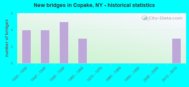
- New bridges - historical statistics
- 41930-1939
- 41940-1949
- 51950-1959
- 31960-1969
- 32010-2019

- Reconstructed bridges - Historical Statistics
- 11980-1989
- 11990-1999
- 12000-2009


- Bridge Condition - Deck
- 5.9%Very good
- 11.8%Good
- 41.2%Satisfactory
- 29.4%Fair
- 11.8%Poor

- Bridge Condition - Superstructure
- 5.9%Excellent
- 17.6%Very good
- 5.9%Good
- 41.2%Satisfactory
- 17.6%Fair
- 11.8%Serious

- Bridge Condition - Substructure
- 17.6%Very good
- 11.8%Good
- 35.3%Satisfactory
- 17.6%Fair
- 11.8%Poor
- 5.9%Critical

- Bridge Condition - Channel
- 5.3%Good
- 57.9%Satisfactory
- 21.1%Fair
- 15.8%Poor
Find on map >> Show street view
Structure Number: 101678, Location: 6.3 MI N DUT+COL CL (Lat: 42.094150, Lng: -73.542883), Route carried "on" structure: State highway 22, Year Built: 1945, Status: Open, Structure Length: 1.31m (4.30ft), Average Daily Traffic: 2,692 (year 2019), Truck Traffic: 11%, Average Future Daily Traffic: 2,717 (year 2040), Design Load: H 20, Features Intersected: NOSTER KILL
Minimum Vertical Clearance: 30+ m (98+ ft), Kilometerpoint: 10.185, Lanes on structure: 2, Base Highway Network: Yes, Owner: State Highway Agency, Approaching Roadway Width: 7.3m (24.0ft), Material/Design: Concrete, Design/Construction: Slab, Number Of Spans In Main Unit: 1, Length of Maximum Span: 11.6m (38.1ft), Curb-To-Curb Width: 11.5m (37.7ft), Out-to-Out Width: 12.4m (40.7ft)
Condition: Deck: Satisfactory, Superstructure: Satisfactory, Substructure: Satisfactory, Channel: Satisfactory, Operating Rating: 52.6 metric tons, Method Used To Determine Operating Rating: Load Factor (LF), Inventory Rating: 31.8 metric tons, Method Used To Determine Inventory Rating: Load Factor (LF), Structural Evaluation: Equal to present minimum criteria, Deck Geometry: Somewhat better than minimum adequacy, Waterway Adequacy: Equal to present desirable criteria, Approach Roadway Alignment: Meets minimum limits, Length Of Structure Improvement: 1.31m (4.30ft), Designated Inspection Frequency: Every 24 months, Inspection Date: April 2020, Bridge Improvement Cost: $693,000, Roadway Improvement Cost: $406,000, Total Project Cost: $1,099,000 ( Estimate for 2021), Wearing Surface/Protective System: Wearing Surface: Bituminous, Membrane: Other
Find on map >> Show street view
Structure Number: 101679, Location: 7.1 MI N DUT+COL CL (Lat: 42.105569, Lng: -73.540058), Route carried "on" structure: State highway 22, Year Built: 1945, Status: Open, Structure Length: 4.48m (14.70ft), Average Daily Traffic: 2,692 (year 2019), Truck Traffic: 11%, Average Future Daily Traffic: 2,717 (year 2040), Design Load: H 20, Features Intersected: BASH BISH BROOK
Minimum Vertical Clearance: 30+ m (98+ ft), Kilometerpoint: 11.472, Lanes on structure: 2, Base Highway Network: Yes, Owner: State Highway Agency, Approaching Roadway Width: 7.3m (24.0ft), Skew: 4 degrees, Material/Design: Steel, Design/Construction: Stringer/Multi-beam, Number Of Spans In Main Unit: 2, Length of Maximum Span: 21.9m (71.9ft), Curb-To-Curb Width: 9.2m (30.2ft), Out-to-Out Width: 11.0m (36.1ft)
Condition: Deck: Satisfactory, Superstructure: Serious, Substructure: Satisfactory, Channel: Satisfactory, Operating Rating: 54.4 metric tons, Method Used To Determine Operating Rating: Load Factor (LF), Inventory Rating: 32.7 metric tons, Method Used To Determine Inventory Rating: Load Factor (LF), Structural Evaluation: High priority of corrective action, Deck Geometry: Meets minimum limits, Waterway Adequacy: Equal to present desirable criteria, Approach Roadway Alignment: Meets minimum limits, Length Of Structure Improvement: 4.48m (14.70ft), Designated Inspection Frequency: Every 12 months, Inspection Date: August 2021, Bridge Improvement Cost: $2,474,000, Roadway Improvement Cost: $1,449,000, Total Project Cost: $3,922,000 ( Estimate for 2021), Deck Structure Type: Concrete Cast-file-Place, Wearing Surface/Protective System: Wearing Surface: Bituminous
Find on map >> Show street view
Structure Number: 101681, Location: .7 MI S JCT SH 22 & SH 23 (Lat: 42.170572, Lng: -73.517719), Route carried "on" structure: State highway 22, Year Built: 1939, Year Reconstructed: 1990, Status: Open, Structure Length: 2.26m (7.41ft), Average Daily Traffic: 4,440 (year 2020), Truck Traffic: 15%, Average Future Daily Traffic: 4,482 (year 2040), Design Load: H 20, Features Intersected: ROELIFF JANSEN KILL
Minimum Vertical Clearance: 30+ m (98+ ft), Kilometerpoint: 19.437, Lanes on structure: 2, Base Highway Network: Yes, Owner: State Highway Agency, Approaching Roadway Width: 7.9m (25.9ft), Skew: 1 degrees, Material/Design: Steel, Design/Construction: Stringer/Multi-beam, Number Of Spans In Main Unit: 1, Length of Maximum Span: 22.2m (72.8ft), Curb-To-Curb Width: 9.7m (31.8ft), Out-to-Out Width: 10.3m (33.8ft)
Condition: Deck: Satisfactory, Superstructure: Satisfactory, Substructure: Fair, Channel: Fair, Operating Rating: 94.3 metric tons, Method Used To Determine Operating Rating: Load Factor (LF), Inventory Rating: 56.2 metric tons, Method Used To Determine Inventory Rating: Load Factor (LF), Structural Evaluation: Somewhat better than minimum adequacy, Deck Geometry: Meets minimum limits, Waterway Adequacy: Equal to present desirable criteria, Approach Roadway Alignment: Meets minimum limits, Length Of Structure Improvement: 2.25m (7.38ft), Designated Inspection Frequency: Every 24 months, Inspection Date: April 2020, Bridge Improvement Cost: $1,240,000, Roadway Improvement Cost: $726,000, Total Project Cost: $1,967,000 ( Estimate for 2021), Deck Structure Type: Concrete Cast-file-Place, Wearing Surface/Protective System: Wearing Surface: Integral Concrete, Deck Protection: Epoxy Coated Reinforcing
Find on map >> Show street view
Structure Number: 101787, Location: 3.5 MI E JCT SH 23 & TSP (Lat: 42.175128, Lng: -73.581425), Route carried "on" structure: State highway 23, Year Built: 1959, Status: Open, Structure Length: 0.85m (2.79ft), Average Daily Traffic: 4,486 (year 2020), Truck Traffic: 10%, Average Future Daily Traffic: 4,982 (year 2040), Design Load: HS 20, Features Intersected: TRIBUTARY to TAGHKANIC C
Minimum Vertical Clearance: 30+ m (98+ ft), Kilometerpoint: 32.003, Lanes on structure: 2, Base Highway Network: Yes, Owner: State Highway Agency, Approaching Roadway Width: 10.4m (34.1ft), Material/Design: Concrete continuous, Design/Construction: Culvert, Number Of Spans In Main Unit: 2, Length of Maximum Span: 4.3m (14.1ft), Curb-To-Curb Width: 11.9m (39.0ft), Out-to-Out Width: 12.8m (42.0ft)
Condition: Channel: Fair, Culverts: Fair, Operating Rating: 57.7 metric tons, Method Used To Determine Operating Rating: Load and Resistance Factor Rating (LRFR) rating reported by rating factor(RF) method using HL-93 loadings, Inventory Rating: 44.4 metric tons, Method Used To Determine Inventory Rating: Load and Resistance Factor Rating (LRFR) rating reported by rating factor(RF) method using HL-93 loadings, Structural Evaluation: Somewhat better than minimum adequacy, Deck Geometry: Somewhat better than minimum adequacy, Waterway Adequacy: Meets minimum limits, Approach Roadway Alignment: Equal to present desirable criteria, Length Of Structure Improvement: 0.85m (2.79ft), Designated Inspection Frequency: Every 24 months, Inspection Date: March 2021, Bridge Improvement Cost: $660,000, Roadway Improvement Cost: $386,000, Total Project Cost: $1,046,000 ( Estimate for 2021)
Find on map >> Show street view
Structure Number: 101788, Location: 4.1 MI E JCT RTE23+TSP (Lat: 42.175622, Lng: -73.578494), Route carried "on" structure: State highway 23, Year Built: 1959, Status: Open, Structure Length: 1.52m (4.99ft), Average Daily Traffic: 4,486 (year 2020), Truck Traffic: 10%, Average Future Daily Traffic: 4,982 (year 2040), Design Load: HS 20, Features Intersected: TAGHKANIC CREEK
Minimum Vertical Clearance: 30+ m (98+ ft), Kilometerpoint: 32.663, Lanes on structure: 2, Base Highway Network: Yes, Owner: State Highway Agency, Approaching Roadway Width: 11.3m (37.1ft), Material/Design: Concrete continuous, Design/Construction: Culvert, Number Of Spans In Main Unit: 3, Length of Maximum Span: 4.5m (14.8ft), Curb-To-Curb Width: 11.9m (39.0ft), Out-to-Out Width: 12.8m (42.0ft)
Condition: Channel: Poor, Culverts: Fair, Operating Rating: 56.7 metric tons, Method Used To Determine Operating Rating: Load and Resistance Factor Rating (LRFR) rating reported by rating factor(RF) method using HL-93 loadings, Inventory Rating: 43.7 metric tons, Method Used To Determine Inventory Rating: Load and Resistance Factor Rating (LRFR) rating reported by rating factor(RF) method using HL-93 loadings, Structural Evaluation: Somewhat better than minimum adequacy, Deck Geometry: Somewhat better than minimum adequacy, Waterway Adequacy: Meets minimum limits, Approach Roadway Alignment: Equal to present desirable criteria, Length Of Structure Improvement: 1.52m (4.99ft), Designated Inspection Frequency: Every 24 months, Inspection Date: August 2020, Bridge Improvement Cost: $670,000, Roadway Improvement Cost: $392,000, Total Project Cost: $1,062,000 ( Estimate for 2021), Wearing Surface/Protective System: Wearing Surface: Bituminous
Find on map >> Show street view
Structure Number: 322231, Location: 1.3 MI SE OF WEST COPAKE (Lat: 42.081958, Lng: -73.563522), Route carried "on" structure: Other road , Year Built: 2010, Status: Open, Structure Length: 2.19m (7.19ft), Average Daily Traffic: 262 (year 2020), Truck Traffic: 8%, Average Future Daily Traffic: 367 (year 2040), Design Load: HS 25 or greater, Features Intersected: ROELIFF JANSEN KILL, Facility Carried by Structure: EMPIRE ROAD
Minimum Vertical Clearance: 30+ m (98+ ft), Kilometerpoint: 2.977, Lanes on structure: 2, Owner: County Highway Agency, Approaching Roadway Width: 8.5m (27.9ft), Skew: 2 degrees, Material/Design: Prestressed concrete, Design/Construction: Box Beam or Girders - Multiple, Number Of Spans In Main Unit: 1, Length of Maximum Span: 20.8m (68.2ft), Curb-To-Curb Width: 8.4m (27.6ft), Out-to-Out Width: 9.6m (31.5ft)
Condition: Deck: Good, Superstructure: Excellent, Substructure: Very good, Channel: Satisfactory, Operating Rating: 69.9 metric tons, Method Used To Determine Operating Rating: Load Factor (LF), Inventory Rating: 41.7 metric tons, Method Used To Determine Inventory Rating: Load Factor (LF), Structural Evaluation: Equal to present desirable criteria, Deck Geometry: Somewhat better than minimum adequacy, Waterway Adequacy: Better than present minimum criteria, Approach Roadway Alignment: Equal to present desirable criteria, Length Of Structure Improvement: 2.19m (7.19ft), Designated Inspection Frequency: Every 24 months, Inspection Date: November 2020, Bridge Improvement Cost: $561,000, Roadway Improvement Cost: $329,000, Total Project Cost: $890,000 ( Estimate for 2021), Wearing Surface/Protective System: Wearing Surface: Integral Concrete
Find on map >> Show street view
Structure Number: 322232, Location: 0.25 MI NW JCT CR 22 & Fa (Lat: 42.137994, Lng: -73.531089), Route carried "on" structure: Other road , Year Built: 1965, Year Reconstructed: 2012, Status: Open, Structure Length: 1.68m (5.51ft), Average Daily Traffic: 108 (year 2016), Truck Traffic: 8%, Average Future Daily Traffic: 151 (year 2036), Design Load: HL 93, Features Intersected: ROELIFF JANSEN KILL, Facility Carried by Structure: OVERLOOK ROAD
Minimum Vertical Clearance: 30+ m (98+ ft), Kilometerpoint: 0.097, Lanes on structure: 2, Owner: County Highway Agency, Approaching Roadway Width: 6.4m (21.0ft), Material/Design: Prestressed concrete, Design/Construction: Box Beam or Girders - Multiple, Number Of Spans In Main Unit: 1, Length of Maximum Span: 15.5m (50.9ft), Curb-To-Curb Width: 7.6m (24.9ft), Out-to-Out Width: 8.3m (27.2ft)
Condition: Deck: Very good, Superstructure: Very good, Substructure: Good, Channel: Satisfactory, Operating Rating: 79.8 metric tons, Method Used To Determine Operating Rating: Load Factor (LF), Inventory Rating: 48.1 metric tons, Method Used To Determine Inventory Rating: Load Factor (LF), Structural Evaluation: Better than present minimum criteria, Deck Geometry: Somewhat better than minimum adequacy, Waterway Adequacy: Somewhat better than minimum adequacy, Approach Roadway Alignment: Equal to present desirable criteria, Length Of Structure Improvement: 1.67m (5.48ft), Designated Inspection Frequency: Every 24 months, Inspection Date: October 2020, Bridge Improvement Cost: $475,000, Roadway Improvement Cost: $278,000, Total Project Cost: $754,000 ( Estimate for 2021), Wearing Surface/Protective System: Wearing Surface: Bituminous
Find on map >> Show street view
Structure Number: 322233, Location: .3 MI W INT TWIN BR &FARM (Lat: 42.134053, Lng: -73.537025), Route carried "on" structure: Other road , Year Built: 1939, Status: Open, Structure Length: 1.52m (4.99ft), Average Daily Traffic: 452 (year 2020), Truck Traffic: 8%, Average Future Daily Traffic: 633 (year 2040), Design Load: H 15, Features Intersected: ROELIFF JANSEN KL, Facility Carried by Structure: TWIN BRIDGES ROAD
Minimum Vertical Clearance: 30+ m (98+ ft), Kilometerpoint: 1.931, Lanes on structure: 2, Owner: County Highway Agency, Approaching Roadway Width: 5.8m (19.0ft), Material/Design: Steel, Design/Construction: Stringer/Multi-beam, Number Of Spans In Main Unit: 1, Length of Maximum Span: 14.6m (47.9ft), Curb-To-Curb Width: 7.4m (24.3ft), Out-to-Out Width: 8.2m (26.9ft)
Condition: Deck: Satisfactory, Superstructure: Satisfactory, Substructure: Fair, Channel: Fair, Operating Rating: 14.6 metric tons, Method Used To Determine Operating Rating: Load and Resistance Factor Rating (LRFR) rating reported by rating factor(RF) method using HL-93 loadings, Inventory Rating: 11.3 metric tons, Method Used To Determine Inventory Rating: Load and Resistance Factor Rating (LRFR) rating reported by rating factor(RF) method using HL-93 loadings, Structural Evaluation: Meets minimum limits, Deck Geometry: Meets minimum limits, Waterway Adequacy: Meets minimum limits, Approach Roadway Alignment: Better than present minimum criteria, Length Of Structure Improvement: 1.52m (4.99ft), Designated Inspection Frequency: Every 24 months, Inspection Date: August 2020, Bridge Improvement Cost: $637,000, Roadway Improvement Cost: $373,000, Total Project Cost: $1,010,000 ( Estimate for 2021), Deck Structure Type: Concrete Cast-file-Place, Wearing Surface/Protective System: Wearing Surface: Bituminous
Find on map >> Show street view
Structure Number: 322235, Location: 1.7 MI SE OF WEST COPAKE (Lat: 42.081644, Lng: -73.553417), Route carried "on" structure: Other road , Year Built: 1960, Status: Open, Structure Length: 1.04m (3.41ft), Average Daily Traffic: 59 (year 2015), Truck Traffic: 8%, Average Future Daily Traffic: 83 (year 2035), Design Load: H 20, Features Intersected: BASHBISH BROOK, Facility Carried by Structure: TROUT BROOK RD
Minimum Vertical Clearance: 30+ m (98+ ft), Kilometerpoint: 0.998, Lanes on structure: 2, Owner: County Highway Agency, Approaching Roadway Width: 5.8m (19.0ft), Material/Design: Prestressed concrete, Design/Construction: Box Beam or Girders - Multiple, Number Of Spans In Main Unit: 1, Length of Maximum Span: 10.0m (32.8ft), Curb-To-Curb Width: 7.8m (25.6ft), Out-to-Out Width: 8.2m (26.9ft)
Condition: Deck: Good, Superstructure: Satisfactory, Substructure: Satisfactory, Channel: Satisfactory, Operating Rating: 68.9 metric tons, Method Used To Determine Operating Rating: Load Factor (LF), Inventory Rating: 40.8 metric tons, Method Used To Determine Inventory Rating: Load Factor (LF), Structural Evaluation: Equal to present minimum criteria, Deck Geometry: Equal to present minimum criteria, Waterway Adequacy: Meets minimum limits, Approach Roadway Alignment: Equal to present minimum criteria, Length Of Structure Improvement: 1.03m (3.38ft), Designated Inspection Frequency: Every 24 months, Inspection Date: July 2020, Bridge Improvement Cost: $368,000, Roadway Improvement Cost: $215,000, Total Project Cost: $583,000 ( Estimate for 2021), Wearing Surface/Protective System: Wearing Surface: Bituminous
Find on map >> Show street view
Structure Number: 322236, Location: .2 MI W INT TWIN BR FARM (Lat: 42.133814, Lng: -73.535944), Route carried "on" structure: Other road , Year Built: 1939, Status: Open, Structure Length: 0.91m (2.99ft), Average Daily Traffic: 452 (year 2020), Truck Traffic: 8%, Average Future Daily Traffic: 633 (year 2040), Design Load: H 15, Features Intersected: ROE JAN OVERFLOW, Facility Carried by Structure: TWIN BRIDGES ROAD
Minimum Vertical Clearance: 30+ m (98+ ft), Kilometerpoint: 2.043, Lanes on structure: 2, Owner: County Highway Agency, Approaching Roadway Width: 6.7m (22.0ft), Material/Design: Steel, Design/Construction: Stringer/Multi-beam, Number Of Spans In Main Unit: 1, Length of Maximum Span: 8.5m (27.9ft), Curb-To-Curb Width: 7.3m (24.0ft), Out-to-Out Width: 8.2m (26.9ft)
Condition: Deck: Fair, Superstructure: Satisfactory, Substructure: Critical, Channel: Poor, Operating Rating: 46.0 metric tons, Method Used To Determine Operating Rating: Load and Resistance Factor Rating (LRFR) rating reported by rating factor(RF) method using HL-93 loadings, Inventory Rating: 35.3 metric tons, Method Used To Determine Inventory Rating: Load and Resistance Factor Rating (LRFR) rating reported by rating factor(RF) method using HL-93 loadings, Structural Evaluation: High priority of replacement, Deck Geometry: Meets minimum limits, Waterway Adequacy: Meets minimum limits, Approach Roadway Alignment: Better than present minimum criteria, Length Of Structure Improvement: 0.91m (2.99ft), Designated Inspection Frequency: Every 24 months, Underwater Inspection Frequency: Every 60 months, Inspection Date: July 2021, Underwater Inspection Date: July 2021, Bridge Improvement Cost: $465,000, Roadway Improvement Cost: $272,000, Total Project Cost: $737,000 ( Estimate for 2021), Deck Structure Type: Concrete Cast-file-Place, Wearing Surface/Protective System: Wearing Surface: Bituminous
Find on map >> Show street view
Structure Number: 322237, Location: 0.4 MI S OF COPAKE FALLS (Lat: 42.114594, Lng: -73.527542), Route carried "on" structure: Other road , Year Built: 1957, Status: Open, Structure Length: 2.71m (8.89ft), Average Daily Traffic: 50 (year 2018), Truck Traffic: 8%, Average Future Daily Traffic: 70 (year 2038), Features Intersected: BASHBISH BROOK, Facility Carried by Structure: MAPLE LANE
Minimum Vertical Clearance: 30+ m (98+ ft), Kilometerpoint: 0.370, Lanes on structure: 1, Owner: County Highway Agency, Approaching Roadway Width: 3.0m (9.8ft), Material/Design: Steel continuous, Design/Construction: Stringer/Multi-beam, Number Of Spans In Main Unit: 2, Length of Maximum Span: 13.4m (44.0ft), Curb-To-Curb Width: 3.3m (10.8ft), Out-to-Out Width: 3.8m (12.5ft)
Condition: Deck: Fair, Superstructure: Satisfactory, Substructure: Good, Channel: Satisfactory, Operating Rating: 42.6 metric tons, Method Used To Determine Operating Rating: Load Factor (LF), Inventory Rating: 25.4 metric tons, Method Used To Determine Inventory Rating: Load Factor (LF), Structural Evaluation: Equal to present minimum criteria, Deck Geometry: High priority of replacement, Waterway Adequacy: Somewhat better than minimum adequacy, Approach Roadway Alignment: Meets minimum limits, Length Of Structure Improvement: 2.71m (8.89ft), Designated Inspection Frequency: Every 24 months, Critical Feature Inspection Frequency: Every 24 months, Inspection Date: May 2020, Critical Feature Inspection Date: May 2020, Bridge Improvement Cost: $546,000, Roadway Improvement Cost: $320,000, Total Project Cost: $866,000 ( Estimate for 2021), Deck Structure Type: Open Grating, Wearing Surface/Protective System: Wearing Surface: Other
Find on map >> Show street view
Structure Number: 322239, Location: AT COPAKE FALLS (Lat: 42.119933, Lng: -73.517983), Route carried "on" structure: Other road , Year Built: 1956, Status: Posted for load, Structure Length: 3.66m (12.01ft), Average Daily Traffic: 270 (year 2020), Truck Traffic: 8%, Average Future Daily Traffic: 378 (year 2040), Features Intersected: BASHBISH BROOK, Facility Carried by Structure: VALLEY VIEW ROAD
Minimum Vertical Clearance: 30+ m (98+ ft), Kilometerpoint: 2.864, Lanes on structure: 2, Owner: County Highway Agency, Approaching Roadway Width: 5.2m (17.1ft), Skew: 3 degrees, Material/Design: Steel, Design/Construction: Stringer/Multi-beam, Number Of Spans In Main Unit: 2, Length of Maximum Span: 17.9m (58.7ft), Curb-To-Curb Width: 6.1m (20.0ft), Out-to-Out Width: 6.9m (22.6ft)
Condition: Deck: Poor, Superstructure: Serious, Substructure: Poor, Channel: Satisfactory, Operating Rating: 20.9 metric tons, Method Used To Determine Operating Rating: Load Factor (LF), Inventory Rating: 11.8 metric tons, Method Used To Determine Inventory Rating: Load Factor (LF), Structural Evaluation: High priority of corrective action, Deck Geometry: Meets minimum limits, Waterway Adequacy: Equal to present desirable criteria, Approach Roadway Alignment: Equal to present minimum criteria, Bridge Posting: Required (Relationship of Operating Rating to Maximum Legal Load: > 39.9% below), Length Of Structure Improvement: 3.65m (11.98ft), Designated Inspection Frequency: Every 12 months, Inspection Date: May 2021, Bridge Improvement Cost: $1,192,000, Roadway Improvement Cost: $698,000, Total Project Cost: $1,890,000 ( Estimate for 2021), Deck Structure Type: Open Grating, Wearing Surface/Protective System: Wearing Surface: Other
Find on map >> Show street view
Structure Number: 334212, Location: 0.7 MI E OF WEST COPAKE (Lat: 42.096833, Lng: -73.568344), Route carried "on" structure: County highway , Year Built: 2016, Status: Open, Structure Length: 2.62m (8.60ft), Truck Traffic: 10%, Design Load: HL 93, Features Intersected: ROELIFF JANSEN KILL, Facility Carried by Structure: COUNTY ROAD 7A
Minimum Vertical Clearance: 30+ m (98+ ft), Kilometerpoint: 8.335, Lanes on structure: 2, Owner: County Highway Agency, Approaching Roadway Width: 9.1m (29.9ft), Skew: 3 degrees, Material/Design: Prestressed concrete, Design/Construction: Box Beam or Girders - Multiple, Number Of Spans In Main Unit: 1, Length of Maximum Span: 25.0m (82.0ft), Curb-To-Curb Width: 9.1m (29.9ft), Out-to-Out Width: 10.1m (33.1ft)
Condition: Deck: Fair, Superstructure: Very good, Substructure: Very good, Channel: Satisfactory, Operating Rating: 69.7 metric tons, Method Used To Determine Operating Rating: Load and Resistance Factor Rating (LRFR) rating reported by rating factor(RF) method using HL-93 loadings, Inventory Rating: 53.5 metric tons, Method Used To Determine Inventory Rating: Load and Resistance Factor Rating (LRFR) rating reported by rating factor(RF) method using HL-93 loadings, Structural Evaluation: Equal to present desirable criteria, Deck Geometry: Better than present minimum criteria, Waterway Adequacy: Meets minimum limits, Approach Roadway Alignment: Equal to present desirable criteria, Length Of Structure Improvement: 2.62m (8.60ft), Designated Inspection Frequency: Every 24 months, Inspection Date: October 2020, Bridge Improvement Cost: $696,000, Roadway Improvement Cost: $408,000, Total Project Cost: $1,104,000 ( Estimate for 2021), Wearing Surface/Protective System: Wearing Surface: Integral Concrete
Find on map >> Show street view
Structure Number: 334215, Location: 1.65 MI NW JCT Rt.22 & CR (Lat: 42.113178, Lng: -73.563264), Route carried "on" structure: County highway , Year Built: 2011, Status: Open, Structure Length: 2.56m (8.40ft), Average Daily Traffic: 1,814 (year 2017), Truck Traffic: 4%, Average Future Daily Traffic: 1,892 (year 2040), Design Load: HS 25 or greater, Features Intersected: ROELIFF JANSEN KILL, Facility Carried by Structure: COUNTY ROAD 7A
Minimum Vertical Clearance: 30+ m (98+ ft), Kilometerpoint: 1.287, Lanes on structure: 2, Owner: County Highway Agency, Approaching Roadway Width: 6.7m (22.0ft), Material/Design: Prestressed concrete, Design/Construction: Stringer/Multi-beam, Number Of Spans In Main Unit: 1, Length of Maximum Span: 24.4m (80.1ft), Curb-To-Curb Width: 9.6m (31.5ft), Out-to-Out Width: 10.0m (32.8ft)
Condition: Deck: Satisfactory, Superstructure: Very good, Substructure: Very good, Channel: Good, Operating Rating: 68.9 metric tons, Method Used To Determine Operating Rating: Load Factor (LF), Inventory Rating: 40.8 metric tons, Method Used To Determine Inventory Rating: Load Factor (LF), Structural Evaluation: Equal to present desirable criteria, Deck Geometry: Somewhat better than minimum adequacy, Waterway Adequacy: Equal to present minimum criteria, Approach Roadway Alignment: Equal to present minimum criteria, Length Of Structure Improvement: 2.56m (8.40ft), Designated Inspection Frequency: Every 24 months, Underwater Inspection Frequency: Every 60 months, Inspection Date: August 2020, Underwater Inspection Date: September 2019, Bridge Improvement Cost: $1,493,000, Roadway Improvement Cost: $874,000, Total Project Cost: $2,367,000 ( Estimate for 2021), Deck Structure Type: Concrete Cast-file-Place, Wearing Surface/Protective System: Wearing Surface: Integral Concrete, Deck Protection: Epoxy Coated Reinforcing
Find on map >> Show street view
Structure Number: 334229, Location: 0.4 MI S OF CRARYVILLE (Lat: 42.169508, Lng: -73.581208), Route carried "on" structure: County highway , Year Built: 1949, Year Reconstructed: 1993, Status: Open, Structure Length: 1.40m (4.59ft), Average Daily Traffic: 2,105 (year 2015), Truck Traffic: 4%, Average Future Daily Traffic: 2,195 (year 2040), Design Load: HS 25 or greater, Features Intersected: TAGHKANIC CREEK, Facility Carried by Structure: COUNTY ROAD 7
Minimum Vertical Clearance: 30+ m (98+ ft), Kilometerpoint: 0.611, Lanes on structure: 2, Owner: County Highway Agency, Approaching Roadway Width: 6.7m (22.0ft), Material/Design: Prestressed concrete, Design/Construction: Stringer/Multi-beam, Number Of Spans In Main Unit: 1, Length of Maximum Span: 13.4m (44.0ft), Curb-To-Curb Width: 8.8m (28.9ft), Out-to-Out Width: 9.4m (30.8ft)
Condition: Deck: Fair, Superstructure: Good, Substructure: Satisfactory, Channel: Satisfactory, Operating Rating: 76.2 metric tons, Method Used To Determine Operating Rating: Load Factor (LF), Inventory Rating: 45.4 metric tons, Method Used To Determine Inventory Rating: Load Factor (LF), Structural Evaluation: Equal to present minimum criteria, Deck Geometry: Meets minimum limits, Waterway Adequacy: Meets minimum limits, Approach Roadway Alignment: Equal to present desirable criteria, Length Of Structure Improvement: 1.40m (4.59ft), Designated Inspection Frequency: Every 24 months, Inspection Date: July 2021, Bridge Improvement Cost: $453,000, Roadway Improvement Cost: $265,000, Total Project Cost: $719,000 ( Estimate for 2021), Deck Structure Type: Concrete Cast-file-Place, Wearing Surface/Protective System: Wearing Surface: Monolithic Concrete, Deck Protection: Epoxy Coated Reinforcing
Find on map >> Show street view
Structure Number: 334241, Location: AT CRARYVILLE (Lat: 42.173908, Lng: -73.582717), Route carried "on" structure: County highway , Year Built: 1939, Status: Open, Structure Length: 1.22m (4.00ft), Average Daily Traffic: 2,105 (year 2015), Truck Traffic: 4%, Average Future Daily Traffic: 2,195 (year 2040), Design Load: H 20, Features Intersected: STILL CREEK, Facility Carried by Structure: COUNTY ROAD 7
Minimum Vertical Clearance: 30+ m (98+ ft), Kilometerpoint: 0.193, Lanes on structure: 2, Owner: County Highway Agency, Approaching Roadway Width: 7.3m (24.0ft), Material/Design: Steel, Design/Construction: Stringer/Multi-beam, Number Of Spans In Main Unit: 1, Length of Maximum Span: 11.5m (37.7ft), Curb-To-Curb Width: 8.5m (27.9ft), Out-to-Out Width: 9.4m (30.8ft)
Condition: Deck: Poor, Superstructure: Fair, Substructure: Poor, Channel: Poor, Operating Rating: 45.7 metric tons, Method Used To Determine Operating Rating: Load and Resistance Factor Rating (LRFR) rating reported by rating factor(RF) method using HL-93 loadings, Inventory Rating: 35.0 metric tons, Method Used To Determine Inventory Rating: Load and Resistance Factor Rating (LRFR) rating reported by rating factor(RF) method using HL-93 loadings, Structural Evaluation: Meets minimum limits, Deck Geometry: Meets minimum limits, Waterway Adequacy: Meets minimum limits, Approach Roadway Alignment: Better than present minimum criteria, Length Of Structure Improvement: 1.21m (3.97ft), Designated Inspection Frequency: Every 24 months, Inspection Date: September 2021, Bridge Improvement Cost: $672,000, Roadway Improvement Cost: $394,000, Total Project Cost: $1,066,000 ( Estimate for 2021), Deck Structure Type: Concrete Cast-file-Place, Wearing Surface/Protective System: Wearing Surface: Bituminous
Find on map >> Show street view
Structure Number: 33426, Location: AT COPAKE (Lat: 42.102103, Lng: -73.548569), Route carried "on" structure: County highway , Year Built: 1956, Status: Open, Structure Length: 2.16m (7.09ft), Average Daily Traffic: 1,480 (year 2020), Truck Traffic: 7%, Average Future Daily Traffic: 1,543 (year 2040), Features Intersected: BASHBISH BROOK, Facility Carried by Structure: COUNTY ROAD 7A
Minimum Vertical Clearance: 30+ m (98+ ft), Kilometerpoint: 1.078, Lanes on structure: 2, Owner: County Highway Agency, Approaching Roadway Width: 8.5m (27.9ft), Skew: 2 degrees, Material/Design: Steel, Design/Construction: Stringer/Multi-beam, Number Of Spans In Main Unit: 1, Length of Maximum Span: 20.7m (67.9ft), Curb or Sidewalk Widths: Left: 1.6m (5.2ft), Right: 0.0m, Curb-To-Curb Width: 8.5m (27.9ft), Out-to-Out Width: 10.7m (35.1ft)
Condition: Deck: Satisfactory, Superstructure: Fair, Substructure: Satisfactory, Channel: Fair, Operating Rating: 58.1 metric tons, Method Used To Determine Operating Rating: Load Factor (LF), Inventory Rating: 34.5 metric tons, Method Used To Determine Inventory Rating: Load Factor (LF), Structural Evaluation: Somewhat better than minimum adequacy, Deck Geometry: Somewhat better than minimum adequacy, Waterway Adequacy: Meets minimum limits, Approach Roadway Alignment: Better than present minimum criteria, Length Of Structure Improvement: 2.16m (7.09ft), Designated Inspection Frequency: Every 24 months, Inspection Date: July 2020, Bridge Improvement Cost: $1,243,000, Roadway Improvement Cost: $728,000, Total Project Cost: $1,970,000 ( Estimate for 2021), Deck Structure Type: Concrete Cast-file-Place, Wearing Surface/Protective System: Wearing Surface: Bituminous
Find on map >> Show street view
Structure Number: 334261, Location: 0.5 MI SE OF COPAKE (Lat: 42.097056, Lng: -73.544789), Route carried "on" structure: County highway , Year Built: 1962, Status: Open, Structure Length: 1.16m (3.81ft), Average Daily Traffic: 1,480 (year 2020), Truck Traffic: 7%, Average Future Daily Traffic: 1,543 (year 2040), Features Intersected: NOSTER KILL, Facility Carried by Structure: COUNTY ROAD 7A
Minimum Vertical Clearance: 30+ m (98+ ft), Kilometerpoint: 0.434, Lanes on structure: 2, Owner: County Highway Agency, Approaching Roadway Width: 7.9m (25.9ft), Skew: 4 degrees, Material/Design: Prestressed concrete, Design/Construction: Box Beam or Girders - Multiple, Number Of Spans In Main Unit: 1, Length of Maximum Span: 11.2m (36.7ft), Curb-To-Curb Width: 7.9m (25.9ft), Out-to-Out Width: 8.3m (27.2ft)
Condition: Deck: Fair, Superstructure: Fair, Substructure: Fair, Channel: Satisfactory, Operating Rating: 63.5 metric tons, Method Used To Determine Operating Rating: Load and Resistance Factor Rating (LRFR) rating reported by rating factor(RF) method using HL-93 loadings, Inventory Rating: 48.9 metric tons, Method Used To Determine Inventory Rating: Load and Resistance Factor Rating (LRFR) rating reported by rating factor(RF) method using HL-93 loadings, Structural Evaluation: Somewhat better than minimum adequacy, Deck Geometry: Meets minimum limits, Waterway Adequacy: Meets minimum limits, Approach Roadway Alignment: Equal to present minimum criteria, Length Of Structure Improvement: 1.15m (3.77ft), Designated Inspection Frequency: Every 24 months, Inspection Date: May 2020, Bridge Improvement Cost: $407,000, Roadway Improvement Cost: $239,000, Total Project Cost: $646,000 ( Estimate for 2021), Wearing Surface/Protective System: Wearing Surface: Bituminous
Find on map >> Show street view
Structure Number: 552185, Location: 0.9 MI E OF COPAKE FALLS (Lat: 42.116644, Lng: -73.507639), Route carried "on" structure: State lands road , Year Built: 1940, Status: Open, Structure Length: 1.10m (3.61ft), Truck Traffic: 10%, Features Intersected: BASH BISH BROOK, Facility Carried by Structure: CABIN ROAD
Minimum Vertical Clearance: 30+ m (98+ ft), Kilometerpoint: 0.145, Lanes on structure: 1, Owner: State Agenciy, Approaching Roadway Width: 3.4m (11.2ft), Material/Design: Steel, Design/Construction: Stringer/Multi-beam, Number Of Spans In Main Unit: 1, Length of Maximum Span: 10.3m (33.8ft), Curb-To-Curb Width: 3.0m (9.8ft), Out-to-Out Width: 3.4m (11.2ft)
Condition: Deck: Satisfactory, Superstructure: Satisfactory, Substructure: Satisfactory, Channel: Satisfactory, Operating Rating: 42.8 metric tons, Method Used To Determine Operating Rating: Load and Resistance Factor Rating (LRFR) rating reported by rating factor(RF) method using HL-93 loadings, Inventory Rating: 33.0 metric tons, Method Used To Determine Inventory Rating: Load and Resistance Factor Rating (LRFR) rating reported by rating factor(RF) method using HL-93 loadings, Structural Evaluation: Equal to present minimum criteria, Deck Geometry: High priority of replacement, Waterway Adequacy: Meets minimum limits, Approach Roadway Alignment: High priority of corrective action, Length Of Structure Improvement: 1.09m (3.58ft), Designated Inspection Frequency: Every 24 months, Critical Feature Inspection Frequency: Every 24 months, Inspection Date: August 2020, Critical Feature Inspection Date: August 2020, Bridge Improvement Cost: $239,000, Roadway Improvement Cost: $140,000, Total Project Cost: $378,000 ( Estimate for 2021), Deck Structure Type: Concrete Cast-file-Place, Wearing Surface/Protective System: Wearing Surface: Integral Concrete