Bridge Statistics for Copper City, Michigan (MI)
Condition, Traffic, Stress, Structural Evaluation, Project Costs
- National Bridge Inventory (NBI) Statistics
- 30Number of bridges
- 213ft / 65.1mTotal length
- $987,000Total costs
- 81,459Total average daily traffic
- 4,737Total average daily truck traffic
- 145,874Total future (year 2010) average daily traffic
- National Bridge Inventory (NBI) Registered Bridges for Copper City
- No street view available for this location
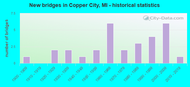
- New bridges - historical statistics
- 11900-1909
- 21920-1929
- 21930-1939
- 11940-1949
- 21950-1959
- 61960-1969
- 21970-1979
- 31980-1989
- 41990-1999
- 62000-2009
- 12010-2019

- Reconstructed bridges - Historical Statistics
- 11960-1969
- 11970-1979
- 01980-1989
- 11990-1999
- 12000-2009


- Bridge Condition - Deck
- 28.6%Very good
- 32.1%Good
- 17.9%Satisfactory
- 10.7%Fair
- 10.7%Poor

- Bridge Condition - Superstructure
- 21.4%Very good
- 21.4%Good
- 17.9%Satisfactory
- 21.4%Fair
- 17.9%Poor

- Bridge Condition - Substructure
- 21.4%Very good
- 35.7%Good
- 17.9%Satisfactory
- 21.4%Fair
- 3.6%Serious

- Bridge Condition - Channel
- 34.5%Very good
- 24.1%Good
- 24.1%Satisfactory
- 6.9%Fair
- 10.3%Poor
Find on map >> Show street view
Structure Number: 352, Location: 2.3 MI S & 1 MI W BOLTON (Lat: 45.147197, Lng: -83.608667), Route carried "on" structure: County highway , Year Built: 1984, Status: Open, Structure Length: 1.52m (4.99ft), Average Daily Traffic: 150 (year 2010), Average Future Daily Traffic: 200 (year 2010), Design Load: HS 20, Features Intersected: N BR THUNDER BAY RIVER, Facility Carried by Structure: METZKE ROAD
Minimum Vertical Clearance: 30.48m (100.00ft), Kilometerpoint: 1.379, Lanes on structure: 2, Owner: County Highway Agency, Approaching Roadway Width: 9.1m (29.9ft), Material/Design: Prestressed concrete, Design/Construction: Box Beam or Girders - Multiple, Number Of Spans In Main Unit: 1, Length of Maximum Span: 14.0m (45.9ft), Curb-To-Curb Width: 9.8m (32.2ft), Out-to-Out Width: 10.4m (34.1ft)
Condition: Deck: Very good, Superstructure: Satisfactory, Substructure: Good, Channel: Satisfactory, Operating Rating: 35.5 metric tons, Method Used To Determine Operating Rating: Load Factor (LF), Inventory Rating: 32.7 metric tons, Method Used To Determine Inventory Rating: Load Factor (LF), Structural Evaluation: Equal to present minimum criteria, Deck Geometry: Better than present minimum criteria, Waterway Adequacy: Better than present minimum criteria, Approach Roadway Alignment: Equal to present desirable criteria, Designated Inspection Frequency: Every 24 months, Inspection Date: August 2020, Deck Structure Type: Concrete Precast Panels, Wearing Surface/Protective System: Wearing Surface: Bituminous, Deck Protection: Epoxy Coated Reinforcing
Find on map >> Show street view
Structure Number: 3079, Location: 1.5 MI N OF CLINTON COL (Lat: 43.139042, Lng: -84.563469), Route carried "on" structure: US 127, Year Built: 1955, Status: Open, Structure Length: 3.94m (12.93ft), Average Daily Traffic: 16,500 (year 2015), Truck Traffic: 8%, Average Future Daily Traffic: 18,975 (year 2035), Design Load: HS 20, Features Intersected: MAPLE RIVER
Minimum Vertical Clearance: 30.48m (100.00ft), Kilometerpoint: 2.400, Lanes on structure: 2, Base Highway Network: Yes (Inventory Route: 49, Subroute: 2), Owner: State Highway Agency, Approaching Roadway Width: 11.6m (38.1ft), Skew: 10 degrees, Material/Design: Steel, Design/Construction: Stringer/Multi-beam, Number Of Spans In Main Unit: 2, Length of Maximum Span: 19.8m (65.0ft), Curb or Sidewalk Widths: Left: 0.4m (1.3ft), Right: 0.4m (1.3ft), Curb-To-Curb Width: 9.1m (29.9ft), Out-to-Out Width: 10.8m (35.4ft)
Condition: Deck: Poor, Superstructure: Poor, Substructure: Fair, Channel: Good, Operating Rating: 80.4 metric tons, Method Used To Determine Operating Rating: Load Factor (LF) rating reported by rating factor (RF) method using MS18 loading, Inventory Rating: 42.8 metric tons, Method Used To Determine Inventory Rating: Load Factor (LF) rating reported by rating factor (RF) method using MS18 loading, Structural Evaluation: Meets minimum limits, Deck Geometry: Meets minimum limits, Waterway Adequacy: Equal to present desirable criteria, Approach Roadway Alignment: Equal to present desirable criteria, Designated Inspection Frequency: Every 24 months, Inspection Date: July 2021, Deck Structure Type: Concrete Cast-file-Place, Wearing Surface/Protective System: Wearing Surface: Bituminous, Membrane: Preformed Fabric
Find on map >> Show street view
Structure Number: 3081, Location: 5.3 MI SE OF ITHACA (Lat: 43.244392, Lng: -84.563358), Route carried "on" structure: US 127, Year Built: 1957, Status: Open, Structure Length: 1.18m (3.87ft), Average Daily Traffic: 9,134 (year 2007), Truck Traffic: 9%, Average Future Daily Traffic: 11,067 (year 2018), Design Load: HS 20+Mod, Features Intersected: N BR BAD RIVER
Minimum Vertical Clearance: 30.48m (100.00ft), Kilometerpoint: 14.068, Lanes on structure: 2, Base Highway Network: Yes (Inventory Route: 49, Subroute: 2), Owner: State Highway Agency, Approaching Roadway Width: 12.8m (42.0ft), Skew: 4 degrees, Material/Design: Concrete, Design/Construction: Tee Beam, Number Of Spans In Main Unit: 1, Length of Maximum Span: 11.8m (38.7ft), Curb or Sidewalk Widths: Left: 0.4m (1.3ft), Right: 0.4m (1.3ft), Curb-To-Curb Width: 12.8m (42.0ft), Out-to-Out Width: 14.5m (47.6ft)
Condition: Deck: Satisfactory, Superstructure: Fair, Substructure: Satisfactory, Channel: Poor, Operating Rating: 64.2 metric tons, Method Used To Determine Operating Rating: Load Factor (LF) rating reported by rating factor (RF) method using MS18 loading, Inventory Rating: 38.2 metric tons, Method Used To Determine Inventory Rating: Load Factor (LF) rating reported by rating factor (RF) method using MS18 loading, Structural Evaluation: Somewhat better than minimum adequacy, Deck Geometry: Equal to present desirable criteria, Waterway Adequacy: High priority of corrective action, Approach Roadway Alignment: Equal to present desirable criteria, Designated Inspection Frequency: Every 24 months, Inspection Date: May 2021, Deck Structure Type: Concrete Cast-file-Place, Wearing Surface/Protective System: Wearing Surface: Bituminous
Find on map >> Show street view
Structure Number: 3082, Location: 0.5 MI W OF ST LOUIS (Lat: 43.396661, Lng: -84.632083), Route carried "on" structure: US 127, Year Built: 1961, Status: Open, Structure Length: 4.63m (15.19ft), Average Daily Traffic: 8,293 (year 2007), Truck Traffic: 8%, Average Future Daily Traffic: 11,739 (year 2018), Design Load: HS 20, Features Intersected: PINE RIVER
Minimum Vertical Clearance: 30.48m (100.00ft), Kilometerpoint: 33.195, Lanes on structure: 2, Base Highway Network: Yes (Inventory Route: 49, Subroute: 3), Owner: State Highway Agency, Approaching Roadway Width: 17.7m (58.1ft), Skew: 12 degrees, Material/Design: Steel, Design/Construction: Stringer/Multi-beam, Number Of Spans In Main Unit: 3, Length of Maximum Span: 15.5m (50.9ft), Curb-To-Curb Width: 13.4m (44.0ft), Out-to-Out Width: 14.3m (46.9ft)
Condition: Deck: Fair, Superstructure: Satisfactory, Substructure: Satisfactory, Channel: Very good, Operating Rating: 60.6 metric tons, Method Used To Determine Operating Rating: Load Factor (LF) rating reported by rating factor (RF) method using MS18 loading, Inventory Rating: 36.3 metric tons, Method Used To Determine Inventory Rating: Load Factor (LF) rating reported by rating factor (RF) method using MS18 loading, Structural Evaluation: Equal to present minimum criteria, Deck Geometry: Superior to present desirable criteria, Waterway Adequacy: Better than present minimum criteria, Approach Roadway Alignment: Better than present minimum criteria, Designated Inspection Frequency: Every 24 months, Underwater Inspection Frequency: Every 60 months, Other Special Inspection Frequency: Every 12 months, Inspection Date: June 2021, Underwater Inspection Date: September 2020, Other Special Inspection Date: June 2021, Deck Structure Type: Concrete Cast-file-Place, Wearing Surface/Protective System: Wearing Surface: Epoxy Overlay
Find on map >> Show street view
Structure Number: 3145, Location: SEC 36 SEVILLE TWP (Lat: 43.379256, Lng: -84.739639), Route carried "on" structure: County highway 2974, Year Built: 1930, Status: Open, Structure Length: 0.85m (2.79ft), Average Daily Traffic: 4,800 (year 2003), Average Future Daily Traffic: 6,480 (year 2023), Design Load: HS 20+Mod, Features Intersected: DRAIN #96, Facility Carried by Structure: LINCOLN ROAD
Minimum Vertical Clearance: 30.48m (100.00ft), Kilometerpoint: 29.965, Lanes on structure: 2, Owner: County Highway Agency, Approaching Roadway Width: 9.1m (29.9ft), Skew: 2 degrees, Material/Design: Concrete, Design/Construction: Tee Beam, Number Of Spans In Main Unit: 1, Length of Maximum Span: 8.2m (26.9ft), Curb-To-Curb Width: 7.9m (25.9ft), Out-to-Out Width: 8.6m (28.2ft)
Condition: Deck: Fair, Superstructure: Fair, Substructure: Fair, Channel: Good, Operating Rating: 48.6 metric tons, Method Used To Determine Operating Rating: Load Factor (LF) rating reported by rating factor (RF) method using MS18 loading, Inventory Rating: 29.2 metric tons, Method Used To Determine Inventory Rating: Load Factor (LF) rating reported by rating factor (RF) method using MS18 loading, Structural Evaluation: Somewhat better than minimum adequacy, Deck Geometry: High priority of corrective action, Waterway Adequacy: Better than present minimum criteria, Approach Roadway Alignment: Better than present minimum criteria, Designated Inspection Frequency: Every 24 months, Inspection Date: June 2021, Deck Structure Type: Concrete Cast-file-Place, Wearing Surface/Protective System: Wearing Surface: Bituminous
Find on map >> Show street view
Structure Number: 3146, Location: SEC 32 PINE RIVER TWP (Lat: 43.379139, Lng: -84.705783), Route carried "on" structure: County highway 2974, Year Built: 1930, Status: Open, Structure Length: 1.12m (3.67ft), Average Daily Traffic: 4,800 (year 2003), Average Future Daily Traffic: 6,480 (year 2023), Design Load: HS 20+Mod, Features Intersected: DRAIN #73, Facility Carried by Structure: LINCOLN ROAD
Minimum Vertical Clearance: 30.48m (100.00ft), Kilometerpoint: 27.223, Lanes on structure: 2, Owner: County Highway Agency, Approaching Roadway Width: 9.1m (29.9ft), Skew: 4 degrees, Material/Design: Steel, Design/Construction: Stringer/Multi-beam, Number Of Spans In Main Unit: 1, Length of Maximum Span: 9.7m (31.8ft), Curb or Sidewalk Widths: Left: 0.9m (3.0ft), Right: 0.9m (3.0ft), Curb-To-Curb Width: 9.1m (29.9ft), Out-to-Out Width: 11.1m (36.4ft)
Condition: Deck: Fair, Superstructure: Fair, Substructure: Satisfactory, Channel: Satisfactory, Operating Rating: 52.5 metric tons, Method Used To Determine Operating Rating: Load Factor (LF), Inventory Rating: 31.4 metric tons, Method Used To Determine Inventory Rating: Load Factor (LF), Structural Evaluation: Somewhat better than minimum adequacy, Deck Geometry: Meets minimum limits, Waterway Adequacy: Equal to present minimum criteria, Approach Roadway Alignment: Equal to present desirable criteria, Length Of Structure Improvement: 1.55m (5.09ft), Designated Inspection Frequency: Every 12 months, Inspection Date: June 2021, Bridge Improvement Cost: $128,000, Roadway Improvement Cost: $25,000, Total Project Cost: $190,000, Deck Structure Type: Concrete Cast-file-Place, Wearing Surface/Protective System: Wearing Surface: Bituminous
Find on map >> Show street view
Structure Number: 3148, Location: SEC 34 LAFAYETTE TWP (Lat: 43.291944, Lng: -84.414789), Route carried "on" structure: County highway 2952, Year Built: 2012, Status: Open, Structure Length: 3.05m (10.01ft), Average Daily Traffic: 667 (year 2011), Average Future Daily Traffic: 992 (year 2031), Design Load: Greater than HL93, Features Intersected: BAD RIVER, Facility Carried by Structure: WASHINGTON ROAD
Minimum Vertical Clearance: 30.48m (100.00ft), Kilometerpoint: 3.682, Lanes on structure: 2, Owner: County Highway Agency, Approaching Roadway Width: 10.4m (34.1ft), Material/Design: Prestressed concrete, Design/Construction: Stringer/Multi-beam, Number Of Spans In Main Unit: 1, Length of Maximum Span: 29.8m (97.8ft), Curb-To-Curb Width: 10.4m (34.1ft), Out-to-Out Width: 11.0m (36.1ft)
Condition: Deck: Very good, Superstructure: Very good, Substructure: Very good, Channel: Very good, Operating Rating: 88.5 metric tons, Method Used To Determine Operating Rating: Load and Resistance Factor Rating (LRFR) rating reported by rating factor(RF) method using HL-93 loadings, Inventory Rating: 62.2 metric tons, Method Used To Determine Inventory Rating: Load and Resistance Factor Rating (LRFR) rating reported by rating factor(RF) method using HL-93 loadings, Structural Evaluation: Equal to present desirable criteria, Deck Geometry: Equal to present minimum criteria, Waterway Adequacy: Equal to present desirable criteria, Approach Roadway Alignment: Better than present minimum criteria, Designated Inspection Frequency: Every 24 months, Inspection Date: June 2020, Deck Structure Type: Concrete Cast-file-Place
Find on map >> Show street view
Structure Number: 3149, Location: SEC 35 WHEELER TWP (Lat: 43.379022, Lng: -84.409497), Route carried "on" structure: County highway 2976, Year Built: 1962, Year Reconstructed: 1976, Status: Open, Structure Length: 1.40m (4.59ft), Average Daily Traffic: 1,300 (year 2003), Average Future Daily Traffic: 1,765 (year 2023), Design Load: HS 20+Mod, Features Intersected: BEAVER CREEK, Facility Carried by Structure: LINCOLN ROAD
Minimum Vertical Clearance: 30.48m (100.00ft), Kilometerpoint: 3.216, Lanes on structure: 2, Owner: County Highway Agency, Approaching Roadway Width: 9.1m (29.9ft), Skew: 4 degrees, Material/Design: Steel, Design/Construction: Stringer/Multi-beam, Number Of Spans In Main Unit: 1, Length of Maximum Span: 13.7m (44.9ft), Curb-To-Curb Width: 9.1m (29.9ft), Out-to-Out Width: 9.1m (29.9ft)
Condition: Deck: Very good, Superstructure: Satisfactory, Substructure: Fair, Channel: Satisfactory, Operating Rating: 99.0 metric tons, Method Used To Determine Operating Rating: Load Factor (LF), Inventory Rating: 70.0 metric tons, Method Used To Determine Inventory Rating: Load Factor (LF), Structural Evaluation: Somewhat better than minimum adequacy, Deck Geometry: Somewhat better than minimum adequacy, Waterway Adequacy: Better than present minimum criteria, Approach Roadway Alignment: Better than present minimum criteria, Designated Inspection Frequency: Every 24 months, Inspection Date: June 2021, Deck Structure Type: Concrete Cast-file-Place, Wearing Surface/Protective System: Wearing Surface: Bituminous
Find on map >> Show street view
Structure Number: 3152, Location: SEC 11-14 BETHANY TWP (Lat: 43.436989, Lng: -84.514958), Route carried "on" structure: County highway , Year Built: 1925, Status: Posted for load, Structure Length: 1.12m (3.67ft), Average Daily Traffic: 40 (year 2003), Average Future Daily Traffic: 53 (year 2023), Features Intersected: BUSH CREEK DRAIN, Facility Carried by Structure: JEFFERSON ROAD
Minimum Vertical Clearance: 30.48m (100.00ft), Kilometerpoint: 2.686, Lanes on structure: 2, Owner: County Highway Agency, Approaching Roadway Width: 7.0m (23.0ft), Material/Design: Concrete, Design/Construction: Slab, Number Of Spans In Main Unit: 1, Length of Maximum Span: 9.7m (31.8ft), Curb-To-Curb Width: 4.9m (16.1ft), Out-to-Out Width: 6.2m (20.3ft)
Condition: Deck: Poor, Superstructure: Poor, Substructure: Serious, Channel: Good, Operating Rating: 30.8 metric tons, Method Used To Determine Operating Rating: Load Factor (LF) rating reported by rating factor (RF) method using MS18 loading, Inventory Rating: 18.5 metric tons, Method Used To Determine Inventory Rating: Load Factor (LF) rating reported by rating factor (RF) method using MS18 loading, Structural Evaluation: High priority of corrective action, Deck Geometry: High priority of corrective action, Waterway Adequacy: Better than present minimum criteria, Approach Roadway Alignment: Meets minimum limits, Bridge Posting: Required (Relationship of Operating Rating to Maximum Legal Load: 0.1 - 9.9% below), Length Of Structure Improvement: 1.68m (5.51ft), Designated Inspection Frequency: Every 12 months, Inspection Date: June 2021, Bridge Improvement Cost: $130,000, Roadway Improvement Cost: $20,000, Total Project Cost: $197,000, Deck Structure Type: Concrete Cast-file-Place, Wearing Surface/Protective System: Wearing Surface: Monolithic Concrete
Find on map >> Show street view
Structure Number: 3156, Location: SEC 18 SEVILLE TWP (Lat: 43.426542, Lng: -84.836408), Route carried "on" structure: County highway 2901, Year Built: 1947, Status: Posted for load, Structure Length: 2.50m (8.20ft), Average Daily Traffic: 1,190 (year 2003), Average Future Daily Traffic: 1,610 (year 2023), Design Load: HS 20+Mod, Features Intersected: PINE RIVER, Facility Carried by Structure: LUMBER JACK ROAD
Minimum Vertical Clearance: 30.48m (100.00ft), Kilometerpoint: 15.054, Lanes on structure: 2, Owner: County Highway Agency, Approaching Roadway Width: 7.9m (25.9ft), Skew: 3 degrees, Material/Design: Steel, Design/Construction: Stringer/Multi-beam, Number Of Spans In Main Unit: 2, Length of Maximum Span: 11.8m (38.7ft), Curb-To-Curb Width: 7.0m (23.0ft), Out-to-Out Width: 8.9m (29.2ft)
Condition: Deck: Satisfactory, Superstructure: Poor, Substructure: Fair, Channel: Satisfactory, Operating Rating: 38.6 metric tons, Method Used To Determine Operating Rating: Load Factor (LF) rating reported by rating factor (RF) method using MS18 loading, Inventory Rating: 23.0 metric tons, Method Used To Determine Inventory Rating: Load Factor (LF) rating reported by rating factor (RF) method using MS18 loading, Structural Evaluation: Meets minimum limits, Deck Geometry: High priority of corrective action, Waterway Adequacy: Better than present minimum criteria, Approach Roadway Alignment: Equal to present minimum criteria, Bridge Posting: Required (Relationship of Operating Rating to Maximum Legal Load: 20.0 - 29.9% below), Length Of Structure Improvement: 3.02m (9.91ft), Designated Inspection Frequency: Every 12 months, Inspection Date: June 2021, Bridge Improvement Cost: $235,000, Roadway Improvement Cost: $35,000, Total Project Cost: $350,000, Deck Structure Type: Concrete Cast-file-Place, Wearing Surface/Protective System: Wearing Surface: Bituminous
Find on map >> Show street view
Structure Number: 3421, Location: 4 MI N OF LAKE LINDEN (Lat: 47.249989, Lng: -88.371458), Route carried "on" structure: County highway 3177, Year Built: 1992, Status: Open, Structure Length: 1.52m (4.99ft), Average Daily Traffic: 281 (year 1993), Average Future Daily Traffic: 400 (year 2013), Design Load: HS 20, Features Intersected: TRAP ROCK RIVER, Facility Carried by Structure: VALLEY RD S641
Minimum Vertical Clearance: 30.48m (100.00ft), Kilometerpoint: 6.563, Lanes on structure: 2, Owner: County Highway Agency, Approaching Roadway Width: 9.8m (32.2ft), Material/Design: Prestressed concrete, Design/Construction: Box Beam or Girders - Multiple, Number Of Spans In Main Unit: 1, Length of Maximum Span: 14.0m (45.9ft), Curb-To-Curb Width: 9.4m (30.8ft), Out-to-Out Width: 10.4m (34.1ft)
Condition: Deck: Very good, Superstructure: Very good, Substructure: Very good, Channel: Very good, Operating Rating: 74.8 metric tons, Method Used To Determine Operating Rating: Load Factor (LF), Inventory Rating: 44.8 metric tons, Method Used To Determine Inventory Rating: Load Factor (LF), Structural Evaluation: Equal to present desirable criteria, Deck Geometry: Equal to present minimum criteria, Waterway Adequacy: Superior to present desirable criteria, Approach Roadway Alignment: Equal to present desirable criteria, Designated Inspection Frequency: Every 24 months, Inspection Date: October 2021, Deck Structure Type: Concrete Cast-file-Place, Wearing Surface/Protective System: Wearing Surface: Bituminous, Deck Protection: Epoxy Coated Reinforcing
Find on map >> Show street view
Structure Number: 3422, Location: 2 MI S 1 MI E COPPER CITY (Lat: 47.257158, Lng: -88.368661), Route carried "on" structure: County highway , Year Built: 2007, Status: Open, Structure Length: 1.68m (5.51ft), Average Daily Traffic: 100 (year 2006), Truck Traffic: 2%, Average Future Daily Traffic: 150 (year 2026), Design Load: HS 20+Mod, Features Intersected: TRAPROCK RIVER, Facility Carried by Structure: TOWNSHIP PARK ROAD
Minimum Vertical Clearance: 30.48m (100.00ft), Kilometerpoint: 2.057, Lanes on structure: 2, Owner: County Highway Agency, Approaching Roadway Width: 7.6m (24.9ft), Skew: 1 degrees, Material/Design: Prestressed concrete, Design/Construction: Box Beam or Girders - Multiple, Number Of Spans In Main Unit: 1, Length of Maximum Span: 15.2m (49.9ft), Curb-To-Curb Width: 8.8m (28.9ft), Out-to-Out Width: 9.5m (31.2ft)
Condition: Deck: Very good, Superstructure: Very good, Substructure: Very good, Channel: Very good, Operating Rating: 65.8 metric tons, Method Used To Determine Operating Rating: Load Factor (LF), Inventory Rating: 39.4 metric tons, Method Used To Determine Inventory Rating: Load Factor (LF), Structural Evaluation: Equal to present desirable criteria, Deck Geometry: Better than present minimum criteria, Waterway Adequacy: Equal to present desirable criteria, Approach Roadway Alignment: Equal to present desirable criteria, Designated Inspection Frequency: Every 24 months, Inspection Date: October 2021, Deck Structure Type: Concrete Cast-file-Place, Wearing Surface/Protective System: Wearing Surface: Bituminous, Membrane: Preformed Fabric, Deck Protection: Epoxy Coated Reinforcing
Find on map >> Show street view
Structure Number: 3423, Location: 1 MI S 1 MI E COPPER CITY (Lat: 47.268806, Lng: -88.362175), Route carried "on" structure: County highway , Year Built: 2007, Status: Open, Structure Length: 1.68m (5.51ft), Average Daily Traffic: 100 (year 2006), Truck Traffic: 2%, Average Future Daily Traffic: 150 (year 2026), Design Load: HS 20+Mod, Features Intersected: TRAPROCK RIVER, Facility Carried by Structure: LINCOLN SCHOOL RD.
Minimum Vertical Clearance: 30.48m (100.00ft), Kilometerpoint: 0.311, Lanes on structure: 2, Owner: County Highway Agency, Approaching Roadway Width: 7.6m (24.9ft), Skew: 1 degrees, Material/Design: Prestressed concrete, Design/Construction: Box Beam or Girders - Multiple, Number Of Spans In Main Unit: 1, Length of Maximum Span: 15.2m (49.9ft), Curb-To-Curb Width: 9.1m (29.9ft), Out-to-Out Width: 9.5m (31.2ft)
Condition: Deck: Very good, Superstructure: Very good, Substructure: Very good, Channel: Very good, Operating Rating: 65.8 metric tons, Method Used To Determine Operating Rating: Load Factor (LF), Inventory Rating: 39.4 metric tons, Method Used To Determine Inventory Rating: Load Factor (LF), Structural Evaluation: Equal to present desirable criteria, Deck Geometry: Better than present minimum criteria, Waterway Adequacy: Better than present minimum criteria, Approach Roadway Alignment: Equal to present minimum criteria, Designated Inspection Frequency: Every 24 months, Inspection Date: October 2021, Deck Structure Type: Concrete Cast-file-Place, Wearing Surface/Protective System: Wearing Surface: Bituminous, Membrane: Preformed Fabric
Find on map >> Show street view
Structure Number: 3424, Location: .75 MI S 1.25 MI E COPPER (Lat: 47.271567, Lng: -88.360592), Route carried "on" structure: County highway , Year Built: 1900, Status: Posted for load, Structure Length: 0.73m (2.40ft), Average Daily Traffic: 80 (year 1993), Average Future Daily Traffic: 100 (year 2013), Design Load: HS 20+Mod, Features Intersected: TRAPROCK RIVER, Facility Carried by Structure: WOOD BUSH ROAD
Minimum Vertical Clearance: 30.48m (100.00ft), Kilometerpoint: 0.523, Lanes on structure: 2, Owner: County Highway Agency, Approaching Roadway Width: 8.2m (26.9ft), Material/Design: Concrete, Design/Construction: Slab, Number Of Spans In Main Unit: 1, Length of Maximum Span: 6.7m (22.0ft), Curb-To-Curb Width: 5.8m (19.0ft), Out-to-Out Width: 6.1m (20.0ft)
Condition: Deck: Poor, Superstructure: Fair, Substructure: Fair, Channel: Satisfactory, Operating Rating: 22.5 metric tons, Method Used To Determine Operating Rating: Allowable Stress (AS), Inventory Rating: 13.5 metric tons, Method Used To Determine Inventory Rating: Allowable Stress (AS), Structural Evaluation: Meets minimum limits, Deck Geometry: Meets minimum limits, Waterway Adequacy: Equal to present minimum criteria, Approach Roadway Alignment: Equal to present minimum criteria, Bridge Posting: Required (Relationship of Operating Rating to Maximum Legal Load: > 39.9% below), Length Of Structure Improvement: 0.73m (2.40ft), Designated Inspection Frequency: Every 24 months, Inspection Date: October 2021, Bridge Improvement Cost: $218,000, Roadway Improvement Cost: $32,000, Total Project Cost: $250,000, Deck Structure Type: Concrete Cast-file-Place, Wearing Surface/Protective System: Wearing Surface: Monolithic Concrete
Find on map >> Show street view
Structure Number: 3434, Location: 2.5 MI EAST OF LAURIUM (Lat: 47.242747, Lng: -88.375481), Route carried "on" structure: County highway , Year Built: 2002, Status: Open, Structure Length: 1.80m (5.91ft), Average Daily Traffic: 240 (year 2002), Truck Traffic: 3%, Average Future Daily Traffic: 280 (year 2021), Design Load: HS 20+Mod, Features Intersected: TRAPROCK RIVER, Facility Carried by Structure: CO RD S10B(ANGMAN)
Minimum Vertical Clearance: 30.48m (100.00ft), Kilometerpoint: 0.591, Lanes on structure: 2, Owner: County Highway Agency, Approaching Roadway Width: 9.1m (29.9ft), Skew: 1 degrees, Material/Design: Prestressed concrete, Design/Construction: Box Beam or Girders - Multiple, Number Of Spans In Main Unit: 1, Length of Maximum Span: 18.0m (59.1ft), Curb-To-Curb Width: 9.1m (29.9ft), Out-to-Out Width: 9.5m (31.2ft)
Condition: Deck: Very good, Superstructure: Very good, Substructure: Very good, Channel: Very good, Operating Rating: 65.8 metric tons, Method Used To Determine Operating Rating: Load Factor (LF), Inventory Rating: 39.4 metric tons, Method Used To Determine Inventory Rating: Load Factor (LF), Structural Evaluation: Equal to present desirable criteria, Deck Geometry: Equal to present minimum criteria, Waterway Adequacy: Superior to present desirable criteria, Approach Roadway Alignment: Equal to present desirable criteria, Designated Inspection Frequency: Every 24 months, Inspection Date: October 2021, Deck Structure Type: Concrete Cast-file-Place, Wearing Surface/Protective System: Wearing Surface: Bituminous, Membrane: Built-up
Find on map >> Show street view
Structure Number: 3517, Location: SEC 10-15 GRANT TWP (Lat: 43.731508, Lng: -83.172386), Route carried "on" structure: County highway 3218, Year Built: 1988, Status: Open, Structure Length: 1.46m (4.79ft), Average Daily Traffic: 3,030 (year 2009), Average Future Daily Traffic: 5,470 (year 2029), Design Load: HS 20, Features Intersected: LITTLE PIGEON RIVER, Facility Carried by Structure: SEBEWAING ROAD
Minimum Vertical Clearance: 30.48m (100.00ft), Kilometerpoint: 23.715, Lanes on structure: 2, Owner: County Highway Agency, Approaching Roadway Width: 10.4m (34.1ft), Material/Design: Prestressed concrete, Design/Construction: Tee Beam, Number Of Spans In Main Unit: 2, Length of Maximum Span: 7.0m (23.0ft), Curb-To-Curb Width: 10.2m (33.5ft), Out-to-Out Width: 11.0m (36.1ft)
Condition: Deck: Good, Superstructure: Poor, Substructure: Good, Channel: Very good, Operating Rating: 43.4 metric tons, Method Used To Determine Operating Rating: Load and Resistance Factor Rating (LRFR) rating reported by rating factor(RF) method using HL-93 loadings, Inventory Rating: 33.7 metric tons, Method Used To Determine Inventory Rating: Load and Resistance Factor Rating (LRFR) rating reported by rating factor(RF) method using HL-93 loadings, Structural Evaluation: Meets minimum limits, Deck Geometry: Meets minimum limits, Waterway Adequacy: Equal to present desirable criteria, Approach Roadway Alignment: Equal to present desirable criteria, Designated Inspection Frequency: Every 12 months, Inspection Date: September 2021, Deck Structure Type: Concrete Precast Panels, Wearing Surface/Protective System: Wearing Surface: Bituminous, Deck Protection: Epoxy Coated Reinforcing
Find on map >> Show street view
Structure Number: 3518, Location: SEC 11-14 GRANT TWP (Lat: 43.732183, Lng: -83.151897), Route carried "on" structure: County highway 3218, Year Built: 2005, Year Reconstructed: 2013, Status: Open, Structure Length: 2.65m (8.69ft), Average Daily Traffic: 2,860 (year 2009), Truck Traffic: 10%, Average Future Daily Traffic: 5,170 (year 2029), Design Load: HS 20, Features Intersected: PIGEON RIVER, Facility Carried by Structure: SEBEWAING ROAD
Minimum Vertical Clearance: 30.48m (100.00ft), Kilometerpoint: 25.366, Lanes on structure: 2, Owner: County Highway Agency, Approaching Roadway Width: 12.2m (40.0ft), Material/Design: Prestressed concrete, Design/Construction: Box Beam or Girders - Multiple, Number Of Spans In Main Unit: 1, Length of Maximum Span: 26.1m (85.6ft), Curb-To-Curb Width: 12.4m (40.7ft), Out-to-Out Width: 13.3m (43.6ft)
Condition: Deck: Good, Superstructure: Good, Substructure: Good, Channel: Very good, Operating Rating: 69.0 metric tons, Method Used To Determine Operating Rating: Load and Resistance Factor Rating (LRFR) rating reported by rating factor(RF) method using HL-93 loadings, Inventory Rating: 53.5 metric tons, Method Used To Determine Inventory Rating: Load and Resistance Factor Rating (LRFR) rating reported by rating factor(RF) method using HL-93 loadings, Structural Evaluation: Better than present minimum criteria, Deck Geometry: Equal to present minimum criteria, Waterway Adequacy: Equal to present desirable criteria, Approach Roadway Alignment: Equal to present minimum criteria, Designated Inspection Frequency: Every 24 months, Inspection Date: September 2021, Deck Structure Type: Concrete Precast Panels, Wearing Surface/Protective System: Wearing Surface: Bituminous, Membrane: Built-up
Find on map >> Show street view
Structure Number: 3519, Location: SEC. 4-9 SIGEL TWP. (Lat: 43.842658, Lng: -82.841161), Route carried "on" structure: County highway , Year Built: 1972, Status: Open, Structure Length: 0.82m (2.69ft), Average Daily Traffic: 495 (year 2009), Truck Traffic: 5%, Average Future Daily Traffic: 890 (year 2029), Design Load: HS 20, Features Intersected: EAST BR. WILLOW DRAIN, Facility Carried by Structure: SECTION LINE ROAD
Minimum Vertical Clearance: 30.48m (100.00ft), Kilometerpoint: 43.245, Lanes on structure: 2, Owner: County Highway Agency, Approaching Roadway Width: 9.8m (32.2ft), Skew: 2 degrees, Material/Design: Prestressed concrete, Design/Construction: Tee Beam, Number Of Spans In Main Unit: 1, Length of Maximum Span: 7.6m (24.9ft), Curb-To-Curb Width: 10.4m (34.1ft), Out-to-Out Width: 11.0m (36.1ft)
Condition: Deck: Good, Superstructure: Satisfactory, Substructure: Good, Channel: Very good, Operating Rating: 72.7 metric tons, Method Used To Determine Operating Rating: Load Factor (LF), Inventory Rating: 43.5 metric tons, Method Used To Determine Inventory Rating: Load Factor (LF), Structural Evaluation: Equal to present minimum criteria, Deck Geometry: Equal to present minimum criteria, Waterway Adequacy: Equal to present desirable criteria, Approach Roadway Alignment: Equal to present desirable criteria, Designated Inspection Frequency: Every 24 months, Inspection Date: October 2021, Deck Structure Type: Concrete Precast Panels, Wearing Surface/Protective System: Wearing Surface: Bituminous
Find on map >> Show street view
Structure Number: 3521, Location: SEC. 14-23 CHANDLER TWP. (Lat: 43.891078, Lng: -83.154614), Route carried "on" structure: County highway 3258, Year Built: 1994, Status: Open, Structure Length: 3.04m (9.97ft), Average Daily Traffic: 920 (year 2009), Average Future Daily Traffic: 1,660 (year 2029), Design Load: HS 20, Features Intersected: PINNEBOG RIVER, Facility Carried by Structure: FILION ROAD
Minimum Vertical Clearance: 30.48m (100.00ft), Kilometerpoint: 14.240, Lanes on structure: 2, Owner: County Highway Agency, Approaching Roadway Width: 10.4m (34.1ft), Skew: 2 degrees, Material/Design: Prestressed concrete, Design/Construction: Tee Beam, Number Of Spans In Main Unit: 3, Length of Maximum Span: 10.0m (32.8ft), Curb-To-Curb Width: 10.2m (33.5ft), Out-to-Out Width: 11.1m (36.4ft)
Condition: Deck: Good, Superstructure: Fair, Substructure: Good, Channel: Poor, Operating Rating: 37.9 metric tons, Method Used To Determine Operating Rating: Load and Resistance Factor Rating (LRFR) rating reported by rating factor(RF) method using HL-93 loadings, Inventory Rating: 29.2 metric tons, Method Used To Determine Inventory Rating: Load and Resistance Factor Rating (LRFR) rating reported by rating factor(RF) method using HL-93 loadings, Structural Evaluation: Somewhat better than minimum adequacy, Deck Geometry: Equal to present minimum criteria, Waterway Adequacy: Equal to present desirable criteria, Approach Roadway Alignment: Better than present minimum criteria, Designated Inspection Frequency: Every 24 months, Inspection Date: August 2021, Deck Structure Type: Concrete Precast Panels, Wearing Surface/Protective System: Wearing Surface: Bituminous, Membrane: Preformed Fabric
Find on map >> Show street view
Structure Number: 3522, Location: SEC. 13-24 CHANDLER TWP. (Lat: 43.891442, Lng: -83.141383), Route carried "on" structure: County highway 3258, Year Built: 1923, Year Reconstructed: 1971, Status: Open, Structure Length: 1.04m (3.41ft), Average Daily Traffic: 820 (year 2009), Truck Traffic: 3%, Average Future Daily Traffic: 1,480 (year 2029), Design Load: H 15, Features Intersected: E BRANCH PINNEBOG RIVER, Facility Carried by Structure: FILION ROAD
Minimum Vertical Clearance: 30.48m (100.00ft), Kilometerpoint: 15.304, Lanes on structure: 2, Owner: County Highway Agency, Approaching Roadway Width: 10.4m (34.1ft), Material/Design: Concrete, Design/Construction: Tee Beam, Number Of Spans In Main Unit: 1, Length of Maximum Span: 10.2m (33.5ft), Curb-To-Curb Width: 10.1m (33.1ft), Out-to-Out Width: 10.3m (33.8ft)
Condition: Deck: Satisfactory, Superstructure: Fair, Substructure: Fair, Channel: Fair, Operating Rating: 51.6 metric tons, Method Used To Determine Operating Rating: Load Factor (LF), Inventory Rating: 30.9 metric tons, Method Used To Determine Inventory Rating: Load Factor (LF), Structural Evaluation: Somewhat better than minimum adequacy, Deck Geometry: Equal to present minimum criteria, Waterway Adequacy: Better than present minimum criteria, Approach Roadway Alignment: Equal to present desirable criteria, Designated Inspection Frequency: Every 24 months, Inspection Date: August 2021, Deck Structure Type: Concrete Cast-file-Place, Wearing Surface/Protective System: Wearing Surface: Bituminous
Find on map >> Show street view
Structure Number: 3523, Location: SEC. 15-22 MEADE TWP. (Lat: 43.893831, Lng: -83.058492), Route carried "on" structure: County highway 3258, Year Built: 1995, Status: Open, Structure Length: 1.34m (4.40ft), Average Daily Traffic: 930 (year 2009), Average Future Daily Traffic: 1,680 (year 2020), Design Load: HS 20, Features Intersected: TAFT DRAIN, Facility Carried by Structure: FILION ROAD
Minimum Vertical Clearance: 30.48m (100.00ft), Kilometerpoint: 21.968, Lanes on structure: 2, Owner: County Highway Agency, Approaching Roadway Width: 9.8m (32.2ft), Material/Design: Prestressed concrete, Design/Construction: Box Beam or Girders - Multiple, Number Of Spans In Main Unit: 1, Length of Maximum Span: 13.0m (42.7ft), Curb-To-Curb Width: 10.6m (34.8ft), Out-to-Out Width: 11.4m (37.4ft)
Condition: Deck: Good, Superstructure: Good, Substructure: Good, Channel: Good, Operating Rating: 71.1 metric tons, Method Used To Determine Operating Rating: Load Factor (LF), Inventory Rating: 42.5 metric tons, Method Used To Determine Inventory Rating: Load Factor (LF), Structural Evaluation: Better than present minimum criteria, Deck Geometry: Equal to present minimum criteria, Waterway Adequacy: Better than present minimum criteria, Approach Roadway Alignment: Equal to present desirable criteria, Designated Inspection Frequency: Every 24 months, Inspection Date: August 2021, Deck Structure Type: Concrete Precast Panels, Wearing Surface/Protective System: Wearing Surface: Bituminous, Membrane: Built-up
Find on map >> Show street view
Structure Number: 3524, Location: SEC. 18-19 BLOOMFIELD TWP (Lat: 43.899367, Lng: -82.873200), Route carried "on" structure: County highway 3258, Year Built: 1969, Status: Open, Structure Length: 1.73m (5.68ft), Average Daily Traffic: 640 (year 2009), Average Future Daily Traffic: 1,155 (year 2029), Design Load: H 20, Features Intersected: PHILP DRAIN, Facility Carried by Structure: FILION ROAD
Minimum Vertical Clearance: 30.48m (100.00ft), Kilometerpoint: 36.868, Lanes on structure: 2, Owner: County Highway Agency, Approaching Roadway Width: 9.8m (32.2ft), Material/Design: Steel, Design/Construction: Stringer/Multi-beam, Number Of Spans In Main Unit: 1, Length of Maximum Span: 16.4m (53.8ft), Curb-To-Curb Width: 9.1m (29.9ft), Out-to-Out Width: 9.9m (32.5ft)
Condition: Deck: Good, Superstructure: Good, Substructure: Good, Channel: Very good, Operating Rating: 61.8 metric tons, Method Used To Determine Operating Rating: Load Factor (LF), Inventory Rating: 28.2 metric tons, Method Used To Determine Inventory Rating: Load Factor (LF), Structural Evaluation: Better than present minimum criteria, Deck Geometry: Equal to present minimum criteria, Waterway Adequacy: Equal to present minimum criteria, Approach Roadway Alignment: Better than present minimum criteria, Designated Inspection Frequency: Every 24 months, Inspection Date: October 2021, Deck Structure Type: Concrete Cast-file-Place, Wearing Surface/Protective System: Wearing Surface: Bituminous
Find on map >> Show street view
Structure Number: 3525, Location: SEC 16-21 BLOOMFIELD TWP (Lat: 43.900172, Lng: -82.839086), Route carried "on" structure: County highway 3258, Year Built: 2005, Status: Open, Structure Length: 1.04m (3.41ft), Average Daily Traffic: 645 (year 2009), Average Future Daily Traffic: 1,160 (year 2029), Design Load: HS 20, Features Intersected: EAST BR WILLOW RIVER DRN, Facility Carried by Structure: FILION ROAD
Minimum Vertical Clearance: 30.48m (100.00ft), Kilometerpoint: 39.611, Lanes on structure: 2, Owner: County Highway Agency, Approaching Roadway Width: 9.8m (32.2ft), Skew: 1 degrees, Material/Design: Concrete, Design/Construction: Culvert, Number Of Spans In Main Unit: 1, Length of Maximum Span: 9.8m (32.2ft)
Condition: Channel: Good, Culverts: Good, Operating Rating: 38.1 metric tons, Method Used To Determine Operating Rating: Field evaluation and documented engineering judgment, Inventory Rating: 32.7 metric tons, Method Used To Determine Inventory Rating: Field evaluation and documented engineering judgment, Structural Evaluation: Better than present minimum criteria, Waterway Adequacy: Better than present minimum criteria, Approach Roadway Alignment: Better than present minimum criteria, Designated Inspection Frequency: Every 24 months, Inspection Date: October 2021, Wearing Surface/Protective System: Wearing Surface: Bituminous, Membrane: Preformed Fabric
Find on map >> Show street view
Structure Number: 3526, Location: SEC. 31 LAKE TWP. (Lat: 43.939519, Lng: -83.241533), Route carried "on" structure: County highway 3266, Year Built: 1964, Status: Open, Structure Length: 3.23m (10.60ft), Average Daily Traffic: 1,900 (year 2009), Truck Traffic: 5%, Average Future Daily Traffic: 3,430 (year 2029), Design Load: H 20, Features Intersected: PIGEON RIVER, Facility Carried by Structure: KINDE ROAD
Minimum Vertical Clearance: 30.48m (100.00ft), Kilometerpoint: 3.344, Lanes on structure: 2, Owner: County Highway Agency, Approaching Roadway Width: 10.4m (34.1ft), Material/Design: Prestressed concrete, Design/Construction: Box Beam or Girders - Multiple, Number Of Spans In Main Unit: 2, Length of Maximum Span: 15.5m (50.9ft), Curb-To-Curb Width: 7.9m (25.9ft), Out-to-Out Width: 9.2m (30.2ft)
Condition: Deck: Satisfactory, Superstructure: Poor, Substructure: Satisfactory, Channel: Poor, Operating Rating: 55.4 metric tons, Method Used To Determine Operating Rating: Load and Resistance Factor Rating (LRFR) rating reported by rating factor(RF) method using HL-93 loadings, Inventory Rating: 42.8 metric tons, Method Used To Determine Inventory Rating: Load and Resistance Factor Rating (LRFR) rating reported by rating factor(RF) method using HL-93 loadings, Structural Evaluation: Meets minimum limits, Deck Geometry: Meets minimum limits, Waterway Adequacy: Equal to present desirable criteria, Approach Roadway Alignment: Equal to present desirable criteria, Designated Inspection Frequency: Every 12 months, Inspection Date: August 2021, Deck Structure Type: Concrete Precast Panels, Wearing Surface/Protective System: Wearing Surface: Bituminous
Find on map >> Show street view
Structure Number: 5006, Location: AT MONTCALM COL (Lat: 43.294064, Lng: -85.542197), Route carried "on" structure: County highway 4198, Year Built: 1971, Status: Open, Structure Length: 8.90m (29.20ft), Average Daily Traffic: 3,897 (year 1996), Truck Traffic: 6%, Average Future Daily Traffic: 7,038 (year 2016), Design Load: HS 20, Features Intersected: US-131, Facility Carried by Structure: 22 MILE RD
Minimum Vertical Clearance: 30.48m (100.00ft), Kilometerpoint: 1.651, Lanes on structure: 2, Lanes under structure: 4, Owner: State Highway Agency, Approaching Roadway Width: 14.3m (46.9ft), Skew: 1 degrees, Material/Design: Steel, Design/Construction: Stringer/Multi-beam, Number Of Spans In Main Unit: 4, Length of Maximum Span: 32.9m (107.9ft), Curb or Sidewalk Widths: Left: 0.2m (0.7ft), Right: 0.2m (0.7ft), Curb-To-Curb Width: 14.0m (45.9ft), Out-to-Out Width: 14.7m (48.2ft)
Condition: Deck: Satisfactory, Superstructure: Satisfactory, Substructure: Good, Operating Rating: 85.2 metric tons, Method Used To Determine Operating Rating: Load Factor (LF) rating reported by rating factor (RF) method using MS18 loading, Inventory Rating: 50.9 metric tons, Method Used To Determine Inventory Rating: Load Factor (LF) rating reported by rating factor (RF) method using MS18 loading, Structural Evaluation: Equal to present minimum criteria, Deck Geometry: Superior to present desirable criteria, Underclear: Better than present minimum criteria, Approach Roadway Alignment: Better than present minimum criteria, Designated Inspection Frequency: Every 24 months, Inspection Date: October 2020, Deck Structure Type: Concrete Cast-file-Place, Wearing Surface/Protective System: Wearing Surface: Monolithic Concrete
Find on map >> Show street view
Structure Number: 5631, Location: 0.1 MI W OF SAND CRK HWY (Lat: 41.741342, Lng: -84.097050), Route carried "on" structure: County highway , Year Built: 1969, Year Reconstructed: 2001, Status: Open, Structure Length: 0.73m (2.40ft), Average Daily Traffic: 87 (year 2010), Truck Traffic: 1%, Average Future Daily Traffic: 225 (year 2031), Design Load: HS 20, Features Intersected: NILE DRAIN, Facility Carried by Structure: MULBERRY RD
Minimum Vertical Clearance: 30.48m (100.00ft), Kilometerpoint: 4.020, Lanes on structure: 2, Owner: County Highway Agency, Approaching Roadway Width: 7.9m (25.9ft), Material/Design: Wood or Timber, Design/Construction: Slab, Number Of Spans In Main Unit: 1, Length of Maximum Span: 7.3m (24.0ft), Curb-To-Curb Width: 7.0m (23.0ft), Out-to-Out Width: 7.6m (24.9ft)
Condition: Deck: Very good, Superstructure: Very good, Substructure: Good, Channel: Satisfactory, Operating Rating: 47.2 metric tons, Method Used To Determine Operating Rating: Allowable Stress (AS), Inventory Rating: 33.4 metric tons, Method Used To Determine Inventory Rating: Allowable Stress (AS), Structural Evaluation: Better than present minimum criteria, Deck Geometry: Somewhat better than minimum adequacy, Waterway Adequacy: Equal to present minimum criteria, Approach Roadway Alignment: Equal to present desirable criteria, Designated Inspection Frequency: Every 24 months, Inspection Date: January 2022, Deck Structure Type: Wood or Timber, Wearing Surface/Protective System: Wearing Surface: Bituminous, Deck Protection: Other
Find on map >> Show street view
Structure Number: 5632, Location: 0.2 MI W OF ARNOLD HWY (Lat: 41.757031, Lng: -84.026958), Route carried "on" structure: County highway , Year Built: 1987, Status: Open, Structure Length: 1.34m (4.40ft), Average Daily Traffic: 42 (year 2010), Truck Traffic: 1%, Average Future Daily Traffic: 200 (year 2031), Design Load: HS 20, Features Intersected: NILE DRAIN, Facility Carried by Structure: RIDGEVILLE RD
Minimum Vertical Clearance: 30.48m (100.00ft), Kilometerpoint: 5.855, Lanes on structure: 2, Owner: County Highway Agency, Approaching Roadway Width: 7.0m (23.0ft), Material/Design: Wood or Timber, Design/Construction: Slab, Number Of Spans In Main Unit: 2, Length of Maximum Span: 6.7m (22.0ft), Curb-To-Curb Width: 7.0m (23.0ft), Out-to-Out Width: 7.7m (25.3ft)
Condition: Deck: Good, Superstructure: Good, Substructure: Good, Channel: Fair, Operating Rating: 57.3 metric tons, Method Used To Determine Operating Rating: Allowable Stress (AS), Inventory Rating: 40.7 metric tons, Method Used To Determine Inventory Rating: Allowable Stress (AS), Structural Evaluation: Better than present minimum criteria, Deck Geometry: Somewhat better than minimum adequacy, Waterway Adequacy: Somewhat better than minimum adequacy, Approach Roadway Alignment: Equal to present minimum criteria, Designated Inspection Frequency: Every 24 months, Inspection Date: January 2022, Deck Structure Type: Wood or Timber, Wearing Surface/Protective System: Wearing Surface: Bituminous, Deck Protection: Other
Find on map >> Show street view
Structure Number: 5797, Location: 0.6 MI NW OF HOWELL (Lat: 42.621858, Lng: -83.964653), Route carried "on" structure: State highway 59, Year Built: 2006, Status: Open, Structure Length: 1.04m (3.41ft), Average Daily Traffic: 13,462 (year 2007), Truck Traffic: 8%, Average Future Daily Traffic: 45,200 (year 2027), Design Load: HS 25 or greater, Features Intersected: SHIAWASSEE RIVER
Minimum Vertical Clearance: 30.48m (100.00ft), Kilometerpoint: 2.606, Lanes on structure: 4, Base Highway Network: Yes (Inventory Route: 93, Subroute: 9), Owner: State Highway Agency, Approaching Roadway Width: 14.3m (46.9ft), Material/Design: Concrete, Design/Construction: Culvert, Number Of Spans In Main Unit: 1, Length of Maximum Span: 9.8m (32.2ft), Curb-To-Curb Width: 26.8m (87.9ft), Out-to-Out Width: 66.2m (217.2ft)
Condition: Channel: Satisfactory, Culverts: Good, Operating Rating: 97.2 metric tons, Method Used To Determine Operating Rating: Load Factor (LF) rating reported by rating factor (RF) method using MS18 loading, Inventory Rating: 61.9 metric tons, Method Used To Determine Inventory Rating: Load Factor (LF) rating reported by rating factor (RF) method using MS18 loading, Structural Evaluation: Better than present minimum criteria, Deck Geometry: Superior to present desirable criteria, Waterway Adequacy: Better than present minimum criteria, Approach Roadway Alignment: Equal to present minimum criteria, Designated Inspection Frequency: Every 24 months, Inspection Date: September 2021
Find on map >> Show street view
Structure Number: 5807, Location: SEC 33 PUTNAM TWP (Lat: 42.436478, Lng: -83.967503), Route carried "on" structure: County highway 4706, Year Built: 1991, Status: Open, Structure Length: 1.82m (5.97ft), Average Daily Traffic: 2,017 (year 2013), Average Future Daily Traffic: 5,470 (year 2021), Design Load: HS 20, Features Intersected: PORTAGE RIVER, Facility Carried by Structure: PATTERSON LAKE RD
Minimum Vertical Clearance: 30.48m (100.00ft), Kilometerpoint: 5.087, Lanes on structure: 2, Owner: County Highway Agency, Approaching Roadway Width: 12.2m (40.0ft), Material/Design: Prestressed concrete, Design/Construction: Box Beam or Girders - Multiple, Number Of Spans In Main Unit: 1, Length of Maximum Span: 17.0m (55.8ft), Curb-To-Curb Width: 12.5m (41.0ft), Out-to-Out Width: 13.6m (44.6ft)
Condition: Deck: Good, Superstructure: Good, Substructure: Very good, Channel: Good, Operating Rating: 54.8 metric tons, Method Used To Determine Operating Rating: Load Factor (LF) rating reported by rating factor (RF) method using MS18 loading, Inventory Rating: 31.4 metric tons, Method Used To Determine Inventory Rating: Load Factor (LF) rating reported by rating factor (RF) method using MS18 loading, Structural Evaluation: Better than present minimum criteria, Deck Geometry: Equal to present minimum criteria, Waterway Adequacy: Equal to present desirable criteria, Approach Roadway Alignment: Equal to present minimum criteria, Designated Inspection Frequency: Every 24 months, Inspection Date: October 2020, Deck Structure Type: Concrete Cast-file-Place, Wearing Surface/Protective System: Wearing Surface: Bituminous
Find on map >> Show street view
Structure Number: 5939, Location: 4.6 MI N OF M-123 (Lat: 46.023619, Lng: -84.711536), Route carried "on" structure: Interstate 75, Year Built: 1964, Status: Open, Structure Length: 6.22m (20.41ft), Average Daily Traffic: 2,039 (year 2007), Truck Traffic: 9%, Average Future Daily Traffic: 5,205 (year 2018), Design Load: HS 20, Features Intersected: CARP RIVER
Minimum Vertical Clearance: 30.48m (100.00ft), Kilometerpoint: 27.849, Lanes on structure: 2, Base Highway Network: Yes (Inventory Route: 114, Subroute: 7), Owner: State Highway Agency, Approaching Roadway Width: 12.8m (42.0ft), Skew: 3 degrees, Material/Design: Steel, Design/Construction: Stringer/Multi-beam, Number Of Spans In Main Unit: 3, Length of Maximum Span: 20.7m (67.9ft), Curb or Sidewalk Widths: Left: 0.1m (0.3ft), Right: 0.1m (0.3ft), Curb-To-Curb Width: 12.2m (40.0ft), Out-to-Out Width: 13.0m (42.7ft)
Condition: Deck: Good, Superstructure: Good, Substructure: Satisfactory, Channel: Good, Operating Rating: 69.7 metric tons, Method Used To Determine Operating Rating: Load Factor (LF) rating reported by rating factor (RF) method using MS18 loading, Inventory Rating: 41.8 metric tons, Method Used To Determine Inventory Rating: Load Factor (LF) rating reported by rating factor (RF) method using MS18 loading, Structural Evaluation: Equal to present minimum criteria, Deck Geometry: Better than present minimum criteria, Waterway Adequacy: Better than present minimum criteria, Approach Roadway Alignment: Better than present minimum criteria, Designated Inspection Frequency: Every 24 months, Inspection Date: October 2020, Bridge Improvement Cost: $141,000, Deck Structure Type: Concrete Cast-file-Place, Wearing Surface/Protective System: Wearing Surface: Latex Concrete