Bridge Statistics for Cordova, Alabama (AL)
Condition, Traffic, Stress, Structural Evaluation, Project Costs
- National Bridge Inventory (NBI) Statistics
- 29Number of bridges
- 774ft / 236mTotal length
- $112,452,000Total costs
- 187,908Total average daily traffic
- 38,482Total average daily truck traffic
- National Bridge Inventory (NBI) Registered Bridges for Cordova
- No street view available for this location
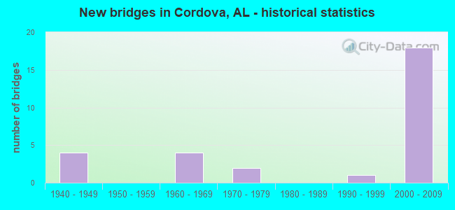
- New bridges - historical statistics
- 41940-1949
- 41960-1969
- 21970-1979
- 11990-1999
- 182000-2009


- Bridge Condition - Deck
- 13.6%Very good
- 54.5%Good
- 13.6%Satisfactory
- 18.2%Fair

- Bridge Condition - Superstructure
- 13.6%Very good
- 54.5%Good
- 13.6%Satisfactory
- 13.6%Fair
- 4.5%Poor

- Bridge Condition - Substructure
- 13.6%Very good
- 59.1%Good
- 13.6%Satisfactory
- 13.6%Fair

- Bridge Condition - Channel
- 12.5%Very good
- 37.5%Good
- 43.8%Satisfactory
- 6.3%Fair

- Bridge Condition - Culverts
- 50.0%Good
- 50.0%Satisfactory
Find on map >> Show street view
Structure Number: 2219, Location: 1.7 MI W JCT COLUMBUS BLD (Lat: 33.750850, Lng: -87.217633), Route carried "on" structure: County highway 22, Year Built: 1940, Status: Open, Structure Length: 4.79m (15.72ft), Average Daily Traffic: 850 (year 2021), Truck Traffic: 1%, Average Future Daily Traffic: 1,275 (year 2041), Features Intersected: NORFOLK SOUTHERN RR, Facility Carried by Structure: OLD PARRISH CDV RD
Minimum Vertical Clearance: 30+ m (98+ ft), Kilometerpoint: 0.010, Lanes on structure: 2, Owner: Railroad, Approaching Roadway Width: 5.9m (19.4ft), Skew: 4 degrees, Material/Design: Concrete, Design/Construction: Tee Beam, Number Of Spans In Main Unit: 1, Number Of Approach Spans: 4, Length of Maximum Span: 13.1m (43.0ft), Curb or Sidewalk Widths: Left: 0.5m (1.6ft), Right: 0.5m (1.6ft), Curb-To-Curb Width: 7.3m (24.0ft), Out-to-Out Width: 7.9m (25.9ft)
Condition: Deck: Satisfactory, Superstructure: Fair, Substructure: Fair, Operating Rating: 32.7 metric tons, Method Used To Determine Operating Rating: Field evaluation and documented engineering judgment, Inventory Rating: 21.8 metric tons, Method Used To Determine Inventory Rating: Field evaluation and documented engineering judgment, Structural Evaluation: Somewhat better than minimum adequacy, Deck Geometry: Meets minimum limits, Underclear: Somewhat better than minimum adequacy, Approach Roadway Alignment: Better than present minimum criteria, Length Of Structure Improvement: 5.80m (19.03ft), Designated Inspection Frequency: Every 24 months, Inspection Date: December 2021, Bridge Improvement Cost: $994,000, Roadway Improvement Cost: $99,000, Total Project Cost: $1,093,000 ( Estimate for 2022), Deck Structure Type: Concrete Cast-file-Place
Find on map >> Show street view
Structure Number: 222, Location: 1 MILE N CORDOVA (Lat: 33.783333, Lng: -87.200000), Route carried "on" structure: County highway , Year Built: 1940, Status: Open, Structure Length: 1.10m (3.61ft), Average Daily Traffic: 425 (year 1991), Truck Traffic: 1%, Average Future Daily Traffic: 595 (year 2032), Features Intersected: EVANS CREEK, Facility Carried by Structure: BUTTERMILK ROAD
Minimum Vertical Clearance: 30+ m (98+ ft), Kilometerpoint: 0.010, Lanes on structure: 2, Owner: County Highway Agency, Approaching Roadway Width: 5.5m (18.0ft), Material/Design: Concrete, Design/Construction: Tee Beam, Number Of Spans In Main Unit: 2, Length of Maximum Span: 5.5m (18.0ft), Curb-To-Curb Width: 6.1m (20.0ft), Out-to-Out Width: 6.7m (22.0ft)
Condition: Deck: Satisfactory, Superstructure: Good, Substructure: Good, Channel: Satisfactory, Operating Rating: 32.7 metric tons, Method Used To Determine Operating Rating: Field evaluation and documented engineering judgment, Inventory Rating: 23.6 metric tons, Method Used To Determine Inventory Rating: Field evaluation and documented engineering judgment, Structural Evaluation: Equal to present minimum criteria, Deck Geometry: High priority of corrective action, Waterway Adequacy: Equal to present desirable criteria, Approach Roadway Alignment: Equal to present desirable criteria, Length Of Structure Improvement: 1.77m (5.81ft), Designated Inspection Frequency: Every 24 months, Inspection Date: January 2022, Bridge Improvement Cost: $255,000, Roadway Improvement Cost: $26,000, Total Project Cost: $281,000 ( Estimate for 2022), Deck Structure Type: Concrete Cast-file-Place, Wearing Surface/Protective System: Wearing Surface: Gravel
Find on map >> Show street view
Structure Number: 223, Location: 2 MILES S CORDOVA (Lat: 33.750000, Lng: -87.166667), Route carried "on" structure: County highway , Year Built: 1940, Status: Open, Structure Length: 1.10m (3.61ft), Average Daily Traffic: 100 (year 1991), Average Future Daily Traffic: 140 (year 2032), Features Intersected: BURTON CREEK, Facility Carried by Structure: GRANNY HYCHE RD
Minimum Vertical Clearance: 30+ m (98+ ft), Kilometerpoint: 0.010, Lanes on structure: 2, Owner: County Highway Agency, Approaching Roadway Width: 4.9m (16.1ft), Material/Design: Concrete, Design/Construction: Tee Beam, Number Of Spans In Main Unit: 2, Length of Maximum Span: 5.5m (18.0ft), Curb-To-Curb Width: 6.1m (20.0ft), Out-to-Out Width: 6.7m (22.0ft)
Condition: Deck: Fair, Superstructure: Satisfactory, Substructure: Fair, Channel: Satisfactory, Operating Rating: 32.7 metric tons, Method Used To Determine Operating Rating: Field evaluation and documented engineering judgment, Inventory Rating: 23.6 metric tons, Method Used To Determine Inventory Rating: Field evaluation and documented engineering judgment, Structural Evaluation: Somewhat better than minimum adequacy, Deck Geometry: Somewhat better than minimum adequacy, Waterway Adequacy: Equal to present desirable criteria, Approach Roadway Alignment: Better than present minimum criteria, Length Of Structure Improvement: 1.77m (5.81ft), Designated Inspection Frequency: Every 24 months, Inspection Date: March 2020, Bridge Improvement Cost: $267,000, Roadway Improvement Cost: $27,000, Total Project Cost: $294,000 ( Estimate for 2022), Deck Structure Type: Concrete Cast-file-Place
Find on map >> Show street view
Structure Number: 2323, Location: 0.2MI W JCT COLUMBUS BLVD (Lat: 33.754100, Lng: -87.193100), Route carried "on" structure: Alternate City street 19, Year Built: 1940, Status: Open, Structure Length: 1.64m (5.38ft), Average Daily Traffic: 650 (year 2021), Truck Traffic: 2%, Average Future Daily Traffic: 750 (year 2041), Features Intersected: LITTLE FROG AGUE CREEK, Facility Carried by Structure: OLD PARRISH CDV RD
Minimum Vertical Clearance: 30+ m (98+ ft), Kilometerpoint: 1.299, Lanes on structure: 2, Owner: City or Municipal Highway Agency, Approaching Roadway Width: 5.2m (17.1ft), Material/Design: Concrete, Design/Construction: Tee Beam, Number Of Spans In Main Unit: 3, Length of Maximum Span: 5.5m (18.0ft), Curb or Sidewalk Widths: Left: 0.3m (1.0ft), Right: 0.3m (1.0ft), Curb-To-Curb Width: 6.1m (20.0ft), Out-to-Out Width: 6.8m (22.3ft)
Condition: Deck: Fair, Superstructure: Fair, Substructure: Satisfactory, Channel: Satisfactory, Operating Rating: 32.7 metric tons, Method Used To Determine Operating Rating: Field evaluation and documented engineering judgment, Inventory Rating: 23.9 metric tons, Method Used To Determine Inventory Rating: Field evaluation and documented engineering judgment, Structural Evaluation: Somewhat better than minimum adequacy, Deck Geometry: High priority of corrective action, Waterway Adequacy: Equal to present minimum criteria, Approach Roadway Alignment: Better than present minimum criteria, Length Of Structure Improvement: 2.32m (7.61ft), Designated Inspection Frequency: Every 24 months, Inspection Date: December 2021, Bridge Improvement Cost: $351,000, Roadway Improvement Cost: $35,000, Total Project Cost: $386,000 ( Estimate for 2022), Deck Structure Type: Concrete Cast-file-Place, Wearing Surface/Protective System: Wearing Surface: Bituminous
Find on map >> Show street view
Structure Number: 8643, Location: 2 MILES E HWY 269 (Lat: 33.716667, Lng: -87.233333), Route carried "on" structure: County highway , Year Built: 1965, Status: Open, Structure Length: 0.91m (2.99ft), Average Daily Traffic: 325 (year 1991), Truck Traffic: 20%, Average Future Daily Traffic: 455 (year 2032), Design Load: H 15, Features Intersected: GAP CREEK, Facility Carried by Structure: ALDRIDGE ROAD
Minimum Vertical Clearance: 30+ m (98+ ft), Kilometerpoint: 0.010, Lanes on structure: 2, Owner: County Highway Agency, Approaching Roadway Width: 4.9m (16.1ft), Material/Design: Steel, Design/Construction: Stringer/Multi-beam, Number Of Spans In Main Unit: 2, Length of Maximum Span: 4.6m (15.1ft), Curb-To-Curb Width: 6.1m (20.0ft), Out-to-Out Width: 6.1m (20.0ft)
Condition: Deck: Very good, Superstructure: Satisfactory, Substructure: Satisfactory, Channel: Satisfactory, Operating Rating: 88.9 metric tons, Method Used To Determine Operating Rating: Load Factor (LF), Inventory Rating: 57.2 metric tons, Method Used To Determine Inventory Rating: Load Factor (LF), Structural Evaluation: Equal to present minimum criteria, Deck Geometry: Meets minimum limits, Waterway Adequacy: Better than present minimum criteria, Approach Roadway Alignment: Better than present minimum criteria, Length Of Structure Improvement: 1.59m (5.22ft), Designated Inspection Frequency: Every 24 months, Inspection Date: January 2022, Bridge Improvement Cost: $217,000, Roadway Improvement Cost: $22,000, Total Project Cost: $239,000 ( Estimate for 2022), Deck Structure Type: Concrete Cast-file-Place
Find on map >> Show street view
Structure Number: 9306, Location: 1 MILE E CORDOVA (Lat: 33.750000, Lng: -87.166667), Route carried "on" structure: County highway , Year Built: 1967, Status: Open, Structure Length: 8.14m (26.71ft), Average Daily Traffic: 1,500 (year 1981), Truck Traffic: 1%, Average Future Daily Traffic: 4,000 (year 2030), Features Intersected: FRISCO RR, Facility Carried by Structure: HORSECREEK BLVD
Minimum Vertical Clearance: 30+ m (98+ ft), Kilometerpoint: 0.010, Lanes on structure: 2, Owner: County Highway Agency, Approaching Roadway Width: 7.3m (24.0ft), Material/Design: Steel continuous, Design/Construction: Stringer/Multi-beam, Number Of Spans In Main Unit: 3, Length of Maximum Span: 29.3m (96.1ft), Curb-To-Curb Width: 13.7m (44.9ft), Out-to-Out Width: 14.6m (47.9ft)
Condition: Deck: Fair, Superstructure: Good, Substructure: Good, Operating Rating: 67.5 metric tons, Method Used To Determine Operating Rating: Load Factor (LF), Inventory Rating: 40.4 metric tons, Method Used To Determine Inventory Rating: Load Factor (LF), Structural Evaluation: Better than present minimum criteria, Deck Geometry: Superior to present desirable criteria, Underclear: Superior to present desirable criteria, Approach Roadway Alignment: Equal to present desirable criteria, Length Of Structure Improvement: 9.14m (29.99ft), Designated Inspection Frequency: Every 24 months, Inspection Date: July 2021, Bridge Improvement Cost: $2,947,000, Roadway Improvement Cost: $295,000, Total Project Cost: $3,242,000 ( Estimate for 2022), Deck Structure Type: Concrete Cast-file-Place
Find on map >> Show street view
Structure Number: 9307, Location: 0.35MI E AMORY AVE/CR30 (Lat: 33.750000, Lng: -87.183333), Route carried "on" structure: County highway , Year Built: 1967, Status: Open, Structure Length: 4.19m (13.75ft), Average Daily Traffic: 1,500 (year 1991), Truck Traffic: 20%, Average Future Daily Traffic: 2,100 (year 2032), Design Load: HS 20, Features Intersected: BRANCH (RELIEF), Facility Carried by Structure: HORSE CRK BLVD
Minimum Vertical Clearance: 30+ m (98+ ft), Kilometerpoint: 0.010, Lanes on structure: 2, Owner: County Highway Agency, Approaching Roadway Width: 6.9m (22.6ft), Material/Design: Concrete, Design/Construction: Tee Beam, Number Of Spans In Main Unit: 4, Length of Maximum Span: 10.4m (34.1ft), Curb or Sidewalk Widths: Left: 0.5m (1.6ft), Right: 0.5m (1.6ft), Curb-To-Curb Width: 8.5m (27.9ft), Out-to-Out Width: 9.8m (32.2ft)
Condition: Deck: Good, Superstructure: Good, Substructure: Good, Channel: Very good, Operating Rating: 47.4 metric tons, Method Used To Determine Operating Rating: Load Factor (LF), Inventory Rating: 28.5 metric tons, Method Used To Determine Inventory Rating: Load Factor (LF), Structural Evaluation: Better than present minimum criteria, Deck Geometry: Somewhat better than minimum adequacy, Waterway Adequacy: Superior to present desirable criteria, Approach Roadway Alignment: Better than present minimum criteria, Length Of Structure Improvement: 5.16m (16.93ft), Designated Inspection Frequency: Every 24 months, Inspection Date: March 2020, Bridge Improvement Cost: $1,133,000, Roadway Improvement Cost: $113,000, Total Project Cost: $1,246,000 ( Estimate for 2022), Deck Structure Type: Concrete Cast-file-Place
Find on map >> Show street view
Structure Number: 9364, Location: 0.1MI E AMORY AVE/CR 30 (Lat: 33.756700, Lng: -87.172267), Route carried "on" structure: Alternate City street 35, Year Built: 1967, Status: Open, Structure Length: 26.44m (86.75ft), Average Daily Traffic: 4,006 (year 2021), Truck Traffic: 10%, Average Future Daily Traffic: 6,000 (year 2041), Design Load: HS 20, Features Intersected: MULBERRY FORK WARRIOR RV, Facility Carried by Structure: HORSE CRK BLVDCR30
Minimum Vertical Clearance: 30+ m (98+ ft), Kilometerpoint: 0.100, Lanes on structure: 2, Owner: City or Municipal Highway Agency, Approaching Roadway Width: 6.9m (22.6ft), Navigation Control: Yes ( Vertical Clearance: 12.8m (42.0ft), Horizontal Clearance: 61.0m (200.1ft)), Material/Design: Steel continuous, Design/Construction: Girder and Floorbeam System, Number Of Spans In Main Unit: 3, Number Of Approach Spans: 4, Length of Maximum Span: 67.1m (220.1ft), Curb or Sidewalk Widths: Left: 0.5m (1.6ft), Right: 0.5m (1.6ft), Curb-To-Curb Width: 8.5m (27.9ft), Out-to-Out Width: 8.9m (29.2ft)
Condition: Deck: Fair, Superstructure: Fair, Substructure: Satisfactory, Channel: Good, Operating Rating: 51.9 metric tons, Method Used To Determine Operating Rating: Load Factor (LF), Inventory Rating: 31.0 metric tons, Method Used To Determine Inventory Rating: Load Factor (LF), Structural Evaluation: Somewhat better than minimum adequacy, Deck Geometry: Meets minimum limits, Waterway Adequacy: Equal to present desirable criteria, Approach Roadway Alignment: Better than present minimum criteria, Length Of Structure Improvement: 26.44m (86.75ft), Designated Inspection Frequency: Every 24 months, Critical Feature Inspection Frequency: Every 24 months, Underwater Inspection Frequency: Every 48 months, Inspection Date: Febuary 2022, Critical Feature Inspection Date: Febuary 2022, Underwater Inspection Date: May 2021, Bridge Improvement Cost: $5,257,000, Roadway Improvement Cost: $526,000, Total Project Cost: $5,783,000 ( Estimate for 2022), Deck Structure Type: Concrete Cast-file-Place
Find on map >> Show street view
Structure Number: 11172, Location: DOVERTOWN (Lat: 33.740806, Lng: -87.169500), Route carried "on" structure: County highway , Year Built: 1974, Status: Posted for load, Structure Length: 6.22m (20.41ft), Average Daily Traffic: 400 (year 1995), Truck Traffic: 1%, Average Future Daily Traffic: 560 (year 2033), Design Load: H 15, Features Intersected: FRISCO RR, Facility Carried by Structure: DOVERTON ROAD
Minimum Vertical Clearance: 30+ m (98+ ft), Kilometerpoint: 0.010, Lanes on structure: 2, Owner: County Highway Agency, Approaching Roadway Width: 6.7m (22.0ft), Material/Design: Steel continuous, Design/Construction: Stringer/Multi-beam, Number Of Spans In Main Unit: 3, Length of Maximum Span: 24.4m (80.1ft), Curb-To-Curb Width: 8.5m (27.9ft), Out-to-Out Width: 9.1m (29.9ft)
Condition: Deck: Good, Superstructure: Good, Substructure: Good, Operating Rating: 45.8 metric tons, Method Used To Determine Operating Rating: Load Factor (LF), Inventory Rating: 27.5 metric tons, Method Used To Determine Inventory Rating: Load Factor (LF), Structural Evaluation: Equal to present minimum criteria, Deck Geometry: Equal to present minimum criteria, Underclear: Superior to present desirable criteria, Approach Roadway Alignment: Equal to present minimum criteria, Length Of Structure Improvement: 7.26m (23.82ft), Designated Inspection Frequency: Every 24 months, Other Special Inspection Frequency: Every 12 months, Inspection Date: January 2021, Other Special Inspection Date: January 2022, Bridge Improvement Cost: $1,493,000, Roadway Improvement Cost: $149,000, Total Project Cost: $1,642,000 ( Estimate for 2022), Deck Structure Type: Concrete Cast-file-Place
Find on map >> Show street view
Structure Number: 11967, Location: 6 MI E Jasper (Lat: 33.806258, Lng: -87.139375), Route carried "on" structure: State highway 5, Year Built: 1978, Status: Open, Structure Length: 24.63m (80.81ft), Average Daily Traffic: 11,113 (year 2020), Truck Traffic: 18%, Average Future Daily Traffic: 9,873 (year 2041), Design Load: HS 20, Features Intersected: Mulberry Fork Warrior
Minimum Vertical Clearance: 30+ m (98+ ft), Kilometerpoint: 262.719, Lanes on structure: 2, Base Highway Network: Yes, Owner: State Highway Agency, Approaching Roadway Width: 12.2m (40.0ft), Navigation Control: Yes ( Vertical Clearance: 14.9m (48.9ft), Horizontal Clearance: 74.7m (245.1ft)), Material/Design: Steel continuous, Design/Construction: Girder and Floorbeam System, Number Of Spans In Main Unit: 3, Number Of Approach Spans: 2, Length of Maximum Span: 79.2m (259.8ft), Curb-To-Curb Width: 12.2m (40.0ft), Out-to-Out Width: 13.0m (42.7ft)
Condition: Deck: Satisfactory, Superstructure: Poor, Substructure: Good, Channel: Good, Operating Rating: 36.7 metric tons, Method Used To Determine Operating Rating: Load Factor (LF), Inventory Rating: 21.9 metric tons, Method Used To Determine Inventory Rating: Load Factor (LF), Structural Evaluation: Meets minimum limits, Deck Geometry: Better than present minimum criteria, Waterway Adequacy: Superior to present desirable criteria, Approach Roadway Alignment: Equal to present desirable criteria, Length Of Structure Improvement: 24.63m (80.81ft), Designated Inspection Frequency: Every 24 months, Critical Feature Inspection Frequency: Every 24 months, Other Special Inspection Frequency: Every 12 months, Inspection Date: May 2020, Critical Feature Inspection Date: May 2020, Other Special Inspection Date: May 2021, Bridge Improvement Cost: $7,093,000, Roadway Improvement Cost: $709,000, Total Project Cost: $7,802,000 ( Estimate for 2022), Deck Structure Type: Concrete Cast-file-Place
Find on map >> Show street view
Structure Number: 15448, Location: 3.5 MI S JCT BHM HWY CR61 (Lat: 33.770150, Lng: -87.189317), Route carried "on" structure: Alternate City street 36, Year Built: 1991, Status: Posted for load, Structure Length: 4.54m (14.90ft), Average Daily Traffic: 3,000 (year 2021), Truck Traffic: 10%, Average Future Daily Traffic: 5,000 (year 2041), Features Intersected: CANE CREEK, Facility Carried by Structure: GARDNERS GIN RD
Minimum Vertical Clearance: 30+ m (98+ ft), Kilometerpoint: 0.999, Lanes on structure: 2, Owner: City or Municipal Highway Agency, Approaching Roadway Width: 7.6m (24.9ft), Material/Design: Steel, Design/Construction: Stringer/Multi-beam, Number Of Spans In Main Unit: 2, Number Of Approach Spans: 1, Length of Maximum Span: 18.3m (60.0ft), Curb-To-Curb Width: 7.3m (24.0ft), Out-to-Out Width: 8.1m (26.6ft)
Condition: Deck: Good, Superstructure: Satisfactory, Substructure: Fair, Channel: Satisfactory, Operating Rating: 34.0 metric tons, Method Used To Determine Operating Rating: Load Factor (LF), Inventory Rating: 20.4 metric tons, Method Used To Determine Inventory Rating: Load Factor (LF), Structural Evaluation: Somewhat better than minimum adequacy, Deck Geometry: High priority of replacement, Waterway Adequacy: Superior to present desirable criteria, Approach Roadway Alignment: Equal to present desirable criteria, Bridge Posting: Required (Relationship of Operating Rating to Maximum Legal Load: 10.0 - 19.9% below), Length Of Structure Improvement: 5.53m (18.14ft), Designated Inspection Frequency: Every 24 months, Underwater Inspection Frequency: Every 48 months, Other Special Inspection Frequency: Every 12 months, Inspection Date: December 2021, Underwater Inspection Date: May 2021, Other Special Inspection Date: December 2021, Bridge Improvement Cost: $986,000, Roadway Improvement Cost: $99,000, Total Project Cost: $1,085,000 ( Estimate for 2022), Deck Structure Type: Concrete Cast-file-Place
Find on map >> Show street view
Structure Number: 17685, Location: .6 MI W Reed Rd (Lat: 33.715386, Lng: -87.164447), Route carried "on" structure: Interstate 22, Year Built: 2004, Status: Open, Structure Length: 0.89m (2.92ft), Average Daily Traffic: 18,280 (year 2013), Truck Traffic: 22%, Average Future Daily Traffic: 24,766 (year 2041), Design Load: HS 20, Features Intersected: Trib to Barton Creek
Minimum Vertical Clearance: 30.18m (99.02ft), Kilometerpoint: 117.804, Lanes on structure: 6, Base Highway Network: Yes, Toll: Toll bridge is a segment, Owner: State Highway Agency, Approaching Roadway Width: 21.9m (71.9ft), Skew: 3 degrees, Material/Design: Concrete, Design/Construction: Culvert, Number Of Spans In Main Unit: 3, Length of Maximum Span: 2.4m (7.9ft), Out-to-Out Width: 304.5m (999.0ft)
Condition: Channel: Good, Culverts: Satisfactory, Operating Rating: 88.9 metric tons, Method Used To Determine Operating Rating: Load Factor (LF), Inventory Rating: 88.9 metric tons, Method Used To Determine Inventory Rating: Load Factor (LF), Structural Evaluation: Equal to present minimum criteria, Waterway Adequacy: Better than present minimum criteria, Approach Roadway Alignment: Equal to present desirable criteria, Length Of Structure Improvement: 1.56m (5.12ft), Designated Inspection Frequency: Every 24 months, Inspection Date: August 2021, Bridge Improvement Cost: $5,069,000, Roadway Improvement Cost: $507,000, Total Project Cost: $5,576,000 ( Estimate for 2022)
Find on map >> Show street view
Structure Number: 177, Location: Cordova Exit (Lat: 33.741661, Lng: -87.200686), Route carried "on" structure: Interstate 22, Year Built: 2003, Status: Open, Structure Length: 9.55m (31.33ft), Average Daily Traffic: 8,720 (year 2013), Truck Traffic: 22%, Average Future Daily Traffic: 11,814 (year 2041), Design Load: HS 20, Features Intersected: CR-20
Minimum Vertical Clearance: 30+ m (98+ ft), Kilometerpoint: 112.976, Lanes on structure: 6, Lanes under structure: 2, Base Highway Network: Yes, Owner: State Highway Agency, Approaching Roadway Width: 17.1m (56.1ft), Skew: 2 degrees, Material/Design: Prestressed concrete, Design/Construction: Stringer/Multi-beam, Number Of Spans In Main Unit: 3, Length of Maximum Span: 34.9m (114.5ft), Curb-To-Curb Width: 20.7m (67.9ft), Out-to-Out Width: 21.6m (70.9ft)
Condition: Deck: Good, Superstructure: Good, Substructure: Good, Operating Rating: 83.9 metric tons, Method Used To Determine Operating Rating: Load Factor (LF), Inventory Rating: 43.2 metric tons, Method Used To Determine Inventory Rating: Load Factor (LF), Structural Evaluation: Better than present minimum criteria, Deck Geometry: High priority of replacement, Underclear: Superior to present desirable criteria, Approach Roadway Alignment: Equal to present desirable criteria, Length Of Structure Improvement: 10.50m (34.45ft), Designated Inspection Frequency: Every 24 months, Inspection Date: November 2021, Bridge Improvement Cost: $5,039,000, Roadway Improvement Cost: $504,000, Total Project Cost: $5,543,000 ( Estimate for 2022), Deck Structure Type: Concrete Cast-file-Place
Find on map >> Show street view
Structure Number: 17701, Location: Cordova Exit (Lat: 33.741622, Lng: -87.201169), Route carried "on" structure: Interstate 22, Year Built: 2003, Status: Open, Structure Length: 9.66m (31.69ft), Average Daily Traffic: 8,720 (year 2013), Truck Traffic: 22%, Average Future Daily Traffic: 11,814 (year 2041), Design Load: HS 20, Features Intersected: CR-22
Minimum Vertical Clearance: 30+ m (98+ ft), Kilometerpoint: 112.976, Lanes on structure: 6, Lanes under structure: 2, Base Highway Network: Yes, Owner: State Highway Agency, Approaching Roadway Width: 17.1m (56.1ft), Skew: 2 degrees, Material/Design: Prestressed concrete, Design/Construction: Stringer/Multi-beam, Number Of Spans In Main Unit: 3, Length of Maximum Span: 35.3m (115.8ft), Curb-To-Curb Width: 24.4m (80.1ft), Out-to-Out Width: 25.3m (83.0ft)
Condition: Deck: Good, Superstructure: Good, Substructure: Good, Operating Rating: 84.5 metric tons, Method Used To Determine Operating Rating: Load Factor (LF), Inventory Rating: 44.7 metric tons, Method Used To Determine Inventory Rating: Load Factor (LF), Structural Evaluation: Better than present minimum criteria, Deck Geometry: Meets minimum limits, Underclear: Superior to present desirable criteria, Approach Roadway Alignment: Equal to present desirable criteria, Length Of Structure Improvement: 10.60m (34.78ft), Designated Inspection Frequency: Every 24 months, Inspection Date: November 2021, Bridge Improvement Cost: $6,034,000, Roadway Improvement Cost: $603,000, Total Project Cost: $6,637,000 ( Estimate for 2022), Deck Structure Type: Concrete Cast-file-Place
Find on map >> Show street view
Structure Number: 17726, Location: .3 MI S Cordova Exit (Lat: 33.733244, Lng: -87.195367), Route carried "on" structure: Interstate 22, Year Built: 2002, Status: Open, Structure Length: 1.00m (3.28ft), Average Daily Traffic: 17,440 (year 2013), Truck Traffic: 22%, Average Future Daily Traffic: 23,628 (year 2041), Design Load: HS 20, Features Intersected: Frog Auge Creek
Minimum Vertical Clearance: 30.18m (99.02ft), Kilometerpoint: 113.459, Lanes on structure: 6, Base Highway Network: Yes, Owner: State Highway Agency, Approaching Roadway Width: 21.9m (71.9ft), Skew: 5 degrees, Material/Design: Concrete, Design/Construction: Culvert, Number Of Spans In Main Unit: 2, Length of Maximum Span: 4.8m (15.7ft), Out-to-Out Width: 304.5m (999.0ft)
Condition: Channel: Good, Culverts: Satisfactory, Operating Rating: 88.9 metric tons, Method Used To Determine Operating Rating: Load Factor (LF), Inventory Rating: 88.9 metric tons, Method Used To Determine Inventory Rating: Load Factor (LF), Structural Evaluation: Equal to present minimum criteria, Waterway Adequacy: Better than present minimum criteria, Approach Roadway Alignment: Equal to present desirable criteria, Length Of Structure Improvement: 1.68m (5.51ft), Designated Inspection Frequency: Every 24 months, Inspection Date: August 2021, Bridge Improvement Cost: $10,013,000, Roadway Improvement Cost: $1,001,000, Total Project Cost: $11,014,000 ( Estimate for 2019)
Find on map >> Show street view
Structure Number: 17775, Location: Cordova (Lat: 33.759000, Lng: -87.205500), Route carried "on" structure: Interstate 22, Year Built: 2002, Status: Open, Structure Length: 26.27m (86.19ft), Average Daily Traffic: 9,515 (year 2017), Truck Traffic: 22%, Average Future Daily Traffic: 12,891 (year 2041), Design Load: HS 20, Features Intersected: NS Railroad
Minimum Vertical Clearance: 30+ m (98+ ft), Kilometerpoint: 110.401, Lanes on structure: 3, Base Highway Network: Yes, Owner: State Highway Agency, Approaching Roadway Width: 18.3m (60.0ft), Skew: 10 degrees, Material/Design: Steel continuous, Design/Construction: Stringer/Multi-beam, Number Of Spans In Main Unit: 4, Number Of Approach Spans: 1, Length of Maximum Span: 64.0m (210.0ft), Curb-To-Curb Width: 17.1m (56.1ft), Out-to-Out Width: 17.9m (58.7ft)
Condition: Deck: Good, Superstructure: Very good, Substructure: Good, Operating Rating: 65.9 metric tons, Method Used To Determine Operating Rating: Load Factor (LF), Inventory Rating: 41.1 metric tons, Method Used To Determine Inventory Rating: Load Factor (LF), Structural Evaluation: Better than present minimum criteria, Deck Geometry: Equal to present minimum criteria, Approach Roadway Alignment: Superior to present desirable criteria, Length Of Structure Improvement: 26.27m (86.19ft), Designated Inspection Frequency: Every 24 months, Inspection Date: January 2021, Bridge Improvement Cost: $10,449,000, Roadway Improvement Cost: $1,045,000, Total Project Cost: $11,494,000 ( Estimate for 2022), Deck Structure Type: Concrete Cast-file-Place
Find on map >> Show street view
Structure Number: 17776, Location: W of Cordova (Lat: 33.777000, Lng: -87.210400), Route carried "on" structure: Interstate 22, Year Built: 2002, Status: Open, Structure Length: 15.24m (50.00ft), Average Daily Traffic: 9,515 (year 2017), Truck Traffic: 22%, Average Future Daily Traffic: 12,891 (year 2040), Design Load: HS 20, Features Intersected: Cane Creek
Minimum Vertical Clearance: 30+ m (98+ ft), Kilometerpoint: 108.792, Lanes on structure: 3, Base Highway Network: Yes, Owner: State Highway Agency, Approaching Roadway Width: 18.3m (60.0ft), Skew: 10 degrees, Material/Design: Prestressed concrete, Design/Construction: Stringer/Multi-beam, Number Of Spans In Main Unit: 4, Length of Maximum Span: 38.1m (125.0ft), Curb-To-Curb Width: 17.1m (56.1ft), Out-to-Out Width: 17.9m (58.7ft)
Condition: Deck: Good, Superstructure: Good, Substructure: Good, Channel: Good, Operating Rating: 88.9 metric tons, Method Used To Determine Operating Rating: Load Factor (LF), Inventory Rating: 54.0 metric tons, Method Used To Determine Inventory Rating: Load Factor (LF), Structural Evaluation: Better than present minimum criteria, Deck Geometry: Equal to present minimum criteria, Waterway Adequacy: Equal to present desirable criteria, Approach Roadway Alignment: Equal to present desirable criteria, Length Of Structure Improvement: 16.01m (52.53ft), Designated Inspection Frequency: Every 24 months, Inspection Date: January 2021, Bridge Improvement Cost: $6,367,000, Roadway Improvement Cost: $637,000, Total Project Cost: $7,004,000 ( Estimate for 2022), Deck Structure Type: Concrete Cast-file-Place
Find on map >> Show street view
Structure Number: 1778, Location: WEST OF CORDOVA (Lat: 33.777194, Lng: -87.208914), Route carried "on" structure: Interstate 22, Year Built: 2002, Status: Open, Structure Length: 15.24m (50.00ft), Average Daily Traffic: 9,515 (year 2017), Truck Traffic: 22%, Average Future Daily Traffic: 12,891 (year 2040), Design Load: HS 20, Features Intersected: Cane Creek
Minimum Vertical Clearance: 30+ m (98+ ft), Kilometerpoint: 108.953, Lanes on structure: 3, Base Highway Network: Yes, Owner: State Highway Agency, Approaching Roadway Width: 18.3m (60.0ft), Skew: 10 degrees, Material/Design: Prestressed concrete, Design/Construction: Stringer/Multi-beam, Number Of Spans In Main Unit: 4, Length of Maximum Span: 38.1m (125.0ft), Curb-To-Curb Width: 17.1m (56.1ft), Out-to-Out Width: 17.9m (58.7ft)
Condition: Deck: Good, Superstructure: Good, Substructure: Very good, Channel: Good, Operating Rating: 86.1 metric tons, Method Used To Determine Operating Rating: Load Factor (LF), Inventory Rating: 39.3 metric tons, Method Used To Determine Inventory Rating: Load Factor (LF), Structural Evaluation: Better than present minimum criteria, Deck Geometry: Equal to present minimum criteria, Waterway Adequacy: Equal to present desirable criteria, Approach Roadway Alignment: Equal to present desirable criteria, Length Of Structure Improvement: 16.01m (52.53ft), Designated Inspection Frequency: Every 24 months, Inspection Date: January 2021, Bridge Improvement Cost: $6,367,000, Roadway Improvement Cost: $637,000, Total Project Cost: $7,004,000 ( Estimate for 2022), Deck Structure Type: Concrete Cast-file-Place
Find on map >> Show street view
Structure Number: 17781, Location: Cordova (Lat: 33.758900, Lng: -87.205800), Route carried "on" structure: Interstate 22, Year Built: 2002, Status: Open, Structure Length: 26.27m (86.19ft), Average Daily Traffic: 9,515 (year 2017), Truck Traffic: 22%, Average Future Daily Traffic: 12,891 (year 2041), Design Load: HS 20, Features Intersected: NS Railroad
Minimum Vertical Clearance: 30+ m (98+ ft), Kilometerpoint: 110.401, Lanes on structure: 3, Lanes under structure: 1, Base Highway Network: Yes, Owner: State Highway Agency, Approaching Roadway Width: 18.3m (60.0ft), Skew: 10 degrees, Material/Design: Steel continuous, Design/Construction: Stringer/Multi-beam, Number Of Spans In Main Unit: 4, Number Of Approach Spans: 1, Length of Maximum Span: 64.0m (210.0ft), Curb-To-Curb Width: 17.1m (56.1ft), Out-to-Out Width: 17.9m (58.7ft)
Condition: Deck: Good, Superstructure: Very good, Substructure: Very good, Operating Rating: 65.9 metric tons, Method Used To Determine Operating Rating: Load Factor (LF), Inventory Rating: 41.1 metric tons, Method Used To Determine Inventory Rating: Load Factor (LF), Structural Evaluation: Equal to present desirable criteria, Deck Geometry: Equal to present minimum criteria, Approach Roadway Alignment: Superior to present desirable criteria, Length Of Structure Improvement: 26.27m (86.19ft), Designated Inspection Frequency: Every 24 months, Inspection Date: January 2021, Bridge Improvement Cost: $10,449,000, Roadway Improvement Cost: $1,045,000, Total Project Cost: $11,494,000 ( Estimate for 2022), Deck Structure Type: Concrete Cast-file-Place
Find on map >> Show street view
Structure Number: 17786, Location: Reed Rd I-22 MP 74.3 (Lat: 33.713053, Lng: -87.154464), Route carried "on" structure: County highway , Year Built: 2004, Status: Open, Structure Length: 11.89m (39.01ft), Average Daily Traffic: 500 (year 2004), Truck Traffic: 1%, Average Future Daily Traffic: 800 (year 2041), Design Load: HS 20, Features Intersected: I-22, Facility Carried by Structure: Reed Road
Minimum Vertical Clearance: 30+ m (98+ ft), Kilometerpoint: 0.100, Lanes on structure: 2, Lanes under structure: 6, Owner: State Highway Agency, Approaching Roadway Width: 10.4m (34.1ft), Skew: 1 degrees, Material/Design: Prestressed concrete continuous, Design/Construction: Stringer/Multi-beam, Number Of Spans In Main Unit: 4, Length of Maximum Span: 36.6m (120.1ft), Curb-To-Curb Width: 10.4m (34.1ft), Out-to-Out Width: 11.2m (36.7ft)
Condition: Deck: Good, Superstructure: Good, Substructure: Good, Operating Rating: 88.9 metric tons, Method Used To Determine Operating Rating: Load Factor (LF), Inventory Rating: 57.9 metric tons, Method Used To Determine Inventory Rating: Load Factor (LF), Structural Evaluation: Better than present minimum criteria, Deck Geometry: Equal to present minimum criteria, Underclear: Better than present minimum criteria, Approach Roadway Alignment: Equal to present desirable criteria, Length Of Structure Improvement: 12.74m (41.80ft), Designated Inspection Frequency: Every 24 months, Inspection Date: August 2021, Bridge Improvement Cost: $3,146,000, Roadway Improvement Cost: $315,000, Total Project Cost: $3,461,000 ( Estimate for 2022), Deck Structure Type: Concrete Cast-file-Place
Find on map >> Show street view
Structure Number: 18172, Location: Cordova (Lat: 33.750247, Lng: -87.203500), Route carried "on" structure: County highway 22, Year Built: 2002, Status: Open, Structure Length: 13.87m (45.51ft), Average Daily Traffic: 500 (year 2004), Average Future Daily Traffic: 1,000 (year 2041), Design Load: HS 20, Features Intersected: I-22
Minimum Vertical Clearance: 30+ m (98+ ft), Kilometerpoint: 0.000, Lanes on structure: 2, Lanes under structure: 6, Owner: State Highway Agency, Approaching Roadway Width: 6.1m (20.0ft), Skew: 1 degrees, Material/Design: Prestressed concrete, Design/Construction: Stringer/Multi-beam, Number Of Spans In Main Unit: 4, Length of Maximum Span: 39.6m (129.9ft), Curb-To-Curb Width: 10.4m (34.1ft), Out-to-Out Width: 11.2m (36.7ft)
Condition: Deck: Good, Superstructure: Good, Substructure: Good, Operating Rating: 88.9 metric tons, Method Used To Determine Operating Rating: Load Factor (LF), Inventory Rating: 32.7 metric tons, Method Used To Determine Inventory Rating: Load Factor (LF), Structural Evaluation: Better than present minimum criteria, Deck Geometry: Equal to present minimum criteria, Underclear: Better than present minimum criteria, Approach Roadway Alignment: Equal to present desirable criteria, Length Of Structure Improvement: 14.67m (48.13ft), Designated Inspection Frequency: Every 24 months, Inspection Date: August 2021, Bridge Improvement Cost: $3,621,000, Roadway Improvement Cost: $362,000, Total Project Cost: $3,983,000 ( Estimate for 2022), Deck Structure Type: Concrete Cast-file-Place
Find on map >> Show street view
Structure Number: 18255, Location: .5 MI E Cane Creek (Lat: 33.773056, Lng: -87.208333), Route carried "on" structure: Interstate 22, Year Built: 2002, Status: Open, Structure Length: 0.85m (2.79ft), Average Daily Traffic: 22,592 (year 2020), Truck Traffic: 22%, Average Future Daily Traffic: 25,783 (year 2041), Design Load: HS 20, Features Intersected: Cane Creek
Minimum Vertical Clearance: 30+ m (98+ ft), Kilometerpoint: 109.918, Lanes on structure: 6, Base Highway Network: Yes, Owner: State Highway Agency, Approaching Roadway Width: 35.4m (116.1ft), Skew: 4 degrees, Material/Design: Concrete, Design/Construction: Culvert, Number Of Spans In Main Unit: 2, Length of Maximum Span: 3.0m (9.8ft)
Condition: Channel: Fair, Culverts: Good, Operating Rating: 88.9 metric tons, Method Used To Determine Operating Rating: Load Factor (LF), Inventory Rating: 88.9 metric tons, Method Used To Determine Inventory Rating: Load Factor (LF), Structural Evaluation: Better than present minimum criteria, Waterway Adequacy: Equal to present minimum criteria, Approach Roadway Alignment: Superior to present desirable criteria, Length Of Structure Improvement: 1.51m (4.95ft), Designated Inspection Frequency: Every 24 months, Inspection Date: August 2021, Bridge Improvement Cost: $7,855,000, Roadway Improvement Cost: $786,000, Total Project Cost: $8,641,000 ( Estimate for 2022)
Find on map >> Show street view
Structure Number: 18738, Location: CR-61 over I-22 (Lat: 33.718964, Lng: -87.180697), Route carried "on" structure: County highway 61, Year Built: 2004, Status: Open, Structure Length: 10.36m (33.99ft), Average Daily Traffic: 1,167 (year 2020), Truck Traffic: 10%, Average Future Daily Traffic: 1,400 (year 2041), Design Load: HS 20, Features Intersected: I-22, Facility Carried by Structure: Cordova-Gorgas Rd
Minimum Vertical Clearance: 30+ m (98+ ft), Kilometerpoint: 0.000, Lanes on structure: 2, Lanes under structure: 6, Owner: State Highway Agency, Approaching Roadway Width: 16.5m (54.1ft), Material/Design: Prestressed concrete, Design/Construction: Stringer/Multi-beam, Number Of Spans In Main Unit: 4, Length of Maximum Span: 36.6m (120.1ft), Curb-To-Curb Width: 16.5m (54.1ft), Out-to-Out Width: 17.3m (56.8ft)
Condition: Deck: Good, Superstructure: Good, Substructure: Good, Operating Rating: 72.8 metric tons, Method Used To Determine Operating Rating: Load Factor (LF), Inventory Rating: 51.7 metric tons, Method Used To Determine Inventory Rating: Load Factor (LF), Structural Evaluation: Better than present minimum criteria, Deck Geometry: Superior to present desirable criteria, Underclear: Equal to present minimum criteria, Approach Roadway Alignment: Better than present minimum criteria, Length Of Structure Improvement: 11.28m (37.01ft), Designated Inspection Frequency: Every 24 months, Inspection Date: September 2021, Bridge Improvement Cost: $4,331,000, Roadway Improvement Cost: $433,000, Total Project Cost: $4,764,000 ( Estimate for 2022), Deck Structure Type: Concrete Cast-file-Place
Find on map >> Show street view
Structure Number: 18786, Location: 1.9 MILES SOUTH OF OLD 78 (Lat: 33.783333, Lng: -87.183333), Route carried "on" structure: County highway , Year Built: 2003, Status: Open, Structure Length: 1.10m (3.61ft), Average Daily Traffic: 110 (year 2003), Average Future Daily Traffic: 250 (year 2033), Features Intersected: OLD KIRKPATRICK RD, Facility Carried by Structure: TRIB OF WATTS CRK
Minimum Vertical Clearance: 30+ m (98+ ft), Kilometerpoint: 0.000, Lanes on structure: 2, Owner: County Highway Agency, Approaching Roadway Width: 6.1m (20.0ft), Material/Design: Steel, Design/Construction: Stringer/Multi-beam, Number Of Spans In Main Unit: 2, Length of Maximum Span: 5.5m (18.0ft), Curb-To-Curb Width: 6.1m (20.0ft), Out-to-Out Width: 6.1m (20.0ft)
Condition: Deck: Very good, Superstructure: Good, Substructure: Good, Channel: Satisfactory, Operating Rating: 88.9 metric tons, Method Used To Determine Operating Rating: Load Factor (LF), Inventory Rating: 88.9 metric tons, Method Used To Determine Inventory Rating: Load Factor (LF), Structural Evaluation: Better than present minimum criteria, Deck Geometry: Meets minimum limits, Waterway Adequacy: Equal to present desirable criteria, Approach Roadway Alignment: Equal to present minimum criteria, Length Of Structure Improvement: 1.77m (5.81ft), Designated Inspection Frequency: Every 24 months, Inspection Date: October 2021, Bridge Improvement Cost: $243,000, Roadway Improvement Cost: $24,000, Total Project Cost: $267,000 ( Estimate for 2022), Deck Structure Type: Concrete Cast-file-Place
Find on map >> Show street view
Structure Number: 19004, Location: 0.3 MI N CRE HTS RD/CR61 (Lat: 33.777317, Lng: -87.190667), Route carried "on" structure: City street , Year Built: 2003, Status: Open, Structure Length: 0.62m (2.03ft), Average Daily Traffic: 100 (year 2021), Average Future Daily Traffic: 150 (year 2041), Design Load: HS 20, Features Intersected: EVANS CREEK, Facility Carried by Structure: CRESTVIEW HTS RD
Minimum Vertical Clearance: 30+ m (98+ ft), Kilometerpoint: 0.000, Lanes on structure: 2, Toll: Toll bridge is a segment, Owner: City or Municipal Highway Agency, Approaching Roadway Width: 5.4m (17.7ft), Material/Design: Concrete, Design/Construction: Culvert, Number Of Spans In Main Unit: 2, Length of Maximum Span: 3.0m (9.8ft)
Condition: Channel: Satisfactory, Culverts: Good, Operating Rating: 87.1 metric tons, Method Used To Determine Operating Rating: Load Factor (LF), Inventory Rating: 51.7 metric tons, Method Used To Determine Inventory Rating: Load Factor (LF), Structural Evaluation: Better than present minimum criteria, Waterway Adequacy: Equal to present desirable criteria, Approach Roadway Alignment: Better than present minimum criteria, Length Of Structure Improvement: 1.24m (4.07ft), Designated Inspection Frequency: Every 24 months, Inspection Date: December 2021, Bridge Improvement Cost: $172,000, Roadway Improvement Cost: $17,000, Total Project Cost: $189,000 ( Estimate for 2022)
Find on map >> Show street view
Structure Number: 2011, Location: 4 MILES SOUTH OF 78 HWY (Lat: 33.760931, Lng: -87.168833), Route carried "on" structure: Alternate City street 20, Year Built: 2009, Status: Open, Structure Length: 9.14m (29.99ft), Average Daily Traffic: 1,400 (year 2008), Average Future Daily Traffic: 1,850 (year 2031), Design Load: HS 20, Features Intersected: CANE CREEK, Facility Carried by Structure: RIVER ROAD
Minimum Vertical Clearance: 30+ m (98+ ft), Kilometerpoint: 0.100, Lanes on structure: 2, Owner: County Highway Agency, Approaching Roadway Width: 8.5m (27.9ft), Material/Design: Steel continuous, Design/Construction: Stringer/Multi-beam, Number Of Spans In Main Unit: 4, Length of Maximum Span: 30.5m (100.1ft), Curb-To-Curb Width: 8.5m (27.9ft), Out-to-Out Width: 9.4m (30.8ft)
Condition: Deck: Very good, Superstructure: Very good, Substructure: Very good, Channel: Very good, Operating Rating: 69.3 metric tons, Method Used To Determine Operating Rating: Load Factor (LF), Inventory Rating: 41.5 metric tons, Method Used To Determine Inventory Rating: Load Factor (LF), Structural Evaluation: Equal to present desirable criteria, Deck Geometry: Somewhat better than minimum adequacy, Waterway Adequacy: Superior to present desirable criteria, Approach Roadway Alignment: Better than present minimum criteria, Length Of Structure Improvement: 10.11m (33.17ft), Designated Inspection Frequency: Every 24 months, Inspection Date: December 2021, Bridge Improvement Cost: $2,080,000, Roadway Improvement Cost: $208,000, Total Project Cost: $2,288,000 ( Estimate for 2022), Deck Structure Type: Concrete Cast-file-Place
Find on map >> Show street view
Structure Number: 17786, Location: Reed Rd I-22 MP 74.3 (Lat: 33.713053, Lng: -87.154464), Route carried "under" structure: Interstate 22, Year Built: 2004, Structure Length: 0. m, Average Daily Traffic: 9,140 (year 2013), Truck Traffic: 22%, Features Intersected: I-22, Facility Carried by Structure: Reed Road
Minimum Vertical Clearance: 6.28m (20.60ft), Kilometerpoint: 119.574, Lanes on structure: 2, Lanes under structure: 6, Material/Design: Prestressed concrete continuous, Design/Construction: Stringer/Multi-beam, Length of Maximum Span: 36.6m (120.1ft)
Find on map >> Show street view
Structure Number: 18172, Location: Cordova (Lat: 33.750247, Lng: -87.203500), Route carried "under" structure: Interstate 22, Year Built: 2002, Structure Length: 0. m, Average Daily Traffic: 19,030 (year 2013), Truck Traffic: 22%, Features Intersected: I-22
Minimum Vertical Clearance: 30.18m (99.02ft), Kilometerpoint: 112.010, Lanes on structure: 2, Lanes under structure: 6, Material/Design: Prestressed concrete, Design/Construction: Stringer/Multi-beam, Length of Maximum Span: 39.6m (129.9ft)
Find on map >> Show street view
Structure Number: 18738, Location: CR-61 over I-22 (Lat: 33.718964, Lng: -87.180697), Route carried "under" structure: Interstate 22, Year Built: 2004, Structure Length: 0. m, Average Daily Traffic: 18,280 (year 2013), Truck Traffic: 22%, Features Intersected: I-22, Facility Carried by Structure: Cordova-Gorgas Rd
Minimum Vertical Clearance: 6.30m (20.67ft), Kilometerpoint: 116.195, Lanes on structure: 2, Lanes under structure: 6, Material/Design: Prestressed concrete, Design/Construction: Stringer/Multi-beam, Length of Maximum Span: 36.6m (120.1ft)