Bridge Statistics for Corning, Iowa (IA)
Condition, Traffic, Stress, Structural Evaluation, Project Costs
- National Bridge Inventory (NBI) Statistics
- 28Number of bridges
- 315ft / 95.7mTotal length
- 10,925Total average daily traffic
- 1,157Total average daily truck traffic
- 10,925Total future (year 2040) average daily traffic
- National Bridge Inventory (NBI) Registered Bridges for Corning
- No street view available for this location
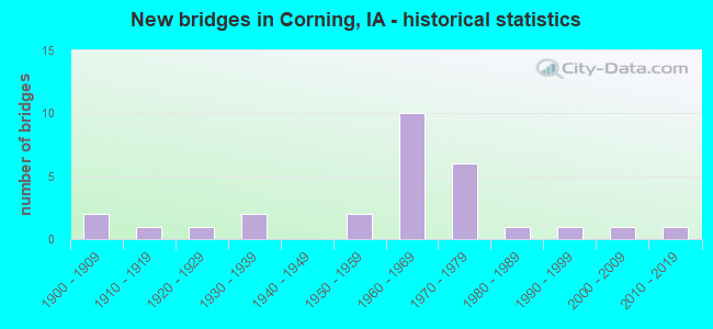
- New bridges - historical statistics
- 21900-1909
- 11910-1919
- 11920-1929
- 21930-1939
- 21950-1959
- 101960-1969
- 61970-1979
- 11980-1989
- 11990-1999
- 12000-2009
- 12010-2019

- Reconstructed bridges - Historical Statistics
- 11950-1959
- 01960-1969
- 11970-1979


- Bridge Condition - Deck
- 7.4%Very good
- 37.0%Satisfactory
- 33.3%Fair
- 14.8%Poor
- 7.4%Failed

- Bridge Condition - Superstructure
- 14.8%Very good
- 7.4%Good
- 25.9%Satisfactory
- 29.6%Fair
- 14.8%Poor
- 7.4%Failed

- Bridge Condition - Substructure
- 11.1%Very good
- 11.1%Good
- 11.1%Satisfactory
- 44.4%Fair
- 14.8%Poor
- 7.4%Failed

- Bridge Condition - Channel
- 3.6%Very good
- 3.6%Good
- 28.6%Satisfactory
- 57.1%Fair
- 3.6%Poor
- 3.6%Serious
Find on map >> Show street view
Structure Number: 2611, Location: 071340300 (Lat: 40.982908, Lng: -94.740822), Route carried "on" structure: City street , Year Built: 2012, Status: Open, Structure Length: 5.97m (19.59ft), Average Daily Traffic: 870 (year 2016), Average Future Daily Traffic: 870 (year 2040), Design Load: HL 93, Features Intersected: EAST NODAWAY RIVER, Facility Carried by Structure: LOOMIS ST
Minimum Vertical Clearance: 30+ m (98+ ft), Kilometerpoint: 0.319, Lanes on structure: 2, Owner: City or Municipal Highway Agency, Approaching Roadway Width: 9.4m (30.8ft), Skew: 3 degrees, Material/Design: Prestressed concrete, Design/Construction: Stringer/Multi-beam, Number Of Spans In Main Unit: 3, Length of Maximum Span: 21.0m (68.9ft), Curb or Sidewalk Widths: Left: 1.5m (4.9ft), Right: 0.0m, Curb-To-Curb Width: 9.1m (29.9ft), Out-to-Out Width: 11.8m (38.7ft)
Condition: Deck: Very good, Superstructure: Very good, Substructure: Very good, Channel: Very good, Operating Rating: 69.9 metric tons, Method Used To Determine Operating Rating: Load Factor (LF), Inventory Rating: 41.9 metric tons, Method Used To Determine Inventory Rating: Load Factor (LF), Structural Evaluation: Equal to present desirable criteria, Deck Geometry: Equal to present minimum criteria, Waterway Adequacy: Equal to present desirable criteria, Approach Roadway Alignment: Equal to present desirable criteria, Designated Inspection Frequency: Every 48 months, Inspection Date: December 2020, Deck Structure Type: Concrete Cast-file-Place, Wearing Surface/Protective System: Wearing Surface: Monolithic Concrete, Deck Protection: Epoxy Coated Reinforcing
Find on map >> Show street view
Structure Number: 619, Location: 087402306 (Lat: 42.337308, Lng: -95.471319), Route carried "on" structure: City street , Year Built: 1968, Status: Open, Structure Length: 2.35m (7.71ft), Average Daily Traffic: 1,090 (year 2019), Average Future Daily Traffic: 1,090 (year 2042), Design Load: H 15, Features Intersected: BADGER CREEK, Facility Carried by Structure: MAIN ST
Minimum Vertical Clearance: 30+ m (98+ ft), Kilometerpoint: 0.744, Lanes on structure: 2, Owner: City or Municipal Highway Agency, Approaching Roadway Width: 7.3m (24.0ft), Skew: 3 degrees, Material/Design: Concrete continuous, Design/Construction: Slab, Number Of Spans In Main Unit: 3, Length of Maximum Span: 8.8m (28.9ft), Curb or Sidewalk Widths: Left: 1.2m (3.9ft), Right: 1.2m (3.9ft), Curb-To-Curb Width: 7.3m (24.0ft), Out-to-Out Width: 9.8m (32.2ft)
Condition: Deck: Poor, Superstructure: Poor, Substructure: Fair, Channel: Fair, Operating Rating: 37.1 metric tons, Method Used To Determine Operating Rating: Load Factor (LF), Inventory Rating: 22.2 metric tons, Method Used To Determine Inventory Rating: Load Factor (LF), Structural Evaluation: Meets minimum limits, Deck Geometry: Meets minimum limits, Waterway Adequacy: Equal to present minimum criteria, Approach Roadway Alignment: Better than present minimum criteria, Length Of Structure Improvement: 10.30m (33.79ft), Designated Inspection Frequency: Every 24 months, Inspection Date: Febuary 2022, Bridge Improvement Cost: $15,000, Roadway Improvement Cost: $2,000, Deck Structure Type: Concrete Cast-file-Place, Wearing Surface/Protective System: Wearing Surface: Monolithic Concrete
Find on map >> Show street view
Structure Number: 1332, Location: 0.8 MI. W OF JCT.148 (Lat: 40.979464, Lng: -94.750194), Route carried "on" structure: US 34, Year Built: 1964, Status: Open, Structure Length: 25.33m (83.10ft), Average Daily Traffic: 2,680 (year 2020), Truck Traffic: 21%, Average Future Daily Traffic: 2,680 (year 2041), Design Load: HS 20, Features Intersected: E NODAWAY RIVER & RR
Minimum Vertical Clearance: 30+ m (98+ ft), Kilometerpoint: 98.328, Lanes on structure: 2, Base Highway Network: Yes, Owner: State Highway Agency, Approaching Roadway Width: 13.4m (44.0ft), Skew: 4 degrees, Material/Design: Steel continuous, Design/Construction: Stringer/Multi-beam, Number Of Spans In Main Unit: 6, Length of Maximum Span: 45.1m (148.0ft), Curb-To-Curb Width: 9.1m (29.9ft), Out-to-Out Width: 11.0m (36.1ft)
Condition: Deck: Fair, Superstructure: Good, Substructure: Fair, Channel: Fair, Operating Rating: 43.9 metric tons, Method Used To Determine Operating Rating: Load Factor (LF), Inventory Rating: 16.8 metric tons, Method Used To Determine Inventory Rating: Load Factor (LF), Structural Evaluation: Meets minimum limits, Deck Geometry: Meets minimum limits, Underclear: Better than present minimum criteria, Waterway Adequacy: Equal to present desirable criteria, Approach Roadway Alignment: Equal to present minimum criteria, Designated Inspection Frequency: Every 24 months, Inspection Date: April 2021, Deck Structure Type: Concrete Cast-file-Place, Wearing Surface/Protective System: Wearing Surface: Low Slump Concrete
Find on map >> Show street view
Structure Number: 1338, Location: 2.2 MI. S OF JCT. U.S. 34 (Lat: 40.948317, Lng: -94.738331), Route carried "on" structure: State highway 148, Year Built: 1961, Status: Open, Structure Length: 1.52m (4.99ft), Average Daily Traffic: 1,080 (year 2020), Truck Traffic: 19%, Average Future Daily Traffic: 1,080 (year 2040), Design Load: HS 20, Features Intersected: STREAM
Minimum Vertical Clearance: 30+ m (98+ ft), Kilometerpoint: 44.704, Lanes on structure: 2, Base Highway Network: Yes, Owner: State Highway Agency, Approaching Roadway Width: 12.8m (42.0ft), Material/Design: Concrete continuous, Design/Construction: Culvert, Number Of Spans In Main Unit: 3, Length of Maximum Span: 5.5m (18.0ft)
Condition: Channel: Satisfactory, Culverts: Satisfactory, Operating Rating: 43.5 metric tons, Method Used To Determine Operating Rating: Assigned rating based on Load Factor Design (LFD) reported in metric tons, Inventory Rating: 32.7 metric tons, Method Used To Determine Inventory Rating: Assigned rating based on Load Factor Design (LFD) reported in metric tons, Structural Evaluation: Equal to present minimum criteria, Waterway Adequacy: Equal to present minimum criteria, Approach Roadway Alignment: Equal to present desirable criteria, Designated Inspection Frequency: Every 24 months, Inspection Date: July 2020
Find on map >> Show street view
Structure Number: 13391, Location: 0.4 mi. N of US 34 (Lat: 40.983964, Lng: -94.731903), Route carried "on" structure: State highway 148, Year Built: 1976, Status: Open, Structure Length: 6.49m (21.29ft), Average Daily Traffic: 3,250 (year 2020), Truck Traffic: 12%, Average Future Daily Traffic: 3,250 (year 2040), Design Load: HS 20, Features Intersected: EAST NODAWAY RIVER
Minimum Vertical Clearance: 30+ m (98+ ft), Kilometerpoint: 48.776, Lanes on structure: 2, Base Highway Network: Yes, Owner: State Highway Agency, Approaching Roadway Width: 9.1m (29.9ft), Skew: 1 degrees, Material/Design: Prestressed concrete, Design/Construction: Stringer/Multi-beam, Number Of Spans In Main Unit: 3, Length of Maximum Span: 24.7m (81.0ft), Curb or Sidewalk Widths: Left: 1.6m (5.2ft), Right: 0.2m (0.7ft), Curb-To-Curb Width: 9.8m (32.2ft), Out-to-Out Width: 12.5m (41.0ft)
Condition: Deck: Satisfactory, Superstructure: Very good, Substructure: Very good, Channel: Fair, Operating Rating: 66.8 metric tons, Method Used To Determine Operating Rating: Load Factor (LF), Inventory Rating: 24.6 metric tons, Method Used To Determine Inventory Rating: Load Factor (LF), Structural Evaluation: Equal to present minimum criteria, Deck Geometry: Meets minimum limits, Waterway Adequacy: Equal to present desirable criteria, Approach Roadway Alignment: Equal to present minimum criteria, Designated Inspection Frequency: Every 24 months, Inspection Date: May 2020, Deck Structure Type: Concrete Cast-file-Place, Wearing Surface/Protective System: Wearing Surface: Low Slump Concrete
Find on map >> Show street view
Structure Number: 59045, Location: 071340203 (Lat: 40.986383, Lng: -94.728911), Route carried "on" structure: City street , Year Built: 1930, Status: Posted for load, Structure Length: 4.85m (15.91ft), Average Daily Traffic: 35 (year 2016), Average Future Daily Traffic: 35 (year 2042), Features Intersected: EAST NODAWAY RIVER, Facility Carried by Structure: 220TH STREET
Minimum Vertical Clearance: 3.33m (10.93ft), Kilometerpoint: 0.863, Lanes on structure: 1, Owner: County Highway Agency, Approaching Roadway Width: 8.5m (27.9ft), Material/Design: Steel, Design/Construction: Truss - Thru, Number Of Spans In Main Unit: 1, Length of Maximum Span: 48.2m (158.1ft), Curb-To-Curb Width: 4.8m (15.7ft), Out-to-Out Width: 5.2m (17.1ft)
Condition: Deck: Fair, Superstructure: Poor, Substructure: Fair, Channel: Fair, Operating Rating: 11.4 metric tons, Method Used To Determine Operating Rating: Allowable Stress (AS), Inventory Rating: 7.8 metric tons, Method Used To Determine Inventory Rating: Allowable Stress (AS), Structural Evaluation: High priority of replacement, Deck Geometry: High priority of replacement, Waterway Adequacy: Equal to present minimum criteria, Approach Roadway Alignment: Equal to present minimum criteria, Bridge Posting: Required (Relationship of Operating Rating to Maximum Legal Load: > 39.9% below), Length Of Structure Improvement: 19.00m (62.34ft), Designated Inspection Frequency: Every 24 months, Critical Feature Inspection Frequency: Every 24 months, Inspection Date: January 2022, Critical Feature Inspection Date: August 2020, Bridge Improvement Cost: $251,000, Roadway Improvement Cost: $25,000, Deck Structure Type: Wood or Timber, Wearing Surface/Protective System: Wearing Surface: Wood or Timber
Find on map >> Show street view
Structure Number: 59071, Location: 071340734 (Lat: 40.959133, Lng: -94.803561), Route carried "on" structure: County highway , Year Built: 1996, Status: Open, Structure Length: 5.85m (19.19ft), Average Daily Traffic: 50 (year 2016), Average Future Daily Traffic: 50 (year 2042), Design Load: HS 20, Features Intersected: EAST NODAWAY RIVER, Facility Carried by Structure: GROVE AVENUE
Minimum Vertical Clearance: 30+ m (98+ ft), Kilometerpoint: 4.456, Lanes on structure: 2, Owner: County Highway Agency, Approaching Roadway Width: 9.1m (29.9ft), Material/Design: Prestressed concrete, Design/Construction: Stringer/Multi-beam, Number Of Spans In Main Unit: 3, Length of Maximum Span: 20.7m (67.9ft), Curb-To-Curb Width: 7.5m (24.6ft), Out-to-Out Width: 8.3m (27.2ft)
Condition: Deck: Satisfactory, Superstructure: Very good, Substructure: Good, Channel: Satisfactory, Operating Rating: 75.1 metric tons, Method Used To Determine Operating Rating: Load Factor (LF), Inventory Rating: 36.6 metric tons, Method Used To Determine Inventory Rating: Load Factor (LF), Structural Evaluation: Better than present minimum criteria, Deck Geometry: Equal to present minimum criteria, Waterway Adequacy: Equal to present minimum criteria, Approach Roadway Alignment: Equal to present desirable criteria, Designated Inspection Frequency: Every 48 months, Inspection Date: January 2022, Deck Structure Type: Concrete Cast-file-Place, Wearing Surface/Protective System: Wearing Surface: Monolithic Concrete
Find on map >> Show street view
Structure Number: 59091, Location: 071341301 (Lat: 40.957694, Lng: -94.712481), Route carried "on" structure: County highway , Year Built: 1974, Status: Posted for load, Structure Length: 0.94m (3.08ft), Average Daily Traffic: 35 (year 2016), Average Future Daily Traffic: 35 (year 2042), Design Load: HS 20, Features Intersected: WEST FORK 102 RIVER, Facility Carried by Structure: 240TH STREET
Minimum Vertical Clearance: 30+ m (98+ ft), Kilometerpoint: 8.324, Lanes on structure: 2, Owner: County Highway Agency, Approaching Roadway Width: 7.6m (24.9ft), Material/Design: Concrete, Design/Construction: Channel Beam, Number Of Spans In Main Unit: 1, Length of Maximum Span: 9.1m (29.9ft), Curb-To-Curb Width: 6.0m (19.7ft), Out-to-Out Width: 6.1m (20.0ft)
Condition: Deck: Fair, Superstructure: Fair, Substructure: Satisfactory, Channel: Fair, Operating Rating: 19.4 metric tons, Method Used To Determine Operating Rating: Allowable Stress (AS), Inventory Rating: 11.9 metric tons, Method Used To Determine Inventory Rating: Allowable Stress (AS), Structural Evaluation: Meets minimum limits, Deck Geometry: Meets minimum limits, Waterway Adequacy: Equal to present minimum criteria, Approach Roadway Alignment: Equal to present minimum criteria, Bridge Posting: Required (Relationship of Operating Rating to Maximum Legal Load: 20.0 - 29.9% below), Length Of Structure Improvement: 5.50m (18.04ft), Designated Inspection Frequency: Every 24 months, Inspection Date: January 2022, Bridge Improvement Cost: $72,000, Roadway Improvement Cost: $8,000, Deck Structure Type: Other
Find on map >> Show street view
Structure Number: 591, Location: 071341302 (Lat: 40.953183, Lng: -94.719372), Route carried "on" structure: County highway , Year Built: 1967, Status: Open, Structure Length: 1.16m (3.81ft), Average Daily Traffic: 35 (year 2016), Average Future Daily Traffic: 35 (year 2042), Design Load: HS 20, Features Intersected: WEST FORK 102 RIVER, Facility Carried by Structure: KENTUCKY AVENUE
Minimum Vertical Clearance: 30+ m (98+ ft), Kilometerpoint: 5.908, Lanes on structure: 2, Owner: County Highway Agency, Approaching Roadway Width: 7.6m (24.9ft), Material/Design: Prestressed concrete, Design/Construction: Tee Beam, Number Of Spans In Main Unit: 1, Length of Maximum Span: 11.6m (38.1ft), Curb-To-Curb Width: 6.1m (20.0ft), Out-to-Out Width: 6.1m (20.0ft)
Condition: Deck: Satisfactory, Superstructure: Satisfactory, Substructure: Poor, Channel: Satisfactory, Operating Rating: 44.0 metric tons, Method Used To Determine Operating Rating: Load Factor (LF), Inventory Rating: 26.4 metric tons, Method Used To Determine Inventory Rating: Load Factor (LF), Structural Evaluation: Meets minimum limits, Deck Geometry: Somewhat better than minimum adequacy, Waterway Adequacy: Equal to present minimum criteria, Approach Roadway Alignment: Equal to present minimum criteria, Length Of Structure Improvement: 6.00m (19.69ft), Designated Inspection Frequency: Every 24 months, Inspection Date: January 2022, Bridge Improvement Cost: $79,000, Roadway Improvement Cost: $8,000, Deck Structure Type: Other
Find on map >> Show street view
Structure Number: 5912, Location: 071342103 (Lat: 40.943653, Lng: -94.761528), Route carried "on" structure: County highway , Year Built: 1969, Status: Open, Structure Length: 1.22m (4.00ft), Average Daily Traffic: 110 (year 2016), Average Future Daily Traffic: 110 (year 2042), Design Load: HS 20, Features Intersected: WEST FORK 102 RIVER, Facility Carried by Structure: 250TH STREET
Minimum Vertical Clearance: 30+ m (98+ ft), Kilometerpoint: 6.103, Lanes on structure: 2, Owner: County Highway Agency, Approaching Roadway Width: 8.2m (26.9ft), Material/Design: Prestressed concrete, Design/Construction: Tee Beam, Number Of Spans In Main Unit: 1, Length of Maximum Span: 11.9m (39.0ft), Curb-To-Curb Width: 6.0m (19.7ft), Out-to-Out Width: 6.1m (20.0ft)
Condition: Deck: Satisfactory, Superstructure: Satisfactory, Substructure: Poor, Channel: Fair, Operating Rating: 44.0 metric tons, Method Used To Determine Operating Rating: Load Factor (LF), Inventory Rating: 26.4 metric tons, Method Used To Determine Inventory Rating: Load Factor (LF), Structural Evaluation: Meets minimum limits, Deck Geometry: High priority of corrective action, Waterway Adequacy: Somewhat better than minimum adequacy, Approach Roadway Alignment: Equal to present minimum criteria, Length Of Structure Improvement: 6.00m (19.69ft), Designated Inspection Frequency: Every 24 months, Inspection Date: January 2022, Bridge Improvement Cost: $79,000, Roadway Improvement Cost: $8,000, Deck Structure Type: Other
Find on map >> Show street view
Structure Number: 5913, Location: 071342104 (Lat: 40.934258, Lng: -94.776311), Route carried "on" structure: County highway , Year Built: 1958, Status: Posted for load, Structure Length: 2.83m (9.28ft), Average Daily Traffic: 5 (year 2016), Average Future Daily Traffic: 5 (year 2042), Design Load: HS 20, Features Intersected: WEST FORK 102 RIVER, Facility Carried by Structure: HOLLY AVENUE
Minimum Vertical Clearance: 30+ m (98+ ft), Kilometerpoint: 3.745, Lanes on structure: 2, Owner: County Highway Agency, Approaching Roadway Width: 7.0m (23.0ft), Material/Design: Concrete, Design/Construction: Channel Beam, Number Of Spans In Main Unit: 3, Length of Maximum Span: 9.1m (29.9ft), Curb-To-Curb Width: 5.9m (19.4ft), Out-to-Out Width: 6.0m (19.7ft)
Condition: Deck: Poor, Superstructure: Poor, Substructure: Fair, Channel: Fair, Operating Rating: 19.4 metric tons, Method Used To Determine Operating Rating: Allowable Stress (AS), Inventory Rating: 11.9 metric tons, Method Used To Determine Inventory Rating: Allowable Stress (AS), Structural Evaluation: Meets minimum limits, Deck Geometry: Meets minimum limits, Waterway Adequacy: Equal to present desirable criteria, Approach Roadway Alignment: Equal to present minimum criteria, Bridge Posting: Required (Relationship of Operating Rating to Maximum Legal Load: 20.0 - 29.9% below), Length Of Structure Improvement: 12.00m (39.37ft), Designated Inspection Frequency: Every 24 months, Inspection Date: January 2022, Bridge Improvement Cost: $159,000, Roadway Improvement Cost: $16,000, Deck Structure Type: Other
Find on map >> Show street view
Structure Number: 59141, Location: 071342202 (Lat: 40.935514, Lng: -94.757319), Route carried "on" structure: County highway , Year Built: 1979, Status: Open, Structure Length: 0.73m (2.40ft), Average Daily Traffic: 15 (year 2016), Average Future Daily Traffic: 15 (year 2042), Design Load: H 15, Features Intersected: STREAM, Facility Carried by Structure: IRONWOOD AVENUE
Minimum Vertical Clearance: 30+ m (98+ ft), Kilometerpoint: 0.697, Lanes on structure: 2, Owner: County Highway Agency, Approaching Roadway Width: 8.2m (26.9ft), Material/Design: Prestressed concrete, Design/Construction: Tee Beam, Number Of Spans In Main Unit: 1, Length of Maximum Span: 7.0m (23.0ft), Curb-To-Curb Width: 7.6m (24.9ft), Out-to-Out Width: 7.6m (24.9ft)
Condition: Deck: Fair, Superstructure: Fair, Substructure: Satisfactory, Channel: Fair, Operating Rating: 24.5 metric tons, Method Used To Determine Operating Rating: Field evaluation and documented engineering judgment, Inventory Rating: 17.2 metric tons, Method Used To Determine Inventory Rating: Field evaluation and documented engineering judgment, Structural Evaluation: Somewhat better than minimum adequacy, Deck Geometry: Equal to present minimum criteria, Waterway Adequacy: Somewhat better than minimum adequacy, Approach Roadway Alignment: Equal to present minimum criteria, Length Of Structure Improvement: 4.00m (13.12ft), Designated Inspection Frequency: Every 24 months, Inspection Date: January 2022, Bridge Improvement Cost: $53,000, Roadway Improvement Cost: $4,000, Deck Structure Type: Other
Find on map >> Show street view
Structure Number: 5979, Location: 072331907 (Lat: 41.017131, Lng: -94.690375), Route carried "on" structure: County highway , Year Built: 1958, Status: Posted for load, Structure Length: 0.85m (2.79ft), Average Daily Traffic: 15 (year 2016), Average Future Daily Traffic: 15 (year 2040), Design Load: H 15, Features Intersected: STREAM, Facility Carried by Structure: 200TH STREET
Minimum Vertical Clearance: 30+ m (98+ ft), Kilometerpoint: 8.713, Lanes on structure: 2, Owner: County Highway Agency, Approaching Roadway Width: 7.3m (24.0ft), Material/Design: Concrete, Design/Construction: Channel Beam, Number Of Spans In Main Unit: 1, Length of Maximum Span: 7.9m (25.9ft), Curb-To-Curb Width: 5.8m (19.0ft), Out-to-Out Width: 6.0m (19.7ft)
Condition: Deck: Fair, Superstructure: Fair, Substructure: Fair, Channel: Fair, Operating Rating: 30.7 metric tons, Method Used To Determine Operating Rating: Allowable Stress (AS), Inventory Rating: 20.0 metric tons, Method Used To Determine Inventory Rating: Allowable Stress (AS), Structural Evaluation: Somewhat better than minimum adequacy, Deck Geometry: Meets minimum limits, Waterway Adequacy: Meets minimum limits, Approach Roadway Alignment: Equal to present minimum criteria, Bridge Posting: Required (Relationship of Operating Rating to Maximum Legal Load: 0.1 - 9.9% below), Length Of Structure Improvement: 4.60m (15.09ft), Designated Inspection Frequency: Every 24 months, Inspection Date: December 2020, Bridge Improvement Cost: $61,000, Roadway Improvement Cost: $6,000, Deck Structure Type: Other
Find on map >> Show street view
Structure Number: 598, Location: 072331912 (Lat: 41.016089, Lng: -94.689336), Route carried "on" structure: County highway , Year Built: 1962, Status: Posted for load, Structure Length: 0.98m (3.22ft), Average Daily Traffic: 5 (year 2016), Average Future Daily Traffic: 5 (year 2040), Design Load: HS 20, Features Intersected: STREAM, Facility Carried by Structure: MULBERRY AVE
Minimum Vertical Clearance: 30+ m (98+ ft), Kilometerpoint: 13.443, Lanes on structure: 2, Owner: County Highway Agency, Approaching Roadway Width: 9.4m (30.8ft), Material/Design: Concrete, Design/Construction: Channel Beam, Number Of Spans In Main Unit: 1, Length of Maximum Span: 9.1m (29.9ft), Curb-To-Curb Width: 5.8m (19.0ft), Out-to-Out Width: 5.9m (19.4ft)
Condition: Deck: Fair, Superstructure: Fair, Substructure: Fair, Channel: Poor, Operating Rating: 19.4 metric tons, Method Used To Determine Operating Rating: Allowable Stress (AS), Inventory Rating: 11.9 metric tons, Method Used To Determine Inventory Rating: Allowable Stress (AS), Structural Evaluation: Meets minimum limits, Deck Geometry: Meets minimum limits, Waterway Adequacy: Meets minimum limits, Approach Roadway Alignment: Better than present minimum criteria, Bridge Posting: Required (Relationship of Operating Rating to Maximum Legal Load: 20.0 - 29.9% below), Length Of Structure Improvement: 5.00m (16.40ft), Designated Inspection Frequency: Every 24 months, Inspection Date: December 2020, Bridge Improvement Cost: $69,000, Roadway Improvement Cost: $6,000, Deck Structure Type: Other, Wearing Surface/Protective System: Wearing Surface: Other
Find on map >> Show street view
Structure Number: 599, Location: 072333004 (Lat: 41.010347, Lng: -94.689367), Route carried "on" structure: County highway , Year Built: 1900, Status: Closed, Structure Length: 2.44m (8.01ft), Average Daily Traffic: 5 (year 2016), Average Future Daily Traffic: 5 (year 2040), Features Intersected: EAST NODAWAY RIVER, Facility Carried by Structure: MULBERRY AVE
Minimum Vertical Clearance: 30+ m (98+ ft), Kilometerpoint: 12.806, Lanes on structure: 1, Owner: County Highway Agency, Approaching Roadway Width: 9.4m (30.8ft), Material/Design: Steel, Design/Construction: Truss - Thru, Number Of Spans In Main Unit: 1, Number Of Approach Spans: 1, Length of Maximum Span: 18.9m (62.0ft), Curb-To-Curb Width: 4.2m (13.8ft), Out-to-Out Width: 4.3m (14.1ft)
Condition: Deck: Failed, Superstructure: Failed, Substructure: Failed, Channel: Serious, Deck Geometry: Somewhat better than minimum adequacy, Waterway Adequacy: Equal to present minimum criteria, Approach Roadway Alignment: Equal to present minimum criteria, Bridge Posting: Required (Relationship of Operating Rating to Maximum Legal Load: > 39.9% below), Length Of Structure Improvement: 10.40m (34.12ft), Designated Inspection Frequency: Every 24 months, Inspection Date: December 2020, Bridge Improvement Cost: $139,000, Roadway Improvement Cost: $14,000, Deck Structure Type: Wood or Timber, Wearing Surface/Protective System: Wearing Surface: Wood or Timber
Find on map >> Show street view
Structure Number: 60015, Location: 072342101 (Lat: 41.029714, Lng: -94.773347), Route carried "on" structure: County highway , Year Built: 1977, Status: Open, Structure Length: 1.34m (4.40ft), Average Daily Traffic: 15 (year 2016), Average Future Daily Traffic: 15 (year 2042), Features Intersected: KEMP CREEK, Facility Carried by Structure: QUINCY TRAIL
Minimum Vertical Clearance: 30+ m (98+ ft), Kilometerpoint: 1.848, Lanes on structure: 2, Owner: County Highway Agency, Approaching Roadway Width: 9.1m (29.9ft), Material/Design: Steel, Design/Construction: Stringer/Multi-beam, Number Of Spans In Main Unit: 1, Length of Maximum Span: 12.5m (41.0ft), Curb-To-Curb Width: 5.5m (18.0ft), Out-to-Out Width: 5.5m (18.0ft)
Condition: Deck: Fair, Superstructure: Fair, Substructure: Good, Channel: Fair, Operating Rating: 26.9 metric tons, Method Used To Determine Operating Rating: Allowable Stress (AS), Inventory Rating: 22.5 metric tons, Method Used To Determine Inventory Rating: Allowable Stress (AS), Structural Evaluation: Somewhat better than minimum adequacy, Deck Geometry: Meets minimum limits, Waterway Adequacy: Somewhat better than minimum adequacy, Approach Roadway Alignment: Equal to present minimum criteria, Length Of Structure Improvement: 6.20m (20.34ft), Designated Inspection Frequency: Every 24 months, Inspection Date: January 2022, Bridge Improvement Cost: $52,000, Roadway Improvement Cost: $5,000, Deck Structure Type: Wood or Timber, Wearing Surface/Protective System: Wearing Surface: Wood or Timber
Find on map >> Show street view
Structure Number: 60031, Location: 072342501 (Lat: 41.015117, Lng: -94.713322), Route carried "on" structure: County highway , Year Built: 1973, Status: Open, Structure Length: 0.94m (3.08ft), Average Daily Traffic: 25 (year 2016), Average Future Daily Traffic: 25 (year 2042), Features Intersected: STREAM, Facility Carried by Structure: 200TH STREET
Minimum Vertical Clearance: 30+ m (98+ ft), Kilometerpoint: 6.732, Lanes on structure: 2, Owner: County Highway Agency, Approaching Roadway Width: 7.3m (24.0ft), Material/Design: Prestressed concrete, Design/Construction: Tee Beam, Number Of Spans In Main Unit: 1, Length of Maximum Span: 9.1m (29.9ft), Curb-To-Curb Width: 6.0m (19.7ft), Out-to-Out Width: 6.2m (20.3ft)
Condition: Deck: Satisfactory, Superstructure: Satisfactory, Substructure: Fair, Channel: Good, Operating Rating: 32.7 metric tons, Method Used To Determine Operating Rating: Field evaluation and documented engineering judgment, Inventory Rating: 24.5 metric tons, Method Used To Determine Inventory Rating: Field evaluation and documented engineering judgment, Structural Evaluation: Somewhat better than minimum adequacy, Deck Geometry: Meets minimum limits, Waterway Adequacy: Better than present minimum criteria, Approach Roadway Alignment: Equal to present minimum criteria, Length Of Structure Improvement: 5.10m (16.73ft), Designated Inspection Frequency: Every 24 months, Inspection Date: January 2022, Bridge Improvement Cost: $68,000, Roadway Improvement Cost: $6,000, Deck Structure Type: Other
Find on map >> Show street view
Structure Number: 60041, Location: 072342906 (Lat: 41.011592, Lng: -94.791481), Route carried "on" structure: County highway , Year Built: 2006, Status: Open, Structure Length: 2.74m (8.99ft), Average Daily Traffic: 70 (year 2016), Average Future Daily Traffic: 70 (year 2040), Design Load: HS 20, Features Intersected: KEMP CREEK, Facility Carried by Structure: HICKORY AVENUE
Minimum Vertical Clearance: 30+ m (98+ ft), Kilometerpoint: 6.339, Lanes on structure: 2, Owner: County Highway Agency, Approaching Roadway Width: 7.9m (25.9ft), Skew: 3 degrees, Material/Design: Prestressed concrete, Design/Construction: Stringer/Multi-beam, Number Of Spans In Main Unit: 1, Length of Maximum Span: 27.4m (89.9ft), Curb-To-Curb Width: 7.5m (24.6ft), Out-to-Out Width: 8.3m (27.2ft)
Condition: Deck: Very good, Superstructure: Very good, Substructure: Very good, Channel: Satisfactory, Operating Rating: 78.0 metric tons, Method Used To Determine Operating Rating: Load Factor (LF), Inventory Rating: 39.8 metric tons, Method Used To Determine Inventory Rating: Load Factor (LF), Structural Evaluation: Equal to present desirable criteria, Deck Geometry: Equal to present minimum criteria, Waterway Adequacy: Better than present minimum criteria, Approach Roadway Alignment: Equal to present desirable criteria, Designated Inspection Frequency: Every 48 months, Inspection Date: January 2020, Deck Structure Type: Concrete Cast-file-Place, Wearing Surface/Protective System: Wearing Surface: Monolithic Concrete, Deck Protection: Epoxy Coated Reinforcing
Find on map >> Show street view
Structure Number: 60061, Location: 072343103 (Lat: 41.000797, Lng: -94.796975), Route carried "on" structure: County highway , Year Built: 1988, Status: Open, Structure Length: 4.33m (14.21ft), Average Daily Traffic: 180 (year 2016), Average Future Daily Traffic: 180 (year 2040), Design Load: HS 20, Features Intersected: KEMP CREEK, Facility Carried by Structure: FM-210TH STREET
Minimum Vertical Clearance: 30+ m (98+ ft), Kilometerpoint: 11.059, Lanes on structure: 2, Owner: County Highway Agency, Approaching Roadway Width: 12.2m (40.0ft), Material/Design: Prestressed concrete, Design/Construction: Stringer/Multi-beam, Number Of Spans In Main Unit: 3, Length of Maximum Span: 15.5m (50.9ft), Curb-To-Curb Width: 7.5m (24.6ft), Out-to-Out Width: 8.3m (27.2ft)
Condition: Deck: Satisfactory, Superstructure: Good, Substructure: Good, Channel: Satisfactory, Operating Rating: 66.6 metric tons, Method Used To Determine Operating Rating: Load Factor (LF), Inventory Rating: 37.2 metric tons, Method Used To Determine Inventory Rating: Load Factor (LF), Structural Evaluation: Better than present minimum criteria, Deck Geometry: Somewhat better than minimum adequacy, Waterway Adequacy: Equal to present minimum criteria, Approach Roadway Alignment: Equal to present desirable criteria, Designated Inspection Frequency: Every 48 months, Inspection Date: January 2020, Deck Structure Type: Concrete Cast-file-Place, Wearing Surface/Protective System: Wearing Surface: Monolithic Concrete
Find on map >> Show street view
Structure Number: 60071, Location: 072343104 (Lat: 40.995000, Lng: -94.804786), Route carried "on" structure: County highway , Year Built: 1976, Status: Posted for load, Structure Length: 2.80m (9.19ft), Average Daily Traffic: 60 (year 2016), Average Future Daily Traffic: 60 (year 2042), Features Intersected: KEMP CREEK, Facility Carried by Structure: FM-GINKO AVENUE
Minimum Vertical Clearance: 30+ m (98+ ft), Kilometerpoint: 3.793, Lanes on structure: 2, Owner: County Highway Agency, Approaching Roadway Width: 7.3m (24.0ft), Material/Design: Steel, Design/Construction: Truss - Thru, Number Of Spans In Main Unit: 1, Length of Maximum Span: 27.4m (89.9ft), Curb-To-Curb Width: 6.4m (21.0ft), Out-to-Out Width: 7.1m (23.3ft)
Condition: Deck: Poor, Superstructure: Poor, Substructure: Fair, Channel: Fair, Operating Rating: 17.1 metric tons, Method Used To Determine Operating Rating: Allowable Stress (AS), Inventory Rating: 14.2 metric tons, Method Used To Determine Inventory Rating: Allowable Stress (AS), Structural Evaluation: Meets minimum limits, Deck Geometry: Somewhat better than minimum adequacy, Waterway Adequacy: Better than present minimum criteria, Approach Roadway Alignment: Somewhat better than minimum adequacy, Bridge Posting: Required (Relationship of Operating Rating to Maximum Legal Load: > 39.9% below), Designated Inspection Frequency: Every 24 months, Critical Feature Inspection Frequency: Every 24 months, Inspection Date: January 2022, Critical Feature Inspection Date: June 2020, Bridge Improvement Cost: $119,000, Roadway Improvement Cost: $12,000, Deck Structure Type: Wood or Timber, Wearing Surface/Protective System: Wearing Surface: Wood or Timber
Find on map >> Show street view
Structure Number: 6191, Location: A00140330 (Lat: 43.173142, Lng: -91.261550), Route carried "on" structure: State lands road , Year Built: 1960, Status: Open, Structure Length: 5.36m (17.59ft), Average Daily Traffic: 80 (year 2017), Average Future Daily Traffic: 80 (year 2040), Design Load: H 15, Features Intersected: PAINT CREEK, Facility Carried by Structure: YELLOW RVR SF
Minimum Vertical Clearance: 30+ m (98+ ft), Kilometerpoint: 0.129, Lanes on structure: 2, Owner: County Highway Agency, Approaching Roadway Width: 8.5m (27.9ft), Material/Design: Concrete continuous, Design/Construction: Slab, Number Of Spans In Main Unit: 4, Length of Maximum Span: 14.9m (48.9ft), Curb-To-Curb Width: 7.3m (24.0ft), Out-to-Out Width: 8.0m (26.2ft)
Condition: Deck: Satisfactory, Superstructure: Satisfactory, Substructure: Fair, Channel: Fair, Operating Rating: 23.3 metric tons, Method Used To Determine Operating Rating: Load and Resistance Factor Rating (LRFR) rating reported by rating factor(RF) method using HL-93 loadings, Inventory Rating: 18.1 metric tons, Method Used To Determine Inventory Rating: Load and Resistance Factor Rating (LRFR) rating reported by rating factor(RF) method using HL-93 loadings, Structural Evaluation: Somewhat better than minimum adequacy, Deck Geometry: Equal to present minimum criteria, Waterway Adequacy: Equal to present minimum criteria, Approach Roadway Alignment: Equal to present minimum criteria, Designated Inspection Frequency: Every 24 months, Inspection Date: April 2020, Deck Structure Type: Concrete Cast-file-Place, Wearing Surface/Protective System: Wearing Surface: Monolithic Concrete
Find on map >> Show street view
Structure Number: 6192, Location: 097050408 (Lat: 43.245458, Lng: -91.449300), Route carried "on" structure: County highway , Year Built: 1961, Status: Posted for load-capacity, Structure Length: 1.37m (4.49ft), Average Daily Traffic: 80 (year 2017), Average Future Daily Traffic: 80 (year 2040), Design Load: H 15, Features Intersected: PAINT CREEK, Facility Carried by Structure: LOCAL
Minimum Vertical Clearance: 30+ m (98+ ft), Kilometerpoint: 2.950, Lanes on structure: 2, Owner: County Highway Agency, Approaching Roadway Width: 6.7m (22.0ft), Material/Design: Steel, Design/Construction: Stringer/Multi-beam, Number Of Spans In Main Unit: 1, Length of Maximum Span: 13.1m (43.0ft), Curb-To-Curb Width: 6.1m (20.0ft), Out-to-Out Width: 6.7m (22.0ft)
Condition: Deck: Satisfactory, Superstructure: Satisfactory, Substructure: Fair, Channel: Fair, Operating Rating: 34.7 metric tons, Method Used To Determine Operating Rating: Load and Resistance Factor Rating (LRFR) rating reported by rating factor(RF) method using HL-93 loadings, Inventory Rating: 26.6 metric tons, Method Used To Determine Inventory Rating: Load and Resistance Factor Rating (LRFR) rating reported by rating factor(RF) method using HL-93 loadings, Structural Evaluation: Somewhat better than minimum adequacy, Deck Geometry: Somewhat better than minimum adequacy, Waterway Adequacy: Equal to present minimum criteria, Approach Roadway Alignment: Equal to present minimum criteria, Designated Inspection Frequency: Every 24 months, Inspection Date: April 2020, Deck Structure Type: Concrete Cast-file-Place, Wearing Surface/Protective System: Wearing Surface: Monolithic Concrete
Find on map >> Show street view
Structure Number: 6248, Location: 098052407 (Lat: 43.290175, Lng: -91.384219), Route carried "on" structure: County highway , Year Built: 1960, Status: Posted for load-capacity, Structure Length: 2.50m (8.20ft), Average Daily Traffic: 45 (year 2017), Average Future Daily Traffic: 45 (year 2040), Design Load: H 15, Features Intersected: VILLAGE CREEK, Facility Carried by Structure: LOCAL
Minimum Vertical Clearance: 30+ m (98+ ft), Kilometerpoint: 3.700, Lanes on structure: 2, Owner: County Highway Agency, Approaching Roadway Width: 7.6m (24.9ft), Skew: 4 degrees, Material/Design: Steel, Design/Construction: Stringer/Multi-beam, Number Of Spans In Main Unit: 1, Length of Maximum Span: 24.4m (80.1ft), Curb-To-Curb Width: 6.1m (20.0ft), Out-to-Out Width: 6.7m (22.0ft)
Condition: Deck: Satisfactory, Superstructure: Satisfactory, Substructure: Fair, Channel: Fair, Operating Rating: 38.9 metric tons, Method Used To Determine Operating Rating: Load and Resistance Factor Rating (LRFR) rating reported by rating factor(RF) method using HL-93 loadings, Inventory Rating: 30.1 metric tons, Method Used To Determine Inventory Rating: Load and Resistance Factor Rating (LRFR) rating reported by rating factor(RF) method using HL-93 loadings, Structural Evaluation: Somewhat better than minimum adequacy, Deck Geometry: Somewhat better than minimum adequacy, Waterway Adequacy: Equal to present minimum criteria, Approach Roadway Alignment: Equal to present minimum criteria, Designated Inspection Frequency: Every 24 months, Inspection Date: May 2020, Deck Structure Type: Concrete Cast-file-Place, Wearing Surface/Protective System: Wearing Surface: Monolithic Concrete
Find on map >> Show street view
Structure Number: 6281, Location: 099052905 (Lat: 43.367403, Lng: -91.467769), Route carried "on" structure: County highway , Year Built: 1960, Status: Posted for load-capacity, Structure Length: 2.13m (6.99ft), Average Daily Traffic: 15 (year 2017), Average Future Daily Traffic: 15 (year 2040), Design Load: H 15, Features Intersected: SILVER CREEK, Facility Carried by Structure: LOCAL
Minimum Vertical Clearance: 30+ m (98+ ft), Kilometerpoint: 5.739, Lanes on structure: 2, Owner: County Highway Agency, Approaching Roadway Width: 7.0m (23.0ft), Material/Design: Steel, Design/Construction: Stringer/Multi-beam, Number Of Spans In Main Unit: 1, Length of Maximum Span: 20.7m (67.9ft), Curb-To-Curb Width: 6.1m (20.0ft), Out-to-Out Width: 6.7m (22.0ft)
Condition: Deck: Satisfactory, Superstructure: Satisfactory, Substructure: Fair, Channel: Satisfactory, Operating Rating: 36.0 metric tons, Method Used To Determine Operating Rating: Load and Resistance Factor Rating (LRFR) rating reported by rating factor(RF) method using HL-93 loadings, Inventory Rating: 27.5 metric tons, Method Used To Determine Inventory Rating: Load and Resistance Factor Rating (LRFR) rating reported by rating factor(RF) method using HL-93 loadings, Structural Evaluation: Somewhat better than minimum adequacy, Deck Geometry: Somewhat better than minimum adequacy, Waterway Adequacy: Better than present minimum criteria, Approach Roadway Alignment: Equal to present minimum criteria, Designated Inspection Frequency: Every 24 months, Inspection Date: April 2020, Deck Structure Type: Concrete Cast-file-Place, Wearing Surface/Protective System: Wearing Surface: Monolithic Concrete
Find on map >> Show street view
Structure Number: 6317, Location: 100051404 (Lat: 43.474600, Lng: -91.411808), Route carried "on" structure: County highway , Year Built: 1915, Year Reconstructed: 1962, Status: Posted for load-capacity, Structure Length: 2.19m (7.19ft), Average Daily Traffic: 5 (year 2017), Average Future Daily Traffic: 5 (year 2040), Features Intersected: CLEAR CREEK, Facility Carried by Structure: LOCAL
Minimum Vertical Clearance: 30+ m (98+ ft), Kilometerpoint: 0.135, Lanes on structure: 2, Owner: County Highway Agency, Approaching Roadway Width: 6.1m (20.0ft), Material/Design: Steel, Design/Construction: Truss - Thru, Number Of Spans In Main Unit: 1, Length of Maximum Span: 21.3m (69.9ft), Curb-To-Curb Width: 5.5m (18.0ft), Out-to-Out Width: 5.9m (19.4ft)
Condition: Deck: Fair, Superstructure: Fair, Substructure: Poor, Channel: Fair, Operating Rating: 29.2 metric tons, Method Used To Determine Operating Rating: Allowable Stress (AS), Inventory Rating: 18.3 metric tons, Method Used To Determine Inventory Rating: Allowable Stress (AS), Structural Evaluation: Meets minimum limits, Deck Geometry: Meets minimum limits, Waterway Adequacy: Equal to present minimum criteria, Approach Roadway Alignment: Somewhat better than minimum adequacy, Designated Inspection Frequency: Every 24 months, Critical Feature Inspection Frequency: Every 24 months, Inspection Date: June 2020, Critical Feature Inspection Date: June 2020, Deck Structure Type: Concrete Cast-file-Place, Wearing Surface/Protective System: Wearing Surface: Monolithic Concrete
Find on map >> Show street view
Structure Number: 36261, Location: 072343603 (Lat: 41.000614, Lng: -94.701053), Route carried "on" structure: County highway , Year Built: 1930, Year Reconstructed: 1984, Status: Posted for load, Structure Length: 5.00m (16.40ft), Average Daily Traffic: 20 (year 2016), Average Future Daily Traffic: 20 (year 2042), Features Intersected: EAST NODAWAY RIVER, Facility Carried by Structure: NODAWAY RVR RD
Minimum Vertical Clearance: 3.53m (11.58ft), Kilometerpoint: 0.410, Lanes on structure: 2, Owner: County Highway Agency, Approaching Roadway Width: 8.5m (27.9ft), Material/Design: Steel, Design/Construction: Truss - Thru, Number Of Spans In Main Unit: 1, Length of Maximum Span: 49.4m (162.1ft), Curb-To-Curb Width: 5.7m (18.7ft), Out-to-Out Width: 5.7m (18.7ft)
Condition: Deck: Poor, Superstructure: Fair, Substructure: Satisfactory, Channel: Fair, Operating Rating: 32.9 metric tons, Method Used To Determine Operating Rating: Allowable Stress (AS), Inventory Rating: 22.8 metric tons, Method Used To Determine Inventory Rating: Allowable Stress (AS), Structural Evaluation: Somewhat better than minimum adequacy, Deck Geometry: High priority of replacement, Waterway Adequacy: Equal to present minimum criteria, Approach Roadway Alignment: High priority of corrective action, Bridge Posting: Required (Relationship of Operating Rating to Maximum Legal Load: 0.1 - 9.9% below), Length Of Structure Improvement: 19.00m (62.34ft), Designated Inspection Frequency: Every 24 months, Critical Feature Inspection Frequency: Every 24 months, Inspection Date: January 2022, Critical Feature Inspection Date: August 2020, Bridge Improvement Cost: $258,000, Roadway Improvement Cost: $26,000, Deck Structure Type: Wood or Timber, Wearing Surface/Protective System: Wearing Surface: Wood or Timber
Find on map >> Show street view
Structure Number: 50153, Location: 071340307 (Lat: 40.986394, Lng: -94.743525), Route carried "on" structure: County highway , Year Built: 1925, Status: Posted for load, Structure Length: 0.79m (2.59ft), Average Daily Traffic: 120 (year 2016), Average Future Daily Traffic: 120 (year 2042), Features Intersected: STREAM, Facility Carried by Structure: 4TH STREET
Minimum Vertical Clearance: 30+ m (98+ ft), Kilometerpoint: 0.386, Lanes on structure: 2, Owner: County Highway Agency, Approaching Roadway Width: 8.5m (27.9ft), Material/Design: Steel, Design/Construction: Stringer/Multi-beam, Number Of Spans In Main Unit: 1, Length of Maximum Span: 7.6m (24.9ft), Curb-To-Curb Width: 5.5m (18.0ft), Out-to-Out Width: 5.5m (18.0ft)
Condition: Deck: Fair, Superstructure: Fair, Substructure: Poor, Channel: Satisfactory, Operating Rating: 24.2 metric tons, Method Used To Determine Operating Rating: Allowable Stress (AS), Inventory Rating: 12.6 metric tons, Method Used To Determine Inventory Rating: Allowable Stress (AS), Structural Evaluation: Meets minimum limits, Deck Geometry: High priority of corrective action, Waterway Adequacy: Better than present minimum criteria, Approach Roadway Alignment: Equal to present desirable criteria, Bridge Posting: Required (Relationship of Operating Rating to Maximum Legal Load: 0.1 - 9.9% below), Length Of Structure Improvement: 4.50m (14.76ft), Designated Inspection Frequency: Every 24 months, Inspection Date: January 2022, Bridge Improvement Cost: $60,000, Roadway Improvement Cost: $6,000, Deck Structure Type: Concrete Cast-file-Place, Wearing Surface/Protective System: Wearing Surface: Bituminous
Find on map >> Show street view
Structure Number: 505375, Location: 72343401 (Lat: 40.991981, Lng: -94.744678), Route carried "on" structure: City street , Year Built: 1900, Status: Closed, Structure Length: 0.65m (2.13ft), Average Daily Traffic: 930 (year 2016), Average Future Daily Traffic: 930 (year 2042), Features Intersected: STREAM, Facility Carried by Structure: H34 HULL ST
Minimum Vertical Clearance: 30+ m (98+ ft), Kilometerpoint: 0.475, Lanes on structure: 2, Owner: City or Municipal Highway Agency, Approaching Roadway Width: 7.3m (24.0ft), Material/Design: Concrete, Design/Construction: Slab, Number Of Spans In Main Unit: 1, Length of Maximum Span: 6.1m (20.0ft), Curb or Sidewalk Widths: Left: 0.9m (3.0ft), Right: 0.9m (3.0ft), Curb-To-Curb Width: 7.3m (24.0ft), Out-to-Out Width: 7.9m (25.9ft)
Condition: Deck: Failed, Superstructure: Failed, Substructure: Failed, Channel: Satisfactory, Deck Geometry: Meets minimum limits, Waterway Adequacy: Somewhat better than minimum adequacy, Approach Roadway Alignment: Equal to present minimum criteria, Bridge Posting: Required (Relationship of Operating Rating to Maximum Legal Load: > 39.9% below), Designated Inspection Frequency: Every 24 months, Inspection Date: January 2022, Deck Structure Type: Concrete Cast-file-Place, Wearing Surface/Protective System: Wearing Surface: Monolithic Concrete