Bridge Statistics for Corning, New York (NY)
Condition, Traffic, Stress, Structural Evaluation, Project Costs
- National Bridge Inventory (NBI) Statistics
- 37Number of bridges
- 591ft / 180mTotal length
- $161,778,000Total costs
- 260,532Total average daily traffic
- 36,720Total average daily truck traffic
- National Bridge Inventory (NBI) Registered Bridges for Corning
- No street view available for this location
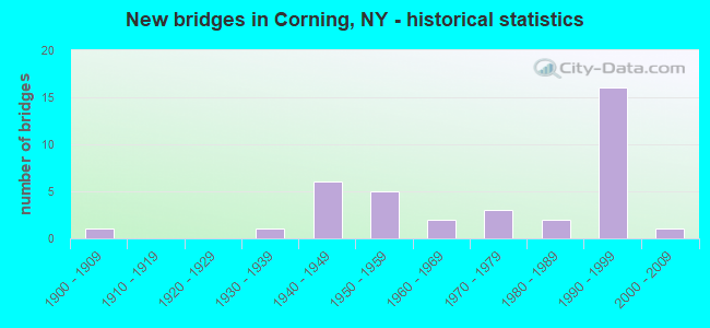
- New bridges - historical statistics
- 11900-1909
- 11930-1939
- 61940-1949
- 51950-1959
- 21960-1969
- 31970-1979
- 21980-1989
- 161990-1999
- 12000-2009
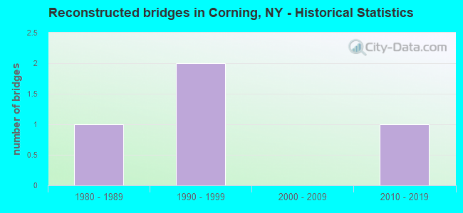
- Reconstructed bridges - Historical Statistics
- 11980-1989
- 21990-1999
- 02000-2009
- 12010-2019
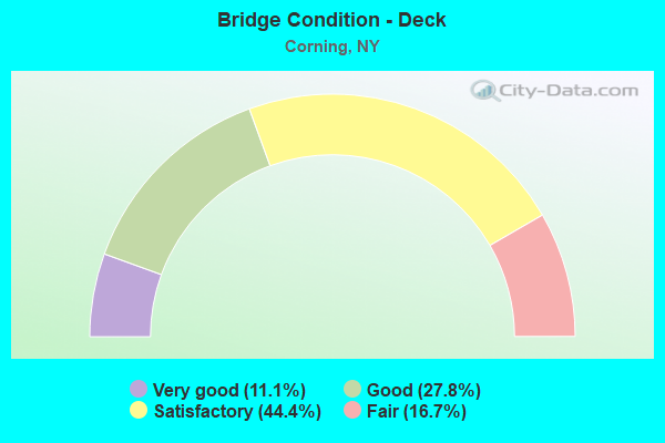
- Bridge Condition - Deck
- 11.1%Very good
- 27.8%Good
- 44.4%Satisfactory
- 16.7%Fair
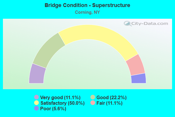
- Bridge Condition - Superstructure
- 11.1%Very good
- 22.2%Good
- 50.0%Satisfactory
- 11.1%Fair
- 5.6%Poor
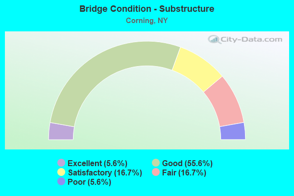
- Bridge Condition - Substructure
- 5.6%Excellent
- 55.6%Good
- 16.7%Satisfactory
- 16.7%Fair
- 5.6%Poor
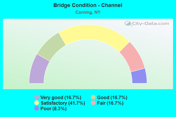
- Bridge Condition - Channel
- 16.7%Very good
- 16.7%Good
- 41.7%Satisfactory
- 16.7%Fair
- 8.3%Poor
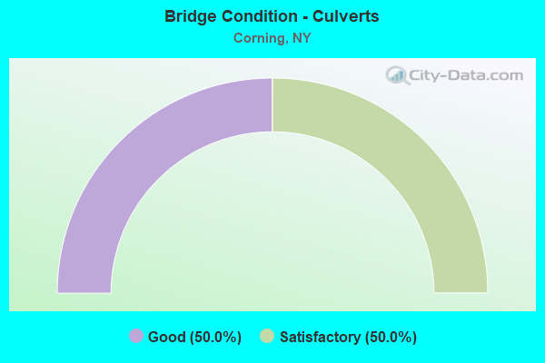
- Bridge Condition - Culverts
- 50.0%Good
- 50.0%Satisfactory
Find on map >> Show street view
Structure Number: 101272, Location: 0.3 MI E OF CORNING (Lat: 42.137628, Lng: -77.034872), Route carried "on" structure: State highway 352, Year Built: 1949, Year Reconstructed: 1990, Status: Open, Structure Length: 1.37m (4.49ft), Average Daily Traffic: 8,617 (year 2018), Truck Traffic: 4%, Average Future Daily Traffic: 8,657 (year 2040), Design Load: HS 20, Features Intersected: Trolley Lane
Minimum Vertical Clearance: 30+ m (98+ ft), Kilometerpoint: 4.312, Lanes on structure: 4, Lanes under structure: 2, Base Highway Network: Yes, Owner: State Highway Agency, Maintenance Responsibility: Private, Approaching Roadway Width: 18.9m (62.0ft), Skew: 23 degrees, Material/Design: Concrete, Design/Construction: Box Beam or Girders - Multiple, Number Of Spans In Main Unit: 1, Length of Maximum Span: 13.4m (44.0ft), Curb or Sidewalk Widths: Left: 1.8m (5.9ft), Right: 0.0m, Curb-To-Curb Width: 18.4m (60.4ft), Out-to-Out Width: 21.6m (70.9ft)
Condition: Deck: Fair, Superstructure: Satisfactory, Substructure: Fair, Operating Rating: 87.1 metric tons, Method Used To Determine Operating Rating: Load Factor (LF), Inventory Rating: 40.8 metric tons, Method Used To Determine Inventory Rating: Load Factor (LF), Structural Evaluation: Somewhat better than minimum adequacy, Deck Geometry: Somewhat better than minimum adequacy, Underclear: High priority of corrective action, Approach Roadway Alignment: Equal to present desirable criteria, Length Of Structure Improvement: 1.37m (4.49ft), Designated Inspection Frequency: Every 24 months, Inspection Date: March 2021, Bridge Improvement Cost: $1,794,000, Roadway Improvement Cost: $1,051,000, Total Project Cost: $2,845,000 ( Estimate for 2021), Deck Structure Type: Concrete Cast-file-Place, Wearing Surface/Protective System: Wearing Surface: Epoxy Overlay, Deck Protection: Epoxy Coated Reinforcing
Find on map >> Show street view
Structure Number: 1012739, Location: .4 MILE EAST OF CORNING (Lat: 42.136642, Lng: -77.030547), Route carried "on" structure: State highway 352, Year Built: 1949, Year Reconstructed: 1990, Status: Open, Structure Length: 46.21m (151.61ft), Average Daily Traffic: 8,617 (year 2018), Truck Traffic: 4%, Average Future Daily Traffic: 8,657 (year 2040), Design Load: HS 20, Features Intersected: Main Street, 86I 17 6404
Minimum Vertical Clearance: 30+ m (98+ ft), Kilometerpoint: 4.441, Lanes on structure: 4, Lanes under structure: 6, Base Highway Network: Yes, Owner: State Highway Agency, Approaching Roadway Width: 18.9m (62.0ft), Skew: 22 degrees, Material/Design: Steel continuous, Design/Construction: Stringer/Multi-beam, Number Of Spans In Main Unit: 12, Length of Maximum Span: 46.6m (152.9ft), Curb or Sidewalk Widths: Left: 1.8m (5.9ft), Right: 0.0m, Curb-To-Curb Width: 18.3m (60.0ft), Out-to-Out Width: 21.5m (70.5ft)
Condition: Deck: Satisfactory, Superstructure: Satisfactory, Substructure: Fair, Channel: Good, Operating Rating: 67.1 metric tons, Method Used To Determine Operating Rating: Load Factor (LF), Inventory Rating: 34.5 metric tons, Method Used To Determine Inventory Rating: Load Factor (LF), Structural Evaluation: Somewhat better than minimum adequacy, Deck Geometry: Somewhat better than minimum adequacy, Underclear: Meets minimum limits, Waterway Adequacy: Somewhat better than minimum adequacy, Approach Roadway Alignment: Equal to present desirable criteria, Length Of Structure Improvement: 46.20m (151.57ft), Designated Inspection Frequency: Every 24 months, Inspection Date: September 2021, Bridge Improvement Cost: $24,065,000, Roadway Improvement Cost: $14,092,000, Total Project Cost: $38,157,000 ( Estimate for 2021), Deck Structure Type: Concrete Cast-file-Place, Wearing Surface/Protective System: Wearing Surface: Integral Concrete, Deck Protection: Epoxy Coated Reinforcing
Find on map >> Show street view
Structure Number: 1072699, Location: .1 MILE EAST OF CORNING (Lat: 42.139989, Lng: -77.032558), Route carried "on" structure: Interstate 86, Year Built: 1982, Status: Open, Structure Length: 0.98m (3.22ft), Average Daily Traffic: 25,912 (year 2020), Truck Traffic: 21%, Average Future Daily Traffic: 39,777 (year 2040), Design Load: HS 20+Mod, Features Intersected: NARROWS CREEK
Minimum Vertical Clearance: 30+ m (98+ ft), Kilometerpoint: 78.487, Lanes on structure: 4, Base Highway Network: Yes, Owner: State Highway Agency, Approaching Roadway Width: 27.4m (89.9ft), Skew: 20 degrees, Material/Design: Prestressed concrete, Design/Construction: Box Beam or Girders - Multiple, Number Of Spans In Main Unit: 1, Length of Maximum Span: 8.8m (28.9ft), Curb-To-Curb Width: 27.5m (90.2ft), Out-to-Out Width: 28.6m (93.8ft)
Condition: Deck: Satisfactory, Superstructure: Satisfactory, Substructure: Good, Channel: Satisfactory, Operating Rating: 34.0 metric tons, Method Used To Determine Operating Rating: Load and Resistance Factor Rating (LRFR) rating reported by rating factor(RF) method using HL-93 loadings, Inventory Rating: 26.2 metric tons, Method Used To Determine Inventory Rating: Load and Resistance Factor Rating (LRFR) rating reported by rating factor(RF) method using HL-93 loadings, Structural Evaluation: Equal to present minimum criteria, Deck Geometry: Superior to present desirable criteria, Waterway Adequacy: Meets minimum limits, Approach Roadway Alignment: Equal to present desirable criteria, Length Of Structure Improvement: 0.97m (3.18ft), Designated Inspection Frequency: Every 24 months, Inspection Date: April 2020, Bridge Improvement Cost: $1,871,000, Roadway Improvement Cost: $1,096,000, Total Project Cost: $2,967,000 ( Estimate for 2021), Wearing Surface/Protective System: Wearing Surface: Monolithic Concrete
Find on map >> Show street view
Structure Number: 107282, Location: CITY OF CORNING (Lat: 42.152131, Lng: -77.044931), Route carried "on" structure: Interstate 86, Year Built: 1985, Status: Open, Structure Length: 7.10m (23.29ft), Average Daily Traffic: 25,912 (year 2020), Truck Traffic: 21%, Average Future Daily Traffic: 39,777 (year 2040), Design Load: HS 20, Features Intersected: POST CREEK
Minimum Vertical Clearance: 30+ m (98+ ft), Kilometerpoint: 76.717, Lanes on structure: 4, Base Highway Network: Yes, Owner: State Highway Agency, Approaching Roadway Width: 25.0m (82.0ft), Skew: 24 degrees, Material/Design: Steel continuous, Design/Construction: Stringer/Multi-beam, Number Of Spans In Main Unit: 2, Length of Maximum Span: 35.0m (114.8ft), Curb-To-Curb Width: 25.0m (82.0ft), Out-to-Out Width: 26.2m (86.0ft)
Condition: Deck: Good, Superstructure: Satisfactory, Substructure: Good, Channel: Good, Operating Rating: 80.7 metric tons, Method Used To Determine Operating Rating: Load Factor (LF), Inventory Rating: 48.1 metric tons, Method Used To Determine Inventory Rating: Load Factor (LF), Structural Evaluation: Equal to present minimum criteria, Deck Geometry: Superior to present desirable criteria, Waterway Adequacy: Equal to present minimum criteria, Approach Roadway Alignment: Equal to present desirable criteria, Length Of Structure Improvement: 7.10m (23.29ft), Designated Inspection Frequency: Every 24 months, Inspection Date: May 2020, Bridge Improvement Cost: $5,745,000, Roadway Improvement Cost: $3,364,000, Total Project Cost: $9,110,000 ( Estimate for 2021), Deck Structure Type: Concrete Cast-file-Place, Wearing Surface/Protective System: Wearing Surface: Epoxy Overlay, Deck Protection: Epoxy Coated Reinforcing
Find on map >> Show street view
Structure Number: 1074851, Location: WB STE OVER REYNOLDS AVE (Lat: 42.162453, Lng: -77.070267), Route carried "on" structure: Interstate 86, Year Built: 1995, Status: Open, Structure Length: 2.35m (7.71ft), Average Daily Traffic: 16,319 (year 2014), Truck Traffic: 21%, Design Load: HS 25 or greater, Features Intersected: REYNOLDS AVENUE
Minimum Vertical Clearance: 30+ m (98+ ft), Kilometerpoint: 74.175, Lanes on structure: 2, Lanes under structure: 2, Base Highway Network: Yes, Owner: State Highway Agency, Approaching Roadway Width: 12.2m (40.0ft), Skew: 2 degrees, Material/Design: Steel, Design/Construction: Stringer/Multi-beam, Number Of Spans In Main Unit: 1, Length of Maximum Span: 22.2m (72.8ft), Curb-To-Curb Width: 12.3m (40.4ft), Out-to-Out Width: 13.2m (43.3ft)
Condition: Deck: Good, Superstructure: Satisfactory, Substructure: Good, Operating Rating: 74.4 metric tons, Method Used To Determine Operating Rating: Load Factor (LF), Inventory Rating: 44.5 metric tons, Method Used To Determine Inventory Rating: Load Factor (LF), Structural Evaluation: Equal to present minimum criteria, Deck Geometry: Better than present minimum criteria, Underclear: Somewhat better than minimum adequacy, Approach Roadway Alignment: Equal to present desirable criteria, Length Of Structure Improvement: 2.34m (7.68ft), Designated Inspection Frequency: Every 24 months, Inspection Date: October 2021, Bridge Improvement Cost: $1,113,000, Roadway Improvement Cost: $652,000, Total Project Cost: $1,765,000 ( Estimate for 2021), Deck Structure Type: Concrete Cast-file-Place, Wearing Surface/Protective System: Wearing Surface: Integral Concrete, Deck Protection: Epoxy Coated Reinforcing
Find on map >> Show street view
Structure Number: 1074852, Location: EB STE OVER REYNOLDS AVE (Lat: 42.162331, Lng: -77.070258), Route carried "on" structure: Interstate 86, Year Built: 1995, Status: Open, Structure Length: 2.35m (7.71ft), Average Daily Traffic: 13,805 (year 2019), Truck Traffic: 19%, Average Future Daily Traffic: 21,191 (year 2040), Design Load: HS 25 or greater, Features Intersected: REYNOLDS AVENUE
Minimum Vertical Clearance: 30+ m (98+ ft), Kilometerpoint: 74.046, Lanes on structure: 2, Lanes under structure: 2, Base Highway Network: Yes, Owner: State Highway Agency, Approaching Roadway Width: 12.2m (40.0ft), Skew: 2 degrees, Material/Design: Steel, Design/Construction: Stringer/Multi-beam, Number Of Spans In Main Unit: 1, Length of Maximum Span: 22.2m (72.8ft), Curb-To-Curb Width: 12.3m (40.4ft), Out-to-Out Width: 13.2m (43.3ft)
Condition: Deck: Good, Superstructure: Satisfactory, Substructure: Good, Operating Rating: 74.4 metric tons, Method Used To Determine Operating Rating: Load Factor (LF), Inventory Rating: 44.5 metric tons, Method Used To Determine Inventory Rating: Load Factor (LF), Structural Evaluation: Equal to present minimum criteria, Deck Geometry: Better than present minimum criteria, Underclear: Somewhat better than minimum adequacy, Approach Roadway Alignment: Equal to present desirable criteria, Length Of Structure Improvement: 2.34m (7.68ft), Designated Inspection Frequency: Every 24 months, Inspection Date: October 2021, Bridge Improvement Cost: $1,113,000, Roadway Improvement Cost: $652,000, Total Project Cost: $1,765,000 ( Estimate for 2021), Deck Structure Type: Concrete Cast-file-Place, Wearing Surface/Protective System: Wearing Surface: Integral Concrete, Deck Protection: Epoxy Coated Reinforcing
Find on map >> Show street view
Structure Number: 1074861, Location: 1MI W RT414 & WINFIELD ST (Lat: 42.162686, Lng: -77.059892), Route carried "on" structure: State highway 86, Year Built: 1994, Status: Open, Structure Length: 3.75m (12.30ft), Average Daily Traffic: 16,319 (year 2014), Truck Traffic: 21%, Design Load: HS 20+Mod, Features Intersected: RELOC WINFIELD ST
Minimum Vertical Clearance: 30+ m (98+ ft), Kilometerpoint: 75.028, Lanes on structure: 3, Lanes under structure: 2, Base Highway Network: Yes, Owner: State Highway Agency, Approaching Roadway Width: 14.3m (46.9ft), Skew: 5 degrees, Material/Design: Steel, Design/Construction: Stringer/Multi-beam, Number Of Spans In Main Unit: 1, Length of Maximum Span: 36.8m (120.7ft), Curb-To-Curb Width: 14.1m (46.3ft), Out-to-Out Width: 15.0m (49.2ft)
Condition: Deck: Satisfactory, Superstructure: Satisfactory, Substructure: Good, Operating Rating: 70.8 metric tons, Method Used To Determine Operating Rating: Load Factor (LF), Inventory Rating: 32.7 metric tons, Method Used To Determine Inventory Rating: Load Factor (LF), Structural Evaluation: Equal to present minimum criteria, Deck Geometry: Meets minimum limits, Underclear: Somewhat better than minimum adequacy, Approach Roadway Alignment: Equal to present desirable criteria, Length Of Structure Improvement: 3.74m (12.27ft), Designated Inspection Frequency: Every 24 months, Inspection Date: May 2020, Bridge Improvement Cost: $1,758,000, Roadway Improvement Cost: $1,030,000, Total Project Cost: $2,788,000 ( Estimate for 2021), Deck Structure Type: Concrete Cast-file-Place, Wearing Surface/Protective System: Wearing Surface: Epoxy Overlay, Deck Protection: Epoxy Coated Reinforcing
Find on map >> Show street view
Structure Number: 1074862, Location: 1M W RT414 & WINFIELD ST (Lat: 42.162656, Lng: -77.060178), Route carried "on" structure: State highway 86, Year Built: 1994, Status: Open, Structure Length: 3.57m (11.71ft), Average Daily Traffic: 13,805 (year 2019), Truck Traffic: 19%, Average Future Daily Traffic: 21,191 (year 2040), Design Load: HS 20+Mod, Features Intersected: RELOC WINFIELD ST
Minimum Vertical Clearance: 30+ m (98+ ft), Kilometerpoint: 74.915, Lanes on structure: 2, Lanes under structure: 2, Base Highway Network: Yes, Owner: State Highway Agency, Approaching Roadway Width: 12.5m (41.0ft), Skew: 5 degrees, Material/Design: Steel, Design/Construction: Stringer/Multi-beam, Number Of Spans In Main Unit: 1, Length of Maximum Span: 35.0m (114.8ft), Curb-To-Curb Width: 12.4m (40.7ft), Out-to-Out Width: 13.2m (43.3ft)
Condition: Deck: Satisfactory, Superstructure: Satisfactory, Substructure: Good, Operating Rating: 70.8 metric tons, Method Used To Determine Operating Rating: Load Factor (LF), Inventory Rating: 32.7 metric tons, Method Used To Determine Inventory Rating: Load Factor (LF), Structural Evaluation: Equal to present minimum criteria, Deck Geometry: Better than present minimum criteria, Underclear: Somewhat better than minimum adequacy, Approach Roadway Alignment: Equal to present desirable criteria, Length Of Structure Improvement: 3.56m (11.68ft), Designated Inspection Frequency: Every 24 months, Inspection Date: May 2020, Bridge Improvement Cost: $1,489,000, Roadway Improvement Cost: $872,000, Total Project Cost: $2,361,000 ( Estimate for 2021), Deck Structure Type: Concrete Cast-file-Place, Wearing Surface/Protective System: Wearing Surface: Epoxy Overlay, Deck Protection: Epoxy Coated Reinforcing
Find on map >> Show street view
Structure Number: 1074881, Location: 1.2MI N JCT RTS 414 & 415 (Lat: 42.154856, Lng: -77.053056), Route carried "on" structure: Interstate 86, Year Built: 1994, Status: Open, Structure Length: 2.71m (8.89ft), Average Daily Traffic: 16,319 (year 2014), Truck Traffic: 21%, Design Load: HS 20+Mod, Features Intersected: RTE 414
Minimum Vertical Clearance: 30+ m (98+ ft), Kilometerpoint: 76.138, Lanes on structure: 2, Lanes under structure: 4, Base Highway Network: Yes, Owner: State Highway Agency, Approaching Roadway Width: 12.5m (41.0ft), Skew: 2 degrees, Material/Design: Steel, Design/Construction: Stringer/Multi-beam, Number Of Spans In Main Unit: 1, Length of Maximum Span: 25.9m (85.0ft), Curb-To-Curb Width: 12.4m (40.7ft), Out-to-Out Width: 13.2m (43.3ft)
Condition: Deck: Satisfactory, Superstructure: Good, Substructure: Good, Operating Rating: 68.0 metric tons, Method Used To Determine Operating Rating: Load Factor (LF), Inventory Rating: 35.4 metric tons, Method Used To Determine Inventory Rating: Load Factor (LF), Structural Evaluation: Better than present minimum criteria, Deck Geometry: Better than present minimum criteria, Underclear: Equal to present minimum criteria, Approach Roadway Alignment: Equal to present desirable criteria, Length Of Structure Improvement: 2.71m (8.89ft), Designated Inspection Frequency: Every 24 months, Inspection Date: July 2020, Bridge Improvement Cost: $1,938,000, Roadway Improvement Cost: $1,135,000, Total Project Cost: $3,073,000 ( Estimate for 2021), Deck Structure Type: Concrete Cast-file-Place, Wearing Surface/Protective System: Wearing Surface: Integral Concrete, Deck Protection: Epoxy Coated Reinforcing
Find on map >> Show street view
Structure Number: 1074882, Location: 0.2MI N JCT RTS 414 & 415 (Lat: 42.154750, Lng: -77.053078), Route carried "on" structure: Interstate 86, Year Built: 1994, Status: Open, Structure Length: 2.71m (8.89ft), Average Daily Traffic: 13,805 (year 2019), Truck Traffic: 19%, Average Future Daily Traffic: 21,191 (year 2040), Design Load: HS 20+Mod, Features Intersected: RTE 414
Minimum Vertical Clearance: 30+ m (98+ ft), Kilometerpoint: 75.993, Lanes on structure: 2, Lanes under structure: 4, Base Highway Network: Yes, Owner: State Highway Agency, Approaching Roadway Width: 12.5m (41.0ft), Skew: 2 degrees, Material/Design: Steel, Design/Construction: Stringer/Multi-beam, Number Of Spans In Main Unit: 1, Length of Maximum Span: 25.9m (85.0ft), Curb-To-Curb Width: 12.3m (40.4ft), Out-to-Out Width: 13.2m (43.3ft)
Condition: Deck: Satisfactory, Superstructure: Good, Substructure: Good, Operating Rating: 68.0 metric tons, Method Used To Determine Operating Rating: Load Factor (LF), Inventory Rating: 35.4 metric tons, Method Used To Determine Inventory Rating: Load Factor (LF), Structural Evaluation: Better than present minimum criteria, Deck Geometry: Better than present minimum criteria, Underclear: Equal to present minimum criteria, Approach Roadway Alignment: Equal to present desirable criteria, Length Of Structure Improvement: 2.71m (8.89ft), Designated Inspection Frequency: Every 24 months, Inspection Date: July 2020, Bridge Improvement Cost: $1,978,000, Roadway Improvement Cost: $1,158,000, Total Project Cost: $3,136,000 ( Estimate for 2021), Deck Structure Type: Concrete Cast-file-Place, Wearing Surface/Protective System: Wearing Surface: Integral Concrete, Deck Protection: Epoxy Coated Reinforcing
Find on map >> Show street view
Structure Number: 107489, Location: 3.2 MI E JCT SR 415 & I86 (Lat: 42.156792, Lng: -77.055511), Route carried "on" structure: Interstate 86, Year Built: 1994, Status: Open, Structure Length: 2.44m (8.01ft), Average Daily Traffic: 27,444 (year 2015), Truck Traffic: 21%, Average Future Daily Traffic: 38,422 (year 2035), Design Load: HS 20+Mod, Features Intersected: NORFOLK SOUTHERN
Minimum Vertical Clearance: 30+ m (98+ ft), Kilometerpoint: 72.131, Lanes on structure: 5, Base Highway Network: Yes, Owner: State Highway Agency, Approaching Roadway Width: 33.5m (109.9ft), Skew: 24 degrees, Material/Design: Prestressed concrete, Design/Construction: Box Beam or Girders - Multiple, Number Of Spans In Main Unit: 1, Length of Maximum Span: 24.1m (79.1ft), Curb-To-Curb Width: 33.5m (109.9ft), Out-to-Out Width: 35.1m (115.2ft)
Condition: Deck: Fair, Superstructure: Satisfactory, Substructure: Good, Operating Rating: 80.7 metric tons, Method Used To Determine Operating Rating: Load Factor (LF), Inventory Rating: 32.7 metric tons, Method Used To Determine Inventory Rating: Load Factor (LF), Structural Evaluation: Equal to present minimum criteria, Deck Geometry: Superior to present desirable criteria, Underclear: Better than present minimum criteria, Approach Roadway Alignment: Equal to present desirable criteria, Length Of Structure Improvement: 2.52m (8.27ft), Designated Inspection Frequency: Every 24 months, Inspection Date: September 2021, Bridge Improvement Cost: $6,045,000, Roadway Improvement Cost: $3,540,000, Total Project Cost: $9,584,000 ( Estimate for 2021), Deck Structure Type: Concrete Cast-file-Place, Wearing Surface/Protective System: Wearing Surface: Bituminous, Deck Protection: Epoxy Coated Reinforcing
Find on map >> Show street view
Structure Number: 10749, Location: .1 MI N JCT SR17 & SR414 (Lat: 42.155697, Lng: -77.053172), Route carried "on" structure: State highway 414, Year Built: 1993, Status: Open, Structure Length: 34.08m (111.81ft), Average Daily Traffic: 6,210 (year 2019), Truck Traffic: 9%, Average Future Daily Traffic: 7,543 (year 2040), Design Load: HS 20+Mod, Features Intersected: NORFOLK SOUTHERN, POST C
Minimum Vertical Clearance: 30+ m (98+ ft), Kilometerpoint: 1.464, Lanes on structure: 4, Base Highway Network: Yes, Owner: State Highway Agency, Approaching Roadway Width: 15.8m (51.8ft), Skew: 20 degrees, Material/Design: Steel continuous, Design/Construction: Stringer/Multi-beam, Number Of Spans In Main Unit: 6, Length of Maximum Span: 58.2m (190.9ft), Curb-To-Curb Width: 15.7m (51.5ft), Out-to-Out Width: 16.6m (54.5ft)
Condition: Deck: Satisfactory, Superstructure: Good, Substructure: Satisfactory, Channel: Very good, Operating Rating: 61.7 metric tons, Method Used To Determine Operating Rating: Load Factor (LF), Inventory Rating: 33.6 metric tons, Method Used To Determine Inventory Rating: Load Factor (LF), Structural Evaluation: Equal to present minimum criteria, Deck Geometry: Meets minimum limits, Underclear: Better than present minimum criteria, Waterway Adequacy: Equal to present minimum criteria, Approach Roadway Alignment: Equal to present desirable criteria, Length Of Structure Improvement: 34.07m (111.78ft), Designated Inspection Frequency: Every 24 months, Inspection Date: July 2021, Bridge Improvement Cost: $14,442,000, Roadway Improvement Cost: $8,457,000, Total Project Cost: $22,899,000 ( Estimate for 2021), Deck Structure Type: Concrete Cast-file-Place, Wearing Surface/Protective System: Wearing Surface: Integral Concrete, Deck Protection: Epoxy Coated Reinforcing
Find on map >> Show street view
Structure Number: 121808, Location: IN CORNING (Lat: 42.146233, Lng: -77.052614), Route carried "on" structure: State highway 414, Year Built: 1979, Status: Open, Structure Length: 29.78m (97.70ft), Average Daily Traffic: 5,992 (year 2020), Truck Traffic: 4%, Average Future Daily Traffic: 7,279 (year 2040), Design Load: HS 20, Features Intersected: Pedestrian Sidewalk, CHE
Minimum Vertical Clearance: 30+ m (98+ ft), Kilometerpoint: 0.209, Lanes on structure: 4, Base Highway Network: Yes, Owner: State Highway Agency, Approaching Roadway Width: 17.1m (56.1ft), Skew: 23 degrees, Material/Design: Steel continuous, Design/Construction: Stringer/Multi-beam, Number Of Spans In Main Unit: 5, Length of Maximum Span: 65.8m (215.9ft), Curb or Sidewalk Widths: Left: 2.4m (7.9ft), Right: 2.4m (7.9ft), Curb-To-Curb Width: 17.1m (56.1ft), Out-to-Out Width: 22.7m (74.5ft)
Condition: Deck: Satisfactory, Superstructure: Fair, Substructure: Good, Channel: Satisfactory, Operating Rating: 51.5 metric tons, Method Used To Determine Operating Rating: Load and Resistance Factor Rating (LRFR) rating reported by rating factor(RF) method using HL-93 loadings, Inventory Rating: 39.9 metric tons, Method Used To Determine Inventory Rating: Load and Resistance Factor Rating (LRFR) rating reported by rating factor(RF) method using HL-93 loadings, Structural Evaluation: Somewhat better than minimum adequacy, Deck Geometry: Somewhat better than minimum adequacy, Waterway Adequacy: Equal to present desirable criteria, Approach Roadway Alignment: Equal to present desirable criteria, Length Of Structure Improvement: 29.77m (97.67ft), Designated Inspection Frequency: Every 24 months, Inspection Date: August 2020, Bridge Improvement Cost: $17,020,000, Roadway Improvement Cost: $9,967,000, Total Project Cost: $26,988,000 ( Estimate for 2021), Deck Structure Type: Concrete Cast-file-Place, Wearing Surface/Protective System: Wearing Surface: Epoxy Overlay, Deck Protection: Epoxy Coated Reinforcing
Find on map >> Show street view
Structure Number: 221809, Location: IN CORNING (Lat: 42.148278, Lng: -77.060744), Route carried "on" structure: City street , Year Built: 1937, Year Reconstructed: 2019, Status: Posted for load-capacity, Structure Length: 17.62m (57.81ft), Average Daily Traffic: 7,645 (year 2017), Truck Traffic: 2%, Average Future Daily Traffic: 9,459 (year 2040), Design Load: HS 20, Features Intersected: CHEMUNG RIVER, Facility Carried by Structure: BRIDGE STREET
Minimum Vertical Clearance: 4.93m (16.17ft), Kilometerpoint: 0.306, Lanes on structure: 2, Owner: City or Municipal Highway Agency, Approaching Roadway Width: 11.3m (37.1ft), Material/Design: Steel continuous, Design/Construction: Truss - Thru, Number Of Spans In Main Unit: 3, Length of Maximum Span: 67.9m (222.8ft), Curb or Sidewalk Widths: Left: 1.8m (5.9ft), Right: 1.8m (5.9ft), Curb-To-Curb Width: 11.4m (37.4ft), Out-to-Out Width: 12.7m (41.7ft)
Condition: Deck: Good, Superstructure: Fair, Substructure: Satisfactory, Channel: Satisfactory, Operating Rating: 56.2 metric tons, Method Used To Determine Operating Rating: Load Factor (LF), Inventory Rating: 33.6 metric tons, Method Used To Determine Inventory Rating: Load Factor (LF), Structural Evaluation: Somewhat better than minimum adequacy, Deck Geometry: Meets minimum limits, Waterway Adequacy: Equal to present desirable criteria, Approach Roadway Alignment: Equal to present minimum criteria, Length Of Structure Improvement: 17.80m (58.40ft), Designated Inspection Frequency: Every 24 months, Critical Feature Inspection Frequency: Every 24 months, Inspection Date: November 2021, Critical Feature Inspection Date: November 2021, Bridge Improvement Cost: $15,655,000, Roadway Improvement Cost: $9,168,000, Total Project Cost: $24,823,000 ( Estimate for 2021), Deck Structure Type: Concrete Cast-file-Place, Wearing Surface/Protective System: Wearing Surface: Integral Concrete, Deck Protection: Epoxy Coated Reinforcing
Find on map >> Show street view
Structure Number: 221811, Location: DENMARK HILL ACCESS ROAD (Lat: 42.161500, Lng: -77.053464), Route carried "on" structure: City street , Year Built: 1991, Status: Open, Structure Length: 15.79m (51.80ft), Average Daily Traffic: 130 (year 2018), Truck Traffic: 3%, Average Future Daily Traffic: 182 (year 2038), Design Load: HS 20, Features Intersected: NORFOLK SOUTHERN, POST C, Facility Carried by Structure: HIGH STREET
Minimum Vertical Clearance: 30+ m (98+ ft), Kilometerpoint: 0.048, Lanes on structure: 2, Owner: City or Municipal Highway Agency, Approaching Roadway Width: 8.5m (27.9ft), Material/Design: Steel, Design/Construction: Stringer/Multi-beam, Number Of Spans In Main Unit: 4, Length of Maximum Span: 53.3m (174.9ft), Curb-To-Curb Width: 8.3m (27.2ft), Out-to-Out Width: 9.3m (30.5ft)
Condition: Deck: Good, Superstructure: Good, Substructure: Fair, Channel: Satisfactory, Operating Rating: 76.2 metric tons, Method Used To Determine Operating Rating: Load Factor (LF), Inventory Rating: 32.7 metric tons, Method Used To Determine Inventory Rating: Load Factor (LF), Structural Evaluation: Somewhat better than minimum adequacy, Deck Geometry: Somewhat better than minimum adequacy, Underclear: Superior to present desirable criteria, Waterway Adequacy: Somewhat better than minimum adequacy, Approach Roadway Alignment: Equal to present desirable criteria, Length Of Structure Improvement: 15.78m (51.77ft), Designated Inspection Frequency: Every 24 months, Inspection Date: July 2021, Bridge Improvement Cost: $3,627,000, Roadway Improvement Cost: $2,124,000, Total Project Cost: $5,751,000 ( Estimate for 2021), Deck Structure Type: Concrete Cast-file-Place, Wearing Surface/Protective System: Wearing Surface: Integral Concrete, Deck Protection: Epoxy Coated Reinforcing
Find on map >> Show street view
Structure Number: 226945, Location: .3 MI SE JCT SH352 &SH225 (Lat: 42.136925, Lng: -77.035219), Route carried "on" structure: Other road , Year Built: 2004, Status: Open, Structure Length: 0.79m (2.59ft), Average Daily Traffic: 487 (year 2020), Truck Traffic: 1%, Average Future Daily Traffic: 682 (year 2040), Features Intersected: DENISON LAKE, Facility Carried by Structure: RELIHAN BOULEVARD
Minimum Vertical Clearance: 30+ m (98+ ft), Kilometerpoint: 0.499, Lanes on structure: 2, Owner: City or Municipal Highway Agency, Approaching Roadway Width: 6.1m (20.0ft), Material/Design: Concrete, Design/Construction: Frame, Number Of Spans In Main Unit: 1, Length of Maximum Span: 7.6m (24.9ft), Curb-To-Curb Width: 6.1m (20.0ft), Out-to-Out Width: 6.7m (22.0ft)
Condition: Deck: Very good, Superstructure: Very good, Substructure: Excellent, Channel: Very good, Operating Rating: 68.1 metric tons, Method Used To Determine Operating Rating: Load Factor (LF), Inventory Rating: 40.8 metric tons, Method Used To Determine Inventory Rating: Load Factor (LF), Structural Evaluation: Equal to present desirable criteria, Deck Geometry: High priority of corrective action, Waterway Adequacy: Superior to present desirable criteria, Approach Roadway Alignment: Meets minimum limits, Length Of Structure Improvement: 0.79m (2.59ft), Designated Inspection Frequency: Every 24 months, Inspection Date: September 2020, Bridge Improvement Cost: $169,000, Roadway Improvement Cost: $99,000, Total Project Cost: $267,000 ( Estimate for 2021), Wearing Surface/Protective System: Wearing Surface: Bituminous
Find on map >> Show street view
Structure Number: 333364, Location: 1.3 MI E OF PAINTED POST (Lat: 42.164369, Lng: -77.071575), Route carried "on" structure: County highway , Year Built: 1977, Year Reconstructed: 1992, Status: Posted for load-capacity, Structure Length: 1.83m (6.00ft), Average Daily Traffic: 1,350 (year 2018), Truck Traffic: 7%, Average Future Daily Traffic: 1,670 (year 2040), Design Load: HS 20, Features Intersected: CUTLER CREEK, Facility Carried by Structure: COUNTY ROAD 41
Minimum Vertical Clearance: 30+ m (98+ ft), Kilometerpoint: 1.223, Lanes on structure: 2, Owner: County Highway Agency, Approaching Roadway Width: 5.5m (18.0ft), Material/Design: Steel, Design/Construction: Stringer/Multi-beam, Number Of Spans In Main Unit: 1, Length of Maximum Span: 17.6m (57.7ft), Curb-To-Curb Width: 7.4m (24.3ft), Out-to-Out Width: 7.6m (24.9ft)
Condition: Deck: Fair, Superstructure: Poor, Substructure: Poor, Channel: Fair, Operating Rating: 80.1 metric tons, Method Used To Determine Operating Rating: Field evaluation and documented engineering judgment, Inventory Rating: 19.6 metric tons, Method Used To Determine Inventory Rating: Field evaluation and documented engineering judgment, Structural Evaluation: Meets minimum limits, Deck Geometry: Meets minimum limits, Waterway Adequacy: Equal to present desirable criteria, Approach Roadway Alignment: Better than present minimum criteria, Length Of Structure Improvement: 1.82m (5.97ft), Designated Inspection Frequency: Every 24 months, Inspection Date: June 2020, Bridge Improvement Cost: $401,000, Roadway Improvement Cost: $235,000, Total Project Cost: $636,000 ( Estimate for 2021), Deck Structure Type: Wood or Timber, Wearing Surface/Protective System: Wearing Surface: Bituminous, Membrane: Other
Find on map >> Show street view
Structure Number: 333365, Location: 1.7 MI NE OF PAINTED POST (Lat: 42.177364, Lng: -77.066050), Route carried "on" structure: County highway , Year Built: 1964, Status: Open, Structure Length: 1.52m (4.99ft), Average Daily Traffic: 1,232 (year 2018), Truck Traffic: 7%, Average Future Daily Traffic: 1,285 (year 2040), Design Load: HS 20+Mod, Features Intersected: CUTLER CREEK, Facility Carried by Structure: COUNTY ROAD 41
Minimum Vertical Clearance: 30+ m (98+ ft), Kilometerpoint: 2.880, Lanes on structure: 2, Owner: County Highway Agency, Approaching Roadway Width: 9.1m (29.9ft), Skew: 4 degrees, Material/Design: Concrete continuous, Design/Construction: Culvert, Number Of Spans In Main Unit: 2, Length of Maximum Span: 7.3m (24.0ft), Curb-To-Curb Width: 7.9m (25.9ft), Out-to-Out Width: 14.1m (46.3ft)
Condition: Channel: Fair, Culverts: Satisfactory, Operating Rating: 52.6 metric tons, Method Used To Determine Operating Rating: Load Factor (LF), Inventory Rating: 14.5 metric tons, Method Used To Determine Inventory Rating: Load Factor (LF), Structural Evaluation: Meets minimum limits, Deck Geometry: Meets minimum limits, Waterway Adequacy: Meets minimum limits, Approach Roadway Alignment: Better than present minimum criteria, Length Of Structure Improvement: 1.40m (4.59ft), Designated Inspection Frequency: Every 24 months, Inspection Date: September 2021, Bridge Improvement Cost: $675,000, Roadway Improvement Cost: $395,000, Total Project Cost: $1,070,000 ( Estimate for 2021)
Find on map >> Show street view
Structure Number: 333366, Location: 2.1 MI NE OF PAINTED POST (Lat: 42.180561, Lng: -77.064600), Route carried "on" structure: County highway , Year Built: 1964, Status: Open, Structure Length: 1.01m (3.31ft), Average Daily Traffic: 1,232 (year 2018), Truck Traffic: 7%, Average Future Daily Traffic: 1,285 (year 2040), Design Load: HS 20+Mod, Features Intersected: BORDEN CREEK, Facility Carried by Structure: COUNTY ROAD 41
Minimum Vertical Clearance: 30+ m (98+ ft), Kilometerpoint: 3.266, Lanes on structure: 2, Owner: County Highway Agency, Approaching Roadway Width: 6.4m (21.0ft), Skew: 4 degrees, Material/Design: Concrete continuous, Design/Construction: Culvert, Number Of Spans In Main Unit: 2, Length of Maximum Span: 4.6m (15.1ft), Curb-To-Curb Width: 11.0m (36.1ft), Out-to-Out Width: 11.9m (39.0ft)
Condition: Channel: Satisfactory, Culverts: Good, Operating Rating: 82.6 metric tons, Method Used To Determine Operating Rating: Load Factor (LF), Inventory Rating: 38.1 metric tons, Method Used To Determine Inventory Rating: Load Factor (LF), Structural Evaluation: Better than present minimum criteria, Deck Geometry: Equal to present minimum criteria, Waterway Adequacy: Somewhat better than minimum adequacy, Approach Roadway Alignment: Equal to present minimum criteria, Length Of Structure Improvement: 1.00m (3.28ft), Designated Inspection Frequency: Every 24 months, Inspection Date: September 2021, Bridge Improvement Cost: $615,000, Roadway Improvement Cost: $360,000, Total Project Cost: $976,000 ( Estimate for 2021)
Find on map >> Show street view
Structure Number: 33337, Location: IN GIBSON (Lat: 42.143756, Lng: -77.028367), Route carried "on" structure: County highway , Year Built: 1991, Status: Open, Structure Length: 1.58m (5.18ft), Average Daily Traffic: 427 (year 2020), Truck Traffic: 5%, Average Future Daily Traffic: 598 (year 2040), Design Load: HS 25 or greater, Features Intersected: NARROWS CREEK, Facility Carried by Structure: COUNTY ROAD 45
Minimum Vertical Clearance: 30+ m (98+ ft), Kilometerpoint: 0.499, Lanes on structure: 2, Owner: County Highway Agency, Approaching Roadway Width: 6.4m (21.0ft), Skew: 3 degrees, Material/Design: Prestressed concrete, Design/Construction: Box Beam or Girders - Multiple, Number Of Spans In Main Unit: 1, Length of Maximum Span: 15.2m (49.9ft), Curb-To-Curb Width: 9.1m (29.9ft), Out-to-Out Width: 9.9m (32.5ft)
Condition: Deck: Very good, Superstructure: Very good, Substructure: Satisfactory, Channel: Poor, Operating Rating: 87.1 metric tons, Method Used To Determine Operating Rating: Load Factor (LF), Inventory Rating: 42.6 metric tons, Method Used To Determine Inventory Rating: Load Factor (LF), Structural Evaluation: Equal to present minimum criteria, Deck Geometry: Equal to present minimum criteria, Waterway Adequacy: High priority of corrective action, Approach Roadway Alignment: Equal to present minimum criteria, Length Of Structure Improvement: 1.58m (5.18ft), Designated Inspection Frequency: Every 24 months, Inspection Date: September 2021, Bridge Improvement Cost: $515,000, Roadway Improvement Cost: $302,000, Total Project Cost: $817,000 ( Estimate for 2021), Wearing Surface/Protective System: Wearing Surface: Bituminous, Membrane: Other
Find on map >> Show street view
Structure Number: 101272, Location: 0.3 MI E OF CORNING (Lat: 42.137628, Lng: -77.034872), Route carried "under" structure: ServiceOther road , Year Built: 1949, Structure Length: 0. m, Average Daily Traffic: 25 (year 2021), Features Intersected: Trolley Lane, Facility Carried by Structure: RTE 352
Minimum Vertical Clearance: 4.22m (13.85ft), Kilometerpoint: 0.000, Lanes on structure: 4, Lanes under structure: 2, Material/Design: Concrete, Design/Construction: Box Beam or Girders - Multiple, Length of Maximum Span: 13.4m (44.0ft)
Find on map >> Show street view
Structure Number: 1012739, Location: .4 MILE EAST OF CORNING (Lat: 42.136642, Lng: -77.030547), Route carried "under" structure: Interstate 86, Year Built: 1949, Structure Length: 0. m, Average Daily Traffic: 22,921 (year 1983), Features Intersected: Main Street, 86I 17 6404, Facility Carried by Structure: RTE 352
Minimum Vertical Clearance: 6.91m (22.67ft), Kilometerpoint: 3.813, Lanes on structure: 4, Lanes under structure: 2, Material/Design: Steel continuous, Design/Construction: Stringer/Multi-beam, Length of Maximum Span: 46.6m (152.9ft)
Find on map >> Show street view
Structure Number: 1012739, Location: .4 MILE EAST OF CORNING (Lat: 42.136642, Lng: -77.030547), Route carried "under" structure: Interstate , Year Built: 1949, Structure Length: 0. m, Features Intersected: Main Street, 86I 17 6404, Facility Carried by Structure: RTE 352
Minimum Vertical Clearance: 7.47m (24.51ft), Kilometerpoint: 3.813, Lanes on structure: 4, Lanes under structure: 2, Material/Design: Steel continuous, Design/Construction: Stringer/Multi-beam, Length of Maximum Span: 46.6m (152.9ft)
Find on map >> Show street view
Structure Number: 1074851, Location: WB STE OVER REYNOLDS AVE (Lat: 42.162453, Lng: -77.070267), Route carried "under" structure: City street , Year Built: 1995, Structure Length: 0. m, Features Intersected: REYNOLDS AVENUE, Facility Carried by Structure: RTE I86
Minimum Vertical Clearance: 7.39m (24.25ft), Kilometerpoint: 0.917, Lanes on structure: 2, Lanes under structure: 2, Material/Design: Steel, Design/Construction: Stringer/Multi-beam, Length of Maximum Span: 22.2m (72.8ft)
Find on map >> Show street view
Structure Number: 1074852, Location: EB STE OVER REYNOLDS AVE (Lat: 42.162331, Lng: -77.070258), Route carried "under" structure: City street , Year Built: 1995, Structure Length: 0. m, Average Daily Traffic: 1,000 (year 2021), Features Intersected: REYNOLDS AVENUE, Facility Carried by Structure: RTE I86
Minimum Vertical Clearance: 6.76m (22.18ft), Kilometerpoint: 0.000, Lanes on structure: 2, Lanes under structure: 2, Material/Design: Steel, Design/Construction: Stringer/Multi-beam, Length of Maximum Span: 22.2m (72.8ft)
Find on map >> Show street view
Structure Number: 1074861, Location: 1MI W RT414 & WINFIELD ST (Lat: 42.162686, Lng: -77.059892), Route carried "under" structure: City street , Year Built: 1994, Structure Length: 0. m, Average Daily Traffic: 500 (year 2021), Features Intersected: RELOC WINFIELD ST, Facility Carried by Structure: RTE I86
Minimum Vertical Clearance: 4.80m (15.75ft), Kilometerpoint: 0.000, Lanes on structure: 3, Lanes under structure: 2, Material/Design: Steel, Design/Construction: Stringer/Multi-beam, Length of Maximum Span: 36.8m (120.7ft)
Find on map >> Show street view
Structure Number: 1074862, Location: 1M W RT414 & WINFIELD ST (Lat: 42.162656, Lng: -77.060178), Route carried "under" structure: City street , Year Built: 1994, Structure Length: 0. m, Average Daily Traffic: 500 (year 2021), Features Intersected: RELOC WINFIELD ST, Facility Carried by Structure: RTE I86
Minimum Vertical Clearance: 4.50m (14.76ft), Kilometerpoint: 0.000, Lanes on structure: 2, Lanes under structure: 2, Material/Design: Steel, Design/Construction: Stringer/Multi-beam, Length of Maximum Span: 35.0m (114.8ft)
Find on map >> Show street view
Structure Number: 1074881, Location: 1.2MI N JCT RTS 414 & 415 (Lat: 42.154856, Lng: -77.053056), Route carried "under" structure: City street 414, Year Built: 1994, Structure Length: 0. m, Average Daily Traffic: 5,214 (year 1990), Features Intersected: RTE 414, Facility Carried by Structure: RTE I86
Minimum Vertical Clearance: 5.21m (17.09ft), Kilometerpoint: 0.000, Lanes on structure: 2, Lanes under structure: 4, Material/Design: Steel, Design/Construction: Stringer/Multi-beam, Length of Maximum Span: 25.9m (85.0ft)
Find on map >> Show street view
Structure Number: 1074882, Location: 0.2MI N JCT RTS 414 & 415 (Lat: 42.154750, Lng: -77.053078), Route carried "under" structure: City street 414, Year Built: 1994, Structure Length: 0. m, Average Daily Traffic: 5,214 (year 1990), Features Intersected: RTE 414, Facility Carried by Structure: RTE I86
Minimum Vertical Clearance: 6.45m (21.16ft), Kilometerpoint: 17.377, Lanes on structure: 2, Lanes under structure: 4, Material/Design: Steel, Design/Construction: Stringer/Multi-beam, Length of Maximum Span: 25.9m (85.0ft)
Find on map >> Show street view
Structure Number: 704797, Location: RTE 414 N END CORNING (Lat: 42.157139, Lng: -77.056814), Route carried "under" structure: Business City street , Year Built: 1946, Structure Length: 0. m, Average Daily Traffic: 2,113 (year 2002), Features Intersected: Baker St., Facility Carried by Structure: NORFOLK SOUTHERN
Minimum Vertical Clearance: 6.02m (19.75ft), Kilometerpoint: 0.644, Lanes under structure: 2, Material/Design: Concrete, Design/Construction: Arch - Deck, Length of Maximum Span: 17.3m (56.8ft)
Find on map >> Show street view
Structure Number: 770211, Location: CITY OF CORNING (Lat: 42.157389, Lng: -77.056803), Route carried "under" structure: Business City street , Year Built: 1977, Structure Length: 0. m, Average Daily Traffic: 4,783 (year 2002), Features Intersected: Baker St., Facility Carried by Structure: NORFOLK SOUTHERN
Minimum Vertical Clearance: 6.55m (21.49ft), Kilometerpoint: 0.000, Lanes under structure: 2, Material/Design: Steel, Design/Construction: Girder and Floorbeam System, Length of Maximum Span: 16.1m (52.8ft)
Find on map >> Show street view
Structure Number: 7715051, Location: IN CORNING (Lat: 42.158414, Lng: -77.065367), Route carried "under" structure: City street , Year Built: 1950, Structure Length: 0. m, Average Daily Traffic: 500 (year 1980), Features Intersected: DODGE AVENUE, Facility Carried by Structure: NORFOLK SOUTHERN
Minimum Vertical Clearance: 4.19m (13.75ft), Kilometerpoint: 0.000, Lanes under structure: 2, Material/Design: Steel, Design/Construction: Girder and Floorbeam System, Length of Maximum Span: 20.7m (67.9ft)
Find on map >> Show street view
Structure Number: 7715052, Location: IN CORNING (Lat: 42.158297, Lng: -77.065361), Route carried "under" structure: City street , Year Built: 1950, Structure Length: 0. m, Average Daily Traffic: 500 (year 1980), Features Intersected: DODGE AVENUE, Facility Carried by Structure: NORFOLK SOUTHERN
Minimum Vertical Clearance: 4.52m (14.83ft), Kilometerpoint: 0.000, Lanes under structure: 2, Material/Design: Steel, Design/Construction: Girder and Floorbeam System, Length of Maximum Span: 20.7m (67.9ft)
Find on map >> Show street view
Structure Number: 7715053, Location: IN CORNING (Lat: 42.158206, Lng: -77.065358), Route carried "under" structure: City street , Year Built: 1950, Structure Length: 0. m, Average Daily Traffic: 500 (year 1980), Features Intersected: DODGE AVENUE, Facility Carried by Structure: EX-DEL LACK &W RR
Minimum Vertical Clearance: 4.32m (14.17ft), Kilometerpoint: 0.000, Lanes under structure: 2, Material/Design: Steel, Design/Construction: Girder and Floorbeam System, Length of Maximum Span: 20.7m (67.9ft)
Find on map >> Show street view
Structure Number: 7715061, Location: IN CORNING (Lat: 42.158444, Lng: -77.070114), Route carried "under" structure: City street , Year Built: 1950, Structure Length: 0. m, Features Intersected: REYNOLDS AVENUE, Facility Carried by Structure: NORFOLK SOUTHERN
Minimum Vertical Clearance: 4.11m (13.48ft), Kilometerpoint: 0.579, Lanes under structure: 2, Material/Design: Steel, Design/Construction: Girder and Floorbeam System, Length of Maximum Span: 20.7m (67.9ft)
Find on map >> Show street view
Structure Number: 7715062, Location: IN CORNING (Lat: 42.158825, Lng: -77.070131), Route carried "under" structure: City street , Year Built: 1950, Structure Length: 0. m, Average Daily Traffic: 500 (year 1980), Features Intersected: REYNOLDS AVENUE, Facility Carried by Structure: NORFOLK SOUTHERN
Minimum Vertical Clearance: 4.19m (13.75ft), Kilometerpoint: 0.000, Lanes under structure: 2, Material/Design: Steel, Design/Construction: Girder and Floorbeam System, Length of Maximum Span: 20.7m (67.9ft)
Find on map >> Show street view
Structure Number: 790011, Location: IN CORNING (Lat: 42.157247, Lng: -77.056597), Route carried "under" structure: Business City street , Year Built: 1900, Structure Length: 0. m, Average Daily Traffic: 4,683 (year 2002), Features Intersected: Baker St., Facility Carried by Structure: Abandoned Railroad
Minimum Vertical Clearance: 4.70m (15.42ft), Kilometerpoint: 0.000, Lanes under structure: 4, Material/Design: Steel, Design/Construction: Stringer/Multi-beam, Length of Maximum Span: 17.3m (56.8ft)