Bridge Statistics for Corsica, Pennsylvania (PA)
Condition, Traffic, Stress, Structural Evaluation, Project Costs
- National Bridge Inventory (NBI) Statistics
- 14Number of bridges
- 59ft / 18.5mTotal length
- $1,142,000Total costs
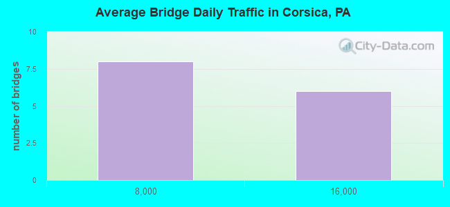
- 81,919Total average daily traffic
- 40,501Total average daily truck traffic
- National Bridge Inventory (NBI) Registered Bridges for Corsica
- No street view available for this location
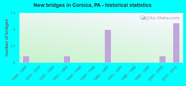
- New bridges - historical statistics
- 11900-1909
- 11930-1939
- 51960-1969
- 12000-2009
- 62010-2019
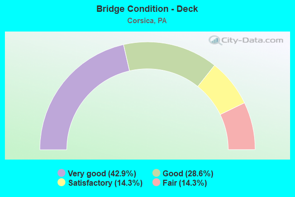
- Bridge Condition - Deck
- 42.9%Very good
- 28.6%Good
- 14.3%Satisfactory
- 14.3%Fair
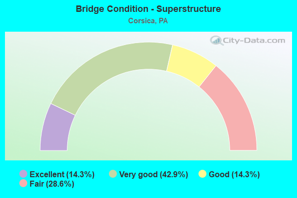
- Bridge Condition - Superstructure
- 14.3%Excellent
- 42.9%Very good
- 14.3%Good
- 28.6%Fair
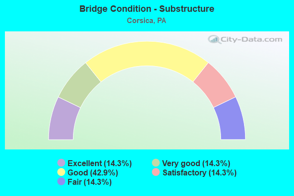
- Bridge Condition - Substructure
- 14.3%Excellent
- 14.3%Very good
- 42.9%Good
- 14.3%Satisfactory
- 14.3%Fair
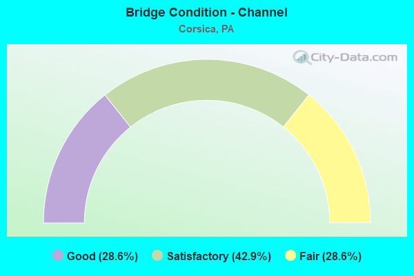
- Bridge Condition - Channel
- 28.6%Good
- 42.9%Satisfactory
- 28.6%Fair
Find on map >> Show street view
Structure Number: 11147, Location: 2.2 mi W, int w/ SR 949 (Lat: 41.204475, Lng: -79.220594), Route carried "on" structure: City street , Year Built: 1960, Status: Temporarily open, Structure Length: 1.01m (3.31ft), Average Daily Traffic: 50 (year 2021), Truck Traffic: 5%, Average Future Daily Traffic: 77 (year 2043), Features Intersected: LITTLE MILL CREEK, Facility Carried by Structure: T-564 WINCKLICK RD
Minimum Vertical Clearance: 30+ m (98+ ft), Kilometerpoint: 0.000, Lanes on structure: 1, Owner: Town or Township Highway Agency, Approaching Roadway Width: 4.0m (13.1ft), Material/Design: Steel, Design/Construction: Stringer/Multi-beam, Number Of Spans In Main Unit: 1, Length of Maximum Span: 9.4m (30.8ft), Curb-To-Curb Width: 3.8m (12.5ft), Out-to-Out Width: 4.0m (13.1ft)
Condition: Deck: Satisfactory, Superstructure: Fair, Substructure: Fair, Channel: Fair, Structural Evaluation: High priority of corrective action, Deck Geometry: Meets minimum limits, Waterway Adequacy: Better than present minimum criteria, Approach Roadway Alignment: Somewhat better than minimum adequacy, Bridge Posting: Required (Relationship of Operating Rating to Maximum Legal Load: > 39.9% below), Length Of Structure Improvement: 1.50m (4.92ft), Designated Inspection Frequency: Every 24 months, Other Special Inspection Frequency: Every 6 months, Inspection Date: September 2021, Other Special Inspection Date: September 2021, Bridge Improvement Cost: $39,000, Roadway Improvement Cost: $250,000, Total Project Cost: $528,000, Deck Structure Type: Concrete Cast-file-Place, Wearing Surface/Protective System: Wearing Surface: Monolithic Concrete
Find on map >> Show street view
Structure Number: 19756, Location: WELCH RUN NO.2 (Lat: 41.159286, Lng: -79.199253), Route carried "on" structure: State highway 949, Year Built: 1936, Status: Open, Structure Length: 0.61m (2.00ft), Average Daily Traffic: 430 (year 2020), Truck Traffic: 4%, Average Future Daily Traffic: 526 (year 2032), Design Load: H 20, Features Intersected: WELCH RUN
Minimum Vertical Clearance: 30+ m (98+ ft), Kilometerpoint: 4.435, Lanes on structure: 2, Owner: State Highway Agency, Approaching Roadway Width: 6.4m (21.0ft), Skew: 4 degrees, Material/Design: Concrete, Design/Construction: Slab, Number Of Spans In Main Unit: 1, Length of Maximum Span: 5.5m (18.0ft), Curb-To-Curb Width: 7.6m (24.9ft), Out-to-Out Width: 8.2m (26.9ft)
Condition: Deck: Fair, Superstructure: Fair, Substructure: Satisfactory, Channel: Fair, Operating Rating: 39.9 metric tons, Method Used To Determine Operating Rating: Load Factor (LF), Inventory Rating: 23.6 metric tons, Method Used To Determine Inventory Rating: Load Factor (LF), Structural Evaluation: Somewhat better than minimum adequacy, Deck Geometry: Meets minimum limits, Waterway Adequacy: Better than present minimum criteria, Approach Roadway Alignment: Better than present minimum criteria, Length Of Structure Improvement: 1.20m (3.94ft), Designated Inspection Frequency: Every 24 months, Inspection Date: July 2021, Bridge Improvement Cost: $8,000, Roadway Improvement Cost: $23,000, Total Project Cost: $106,000, Deck Structure Type: Concrete Cast-file-Place, Wearing Surface/Protective System: Wearing Surface: Bituminous
Find on map >> Show street view
Structure Number: 19824, Location: 2.0 MILES NORTH OF SR 949 (Lat: 41.228233, Lng: -79.185200), Route carried "on" structure: City street 342, Year Built: 1905, Year Reconstructed: 2009, Status: Open, Structure Length: 1.95m (6.40ft), Average Daily Traffic: 50 (year 2021), Truck Traffic: 5%, Average Future Daily Traffic: 70 (year 2041), Design Load: HL 93, Features Intersected: MILL CREEK
Minimum Vertical Clearance: 30+ m (98+ ft), Kilometerpoint: 0.000, Lanes on structure: 1, Owner: County Highway Agency, Approaching Roadway Width: 4.6m (15.1ft), Material/Design: Steel, Design/Construction: Stringer/Multi-beam, Number Of Spans In Main Unit: 1, Length of Maximum Span: 18.9m (62.0ft), Curb-To-Curb Width: 4.7m (15.4ft), Out-to-Out Width: 5.8m (19.0ft)
Condition: Deck: Very good, Superstructure: Very good, Substructure: Very good, Channel: Good, Operating Rating: 83.5 metric tons, Method Used To Determine Operating Rating: Load and Resistance Factor (LRFR), Inventory Rating: 64.4 metric tons, Method Used To Determine Inventory Rating: Load and Resistance Factor (LRFR), Structural Evaluation: Equal to present desirable criteria, Deck Geometry: Better than present minimum criteria, Waterway Adequacy: Equal to present desirable criteria, Approach Roadway Alignment: Meets minimum limits, Length Of Structure Improvement: 2.40m (7.87ft), Designated Inspection Frequency: Every 24 months, Inspection Date: July 2021, Bridge Improvement Cost: $38,000, Roadway Improvement Cost: $111,000, Total Project Cost: $508,000, Deck Structure Type: Concrete Cast-file-Place, Wearing Surface/Protective System: Wearing Surface: Monolithic Concrete, Deck Protection: Other Coated Reinforcing
Find on map >> Show street view
Structure Number: 43457, Location: 2.3 mi SE, int. w/ SR1001 (Lat: 41.234689, Lng: -79.234908), Route carried "on" structure: City street , Year Built: 2004, Status: Open, Structure Length: 2.59m (8.50ft), Average Daily Traffic: 50 (year 2021), Truck Traffic: 10%, Average Future Daily Traffic: 70 (year 2043), Design Load: HS 25 or greater, Features Intersected: MILL CREEK, Facility Carried by Structure: T-562 OLD STATE RD
Minimum Vertical Clearance: 30+ m (98+ ft), Kilometerpoint: 0.000, Lanes on structure: 2, Owner: Town or Township Highway Agency, Approaching Roadway Width: 5.8m (19.0ft), Material/Design: Prestressed concrete, Design/Construction: Box Beam or Girders - Single/Spread, Number Of Spans In Main Unit: 1, Length of Maximum Span: 25.6m (84.0ft), Curb or Sidewalk Widths: Left: 0.2m (0.7ft), Right: 0.2m (0.7ft), Curb-To-Curb Width: 7.8m (25.6ft), Out-to-Out Width: 8.7m (28.5ft)
Condition: Deck: Good, Superstructure: Very good, Substructure: Good, Channel: Satisfactory, Operating Rating: 82.6 metric tons, Method Used To Determine Operating Rating: Load and Resistance Factor (LRFR), Inventory Rating: 41.7 metric tons, Method Used To Determine Inventory Rating: Load and Resistance Factor (LRFR), Structural Evaluation: Better than present minimum criteria, Deck Geometry: Equal to present minimum criteria, Waterway Adequacy: Equal to present desirable criteria, Approach Roadway Alignment: Equal to present desirable criteria, Length Of Structure Improvement: 2.60m (8.53ft), Designated Inspection Frequency: Every 24 months, Inspection Date: September 2021, Deck Structure Type: Concrete Cast-file-Place, Wearing Surface/Protective System: Wearing Surface: Monolithic Concrete, Deck Protection: Epoxy Coated Reinforcing
Find on map >> Show street view
Structure Number: 48083, Location: 1.1 MI SW SR 4001 INTER. (Lat: 41.221236, Lng: -79.161333), Route carried "on" structure: State highway 949, Year Built: 2013, Status: Open, Structure Length: 3.14m (10.30ft), Average Daily Traffic: 666 (year 2022), Truck Traffic: 7%, Average Future Daily Traffic: 419 (year 2032), Design Load: HL 93, Features Intersected: MILL CREEK
Minimum Vertical Clearance: 30+ m (98+ ft), Kilometerpoint: 12.775, Lanes on structure: 2, Owner: State Highway Agency, Approaching Roadway Width: 8.5m (27.9ft), Skew: 1 degrees, Material/Design: Steel continuous, Design/Construction: Stringer/Multi-beam, Number Of Spans In Main Unit: 2, Length of Maximum Span: 15.2m (49.9ft), Curb or Sidewalk Widths: Left: 0.2m (0.7ft), Right: 0.2m (0.7ft), Curb-To-Curb Width: 8.5m (27.9ft), Out-to-Out Width: 9.6m (31.5ft)
Condition: Deck: Good, Superstructure: Very good, Substructure: Good, Channel: Satisfactory, Operating Rating: 47.0 metric tons, Method Used To Determine Operating Rating: Assigned ratings based on Load and Resistance Factor Design (LRFD) reported by rating factor (RF) using HL93 loadings, Inventory Rating: 36.0 metric tons, Method Used To Determine Inventory Rating: Assigned ratings based on Load and Resistance Factor Design (LRFD) reported by rating factor (RF) using HL93 loadings, Structural Evaluation: Better than present minimum criteria, Deck Geometry: Somewhat better than minimum adequacy, Waterway Adequacy: Equal to present desirable criteria, Approach Roadway Alignment: Equal to present desirable criteria, Designated Inspection Frequency: Every 48 months, Inspection Date: August 2019, Deck Structure Type: Concrete Cast-file-Place, Wearing Surface/Protective System: Wearing Surface: Monolithic Concrete, Deck Protection: Epoxy Coated Reinforcing
Find on map >> Show street view
Structure Number: 53503, Location: 0.4 Mi N SR 322 Inter. (Lat: 41.187414, Lng: -79.236442), Route carried "on" structure: State highway , Year Built: 2016, Status: Open, Structure Length: 6.19m (20.31ft), Average Daily Traffic: 186 (year 2022), Truck Traffic: 8%, Average Future Daily Traffic: 242 (year 2032), Design Load: HL 93, Features Intersected: SR 0080 EB & WB, Facility Carried by Structure: SR 2025
Minimum Vertical Clearance: 30+ m (98+ ft), Kilometerpoint: 0.000, Lanes on structure: 2, Lanes under structure: 4, Owner: State Highway Agency, Approaching Roadway Width: 5.8m (19.0ft), Skew: 1 degrees, Material/Design: Steel continuous, Design/Construction: Stringer/Multi-beam, Number Of Spans In Main Unit: 2, Length of Maximum Span: 30.5m (100.1ft), Curb or Sidewalk Widths: Left: 0.2m (0.7ft), Right: 0.2m (0.7ft), Curb-To-Curb Width: 8.5m (27.9ft), Out-to-Out Width: 9.6m (31.5ft)
Condition: Deck: Very good, Superstructure: Good, Substructure: Good, Operating Rating: 48.9 metric tons, Method Used To Determine Operating Rating: Assigned ratings based on Load and Resistance Factor Design (LRFD) reported by rating factor (RF) using HL93 loadings, Inventory Rating: 37.9 metric tons, Method Used To Determine Inventory Rating: Assigned ratings based on Load and Resistance Factor Design (LRFD) reported by rating factor (RF) using HL93 loadings, Structural Evaluation: Better than present minimum criteria, Deck Geometry: Equal to present minimum criteria, Underclear: Equal to present minimum criteria, Approach Roadway Alignment: Equal to present desirable criteria, Designated Inspection Frequency: Every 48 months, Inspection Date: September 2020, Deck Structure Type: Concrete Cast-file-Place, Wearing Surface/Protective System: Wearing Surface: Monolithic Concrete, Deck Protection: Epoxy Coated Reinforcing
Find on map >> Show street view
Structure Number: 53856, Location: NORTH OF ROSEVILLE (Lat: 41.214264, Lng: -79.146875), Route carried "on" structure: State highway , Year Built: 2017, Status: Open, Structure Length: 2.26m (7.41ft), Average Daily Traffic: 135 (year 2021), Truck Traffic: 1%, Average Future Daily Traffic: 376 (year 2037), Design Load: HL 93, Features Intersected: MILL CREEK, Facility Carried by Structure: Roseville Sigel Rd
Minimum Vertical Clearance: 30+ m (98+ ft), Kilometerpoint: 4.144, Lanes on structure: 2, Owner: State Highway Agency, Maintenance Responsibility: Private, Approaching Roadway Width: 6.4m (21.0ft), Material/Design: Prestressed concrete, Design/Construction: Box Beam or Girders - Single/Spread, Number Of Spans In Main Unit: 1, Length of Maximum Span: 21.3m (69.9ft), Curb-To-Curb Width: 7.3m (24.0ft), Out-to-Out Width: 7.9m (25.9ft)
Condition: Deck: Very good, Superstructure: Excellent, Substructure: Excellent, Channel: Satisfactory, Operating Rating: 68.7 metric tons, Method Used To Determine Operating Rating: Assigned ratings based on Load and Resistance Factor Design (LRFD) reported by rating factor (RF) using HL93 loadings, Inventory Rating: 52.8 metric tons, Method Used To Determine Inventory Rating: Assigned ratings based on Load and Resistance Factor Design (LRFD) reported by rating factor (RF) using HL93 loadings, Structural Evaluation: Superior to present desirable criteria, Deck Geometry: Somewhat better than minimum adequacy, Waterway Adequacy: Superior to present desirable criteria, Approach Roadway Alignment: Equal to present desirable criteria, Designated Inspection Frequency: Every 24 months, Inspection Date: August 2021, Deck Structure Type: Concrete Cast-file-Place, Wearing Surface/Protective System: Wearing Surface: Integral Concrete, Deck Protection: Epoxy Coated Reinforcing
Find on map >> Show street view
Structure Number: 57014, Location: 4.6 mi ENE, int w/ US 322 (Lat: 41.201494, Lng: -79.224361), Route carried "on" structure: City street , Year Built: 2019, Status: Open, Structure Length: 0.73m (2.40ft), Average Daily Traffic: 50 (year 2021), Truck Traffic: 1%, Average Future Daily Traffic: 77 (year 2043), Design Load: HS 25 or greater, Features Intersected: LITTLE MILL CREEK, Facility Carried by Structure: T-562 OLD STATE RD
Minimum Vertical Clearance: 30+ m (98+ ft), Kilometerpoint: 0.000, Lanes on structure: 1, Owner: Town or Township Highway Agency, Approaching Roadway Width: 4.0m (13.1ft), Material/Design: Aluminum, Iron, Design/Construction: Culvert, Number Of Spans In Main Unit: 1, Length of Maximum Span: 7.3m (24.0ft)
Condition: Channel: Good, Culverts: Very good, Operating Rating: 64.4 metric tons, Method Used To Determine Operating Rating: Assigned ratings based on Load and Resistance Factor Design (LRFD) reported in metric tons, Inventory Rating: 35.4 metric tons, Method Used To Determine Inventory Rating: Assigned ratings based on Load and Resistance Factor Design (LRFD) reported in metric tons, Structural Evaluation: Equal to present desirable criteria, Waterway Adequacy: Superior to present desirable criteria, Approach Roadway Alignment: Equal to present desirable criteria, Designated Inspection Frequency: Every 24 months, Inspection Date: August 2021
Find on map >> Show street view
Structure Number: 10979, Location: DAY (Lat: 41.182731, Lng: -79.244058), Route carried "under" structure: Interstate 80, Year Built: 1960, Structure Length: 0. m, Average Daily Traffic: 12,859 (year 2021), Truck Traffic: 56%, Features Intersected: SR0080 EB&WB, Facility Carried by Structure: SR0322
Minimum Vertical Clearance: 5.21m (17.09ft), Kilometerpoint: 42.036, Lanes on structure: 2, Lanes under structure: 2, Material/Design: Steel continuous, Design/Construction: Stringer/Multi-beam, Length of Maximum Span: 23.5m (77.1ft)
Find on map >> Show street view
Structure Number: 10979, Location: DAY (Lat: 41.182731, Lng: -79.244058), Route carried "under" structure: Interstate 80, Year Built: 1960, Structure Length: 0. m, Average Daily Traffic: 12,865 (year 2021), Truck Traffic: 54%, Features Intersected: SR0080 EB&WB, Facility Carried by Structure: SR0322
Minimum Vertical Clearance: 5.18m (16.99ft), Kilometerpoint: 42.067, Lanes on structure: 2, Lanes under structure: 2, Material/Design: Steel continuous, Design/Construction: Stringer/Multi-beam, Length of Maximum Span: 23.5m (77.1ft)
Find on map >> Show street view
Structure Number: 19663, Location: CORSICA (Lat: 41.186456, Lng: -79.197675), Route carried "under" structure: Interstate 80, Year Built: 1960, Structure Length: 0. m, Average Daily Traffic: 14,212 (year 2021), Truck Traffic: 42%, Features Intersected: SR0080 EB&WB, Facility Carried by Structure: SR0949
Minimum Vertical Clearance: 4.95m (16.24ft), Kilometerpoint: 0.880, Lanes on structure: 2, Lanes under structure: 2, Material/Design: Steel, Design/Construction: Stringer/Multi-beam, Length of Maximum Span: 20.7m (67.9ft)
Find on map >> Show street view
Structure Number: 19663, Location: CORSICA (Lat: 41.186456, Lng: -79.197675), Route carried "under" structure: Interstate 80, Year Built: 1960, Structure Length: 0. m, Average Daily Traffic: 14,642 (year 2021), Truck Traffic: 42%, Features Intersected: SR0080 EB&WB, Facility Carried by Structure: SR0949
Minimum Vertical Clearance: 5.08m (16.67ft), Kilometerpoint: 0.637, Lanes on structure: 2, Lanes under structure: 2, Material/Design: Steel, Design/Construction: Stringer/Multi-beam, Length of Maximum Span: 20.7m (67.9ft)
Find on map >> Show street view
Structure Number: 53503, Location: 0.4 Mi N SR 322 Inter. (Lat: 41.187414, Lng: -79.236442), Route carried "under" structure: Interstate 80, Year Built: 2016, Structure Length: 0. m, Average Daily Traffic: 12,865 (year 2021), Truck Traffic: 54%, Features Intersected: SR 0080 EB & WB, Facility Carried by Structure: SR 2025
Minimum Vertical Clearance: 5.18m (16.99ft), Kilometerpoint: 42.809, Lanes on structure: 2, Lanes under structure: 2, Material/Design: Steel continuous, Design/Construction: Stringer/Multi-beam, Length of Maximum Span: 30.5m (100.1ft)
Find on map >> Show street view
Structure Number: 53503, Location: 0.4 Mi N SR 322 Inter. (Lat: 41.187414, Lng: -79.236442), Route carried "under" structure: Interstate 80, Year Built: 2016, Structure Length: 0. m, Average Daily Traffic: 12,859 (year 2021), Truck Traffic: 56%, Features Intersected: SR 0080 EB & WB, Facility Carried by Structure: SR 2025
Minimum Vertical Clearance: 5.12m (16.80ft), Kilometerpoint: 42.739, Lanes on structure: 2, Lanes under structure: 2, Material/Design: Steel continuous, Design/Construction: Stringer/Multi-beam, Length of Maximum Span: 30.5m (100.1ft)