Bridge Statistics for Cortlandt, New York (NY)
Condition, Traffic, Stress, Structural Evaluation, Project Costs
- National Bridge Inventory (NBI) Statistics
- 32Number of bridges
- 226ft / 69.0mTotal length
- $73,420,000Total costs
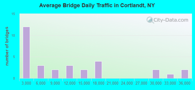
- 329,093Total average daily traffic
- 15,941Total average daily truck traffic
- National Bridge Inventory (NBI) Registered Bridges for Cortlandt
- No street view available for this location
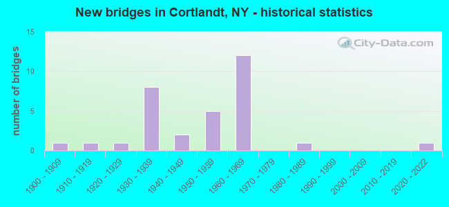
- New bridges - historical statistics
- 11900-1909
- 11910-1919
- 11920-1929
- 81930-1939
- 21940-1949
- 51950-1959
- 121960-1969
- 11980-1989
- 12020-2022
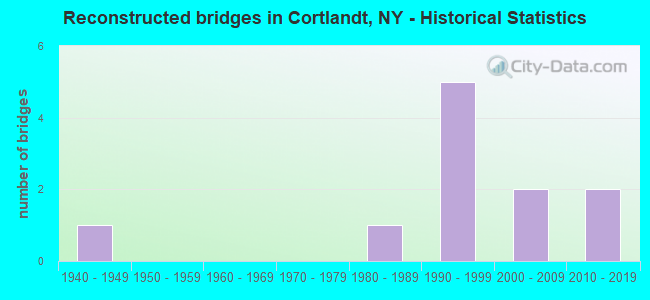
- Reconstructed bridges - Historical Statistics
- 11940-1949
- 01950-1959
- 01960-1969
- 01970-1979
- 11980-1989
- 51990-1999
- 22000-2009
- 22010-2019
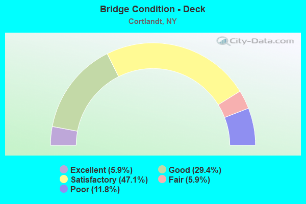
- Bridge Condition - Deck
- 5.9%Excellent
- 29.4%Good
- 47.1%Satisfactory
- 5.9%Fair
- 11.8%Poor
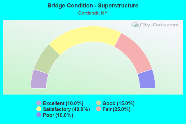
- Bridge Condition - Superstructure
- 10.0%Excellent
- 15.0%Good
- 40.0%Satisfactory
- 25.0%Fair
- 10.0%Poor
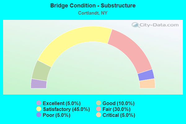
- Bridge Condition - Substructure
- 5.0%Excellent
- 10.0%Good
- 45.0%Satisfactory
- 30.0%Fair
- 5.0%Poor
- 5.0%Critical
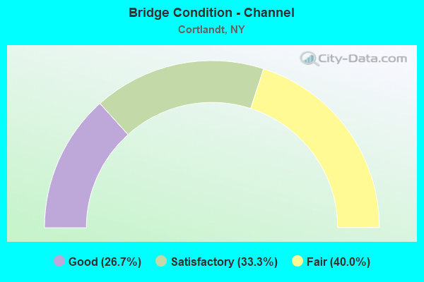
- Bridge Condition - Channel
- 26.7%Good
- 33.3%Satisfactory
- 40.0%Fair
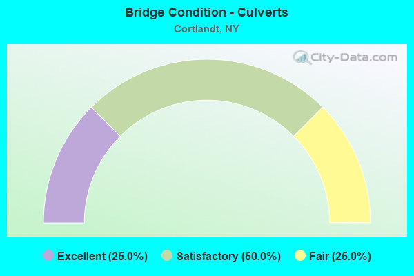
- Bridge Condition - Culverts
- 25.0%Excellent
- 50.0%Satisfactory
- 25.0%Fair
Find on map >> Show street view
Structure Number: 100342, Location: JCT BEAR MTN PKWY & US 6 (Lat: 41.299242, Lng: -73.885694), Route carried "on" structure: State highway 987H, Year Built: 1931, Year Reconstructed: 2001, Status: Open, Structure Length: 2.56m (8.40ft), Average Daily Traffic: 16,405 (year 2010), Truck Traffic: 2%, Average Future Daily Traffic: 23,142 (year 2040), Design Load: HS 20, Features Intersected: RTE 6
Minimum Vertical Clearance: 30+ m (98+ ft), Kilometerpoint: 5.101, Lanes on structure: 2, Lanes under structure: 2, Base Highway Network: Yes, Owner: State Highway Agency, Approaching Roadway Width: 12.8m (42.0ft), Skew: 30 degrees, Material/Design: Concrete, Design/Construction: Frame, Number Of Spans In Main Unit: 1, Length of Maximum Span: 18.2m (59.7ft), Curb or Sidewalk Widths: Left: 0.5m (1.6ft), Right: 0.6m (2.0ft), Curb-To-Curb Width: 12.9m (42.3ft), Out-to-Out Width: 15.1m (49.5ft)
Condition: Superstructure: Satisfactory, Substructure: Satisfactory, Operating Rating: 85.6 metric tons, Method Used To Determine Operating Rating: Field evaluation and documented engineering judgment, Inventory Rating: 32.7 metric tons, Method Used To Determine Inventory Rating: Field evaluation and documented engineering judgment, Structural Evaluation: Equal to present minimum criteria, Deck Geometry: Somewhat better than minimum adequacy, Underclear: High priority of corrective action, Approach Roadway Alignment: Meets minimum limits, Length Of Structure Improvement: 2.56m (8.40ft), Designated Inspection Frequency: Every 24 months, Inspection Date: May 2020, Bridge Improvement Cost: $3,094,000, Roadway Improvement Cost: $1,812,000, Total Project Cost: $4,906,000 ( Estimate for 2021), Wearing Surface/Protective System: Wearing Surface: Bituminous
Find on map >> Show street view
Structure Number: 100503, Location: 2.5 MI N JCT RTS 9+129 (Lat: 41.228775, Lng: -73.911650), Route carried "on" structure: US 9, Year Built: 1964, Status: Open, Structure Length: 1.37m (4.49ft), Average Daily Traffic: 35,965 (year 2020), Truck Traffic: 7%, Average Future Daily Traffic: 50,735 (year 2040), Design Load: HS 20, Features Intersected: FURNACE DOCK ROAD
Minimum Vertical Clearance: 30+ m (98+ ft), Kilometerpoint: 38.407, Lanes on structure: 6, Lanes under structure: 2, Base Highway Network: Yes, Owner: State Highway Agency, Approaching Roadway Width: 35.4m (116.1ft), Skew: 31 degrees, Material/Design: Concrete, Design/Construction: Frame, Number Of Spans In Main Unit: 1, Length of Maximum Span: 11.0m (36.1ft), Curb-To-Curb Width: 35.3m (115.8ft), Out-to-Out Width: 36.8m (120.7ft)
Condition: Superstructure: Satisfactory, Substructure: Satisfactory, Operating Rating: 80.4 metric tons, Method Used To Determine Operating Rating: Field evaluation and documented engineering judgment, Inventory Rating: 32.7 metric tons, Method Used To Determine Inventory Rating: Field evaluation and documented engineering judgment, Structural Evaluation: Equal to present minimum criteria, Deck Geometry: Superior to present desirable criteria, Underclear: High priority of corrective action, Approach Roadway Alignment: Equal to present desirable criteria, Length Of Structure Improvement: 1.37m (4.49ft), Designated Inspection Frequency: Every 24 months, Inspection Date: October 2020, Bridge Improvement Cost: $3,638,000, Roadway Improvement Cost: $2,130,000, Total Project Cost: $5,768,000 ( Estimate for 2021)
Find on map >> Show street view
Structure Number: 100504, Location: 2.5 MI N JCT RTS 9+129 (Lat: 41.229372, Lng: -73.911572), Route carried "on" structure: US 9, Year Built: 1964, Year Reconstructed: 2017, Status: Open, Structure Length: 1.31m (4.30ft), Average Daily Traffic: 35,965 (year 2020), Truck Traffic: 7%, Average Future Daily Traffic: 50,735 (year 2040), Design Load: HS 20, Features Intersected: FURNACE BROOK
Minimum Vertical Clearance: 30+ m (98+ ft), Kilometerpoint: 38.471, Lanes on structure: 6, Base Highway Network: Yes, Owner: State Highway Agency, Approaching Roadway Width: 33.5m (109.9ft), Skew: 30 degrees, Material/Design: Concrete, Design/Construction: Culvert, Number Of Spans In Main Unit: 3, Length of Maximum Span: 3.6m (11.8ft)
Condition: Channel: Satisfactory, Culverts: Satisfactory, Operating Rating: 75.1 metric tons, Method Used To Determine Operating Rating: Field evaluation and documented engineering judgment, Inventory Rating: 32.7 metric tons, Method Used To Determine Inventory Rating: Field evaluation and documented engineering judgment, Structural Evaluation: Equal to present minimum criteria, Waterway Adequacy: Meets minimum limits, Approach Roadway Alignment: Equal to present desirable criteria, Length Of Structure Improvement: 1.31m (4.30ft), Designated Inspection Frequency: Every 24 months, Inspection Date: November 2020, Bridge Improvement Cost: $1,238,000, Roadway Improvement Cost: $725,000, Total Project Cost: $1,963,000 ( Estimate for 2021)
Find on map >> Show street view
Structure Number: 1005051, Location: 5.5 MI N JCT RTS 9+129 (Lat: 41.231208, Lng: -73.911472), Route carried "on" structure: US 9, Year Built: 1964, Status: Open, Structure Length: 5.27m (17.29ft), Average Daily Traffic: 17,983 (year 2020), Truck Traffic: 7%, Average Future Daily Traffic: 25,368 (year 2040), Design Load: HS 20, Features Intersected: RTE 9A
Minimum Vertical Clearance: 30+ m (98+ ft), Kilometerpoint: 38.664, Lanes on structure: 2, Lanes under structure: 4, Base Highway Network: Yes, Owner: State Highway Agency, Approaching Roadway Width: 11.6m (38.1ft), Skew: 1 degrees, Material/Design: Steel, Design/Construction: Stringer/Multi-beam, Number Of Spans In Main Unit: 3, Length of Maximum Span: 24.0m (78.7ft), Curb-To-Curb Width: 9.8m (32.2ft), Out-to-Out Width: 10.6m (34.8ft)
Condition: Deck: Satisfactory, Superstructure: Fair, Substructure: Fair, Operating Rating: 62.2 metric tons, Method Used To Determine Operating Rating: Load and Resistance Factor Rating (LRFR) rating reported by rating factor(RF) method using HL-93 loadings, Inventory Rating: 48.0 metric tons, Method Used To Determine Inventory Rating: Load and Resistance Factor Rating (LRFR) rating reported by rating factor(RF) method using HL-93 loadings, Structural Evaluation: Somewhat better than minimum adequacy, Deck Geometry: High priority of replacement, Underclear: Meets minimum limits, Approach Roadway Alignment: Equal to present desirable criteria, Length Of Structure Improvement: 5.27m (17.29ft), Designated Inspection Frequency: Every 24 months, Inspection Date: August 2020, Bridge Improvement Cost: $2,187,000, Roadway Improvement Cost: $1,281,000, Total Project Cost: $3,467,000 ( Estimate for 2021), Deck Structure Type: Concrete Cast-file-Place, Wearing Surface/Protective System: Wearing Surface: Bituminous, Membrane: Other
Find on map >> Show street view
Structure Number: 1005052, Location: 5.5 MI N JCT RTS 9+129 (Lat: 41.231186, Lng: -73.911297), Route carried "on" structure: US 9, Year Built: 1964, Status: Open, Structure Length: 5.30m (17.39ft), Average Daily Traffic: 17,983 (year 2020), Truck Traffic: 7%, Average Future Daily Traffic: 25,368 (year 2040), Design Load: HS 20+Mod, Features Intersected: RTE 9A
Minimum Vertical Clearance: 30+ m (98+ ft), Kilometerpoint: 38.648, Lanes on structure: 2, Lanes under structure: 4, Base Highway Network: Yes, Owner: State Highway Agency, Approaching Roadway Width: 11.6m (38.1ft), Skew: 1 degrees, Material/Design: Steel, Design/Construction: Stringer/Multi-beam, Number Of Spans In Main Unit: 3, Length of Maximum Span: 24.0m (78.7ft), Curb-To-Curb Width: 9.8m (32.2ft), Out-to-Out Width: 10.4m (34.1ft)
Condition: Deck: Satisfactory, Superstructure: Fair, Substructure: Fair, Operating Rating: 63.2 metric tons, Method Used To Determine Operating Rating: Load and Resistance Factor Rating (LRFR) rating reported by rating factor(RF) method using HL-93 loadings, Inventory Rating: 48.6 metric tons, Method Used To Determine Inventory Rating: Load and Resistance Factor Rating (LRFR) rating reported by rating factor(RF) method using HL-93 loadings, Structural Evaluation: Somewhat better than minimum adequacy, Deck Geometry: High priority of replacement, Underclear: Meets minimum limits, Approach Roadway Alignment: Equal to present desirable criteria, Length Of Structure Improvement: 5.30m (17.39ft), Designated Inspection Frequency: Every 24 months, Inspection Date: August 2020, Bridge Improvement Cost: $2,160,000, Roadway Improvement Cost: $1,265,000, Total Project Cost: $3,425,000 ( Estimate for 2021), Deck Structure Type: Concrete Cast-file-Place, Wearing Surface/Protective System: Wearing Surface: Bituminous, Membrane: Other
Find on map >> Show street view
Structure Number: 100506, Location: 5.9 MI N JCT RTS 9+129 (Lat: 41.236239, Lng: -73.913008), Route carried "on" structure: Other road , Year Built: 1964, Status: Open, Structure Length: 4.51m (14.80ft), Average Daily Traffic: 3,850 (year 2017), Truck Traffic: 3%, Average Future Daily Traffic: 5,390 (year 2037), Design Load: H 20, Features Intersected: 9 9 87032196 SB, RTE 9, Facility Carried by Structure: WATCH HILL ROAD
Minimum Vertical Clearance: 30+ m (98+ ft), Kilometerpoint: 0.145, Lanes on structure: 2, Lanes under structure: 4, Owner: State Highway Agency, Approaching Roadway Width: 9.8m (32.2ft), Material/Design: Steel, Design/Construction: Stringer/Multi-beam, Number Of Spans In Main Unit: 2, Length of Maximum Span: 23.5m (77.1ft), Curb-To-Curb Width: 9.2m (30.2ft), Out-to-Out Width: 10.5m (34.4ft)
Condition: Deck: Satisfactory, Superstructure: Satisfactory, Substructure: Satisfactory, Operating Rating: 81.6 metric tons, Method Used To Determine Operating Rating: Load Factor (LF), Inventory Rating: 49.0 metric tons, Method Used To Determine Inventory Rating: Load Factor (LF), Structural Evaluation: Equal to present minimum criteria, Deck Geometry: Meets minimum limits, Underclear: Meets minimum limits, Approach Roadway Alignment: Equal to present desirable criteria, Length Of Structure Improvement: 4.51m (14.80ft), Designated Inspection Frequency: Every 24 months, Inspection Date: April 2021, Bridge Improvement Cost: $2,068,000, Roadway Improvement Cost: $1,211,000, Total Project Cost: $3,279,000 ( Estimate for 2021), Deck Structure Type: Concrete Cast-file-Place, Wearing Surface/Protective System: Wearing Surface: Bituminous, Membrane: Other
Find on map >> Show street view
Structure Number: 1005079, Location: IN MONTROSE (Lat: 41.253431, Lng: -73.927822), Route carried "on" structure: US 9, Year Built: 1964, Status: Open, Structure Length: 1.37m (4.49ft), Average Daily Traffic: 29,895 (year 2020), Truck Traffic: 7%, Average Future Daily Traffic: 42,172 (year 2040), Design Load: HS 20, Features Intersected: MONTROSE STA ROAD
Minimum Vertical Clearance: 30+ m (98+ ft), Kilometerpoint: 41.560, Lanes on structure: 4, Lanes under structure: 2, Base Highway Network: Yes, Owner: State Highway Agency, Approaching Roadway Width: 28.0m (91.9ft), Skew: 32 degrees, Material/Design: Concrete, Design/Construction: Frame, Number Of Spans In Main Unit: 1, Length of Maximum Span: 10.9m (35.8ft), Curb-To-Curb Width: 28.0m (91.9ft), Out-to-Out Width: 29.6m (97.1ft)
Condition: Superstructure: Satisfactory, Substructure: Satisfactory, Operating Rating: 80.4 metric tons, Method Used To Determine Operating Rating: Field evaluation and documented engineering judgment, Inventory Rating: 32.7 metric tons, Method Used To Determine Inventory Rating: Field evaluation and documented engineering judgment, Structural Evaluation: Equal to present minimum criteria, Deck Geometry: Superior to present desirable criteria, Underclear: High priority of corrective action, Approach Roadway Alignment: Equal to present desirable criteria, Length Of Structure Improvement: 1.37m (4.49ft), Designated Inspection Frequency: Every 24 months, Inspection Date: November 2020, Bridge Improvement Cost: $3,100,000, Roadway Improvement Cost: $1,815,000, Total Project Cost: $4,915,000 ( Estimate for 2021)
Find on map >> Show street view
Structure Number: 100508, Location: 8.5 MI N JCT RTS 9+129 (Lat: 41.268342, Lng: -73.934414), Route carried "on" structure: US 9, Year Built: 1964, Year Reconstructed: 2017, Status: Open, Structure Length: 0.61m (2.00ft), Average Daily Traffic: 29,895 (year 2020), Truck Traffic: 7%, Average Future Daily Traffic: 42,172 (year 2040), Design Load: H 20, Features Intersected: DICKEY BROOK
Minimum Vertical Clearance: 30+ m (98+ ft), Kilometerpoint: 43.298, Lanes on structure: 5, Base Highway Network: Yes, Owner: State Highway Agency, Approaching Roadway Width: 30.5m (100.1ft), Skew: 20 degrees, Material/Design: Steel, Design/Construction: Culvert, Number Of Spans In Main Unit: 2, Length of Maximum Span: 2.4m (7.9ft)
Condition: Channel: Good, Culverts: Excellent, Operating Rating: 71.8 metric tons, Method Used To Determine Operating Rating: Field evaluation and documented engineering judgment, Inventory Rating: 32.7 metric tons, Method Used To Determine Inventory Rating: Field evaluation and documented engineering judgment, Structural Evaluation: Superior to present desirable criteria, Waterway Adequacy: Meets minimum limits, Approach Roadway Alignment: Equal to present desirable criteria, Length Of Structure Improvement: 0.60m (1.97ft), Designated Inspection Frequency: Every 24 months, Inspection Date: April 2021, Bridge Improvement Cost: $523,000, Roadway Improvement Cost: $307,000, Total Project Cost: $830,000 ( Estimate for 2021)
Find on map >> Show street view
Structure Number: 100515, Location: 1.4 MI S WESTCH-PUTNAM CL (Lat: 41.308531, Lng: -73.930694), Route carried "on" structure: US 9, Year Built: 1950, Year Reconstructed: 2013, Status: Open, Structure Length: 8.66m (28.41ft), Average Daily Traffic: 12,576 (year 2018), Truck Traffic: 6%, Average Future Daily Traffic: 12,635 (year 2040), Design Load: H 20, Features Intersected: COUNTY RTE 306, ANNSVILL
Minimum Vertical Clearance: 30+ m (98+ ft), Kilometerpoint: 48.350, Lanes on structure: 2, Lanes under structure: 2, Base Highway Network: Yes, Owner: State Highway Agency, Approaching Roadway Width: 8.2m (26.9ft), Skew: 4 degrees, Material/Design: Steel, Design/Construction: Stringer/Multi-beam, Number Of Spans In Main Unit: 4, Length of Maximum Span: 24.4m (80.1ft), Curb-To-Curb Width: 8.5m (27.9ft), Out-to-Out Width: 9.8m (32.2ft)
Condition: Deck: Good, Superstructure: Satisfactory, Substructure: Fair, Channel: Satisfactory, Operating Rating: 57.2 metric tons, Method Used To Determine Operating Rating: Load Factor (LF), Inventory Rating: 34.5 metric tons, Method Used To Determine Inventory Rating: Load Factor (LF), Structural Evaluation: Somewhat better than minimum adequacy, Deck Geometry: High priority of corrective action, Underclear: Meets minimum limits, Waterway Adequacy: Meets minimum limits, Approach Roadway Alignment: Meets minimum limits, Length Of Structure Improvement: 8.65m (28.38ft), Designated Inspection Frequency: Every 24 months, Inspection Date: November 2021, Bridge Improvement Cost: $4,078,000, Roadway Improvement Cost: $2,388,000, Total Project Cost: $6,466,000 ( Estimate for 2021), Deck Structure Type: Concrete Cast-file-Place, Wearing Surface/Protective System: Wearing Surface: Integral Concrete, Deck Protection: Epoxy Coated Reinforcing
Find on map >> Show street view
Structure Number: 100516, Location: 1 MI S OF WEST- PUTNAM CL (Lat: 41.313422, Lng: -73.929483), Route carried "on" structure: US 9, Year Built: 1950, Status: Open, Structure Length: 0.91m (2.99ft), Average Daily Traffic: 12,576 (year 2018), Truck Traffic: 6%, Average Future Daily Traffic: 12,635 (year 2040), Design Load: HS 20, Features Intersected: ANNSVILLE CREEK
Minimum Vertical Clearance: 30+ m (98+ ft), Kilometerpoint: 48.962, Lanes on structure: 1, Base Highway Network: Yes, Owner: State Highway Agency, Approaching Roadway Width: 8.5m (27.9ft), Skew: 4 degrees, Material/Design: Concrete, Design/Construction: Frame, Number Of Spans In Main Unit: 1, Length of Maximum Span: 8.2m (26.9ft), Curb-To-Curb Width: 8.5m (27.9ft), Out-to-Out Width: 9.8m (32.2ft)
Condition: Deck: Good, Superstructure: Good, Substructure: Good, Channel: Fair, Operating Rating: 78.4 metric tons, Method Used To Determine Operating Rating: Field evaluation and documented engineering judgment, Inventory Rating: 32.7 metric tons, Method Used To Determine Inventory Rating: Field evaluation and documented engineering judgment, Structural Evaluation: Better than present minimum criteria, Deck Geometry: High priority of replacement, Waterway Adequacy: Meets minimum limits, Approach Roadway Alignment: Meets minimum limits, Length Of Structure Improvement: 0.91m (2.99ft), Designated Inspection Frequency: Every 24 months, Inspection Date: May 2020, Bridge Improvement Cost: $825,000, Roadway Improvement Cost: $483,000, Total Project Cost: $1,308,000 ( Estimate for 2021), Wearing Surface/Protective System: Wearing Surface: Bituminous, Membrane: Other
Find on map >> Show street view
Structure Number: 100624, Location: 3.7 MI N JCT RTS 9A+129 (Lat: 41.239853, Lng: -73.922142), Route carried "on" structure: State highway 9A, Year Built: 1935, Year Reconstructed: 1990, Status: Open, Structure Length: 4.51m (14.80ft), Average Daily Traffic: 10,905 (year 2015), Truck Traffic: 6%, Average Future Daily Traffic: 13,247 (year 2040), Design Load: HS 20, Features Intersected: MNRR HU LINE
Minimum Vertical Clearance: 30+ m (98+ ft), Kilometerpoint: 46.082, Lanes on structure: 3, Base Highway Network: Yes, Owner: State Highway Agency, Approaching Roadway Width: 13.4m (44.0ft), Material/Design: Steel, Design/Construction: Girder and Floorbeam System, Number Of Spans In Main Unit: 1, Number Of Approach Spans: 2, Length of Maximum Span: 25.3m (83.0ft), Curb or Sidewalk Widths: Left: 0.0m, Right: 1.5m (4.9ft), Curb-To-Curb Width: 13.4m (44.0ft), Out-to-Out Width: 16.6m (54.5ft)
Condition: Deck: Fair, Superstructure: Fair, Substructure: Satisfactory, Operating Rating: 40.2 metric tons, Method Used To Determine Operating Rating: Load and Resistance Factor Rating (LRFR) rating reported by rating factor(RF) method using HL-93 loadings, Inventory Rating: 31.1 metric tons, Method Used To Determine Inventory Rating: Load and Resistance Factor Rating (LRFR) rating reported by rating factor(RF) method using HL-93 loadings, Structural Evaluation: Somewhat better than minimum adequacy, Deck Geometry: Somewhat better than minimum adequacy, Underclear: Meets minimum limits, Approach Roadway Alignment: Equal to present desirable criteria, Length Of Structure Improvement: 4.51m (14.80ft), Designated Inspection Frequency: Every 24 months, Critical Feature Inspection Frequency: Every 24 months, Inspection Date: October 2020, Critical Feature Inspection Date: October 2020, Bridge Improvement Cost: $3,394,000, Roadway Improvement Cost: $1,987,000, Total Project Cost: $5,381,000 ( Estimate for 2021), Deck Structure Type: Concrete Cast-file-Place, Wearing Surface/Protective System: Wearing Surface: Bituminous, Deck Protection: Epoxy Coated Reinforcing
Find on map >> Show street view
Structure Number: 105046, Location: .2 MI E US209/ANNSVILLE (Lat: 41.307222, Lng: -73.927161), Route carried "on" structure: Other road , Year Built: 2021, Status: Open, Structure Length: 2.26m (7.41ft), Average Daily Traffic: 7,785 (year 2018), Truck Traffic: 6%, Average Future Daily Traffic: 9,457 (year 2040), Design Load: HL 93, Features Intersected: CANOPUS (SPRT) BRK., Facility Carried by Structure: COUNTY ROAD 306
Minimum Vertical Clearance: 32.69m (107.25ft), Kilometerpoint: 0.434, Lanes on structure: 2, Owner: County Highway Agency, Approaching Roadway Width: 15.2m (49.9ft), Material/Design: Prestressed concrete, Design/Construction: Box Beam or Girders - Multiple, Number Of Spans In Main Unit: 1, Length of Maximum Span: 22.6m (74.1ft), Curb or Sidewalk Widths: Left: 1.5m (4.9ft), Right: 0.0m, Curb-To-Curb Width: 12.2m (40.0ft), Out-to-Out Width: 16.2m (53.1ft)
Condition: Deck: Excellent, Superstructure: Excellent, Substructure: Excellent, Channel: Fair, Operating Rating: 78.9 metric tons, Method Used To Determine Operating Rating: Load Factor (LF), Inventory Rating: 36.3 metric tons, Method Used To Determine Inventory Rating: Load Factor (LF), Structural Evaluation: Superior to present desirable criteria, Deck Geometry: Somewhat better than minimum adequacy, Waterway Adequacy: Meets minimum limits, Approach Roadway Alignment: Equal to present desirable criteria, Designated Inspection Frequency: Every 24 months, Inspection Date: December 2021, Deck Structure Type: Concrete Cast-file-Place, Wearing Surface/Protective System: Deck Protection: Epoxy Coated Reinforcing
Find on map >> Show street view
Structure Number: 105047, Location: 1.6 MI S JCT RTS 9+PUT CL (Lat: 41.308481, Lng: -73.930592), Route carried "on" structure: County highway , Year Built: 1927, Year Reconstructed: 2002, Status: Open, Structure Length: 1.04m (3.41ft), Average Daily Traffic: 7,785 (year 2018), Truck Traffic: 6%, Average Future Daily Traffic: 9,457 (year 2040), Design Load: HS 25 or greater, Features Intersected: ANNSVILLE CREEK, Facility Carried by Structure: COUNTY ROAD 306
Minimum Vertical Clearance: 30+ m (98+ ft), Kilometerpoint: 0.129, Lanes on structure: 2, Owner: County Highway Agency, Approaching Roadway Width: 10.1m (33.1ft), Skew: 6 degrees, Material/Design: Prestressed concrete, Design/Construction: Box Beam or Girders - Multiple, Number Of Spans In Main Unit: 1, Length of Maximum Span: 10.0m (32.8ft), Curb-To-Curb Width: 17.2m (56.4ft), Out-to-Out Width: 17.8m (58.4ft)
Condition: Deck: Good, Superstructure: Good, Substructure: Critical, Channel: Fair, Operating Rating: 97.2 metric tons, Method Used To Determine Operating Rating: Load and Resistance Factor Rating (LRFR) rating reported by rating factor(RF) method using HL-93 loadings, Inventory Rating: 91.4 metric tons, Method Used To Determine Inventory Rating: Load and Resistance Factor Rating (LRFR) rating reported by rating factor(RF) method using HL-93 loadings, Structural Evaluation: High priority of replacement, Deck Geometry: Superior to present desirable criteria, Waterway Adequacy: Equal to present desirable criteria, Approach Roadway Alignment: Meets minimum limits, Length Of Structure Improvement: 1.03m (3.38ft), Designated Inspection Frequency: Every 24 months, Inspection Date: March 2021, Bridge Improvement Cost: $995,000, Roadway Improvement Cost: $583,000, Total Project Cost: $1,578,000 ( Estimate for 2021), Wearing Surface/Protective System: Wearing Surface: Bituminous, Membrane: Other
Find on map >> Show street view
Structure Number: 226233, Location: 2.5 MI N CROTON ON HUDSON (Lat: 41.239892, Lng: -73.898264), Route carried "on" structure: Other road , Year Built: 1983, Status: Open, Structure Length: 1.07m (3.51ft), Average Daily Traffic: 1,351 (year 2019), Truck Traffic: 3%, Average Future Daily Traffic: 1,641 (year 2040), Design Load: HS 20, Features Intersected: FURNACE BROOK, Facility Carried by Structure: WASHINGTON STREET
Minimum Vertical Clearance: 30+ m (98+ ft), Kilometerpoint: 0.032, Lanes on structure: 2, Owner: Town or Township Highway Agency, Approaching Roadway Width: 7.3m (24.0ft), Material/Design: Steel, Design/Construction: Truss - Thru, Number Of Spans In Main Unit: 1, Length of Maximum Span: 9.1m (29.9ft), Curb-To-Curb Width: 7.3m (24.0ft), Out-to-Out Width: 9.3m (30.5ft)
Condition: Deck: Satisfactory, Superstructure: Fair, Substructure: Fair, Channel: Fair, Operating Rating: 79.1 metric tons, Method Used To Determine Operating Rating: Field evaluation and documented engineering judgment, Inventory Rating: 32.7 metric tons, Method Used To Determine Inventory Rating: Field evaluation and documented engineering judgment, Structural Evaluation: Somewhat better than minimum adequacy, Deck Geometry: Meets minimum limits, Waterway Adequacy: Meets minimum limits, Approach Roadway Alignment: Better than present minimum criteria, Length Of Structure Improvement: 1.06m (3.48ft), Designated Inspection Frequency: Every 24 months, Inspection Date: April 2020, Bridge Improvement Cost: $917,000, Roadway Improvement Cost: $537,000, Total Project Cost: $1,455,000 ( Estimate for 2021), Deck Structure Type: Open Grating, Wearing Surface/Protective System: Wearing Surface: Other
Find on map >> Show street view
Structure Number: 226242, Location: 2.7 MILES N OF PEEKSKILL (Lat: 41.325353, Lng: -73.914011), Route carried "on" structure: Other road , Year Built: 1956, Year Reconstructed: 2002, Status: Open, Structure Length: 1.46m (4.79ft), Average Daily Traffic: 607 (year 2016), Truck Traffic: 4%, Average Future Daily Traffic: 850 (year 2036), Features Intersected: CORTLANDT LAKE CK, Facility Carried by Structure: HIGHLAND DRIVE
Minimum Vertical Clearance: 30+ m (98+ ft), Kilometerpoint: 0.177, Lanes on structure: 2, Owner: Town or Township Highway Agency, Approaching Roadway Width: 7.6m (24.9ft), Skew: 4 degrees, Material/Design: Steel, Design/Construction: Culvert, Number Of Spans In Main Unit: 2, Length of Maximum Span: 6.4m (21.0ft)
Condition: Channel: Good, Culverts: Fair, Operating Rating: 74.4 metric tons, Method Used To Determine Operating Rating: Field evaluation and documented engineering judgment, Inventory Rating: 13.1 metric tons, Method Used To Determine Inventory Rating: Field evaluation and documented engineering judgment, Structural Evaluation: Meets minimum limits, Waterway Adequacy: Somewhat better than minimum adequacy, Approach Roadway Alignment: Better than present minimum criteria, Length Of Structure Improvement: 1.46m (4.79ft), Designated Inspection Frequency: Every 12 months, Inspection Date: March 2021, Bridge Improvement Cost: $314,000, Roadway Improvement Cost: $184,000, Total Project Cost: $498,000 ( Estimate for 2021)
Find on map >> Show street view
Structure Number: 226551, Location: 1.5 MI NE CROTON ON HUD. (Lat: 41.227608, Lng: -73.857067), Route carried "on" structure: Other road , Year Built: 1904, Year Reconstructed: 2004, Status: Posted for load, Structure Length: 6.52m (21.39ft), Average Daily Traffic: 8 (year 2018), Average Future Daily Traffic: 11 (year 2038), Design Load: HS 20, Features Intersected: CROTON RES OUTLET, Facility Carried by Structure: CROTON DAM ROAD
Minimum Vertical Clearance: 30+ m (98+ ft), Kilometerpoint: 0.338, Lanes on structure: 2, Owner: Local Agency, Approaching Roadway Width: 6.1m (20.0ft), Design/Construction: Arch - Deck, Number Of Spans In Main Unit: 1, Length of Maximum Span: 61.0m (200.1ft), Curb-To-Curb Width: 6.2m (20.3ft), Out-to-Out Width: 7.2m (23.6ft)
Condition: Deck: Good, Superstructure: Excellent, Substructure: Good, Channel: Good, Operating Rating: 63.5 metric tons, Method Used To Determine Operating Rating: Load Factor (LF), Inventory Rating: 37.2 metric tons, Method Used To Determine Inventory Rating: Load Factor (LF), Structural Evaluation: Better than present minimum criteria, Deck Geometry: Somewhat better than minimum adequacy, Waterway Adequacy: Equal to present minimum criteria, Approach Roadway Alignment: High priority of corrective action, Bridge Posting: Required (Relationship of Operating Rating to Maximum Legal Load: > 39.9% below), Length Of Structure Improvement: 6.52m (21.39ft), Designated Inspection Frequency: Every 12 months, Critical Feature Inspection Frequency: Every 12 months, Inspection Date: November 2021, Critical Feature Inspection Date: November 2021, Bridge Improvement Cost: $4,237,000, Roadway Improvement Cost: $2,481,000, Total Project Cost: $6,718,000 ( Estimate for 2021), Deck Structure Type: Concrete Cast-file-Place, Wearing Surface/Protective System: Wearing Surface: Integral Concrete
Find on map >> Show street view
Structure Number: 226588, Location: 3 MILES S OF PEEKSKILL (Lat: 41.258069, Lng: -73.887422), Route carried "on" structure: Other road , Year Built: 1950, Status: Open, Structure Length: 0.88m (2.89ft), Average Daily Traffic: 2,882 (year 2015), Truck Traffic: 4%, Average Future Daily Traffic: 3,565 (year 2040), Features Intersected: TRIB FURNACE BRK, Facility Carried by Structure: WATCH HILL ROAD
Minimum Vertical Clearance: 30+ m (98+ ft), Kilometerpoint: 3.669, Lanes on structure: 2, Owner: Town or Township Highway Agency, Approaching Roadway Width: 7.3m (24.0ft), Material/Design: Steel, Design/Construction: Culvert, Number Of Spans In Main Unit: 2, Length of Maximum Span: 3.6m (11.8ft), Curb or Sidewalk Widths: Left: 0.0m, Right: 1.8m (5.9ft), Curb-To-Curb Width: 8.1m (26.6ft), Out-to-Out Width: 10.5m (34.4ft)
Condition: Channel: Fair, Culverts: Satisfactory, Operating Rating: 72.3 metric tons, Method Used To Determine Operating Rating: Field evaluation and documented engineering judgment, Inventory Rating: 29.4 metric tons, Method Used To Determine Inventory Rating: Field evaluation and documented engineering judgment, Structural Evaluation: Equal to present minimum criteria, Deck Geometry: High priority of corrective action, Waterway Adequacy: Meets minimum limits, Approach Roadway Alignment: Better than present minimum criteria, Length Of Structure Improvement: 0.88m (2.89ft), Designated Inspection Frequency: Every 24 months, Inspection Date: April 2021, Bridge Improvement Cost: $262,000, Roadway Improvement Cost: $153,000, Total Project Cost: $415,000 ( Estimate for 2021)
Find on map >> Show street view
Structure Number: 334842, Location: 2.3 MI NE OF PEEKSKILL (Lat: 41.317814, Lng: -73.905322), Route carried "on" structure: Other road , Year Built: 1939, Status: Open, Structure Length: 3.41m (11.19ft), Average Daily Traffic: 3,443 (year 2017), Truck Traffic: 4%, Average Future Daily Traffic: 4,260 (year 2040), Features Intersected: PEEKSKILL HOLLOW CK, Facility Carried by Structure: GALLOWS HILL ROAD
Minimum Vertical Clearance: 30+ m (98+ ft), Kilometerpoint: 0.563, Lanes on structure: 2, Owner: County Highway Agency, Approaching Roadway Width: 7.3m (24.0ft), Skew: 4 degrees, Material/Design: Steel, Design/Construction: Stringer/Multi-beam, Number Of Spans In Main Unit: 2, Length of Maximum Span: 23.4m (76.8ft), Curb or Sidewalk Widths: Left: 0.6m (2.0ft), Right: 1.3m (4.3ft), Curb-To-Curb Width: 6.6m (21.7ft), Out-to-Out Width: 8.9m (29.2ft)
Condition: Deck: Satisfactory, Superstructure: Fair, Substructure: Satisfactory, Channel: Good, Operating Rating: 20.1 metric tons, Method Used To Determine Operating Rating: Load and Resistance Factor Rating (LRFR) rating reported by rating factor(RF) method using HL-93 loadings, Inventory Rating: 15.6 metric tons, Method Used To Determine Inventory Rating: Load and Resistance Factor Rating (LRFR) rating reported by rating factor(RF) method using HL-93 loadings, Structural Evaluation: Meets minimum limits, Deck Geometry: High priority of replacement, Waterway Adequacy: Somewhat better than minimum adequacy, Approach Roadway Alignment: Equal to present minimum criteria, Length Of Structure Improvement: 3.41m (11.19ft), Designated Inspection Frequency: Every 24 months, Inspection Date: April 2021, Bridge Improvement Cost: $1,644,000, Roadway Improvement Cost: $963,000, Total Project Cost: $2,607,000 ( Estimate for 2021), Deck Structure Type: Concrete Cast-file-Place, Wearing Surface/Protective System: Wearing Surface: Bituminous
Find on map >> Show street view
Structure Number: 334843, Location: 2.0 MI NE OF PEEKSKILL (Lat: 41.314253, Lng: -73.908742), Route carried "on" structure: Other road , Year Built: 1930, Year Reconstructed: 1948, Status: Open, Structure Length: 1.74m (5.71ft), Average Daily Traffic: 1,377 (year 2019), Truck Traffic: 5%, Average Future Daily Traffic: 1,928 (year 2039), Features Intersected: PEEKSKILL HOLLOW BK, Facility Carried by Structure: PUMP HOUSE ROAD
Minimum Vertical Clearance: 30+ m (98+ ft), Kilometerpoint: 0.418, Lanes on structure: 2, Owner: County Highway Agency, Approaching Roadway Width: 9.1m (29.9ft), Material/Design: Steel, Design/Construction: Stringer/Multi-beam, Number Of Spans In Main Unit: 1, Length of Maximum Span: 16.4m (53.8ft), Curb or Sidewalk Widths: Left: 0.0m, Right: 0.4m (1.3ft), Curb-To-Curb Width: 9.4m (30.8ft), Out-to-Out Width: 11.0m (36.1ft)
Condition: Deck: Satisfactory, Superstructure: Good, Substructure: Fair, Operating Rating: 72.6 metric tons, Method Used To Determine Operating Rating: Load Factor (LF), Inventory Rating: 43.5 metric tons, Method Used To Determine Inventory Rating: Load Factor (LF), Structural Evaluation: Somewhat better than minimum adequacy, Deck Geometry: Somewhat better than minimum adequacy, Waterway Adequacy: Meets minimum limits, Approach Roadway Alignment: Meets minimum limits, Length Of Structure Improvement: 1.73m (5.68ft), Designated Inspection Frequency: Every 24 months, Inspection Date: August 2020, Bridge Improvement Cost: $1,550,000, Roadway Improvement Cost: $908,000, Total Project Cost: $2,457,000 ( Estimate for 2021), Deck Structure Type: Concrete Cast-file-Place, Wearing Surface/Protective System: Wearing Surface: Bituminous
Find on map >> Show street view
Structure Number: 334845, Location: 2.1 MI NW CROTON ON HUDS. (Lat: 41.231103, Lng: -73.905925), Route carried "on" structure: Other road , Year Built: 1948, Status: Open, Structure Length: 0.98m (3.22ft), Average Daily Traffic: 3,703 (year 2015), Truck Traffic: 4%, Average Future Daily Traffic: 4,498 (year 2040), Features Intersected: FURNACE BROOK, Facility Carried by Structure: FURNACE DOCK ROAD
Minimum Vertical Clearance: 30+ m (98+ ft), Kilometerpoint: 0.257, Lanes on structure: 2, Owner: County Highway Agency, Approaching Roadway Width: 9.1m (29.9ft), Skew: 5 degrees, Material/Design: Steel, Design/Construction: Stringer/Multi-beam, Number Of Spans In Main Unit: 1, Length of Maximum Span: 9.1m (29.9ft), Curb or Sidewalk Widths: Left: 1.5m (4.9ft), Right: 0.0m, Curb-To-Curb Width: 9.1m (29.9ft), Out-to-Out Width: 11.8m (38.7ft)
Condition: Deck: Good, Superstructure: Satisfactory, Substructure: Satisfactory, Channel: Fair, Operating Rating: 97.2 metric tons, Method Used To Determine Operating Rating: Load and Resistance Factor Rating (LRFR) rating reported by rating factor(RF) method using HL-93 loadings, Inventory Rating: 85.5 metric tons, Method Used To Determine Inventory Rating: Load and Resistance Factor Rating (LRFR) rating reported by rating factor(RF) method using HL-93 loadings, Structural Evaluation: Equal to present minimum criteria, Deck Geometry: Meets minimum limits, Waterway Adequacy: Meets minimum limits, Approach Roadway Alignment: Equal to present desirable criteria, Length Of Structure Improvement: 0.97m (3.18ft), Designated Inspection Frequency: Every 24 months, Inspection Date: March 2021, Bridge Improvement Cost: $1,166,000, Roadway Improvement Cost: $683,000, Total Project Cost: $1,849,000 ( Estimate for 2021), Deck Structure Type: Concrete Cast-file-Place, Wearing Surface/Protective System: Wearing Surface: Bituminous
Find on map >> Show street view
Structure Number: 334846, Location: 2.5 MI NW CROTON ON HUDS. (Lat: 41.229603, Lng: -73.922947), Route carried "on" structure: Other road , Year Built: 1938, Status: Open, Structure Length: 1.37m (4.49ft), Average Daily Traffic: 75 (year 2015), Truck Traffic: 4%, Average Future Daily Traffic: 105 (year 2035), Features Intersected: FURNACE BROOK, Facility Carried by Structure: CORTLANDT STREET
Minimum Vertical Clearance: 30+ m (98+ ft), Kilometerpoint: 1.609, Lanes on structure: 2, Owner: County Highway Agency, Approaching Roadway Width: 9.1m (29.9ft), Material/Design: Steel, Design/Construction: Stringer/Multi-beam, Number Of Spans In Main Unit: 1, Length of Maximum Span: 13.1m (43.0ft), Curb or Sidewalk Widths: Left: 1.1m (3.6ft), Right: 2.1m (6.9ft), Curb-To-Curb Width: 9.2m (30.2ft), Out-to-Out Width: 12.4m (40.7ft)
Condition: Deck: Satisfactory, Superstructure: Satisfactory, Substructure: Satisfactory, Channel: Satisfactory, Operating Rating: 43.7 metric tons, Method Used To Determine Operating Rating: Load and Resistance Factor Rating (LRFR) rating reported by rating factor(RF) method using HL-93 loadings, Inventory Rating: 33.7 metric tons, Method Used To Determine Inventory Rating: Load and Resistance Factor Rating (LRFR) rating reported by rating factor(RF) method using HL-93 loadings, Structural Evaluation: Equal to present minimum criteria, Deck Geometry: Better than present minimum criteria, Waterway Adequacy: Meets minimum limits, Approach Roadway Alignment: Better than present minimum criteria, Length Of Structure Improvement: 1.37m (4.49ft), Designated Inspection Frequency: Every 24 months, Inspection Date: March 2021, Bridge Improvement Cost: $1,314,000, Roadway Improvement Cost: $769,000, Total Project Cost: $2,083,000 ( Estimate for 2021), Deck Structure Type: Concrete Cast-file-Place, Wearing Surface/Protective System: Wearing Surface: Bituminous
Find on map >> Show street view
Structure Number: 334856, Location: AT CROTON ON HUDSON (Lat: 41.212003, Lng: -73.869150), Route carried "on" structure: Other road , Year Built: 1930, Year Reconstructed: 1994, Status: Posted for load, Structure Length: 3.08m (10.10ft), Truck Traffic: 4%, Features Intersected: CROTON RIVER, Facility Carried by Structure: QUAKER BRIDGE RD
Minimum Vertical Clearance: 3.84m (12.60ft), Kilometerpoint: 1.352, Lanes on structure: 1, Owner: County Highway Agency, Approaching Roadway Width: 5.8m (19.0ft), Material/Design: Steel, Design/Construction: Truss - Thru, Number Of Spans In Main Unit: 1, Length of Maximum Span: 29.8m (97.8ft), Curb-To-Curb Width: 4.7m (15.4ft), Out-to-Out Width: 5.5m (18.0ft)
Condition: Deck: Poor, Superstructure: Poor, Substructure: Fair, Channel: Satisfactory, Operating Rating: 11.0 metric tons, Method Used To Determine Operating Rating: Load and Resistance Factor Rating (LRFR) rating reported by rating factor(RF) method using HL-93 loadings, Inventory Rating: 8.4 metric tons, Method Used To Determine Inventory Rating: Load and Resistance Factor Rating (LRFR) rating reported by rating factor(RF) method using HL-93 loadings, Structural Evaluation: High priority of corrective action, Deck Geometry: High priority of corrective action, Waterway Adequacy: Somewhat better than minimum adequacy, Approach Roadway Alignment: High priority of corrective action, Bridge Posting: Required (Relationship of Operating Rating to Maximum Legal Load: > 39.9% below), Length Of Structure Improvement: 3.07m (10.07ft), Designated Inspection Frequency: Every 12 months, Critical Feature Inspection Frequency: Every 12 months, Inspection Date: October 2021, Critical Feature Inspection Date: October 2021, Bridge Improvement Cost: $1,762,000, Roadway Improvement Cost: $1,032,000, Total Project Cost: $2,794,000 ( Estimate for 2021), Deck Structure Type: Open Grating, Wearing Surface/Protective System: Wearing Surface: Other
Find on map >> Show street view
Structure Number: 33489, Location: 2.0 MI NE CROTON ON HUDS. (Lat: 41.226586, Lng: -73.858122), Route carried "on" structure: Other road , Year Built: 1940, Year Reconstructed: 2007, Status: Posted for load, Structure Length: 4.63m (15.19ft), Average Daily Traffic: 183 (year 1995), Truck Traffic: 3%, Average Future Daily Traffic: 256 (year 2015), Features Intersected: CROTON RIVER, Facility Carried by Structure: CROTON GORGE PARK
Minimum Vertical Clearance: 30+ m (98+ ft), Kilometerpoint: 0.000, Lanes on structure: 2, Owner: County Highway Agency, Approaching Roadway Width: 4.9m (16.1ft), Material/Design: Steel, Design/Construction: Girder and Floorbeam System, Number Of Spans In Main Unit: 1, Length of Maximum Span: 45.7m (149.9ft), Curb-To-Curb Width: 5.6m (18.4ft), Out-to-Out Width: 5.9m (19.4ft)
Condition: Deck: Satisfactory, Superstructure: Satisfactory, Substructure: Satisfactory, Channel: Satisfactory, Operating Rating: 18.1 metric tons, Method Used To Determine Operating Rating: Field evaluation and documented engineering judgment, Inventory Rating: 18.1 metric tons, Method Used To Determine Inventory Rating: Field evaluation and documented engineering judgment, Structural Evaluation: Somewhat better than minimum adequacy, Deck Geometry: High priority of corrective action, Waterway Adequacy: Somewhat better than minimum adequacy, Approach Roadway Alignment: Better than present minimum criteria, Bridge Posting: Required (Relationship of Operating Rating to Maximum Legal Load: > 39.9% below), Length Of Structure Improvement: 4.63m (15.19ft), Designated Inspection Frequency: Every 12 months, Critical Feature Inspection Frequency: Every 12 months, Inspection Date: September 2021, Critical Feature Inspection Date: September 2021, Bridge Improvement Cost: $3,339,000, Roadway Improvement Cost: $1,955,000, Total Project Cost: $5,294,000 ( Estimate for 2021), Deck Structure Type: Corrugated Steel, Wearing Surface/Protective System: Wearing Surface: Monolithic Concrete
Find on map >> Show street view
Structure Number: 771268, Location: IN MONTROSE (Lat: 41.253097, Lng: -73.928308), Route carried "on" structure: Other road , Year Built: 1937, Status: Posted for load, Structure Length: 4.21m (13.81ft), Average Daily Traffic: 1,620 (year 2015), Truck Traffic: 4%, Average Future Daily Traffic: 1,967 (year 2040), Features Intersected: MNRR HU LINE, Facility Carried by Structure: MONTROSE STA ROAD
Minimum Vertical Clearance: 30+ m (98+ ft), Kilometerpoint: 0.290, Lanes on structure: 2, Owner: Railroad, Maintenance Responsibility: Town or Township Highway Agency, Approaching Roadway Width: 9.1m (29.9ft), Material/Design: Steel, Design/Construction: Girder and Floorbeam System, Number Of Spans In Main Unit: 2, Length of Maximum Span: 29.8m (97.8ft), Curb or Sidewalk Widths: Left: 0.0m, Right: 1.6m (5.2ft), Curb-To-Curb Width: 9.1m (29.9ft), Out-to-Out Width: 10.2m (33.5ft)
Condition: Deck: Poor, Superstructure: Poor, Substructure: Poor, Operating Rating: 25.4 metric tons, Method Used To Determine Operating Rating: Load Factor (LF), Inventory Rating: 15.4 metric tons, Method Used To Determine Inventory Rating: Load Factor (LF), Structural Evaluation: Meets minimum limits, Deck Geometry: Somewhat better than minimum adequacy, Underclear: Meets minimum limits, Approach Roadway Alignment: Equal to present desirable criteria, Bridge Posting: Required (Relationship of Operating Rating to Maximum Legal Load: > 39.9% below), Length Of Structure Improvement: 4.20m (13.78ft), Designated Inspection Frequency: Every 12 months, Critical Feature Inspection Frequency: Every 12 months, Inspection Date: October 2021, Critical Feature Inspection Date: October 2021, Bridge Improvement Cost: $2,500,000, Roadway Improvement Cost: $1,464,000, Total Project Cost: $3,964,000 ( Estimate for 2021), Deck Structure Type: Concrete Cast-file-Place, Wearing Surface/Protective System: Wearing Surface: Bituminous
Find on map >> Show street view
Structure Number: 100342, Location: JCT BEAR MTN PKWY & US 6 (Lat: 41.299242, Lng: -73.885694), Route carried "under" structure: US 6, Year Built: 1931, Structure Length: 0. m, Average Daily Traffic: 16,277 (year 2000), Features Intersected: RTE 6, Facility Carried by Structure: RTE 987H
Minimum Vertical Clearance: 5.36m (17.59ft), Kilometerpoint: 0.531, Lanes on structure: 2, Lanes under structure: 2, Material/Design: Concrete, Design/Construction: Frame, Length of Maximum Span: 18.2m (59.7ft)
Find on map >> Show street view
Structure Number: 100503, Location: 2.5 MI N JCT RTS 9+129 (Lat: 41.228775, Lng: -73.911650), Route carried "under" structure: Other road , Year Built: 1964, Structure Length: 0. m, Average Daily Traffic: 1,000 (year 1980), Features Intersected: FURNACE DOCK ROAD, Facility Carried by Structure: RTE 9
Minimum Vertical Clearance: 5.49m (18.01ft), Kilometerpoint: 0.000, Lanes on structure: 6, Lanes under structure: 2, Material/Design: Concrete, Design/Construction: Frame, Length of Maximum Span: 11.0m (36.1ft)
Find on map >> Show street view
Structure Number: 1005051, Location: 5.5 MI N JCT RTS 9+129 (Lat: 41.231208, Lng: -73.911472), Route carried "under" structure: Alternate State highway 9A, Year Built: 1964, Structure Length: 0. m, Average Daily Traffic: 11,567 (year 2000), Features Intersected: RTE 9A, Facility Carried by Structure: RTE 9
Minimum Vertical Clearance: 5.15m (16.90ft), Kilometerpoint: 35.704, Lanes on structure: 2, Lanes under structure: 4, Material/Design: Steel, Design/Construction: Stringer/Multi-beam, Length of Maximum Span: 24.0m (78.7ft)
Find on map >> Show street view
Structure Number: 1005052, Location: 5.5 MI N JCT RTS 9+129 (Lat: 41.231186, Lng: -73.911297), Route carried "under" structure: Alternate State highway 9A, Year Built: 1964, Structure Length: 0. m, Average Daily Traffic: 11,567 (year 2000), Features Intersected: RTE 9A, Facility Carried by Structure: RTE 9
Minimum Vertical Clearance: 5.89m (19.32ft), Kilometerpoint: 35.704, Lanes on structure: 2, Lanes under structure: 4, Material/Design: Steel, Design/Construction: Stringer/Multi-beam, Length of Maximum Span: 24.0m (78.7ft)
Find on map >> Show street view
Structure Number: 100506, Location: 5.9 MI N JCT RTS 9+129 (Lat: 41.236239, Lng: -73.913008), Route carried "under" structure: US 9, Year Built: 1964, Structure Length: 0. m, Average Daily Traffic: 31,025 (year 1999), Features Intersected: 9 9 87032196 SB, RTE 9, Facility Carried by Structure: WATCH HILL ROAD
Minimum Vertical Clearance: 4.82m (15.81ft), Kilometerpoint: 35.334, Lanes on structure: 2, Lanes under structure: 2, Material/Design: Steel, Design/Construction: Stringer/Multi-beam, Length of Maximum Span: 23.5m (77.1ft)
Find on map >> Show street view
Structure Number: 1005079, Location: IN MONTROSE (Lat: 41.253431, Lng: -73.927822), Route carried "under" structure: Other road , Year Built: 1964, Structure Length: 0. m, Average Daily Traffic: 1,620 (year 2015), Truck Traffic: 4%, Features Intersected: MONTROSE STA ROAD, Facility Carried by Structure: RTE 9
Minimum Vertical Clearance: 6.40m (21.00ft), Kilometerpoint: 0.338, Lanes on structure: 4, Lanes under structure: 2, Material/Design: Concrete, Design/Construction: Frame, Length of Maximum Span: 10.9m (35.8ft)
Find on map >> Show street view
Structure Number: 100515, Location: 1.4 MI S WESTCH-PUTNAM CL (Lat: 41.308531, Lng: -73.930694), Route carried "under" structure: County highway , Year Built: 1950, Structure Length: 0. m, Average Daily Traffic: 500 (year 1979), Features Intersected: COUNTY RTE 306, ANNSVILL, Facility Carried by Structure: RTE 9
Minimum Vertical Clearance: 5.58m (18.31ft), Kilometerpoint: 0.000, Lanes on structure: 2, Lanes under structure: 2, Material/Design: Steel, Design/Construction: Stringer/Multi-beam, Length of Maximum Span: 24.4m (80.1ft)
Find on map >> Show street view
Structure Number: 334844, Location: 3.1 MI NW CROTON ON HUDS. (Lat: 41.234842, Lng: -73.928108), Route carried "under" structure: Other road , Year Built: 1913, Structure Length: 0. m, Average Daily Traffic: 720 (year 2021), Features Intersected: CRUGERS STA ROAD, MNRR H, Facility Carried by Structure: CRUGERS ROAD
Minimum Vertical Clearance: 4.01m (13.16ft), Kilometerpoint: 0.000, Lanes under structure: 2, Material/Design: Steel, Design/Construction: Girder and Floorbeam System, Length of Maximum Span: 23.1m (75.8ft)