Bridge Statistics for Corydon, Indiana (IN)
Condition, Traffic, Stress, Structural Evaluation, Project Costs
- National Bridge Inventory (NBI) Statistics
- 30Number of bridges
- 318ft / 97.3mTotal length
- $2,250,000Total costs
- 279,383Total average daily traffic
- 34,821Total average daily truck traffic
- National Bridge Inventory (NBI) Registered Bridges for Corydon
- No street view available for this location
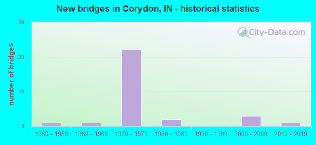
- New bridges - historical statistics
- 11950-1959
- 11960-1969
- 221970-1979
- 21980-1989
- 32000-2009
- 12010-2019

- Reconstructed bridges - Historical Statistics
- 21980-1989
- 11990-1999
- 42000-2009
- 22010-2019


- Bridge Condition - Deck
- 13.3%Very good
- 53.3%Good
- 13.3%Satisfactory
- 20.0%Fair

- Bridge Condition - Superstructure
- 13.3%Very good
- 46.7%Good
- 20.0%Satisfactory
- 20.0%Fair

- Bridge Condition - Substructure
- 6.7%Very good
- 66.7%Good
- 26.7%Satisfactory

- Bridge Condition - Channel
- 18.2%Very good
- 63.6%Good
- 9.1%Satisfactory
- 9.1%Fair
Find on map >> Show street view
Structure Number: 223, Location: 00.13 W SR 337 (Lat: 38.212331, Lng: -86.128769), Route carried "on" structure: State highway 62, Year Built: 1967, Year Reconstructed: 2015, Status: Open, Structure Length: 6.46m (21.19ft), Average Daily Traffic: 10,733 (year 2014), Truck Traffic: 10%, Average Future Daily Traffic: 15,949 (year 2034), Design Load: HS 20, Features Intersected: INDIAN CREEK
Minimum Vertical Clearance: 30+ m (98+ ft), Kilometerpoint: 15.289, Lanes on structure: 2, Owner: State Highway Agency, Approaching Roadway Width: 12.2m (40.0ft), Material/Design: Steel continuous, Design/Construction: Stringer/Multi-beam, Number Of Spans In Main Unit: 4, Length of Maximum Span: 17.7m (58.1ft), Curb or Sidewalk Widths: Left: 1.2m (3.9ft), Right: 1.2m (3.9ft), Curb-To-Curb Width: 9.1m (29.9ft), Out-to-Out Width: 12.3m (40.4ft)
Condition: Deck: Good, Superstructure: Good, Substructure: Satisfactory, Channel: Good, Operating Rating: 45.4 metric tons, Method Used To Determine Operating Rating: Load and Resistance Factor Rating (LRFR) rating reported by rating factor(RF) method using HL-93 loadings, Inventory Rating: 32.1 metric tons, Method Used To Determine Inventory Rating: Load and Resistance Factor Rating (LRFR) rating reported by rating factor(RF) method using HL-93 loadings, Structural Evaluation: Equal to present minimum criteria, Deck Geometry: Meets minimum limits, Waterway Adequacy: Equal to present desirable criteria, Approach Roadway Alignment: Equal to present desirable criteria, Designated Inspection Frequency: Every 24 months, Other Special Inspection Frequency: Every 60 months, Inspection Date: October 2020, Other Special Inspection Date: May 2017, Deck Structure Type: Concrete Cast-file-Place, Wearing Surface/Protective System: Wearing Surface: Epoxy Overlay
Find on map >> Show street view
Structure Number: 3165, Location: 00.14 S SR 62 (Lat: 38.208600, Lng: -86.126400), Route carried "on" structure: County highway 337, Year Built: 1984, Status: Open, Structure Length: 4.54m (14.90ft), Average Daily Traffic: 12,986 (year 2004), Truck Traffic: 10%, Average Future Daily Traffic: 22,013 (year 2033), Design Load: HS 20, Features Intersected: LITTLE INDIAN CREEK
Minimum Vertical Clearance: 30+ m (98+ ft), Kilometerpoint: 16.641, Lanes on structure: 2, Owner: County Highway Agency, Approaching Roadway Width: 13.4m (44.0ft), Skew: 2 degrees, Material/Design: Concrete continuous, Design/Construction: Slab, Number Of Spans In Main Unit: 5, Length of Maximum Span: 9.9m (32.5ft), Curb or Sidewalk Widths: Left: 0.1m (0.3ft), Right: 1.6m (5.2ft), Curb-To-Curb Width: 13.4m (44.0ft), Out-to-Out Width: 15.8m (51.8ft)
Condition: Deck: Fair, Superstructure: Fair, Substructure: Satisfactory, Channel: Good, Operating Rating: 54.5 metric tons, Method Used To Determine Operating Rating: Load Factor (LF), Inventory Rating: 32.6 metric tons, Method Used To Determine Inventory Rating: Load Factor (LF), Structural Evaluation: Somewhat better than minimum adequacy, Deck Geometry: Equal to present minimum criteria, Waterway Adequacy: Equal to present desirable criteria, Approach Roadway Alignment: Equal to present desirable criteria, Designated Inspection Frequency: Every 24 months, Inspection Date: July 2020, Deck Structure Type: Concrete Cast-file-Place, Wearing Surface/Protective System: Wearing Surface: Monolithic Concrete, Deck Protection: Epoxy Coated Reinforcing
Find on map >> Show street view
Structure Number: 3166, Location: 00.46 N SR 62 (Lat: 38.218900, Lng: -86.126931), Route carried "on" structure: State highway 337, Year Built: 1959, Year Reconstructed: 2000, Status: Open, Structure Length: 13.50m (44.29ft), Average Daily Traffic: 19,349 (year 2004), Truck Traffic: 2%, Average Future Daily Traffic: 34,133 (year 2031), Design Load: HS 20, Features Intersected: INDIAN CREEK, LNA&C RR
Minimum Vertical Clearance: 30+ m (98+ ft), Kilometerpoint: 2.478, Lanes on structure: 3, Owner: State Highway Agency, Approaching Roadway Width: 11.9m (39.0ft), Material/Design: Steel continuous, Design/Construction: Stringer/Multi-beam, Number Of Spans In Main Unit: 5, Number Of Approach Spans: 1, Length of Maximum Span: 25.6m (84.0ft), Curb or Sidewalk Widths: Left: 1.2m (3.9ft), Right: 1.2m (3.9ft), Curb-To-Curb Width: 12.0m (39.4ft), Out-to-Out Width: 15.4m (50.5ft)
Condition: Deck: Good, Superstructure: Good, Substructure: Good, Channel: Good, Operating Rating: 22.4 metric tons, Method Used To Determine Operating Rating: Load and Resistance Factor Rating (LRFR) rating reported by rating factor(RF) method using HL-93 loadings, Inventory Rating: 17.2 metric tons, Method Used To Determine Inventory Rating: Load and Resistance Factor Rating (LRFR) rating reported by rating factor(RF) method using HL-93 loadings, Structural Evaluation: Meets minimum limits, Deck Geometry: Meets minimum limits, Underclear: Equal to present minimum criteria, Waterway Adequacy: Better than present minimum criteria, Approach Roadway Alignment: Equal to present desirable criteria, Designated Inspection Frequency: Every 24 months, Inspection Date: July 2020, Deck Structure Type: Concrete Cast-file-Place, Wearing Surface/Protective System: Wearing Surface: Latex Concrete, Deck Protection: Epoxy Coated Reinforcing
Find on map >> Show street view
Structure Number: 3167, Location: 01.39 N SR 135 (Lat: 38.240231, Lng: -86.154461), Route carried "on" structure: State highway 337, Year Built: 1974, Year Reconstructed: 1999, Status: Open, Structure Length: 10.70m (35.10ft), Average Daily Traffic: 1,141 (year 2021), Truck Traffic: 5%, Average Future Daily Traffic: 1,233 (year 2041), Design Load: HS 20, Features Intersected: I-64 EB/WB
Minimum Vertical Clearance: 30+ m (98+ ft), Kilometerpoint: 6.164, Lanes on structure: 2, Lanes under structure: 4, Owner: State Highway Agency, Approaching Roadway Width: 10.4m (34.1ft), Skew: 4 degrees, Material/Design: Steel continuous, Design/Construction: Stringer/Multi-beam, Number Of Spans In Main Unit: 2, Number Of Approach Spans: 2, Length of Maximum Span: 37.9m (124.3ft), Curb-To-Curb Width: 10.4m (34.1ft), Out-to-Out Width: 11.3m (37.1ft)
Condition: Deck: Good, Superstructure: Satisfactory, Substructure: Satisfactory, Operating Rating: 47.3 metric tons, Method Used To Determine Operating Rating: Load and Resistance Factor Rating (LRFR) rating reported by rating factor(RF) method using HL-93 loadings, Inventory Rating: 36.6 metric tons, Method Used To Determine Inventory Rating: Load and Resistance Factor Rating (LRFR) rating reported by rating factor(RF) method using HL-93 loadings, Structural Evaluation: Equal to present minimum criteria, Deck Geometry: Equal to present minimum criteria, Underclear: Somewhat better than minimum adequacy, Approach Roadway Alignment: Equal to present desirable criteria, Designated Inspection Frequency: Every 24 months, Other Special Inspection Frequency: Every 60 months, Inspection Date: July 2020, Other Special Inspection Date: June 2018, Deck Structure Type: Concrete Cast-file-Place, Wearing Surface/Protective System: Wearing Surface: Latex Concrete
Find on map >> Show street view
Structure Number: 3419, Location: 01.51 W SR 337 (Lat: 38.241500, Lng: -86.182106), Route carried "on" structure: Interstate 64, Year Built: 1974, Year Reconstructed: 2008, Status: Open, Structure Length: 3.63m (11.91ft), Average Daily Traffic: 16,250 (year 2005), Truck Traffic: 26%, Average Future Daily Traffic: 23,989 (year 2034), Design Load: HS 20+Mod, Features Intersected: GETHSEMANE CHURCH ROAD
Minimum Vertical Clearance: 30+ m (98+ ft), Kilometerpoint: 164.073, Lanes on structure: 2, Lanes under structure: 2, Base Highway Network: Yes (, Subroute: 1), Owner: State Highway Agency, Approaching Roadway Width: 12.8m (42.0ft), Material/Design: Prestressed concrete continuous, Design/Construction: Stringer/Multi-beam, Number Of Spans In Main Unit: 3, Length of Maximum Span: 11.9m (39.0ft), Curb-To-Curb Width: 12.0m (39.4ft), Out-to-Out Width: 13.0m (42.7ft)
Condition: Deck: Good, Superstructure: Fair, Substructure: Satisfactory, Operating Rating: 48.0 metric tons, Method Used To Determine Operating Rating: Load and Resistance Factor Rating (LRFR) rating reported by rating factor(RF) method using HL-93 loadings, Inventory Rating: 36.0 metric tons, Method Used To Determine Inventory Rating: Load and Resistance Factor Rating (LRFR) rating reported by rating factor(RF) method using HL-93 loadings, Structural Evaluation: Somewhat better than minimum adequacy, Deck Geometry: Equal to present minimum criteria, Underclear: Somewhat better than minimum adequacy, Approach Roadway Alignment: Equal to present desirable criteria, Designated Inspection Frequency: Every 24 months, Inspection Date: October 2021, Deck Structure Type: Concrete Cast-file-Place, Wearing Surface/Protective System: Wearing Surface: Latex Concrete
Find on map >> Show street view
Structure Number: 342, Location: 01.51 W SR 337 (Lat: 38.241739, Lng: -86.182097), Route carried "on" structure: Interstate 64, Year Built: 1974, Year Reconstructed: 2010, Status: Open, Structure Length: 3.73m (12.24ft), Average Daily Traffic: 16,250 (year 2005), Truck Traffic: 26%, Average Future Daily Traffic: 23,989 (year 2034), Design Load: HS 20+Mod, Features Intersected: GETHSEMANE CHURCH ROAD
Minimum Vertical Clearance: 30+ m (98+ ft), Kilometerpoint: 164.073, Lanes on structure: 2, Lanes under structure: 2, Base Highway Network: Yes (, Subroute: 1), Owner: State Highway Agency, Approaching Roadway Width: 11.6m (38.1ft), Material/Design: Prestressed concrete continuous, Design/Construction: Stringer/Multi-beam, Number Of Spans In Main Unit: 3, Length of Maximum Span: 11.9m (39.0ft), Curb-To-Curb Width: 12.0m (39.4ft), Out-to-Out Width: 13.0m (42.7ft)
Condition: Deck: Good, Superstructure: Satisfactory, Substructure: Good, Operating Rating: 45.4 metric tons, Method Used To Determine Operating Rating: Load and Resistance Factor Rating (LRFR) rating reported by rating factor(RF) method using HL-93 loadings, Inventory Rating: 34.3 metric tons, Method Used To Determine Inventory Rating: Load and Resistance Factor Rating (LRFR) rating reported by rating factor(RF) method using HL-93 loadings, Structural Evaluation: Equal to present minimum criteria, Deck Geometry: Equal to present minimum criteria, Underclear: Somewhat better than minimum adequacy, Approach Roadway Alignment: Equal to present desirable criteria, Designated Inspection Frequency: Every 24 months, Inspection Date: October 2021, Deck Structure Type: Concrete Cast-file-Place, Wearing Surface/Protective System: Wearing Surface: Latex Concrete
Find on map >> Show street view
Structure Number: 3421, Location: 00.53 E SR 337 (Lat: 38.239289, Lng: -86.144911), Route carried "on" structure: Alternate County highway , Year Built: 1974, Year Reconstructed: 2014, Status: Open, Structure Length: 6.46m (21.19ft), Average Daily Traffic: 2,719 (year 2004), Truck Traffic: 10%, Average Future Daily Traffic: 4,550 (year 2030), Design Load: HS 20, Features Intersected: I-64 EB/WB, Facility Carried by Structure: CORYDON-RAMSEY RD
Minimum Vertical Clearance: 30+ m (98+ ft), Kilometerpoint: 0.000, Lanes on structure: 2, Lanes under structure: 4, Owner: State Highway Agency, Approaching Roadway Width: 10.4m (34.1ft), Material/Design: Steel continuous, Design/Construction: Stringer/Multi-beam, Number Of Spans In Main Unit: 2, Length of Maximum Span: 32.0m (105.0ft), Curb or Sidewalk Widths: Left: 0.1m (0.3ft), Right: 0.1m (0.3ft), Curb-To-Curb Width: 10.4m (34.1ft), Out-to-Out Width: 11.3m (37.1ft)
Condition: Deck: Good, Superstructure: Good, Substructure: Good, Operating Rating: 47.3 metric tons, Method Used To Determine Operating Rating: Load and Resistance Factor Rating (LRFR) rating reported by rating factor(RF) method using HL-93 loadings, Inventory Rating: 36.3 metric tons, Method Used To Determine Inventory Rating: Load and Resistance Factor Rating (LRFR) rating reported by rating factor(RF) method using HL-93 loadings, Structural Evaluation: Better than present minimum criteria, Deck Geometry: Somewhat better than minimum adequacy, Underclear: Somewhat better than minimum adequacy, Approach Roadway Alignment: Equal to present desirable criteria, Designated Inspection Frequency: Every 24 months, Inspection Date: October 2021, Deck Structure Type: Concrete Cast-file-Place, Wearing Surface/Protective System: Wearing Surface: Epoxy Overlay
Find on map >> Show street view
Structure Number: 3423, Location: 01.35 E SR 135 (Lat: 38.243319, Lng: -86.102519), Route carried "on" structure: Interstate 64, Year Built: 1974, Year Reconstructed: 1994, Status: Open, Structure Length: 11.56m (37.93ft), Average Daily Traffic: 15,774 (year 2020), Truck Traffic: 22%, Average Future Daily Traffic: 22,099 (year 2040), Design Load: HS 20, Features Intersected: INDIAN CREEK, ACCESS RD
Minimum Vertical Clearance: 30+ m (98+ ft), Kilometerpoint: 171.105, Lanes on structure: 2, Lanes under structure: 1, Base Highway Network: Yes (, Subroute: 1), Owner: State Highway Agency, Approaching Roadway Width: 12.0m (39.4ft), Skew: 2 degrees, Material/Design: Steel continuous, Design/Construction: Stringer/Multi-beam, Number Of Spans In Main Unit: 3, Number Of Approach Spans: 1, Length of Maximum Span: 39.6m (129.9ft), Curb-To-Curb Width: 12.1m (39.7ft), Out-to-Out Width: 13.0m (42.7ft)
Condition: Deck: Fair, Superstructure: Good, Substructure: Good, Channel: Satisfactory, Operating Rating: 38.2 metric tons, Method Used To Determine Operating Rating: Load and Resistance Factor Rating (LRFR) rating reported by rating factor(RF) method using HL-93 loadings, Inventory Rating: 29.5 metric tons, Method Used To Determine Inventory Rating: Load and Resistance Factor Rating (LRFR) rating reported by rating factor(RF) method using HL-93 loadings, Structural Evaluation: Better than present minimum criteria, Deck Geometry: Equal to present minimum criteria, Underclear: Meets minimum limits, Waterway Adequacy: Better than present minimum criteria, Approach Roadway Alignment: Equal to present desirable criteria, Designated Inspection Frequency: Every 24 months, Underwater Inspection Frequency: Every 60 months, Other Special Inspection Frequency: Every 60 months, Inspection Date: October 2021, Underwater Inspection Date: May 2018, Other Special Inspection Date: May 2020, Deck Structure Type: Concrete Cast-file-Place, Wearing Surface/Protective System: Wearing Surface: Latex Concrete
Find on map >> Show street view
Structure Number: 3424, Location: 01.35 E SR 135 (Lat: 38.243569, Lng: -86.102411), Route carried "on" structure: Interstate 64, Year Built: 1974, Year Reconstructed: 1994, Status: Open, Structure Length: 11.56m (37.93ft), Average Daily Traffic: 15,774 (year 2020), Truck Traffic: 22%, Average Future Daily Traffic: 22,099 (year 2040), Design Load: HS 20, Features Intersected: INDIAN CREEK, ACCESS RD
Minimum Vertical Clearance: 30+ m (98+ ft), Kilometerpoint: 171.105, Lanes on structure: 2, Lanes under structure: 1, Base Highway Network: Yes (, Subroute: 1), Owner: State Highway Agency, Approaching Roadway Width: 12.0m (39.4ft), Skew: 2 degrees, Material/Design: Steel continuous, Design/Construction: Stringer/Multi-beam, Number Of Spans In Main Unit: 3, Number Of Approach Spans: 1, Length of Maximum Span: 39.6m (129.9ft), Curb-To-Curb Width: 12.0m (39.4ft), Out-to-Out Width: 13.0m (42.7ft)
Condition: Deck: Fair, Superstructure: Good, Substructure: Good, Channel: Fair, Operating Rating: 40.5 metric tons, Method Used To Determine Operating Rating: Load and Resistance Factor Rating (LRFR) rating reported by rating factor(RF) method using HL-93 loadings, Inventory Rating: 31.1 metric tons, Method Used To Determine Inventory Rating: Load and Resistance Factor Rating (LRFR) rating reported by rating factor(RF) method using HL-93 loadings, Structural Evaluation: Better than present minimum criteria, Deck Geometry: Equal to present minimum criteria, Underclear: Meets minimum limits, Waterway Adequacy: Better than present minimum criteria, Approach Roadway Alignment: Equal to present desirable criteria, Designated Inspection Frequency: Every 24 months, Underwater Inspection Frequency: Every 60 months, Other Special Inspection Frequency: Every 60 months, Inspection Date: October 2021, Underwater Inspection Date: June 2018, Other Special Inspection Date: May 2020, Deck Structure Type: Concrete Cast-file-Place, Wearing Surface/Protective System: Wearing Surface: Latex Concrete
Find on map >> Show street view
Structure Number: 3425, Location: 02.12 E SR 135 (Lat: 38.244311, Lng: -86.092950), Route carried "on" structure: Interstate 64, Year Built: 1974, Status: Open, Structure Length: 1.40m (4.59ft), Average Daily Traffic: 30,390 (year 2004), Truck Traffic: 10%, Average Future Daily Traffic: 60,132 (year 2031), Design Load: HS 20+Mod, Features Intersected: BRUSH HEAP CREEK
Minimum Vertical Clearance: 30+ m (98+ ft), Kilometerpoint: 172.345, Lanes on structure: 4, Base Highway Network: Yes (, Subroute: 1), Owner: State Highway Agency, Approaching Roadway Width: 25.6m (84.0ft), Skew: 14 degrees, Material/Design: Concrete, Design/Construction: Culvert, Number Of Spans In Main Unit: 1, Length of Maximum Span: 12.8m (42.0ft), Curb-To-Curb Width: 21.3m (69.9ft), Out-to-Out Width: 39.6m (129.9ft)
Condition: Channel: Good, Culverts: Satisfactory, Inventory Rating: 88.2 metric tons, Method Used To Determine Inventory Rating: Field evaluation and documented engineering judgment, Structural Evaluation: Equal to present minimum criteria, Deck Geometry: Better than present minimum criteria, Waterway Adequacy: Better than present minimum criteria, Approach Roadway Alignment: Equal to present desirable criteria, Designated Inspection Frequency: Every 24 months, Inspection Date: October 2021
Find on map >> Show street view
Structure Number: 3426, Location: 02.27 E SR 135 (Lat: 38.246219, Lng: -86.087300), Route carried "on" structure: Alternate County highway , Year Built: 1974, Year Reconstructed: 2014, Status: Open, Structure Length: 8.08m (26.51ft), Average Daily Traffic: 132 (year 2004), Truck Traffic: 10%, Average Future Daily Traffic: 220 (year 2033), Design Load: HS 20, Features Intersected: I-64 EB/WB, Facility Carried by Structure: TEE ROAD
Minimum Vertical Clearance: 30+ m (98+ ft), Kilometerpoint: 0.000, Lanes on structure: 2, Lanes under structure: 4, Owner: State Highway Agency, Approaching Roadway Width: 7.3m (24.0ft), Skew: 2 degrees, Material/Design: Steel continuous, Design/Construction: Stringer/Multi-beam, Number Of Spans In Main Unit: 2, Number Of Approach Spans: 2, Length of Maximum Span: 28.0m (91.9ft), Curb or Sidewalk Widths: Left: 0.1m (0.3ft), Right: 0.1m (0.3ft), Curb-To-Curb Width: 9.8m (32.2ft), Out-to-Out Width: 10.7m (35.1ft)
Condition: Deck: Satisfactory, Superstructure: Satisfactory, Substructure: Good, Operating Rating: 48.6 metric tons, Method Used To Determine Operating Rating: Load and Resistance Factor Rating (LRFR) rating reported by rating factor(RF) method using HL-93 loadings, Inventory Rating: 37.3 metric tons, Method Used To Determine Inventory Rating: Load and Resistance Factor Rating (LRFR) rating reported by rating factor(RF) method using HL-93 loadings, Structural Evaluation: Equal to present minimum criteria, Deck Geometry: Better than present minimum criteria, Underclear: Somewhat better than minimum adequacy, Approach Roadway Alignment: Equal to present desirable criteria, Designated Inspection Frequency: Every 24 months, Other Special Inspection Frequency: Every 60 months, Inspection Date: October 2021, Other Special Inspection Date: June 2018, Deck Structure Type: Concrete Cast-file-Place, Wearing Surface/Protective System: Wearing Surface: Epoxy Overlay
Find on map >> Show street view
Structure Number: 3100015, Location: 00.20 S OF SR 62 (Lat: 38.199600, Lng: -86.095153), Route carried "on" structure: County highway , Year Built: 1982, Status: Open, Structure Length: 6.16m (20.21ft), Average Daily Traffic: 7,280 (year 2018), Truck Traffic: 5%, Average Future Daily Traffic: 11,960 (year 2038), Features Intersected: LITTLE INDIAN CREEK, Facility Carried by Structure: CORYDON-NEW MDDLTN
Minimum Vertical Clearance: 30+ m (98+ ft), Kilometerpoint: 0.000, Lanes on structure: 2, Owner: County Highway Agency, Approaching Roadway Width: 6.7m (22.0ft), Skew: 4 degrees, Material/Design: Steel continuous, Design/Construction: Stringer/Multi-beam, Number Of Spans In Main Unit: 3, Length of Maximum Span: 24.4m (80.1ft), Curb-To-Curb Width: 8.6m (28.2ft), Out-to-Out Width: 9.3m (30.5ft)
Condition: Deck: Satisfactory, Superstructure: Fair, Substructure: Good, Channel: Good, Operating Rating: 41.8 metric tons, Method Used To Determine Operating Rating: Load and Resistance Factor (LRFR), Inventory Rating: 41.8 metric tons, Method Used To Determine Inventory Rating: Load and Resistance Factor (LRFR), Structural Evaluation: Somewhat better than minimum adequacy, Deck Geometry: Meets minimum limits, Waterway Adequacy: Better than present minimum criteria, Approach Roadway Alignment: Equal to present minimum criteria, Length Of Structure Improvement: 6.16m (20.21ft), Designated Inspection Frequency: Every 24 months, Inspection Date: August 2020, Bridge Improvement Cost: $700,000, Roadway Improvement Cost: $1,200,000, Total Project Cost: $2,250,000 ( Estimate for 2020), Deck Structure Type: Concrete Cast-file-Place, Wearing Surface/Protective System: Wearing Surface: Monolithic Concrete
Find on map >> Show street view
Structure Number: 3100035, Location: 00.10 W OF HOTTEL RD (Lat: 38.190531, Lng: -86.181847), Route carried "on" structure: Alternate County highway , Year Built: 2003, Status: Open, Structure Length: 5.37m (17.62ft), Average Daily Traffic: 100 (year 2018), Truck Traffic: 5%, Average Future Daily Traffic: 160 (year 2038), Design Load: HS 20, Features Intersected: INDIAN CREEK, Facility Carried by Structure: MATHIS RD
Minimum Vertical Clearance: 30+ m (98+ ft), Kilometerpoint: 0.000, Lanes on structure: 2, Owner: County Highway Agency, Approaching Roadway Width: 5.5m (18.0ft), Skew: 2 degrees, Material/Design: Prestressed concrete continuous, Design/Construction: Box Beam or Girders - Single/Spread, Number Of Spans In Main Unit: 3, Length of Maximum Span: 16.8m (55.1ft), Curb-To-Curb Width: 7.7m (25.3ft), Out-to-Out Width: 7.9m (25.9ft)
Condition: Deck: Good, Superstructure: Very good, Substructure: Good, Channel: Very good, Operating Rating: 68.9 metric tons, Method Used To Determine Operating Rating: Load and Resistance Factor (LRFR), Inventory Rating: 34.9 metric tons, Method Used To Determine Inventory Rating: Load and Resistance Factor (LRFR), Structural Evaluation: Better than present minimum criteria, Deck Geometry: Equal to present minimum criteria, Waterway Adequacy: Equal to present desirable criteria, Approach Roadway Alignment: High priority of corrective action, Designated Inspection Frequency: Every 24 months, Inspection Date: August 2020, Deck Structure Type: Concrete Cast-file-Place, Wearing Surface/Protective System: Wearing Surface: Monolithic Concrete
Find on map >> Show street view
Structure Number: 3100088, Location: 00.10 SE OF BIG INDIAN RD (Lat: 38.241950, Lng: -86.098472), Route carried "on" structure: Alternate County highway , Year Built: 2005, Status: Open, Structure Length: 1.25m (4.10ft), Average Daily Traffic: 240 (year 2018), Truck Traffic: 1%, Average Future Daily Traffic: 390 (year 2038), Design Load: HS 20, Features Intersected: BRUSH HEAP CREEK, Facility Carried by Structure: OWANS LN
Minimum Vertical Clearance: 30+ m (98+ ft), Kilometerpoint: 0.000, Lanes on structure: 2, Owner: County Highway Agency, Approaching Roadway Width: 6.1m (20.0ft), Material/Design: Prestressed concrete, Design/Construction: Box Beam or Girders - Multiple, Number Of Spans In Main Unit: 1, Length of Maximum Span: 12.0m (39.4ft), Curb-To-Curb Width: 7.2m (23.6ft), Out-to-Out Width: 7.4m (24.3ft)
Condition: Deck: Good, Superstructure: Good, Substructure: Good, Channel: Good, Operating Rating: 54.8 metric tons, Method Used To Determine Operating Rating: Load and Resistance Factor (LRFR), Inventory Rating: 33.9 metric tons, Method Used To Determine Inventory Rating: Load and Resistance Factor (LRFR), Structural Evaluation: Better than present minimum criteria, Deck Geometry: Meets minimum limits, Waterway Adequacy: Equal to present minimum criteria, Approach Roadway Alignment: High priority of corrective action, Designated Inspection Frequency: Every 24 months, Inspection Date: August 2020, Deck Structure Type: Concrete Precast Panels, Wearing Surface/Protective System: Wearing Surface: Bituminous
Find on map >> Show street view
Structure Number: 310009, Location: 00.10 N OF MAIN ST(LANESV (Lat: 38.234789, Lng: -85.983439), Route carried "on" structure: Alternate City street , Year Built: 2008, Status: Open, Structure Length: 0.98m (3.22ft), Average Daily Traffic: 60 (year 2018), Truck Traffic: 5%, Average Future Daily Traffic: 100 (year 2038), Design Load: HS 20, Features Intersected: PANTHER CREEK, Facility Carried by Structure: ZOLLMAN RD
Minimum Vertical Clearance: 30+ m (98+ ft), Kilometerpoint: 0.000, Lanes on structure: 2, Owner: County Highway Agency, Approaching Roadway Width: 6.7m (22.0ft), Material/Design: Concrete, Design/Construction: Slab, Number Of Spans In Main Unit: 1, Length of Maximum Span: 9.1m (29.9ft), Curb-To-Curb Width: 8.1m (26.6ft), Out-to-Out Width: 8.2m (26.9ft)
Condition: Deck: Very good, Superstructure: Good, Substructure: Very good, Channel: Very good, Operating Rating: 32.7 metric tons, Method Used To Determine Operating Rating: Field evaluation and documented engineering judgment, Inventory Rating: 32.7 metric tons, Method Used To Determine Inventory Rating: Field evaluation and documented engineering judgment, Structural Evaluation: Better than present minimum criteria, Deck Geometry: Equal to present minimum criteria, Waterway Adequacy: Better than present minimum criteria, Approach Roadway Alignment: High priority of corrective action, Designated Inspection Frequency: Every 24 months, Inspection Date: August 2020, Deck Structure Type: Concrete Precast Panels, Wearing Surface/Protective System: Wearing Surface: Bituminous
Find on map >> Show street view
Structure Number: 3100094, Location: 02.9 W PFRIMMER CHAPEL RD (Lat: 38.240058, Lng: -86.102347), Route carried "on" structure: Alternate County highway , Year Built: 2014, Status: Open, Structure Length: 1.87m (6.14ft), Average Daily Traffic: 1,610 (year 2018), Truck Traffic: 5%, Average Future Daily Traffic: 2,650 (year 2038), Features Intersected: BRUSH HEAP CREEK, Facility Carried by Structure: BIG INDIAN RD
Minimum Vertical Clearance: 30+ m (98+ ft), Kilometerpoint: 0.000, Lanes on structure: 2, Owner: County Highway Agency, Approaching Roadway Width: 6.7m (22.0ft), Material/Design: Prestressed concrete, Design/Construction: Box Beam or Girders - Multiple, Number Of Spans In Main Unit: 1, Length of Maximum Span: 18.3m (60.0ft), Curb-To-Curb Width: 8.5m (27.9ft), Out-to-Out Width: 9.8m (32.2ft)
Condition: Deck: Very good, Superstructure: Very good, Substructure: Good, Channel: Good, Operating Rating: 62.0 metric tons, Method Used To Determine Operating Rating: Load and Resistance Factor (LRFR), Inventory Rating: 45.2 metric tons, Method Used To Determine Inventory Rating: Load and Resistance Factor (LRFR), Structural Evaluation: Better than present minimum criteria, Deck Geometry: Somewhat better than minimum adequacy, Waterway Adequacy: Superior to present desirable criteria, Approach Roadway Alignment: Equal to present minimum criteria, Designated Inspection Frequency: Every 24 months, Inspection Date: August 2020, Deck Structure Type: Concrete Cast-file-Place, Wearing Surface/Protective System: Wearing Surface: Monolithic Concrete
Find on map >> Show street view
Structure Number: 2637, Location: 00.91 N SR 337 (Lat: 38.239531, Lng: -86.127014), Route carried "under" structure: Interstate 64, Year Built: 1974, Structure Length: 0. m, Average Daily Traffic: 15,350 (year 2005), Truck Traffic: 10%, Features Intersected: SR 135
Minimum Vertical Clearance: 8.64m (28.35ft), Kilometerpoint: 168.933, Lanes on structure: 4, Lanes under structure: 3, Material/Design: Steel continuous, Design/Construction: Stringer/Multi-beam, Length of Maximum Span: 27.4m (89.9ft)
Find on map >> Show street view
Structure Number: 2637, Location: 00.91 N SR 337 (Lat: 38.239531, Lng: -86.127014), Route carried "under" structure: Interstate 64, Year Built: 1974, Structure Length: 0. m, Average Daily Traffic: 15,195 (year 2004), Truck Traffic: 10%, Features Intersected: SR 135
Minimum Vertical Clearance: 8.64m (28.35ft), Kilometerpoint: 168.933, Lanes on structure: 4, Lanes under structure: 3, Material/Design: Steel continuous, Design/Construction: Stringer/Multi-beam, Length of Maximum Span: 27.4m (89.9ft)
Find on map >> Show street view
Structure Number: 3167, Location: 01.39 N SR 135 (Lat: 38.240231, Lng: -86.154464), Route carried "under" structure: Interstate 64, Year Built: 1974, Structure Length: 0. m, Average Daily Traffic: 9,185 (year 2004), Truck Traffic: 10%, Features Intersected: I-64 EBL, Facility Carried by Structure: SR 337
Minimum Vertical Clearance: 5.13m (16.83ft), Kilometerpoint: 166.503, Lanes on structure: 2, Lanes under structure: 4, Material/Design: Steel continuous, Design/Construction: Stringer/Multi-beam, Length of Maximum Span: 37.9m (124.3ft)
Find on map >> Show street view
Structure Number: 3167, Location: 01.39 N SR 135 (Lat: 38.240231, Lng: -86.154464), Route carried "under" structure: Interstate 64, Year Built: 1974, Structure Length: 0. m, Average Daily Traffic: 9,185 (year 2004), Truck Traffic: 10%, Features Intersected: I-64 WBL, Facility Carried by Structure: SR 337
Minimum Vertical Clearance: 5.13m (16.83ft), Kilometerpoint: 166.503, Lanes on structure: 2, Lanes under structure: 4, Material/Design: Steel continuous, Design/Construction: Stringer/Multi-beam, Length of Maximum Span: 37.9m (124.3ft)
Find on map >> Show street view
Structure Number: 3419, Location: 01.51 W SR-337 (Lat: 38.241500, Lng: -86.182106), Route carried "under" structure: County highway , Year Built: 1974, Structure Length: 0. m, Average Daily Traffic: 132 (year 2004), Truck Traffic: 5%, Features Intersected: GETHSEMANE CHURCH ROAD, Facility Carried by Structure: I-64 EB
Minimum Vertical Clearance: 4.42m (14.50ft), Kilometerpoint: 0.000, Lanes on structure: 2, Lanes under structure: 2, Material/Design: Prestressed concrete continuous, Design/Construction: Stringer/Multi-beam, Length of Maximum Span: 11.9m (39.0ft)
Find on map >> Show street view
Structure Number: 342, Location: 01.51 W SR-337 (Lat: 38.241739, Lng: -86.182097), Route carried "under" structure: County highway , Year Built: 1974, Structure Length: 0. m, Average Daily Traffic: 132 (year 2004), Truck Traffic: 5%, Features Intersected: GETHSEMANE CHURCH ROAD, Facility Carried by Structure: I-64 WB
Minimum Vertical Clearance: 4.42m (14.50ft), Kilometerpoint: 0.000, Lanes on structure: 2, Lanes under structure: 2, Material/Design: Prestressed concrete continuous, Design/Construction: Stringer/Multi-beam, Length of Maximum Span: 11.9m (39.0ft)
Find on map >> Show street view
Structure Number: 3421, Location: 00.53 E SR 337 (Lat: 38.239289, Lng: -86.144906), Route carried "under" structure: Interstate 64, Year Built: 1974, Structure Length: 0. m, Average Daily Traffic: 9,186 (year 2004), Truck Traffic: 10%, Features Intersected: I-64 EBL, Facility Carried by Structure: CORYDON-RAMSEY RD
Minimum Vertical Clearance: 4.95m (16.24ft), Kilometerpoint: 167.356, Lanes on structure: 2, Lanes under structure: 4, Material/Design: Steel continuous, Design/Construction: Stringer/Multi-beam, Length of Maximum Span: 32.0m (105.0ft)
Find on map >> Show street view
Structure Number: 3421, Location: 00.53 E SR 337 (Lat: 38.239289, Lng: -86.144906), Route carried "under" structure: Interstate 64, Year Built: 1974, Structure Length: 0. m, Average Daily Traffic: 9,186 (year 2004), Truck Traffic: 10%, Features Intersected: I-64 WBL, Facility Carried by Structure: CORYDON-RAMSEY RD
Minimum Vertical Clearance: 4.93m (16.17ft), Kilometerpoint: 167.356, Lanes on structure: 2, Lanes under structure: 4, Material/Design: Steel continuous, Design/Construction: Stringer/Multi-beam, Length of Maximum Span: 32.0m (105.0ft)
Find on map >> Show street view
Structure Number: 3422, Location: 00.03 E SR 135 (Lat: 38.239569, Lng: -86.126389), Route carried "under" structure: Interstate 64, Year Built: 1974, Structure Length: 0. m, Average Daily Traffic: 15,195 (year 2004), Truck Traffic: 10%, Features Intersected: I-64 EB, Facility Carried by Structure: LNA & C RR
Minimum Vertical Clearance: 5.01m (16.44ft), Kilometerpoint: 168.981, Lanes under structure: 6, Material/Design: Steel, Design/Construction: Girder and Floorbeam System, Length of Maximum Span: 27.6m (90.6ft)
Find on map >> Show street view
Structure Number: 3422, Location: 00.03 E SR 135 (Lat: 38.239569, Lng: -86.126389), Route carried "under" structure: Interstate 64, Year Built: 1974, Structure Length: 0. m, Average Daily Traffic: 15,195 (year 2004), Truck Traffic: 10%, Features Intersected: I-64 WB, Facility Carried by Structure: LNA & C RR
Minimum Vertical Clearance: 5.44m (17.85ft), Kilometerpoint: 168.981, Lanes under structure: 6, Material/Design: Steel, Design/Construction: Girder and Floorbeam System, Length of Maximum Span: 27.6m (90.6ft)
Find on map >> Show street view
Structure Number: 3423, Location: 01.35 E SR-135 (Lat: 38.243319, Lng: -86.102525), Route carried "under" structure: ServiceCounty highway , Year Built: 1974, Structure Length: 0. m, Average Daily Traffic: 132 (year 2004), Truck Traffic: 10%, Features Intersected: ACCESS ROAD, Facility Carried by Structure: I-64 EB
Minimum Vertical Clearance: 3.66m (12.01ft), Kilometerpoint: 0.000, Lanes on structure: 2, Lanes under structure: 1, Material/Design: Steel continuous, Design/Construction: Stringer/Multi-beam, Length of Maximum Span: 39.6m (129.9ft)
Find on map >> Show street view
Structure Number: 3424, Location: 01.35 E SR-135 (Lat: 38.243569, Lng: -86.102408), Route carried "under" structure: ServiceCounty highway , Year Built: 1974, Structure Length: 0. m, Average Daily Traffic: 132 (year 2004), Truck Traffic: 10%, Features Intersected: ACCESS ROAD, Facility Carried by Structure: I-64 WB
Minimum Vertical Clearance: 3.91m (12.83ft), Kilometerpoint: 0.000, Lanes on structure: 2, Lanes under structure: 1, Material/Design: Steel continuous, Design/Construction: Stringer/Multi-beam, Length of Maximum Span: 39.6m (129.9ft)
Find on map >> Show street view
Structure Number: 3426, Location: 02.27 E SR 135 (Lat: 38.246219, Lng: -86.087303), Route carried "under" structure: Interstate 64, Year Built: 1974, Structure Length: 0. m, Average Daily Traffic: 15,195 (year 2004), Truck Traffic: 10%, Features Intersected: I-64 EBL, Facility Carried by Structure: TEE ROAD
Minimum Vertical Clearance: 7.11m (23.33ft), Kilometerpoint: 172.586, Lanes on structure: 2, Lanes under structure: 4, Material/Design: Steel continuous, Design/Construction: Stringer/Multi-beam, Length of Maximum Span: 28.0m (91.9ft)
Find on map >> Show street view
Structure Number: 3426, Location: 02.27 E SR-135 (Lat: 38.246219, Lng: -86.087303), Route carried "under" structure: Interstate 64, Year Built: 1974, Structure Length: 0. m, Average Daily Traffic: 15,195 (year 2004), Truck Traffic: 10%, Features Intersected: I-64 WBL, Facility Carried by Structure: TEE ROAD
Minimum Vertical Clearance: 5.41m (17.75ft), Kilometerpoint: 172.586, Lanes on structure: 2, Lanes under structure: 4, Material/Design: Steel continuous, Design/Construction: Stringer/Multi-beam, Length of Maximum Span: 28.0m (91.9ft)