Bridge Statistics for Cottleville, Missouri (MO)
Condition, Traffic, Stress, Structural Evaluation, Project Costs
- National Bridge Inventory (NBI) Statistics
- 14Number of bridges
- 121ft / 37.1mTotal length
- 176,158Total average daily traffic
- 9,677Total average daily truck traffic
- National Bridge Inventory (NBI) Registered Bridges for Cottleville
- No street view available for this location
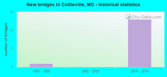
- New bridges - historical statistics
- 11990-1999
- 132010-2019


- Bridge Condition - Superstructure
- 87.5%Good
- 12.5%Satisfactory

- Bridge Condition - Substructure
- 25.0%Excellent
- 25.0%Very good
- 50.0%Good

- Bridge Condition - Channel
- 85.7%Satisfactory
- 14.3%Fair
Find on map >> Show street view
Structure Number: 33269, Location: S 1669 T 46 N R 3 E (Lat: 38.732564, Lng: -90.667558), Route carried "on" structure: County highway , Year Built: 2010, Status: Open, Structure Length: 1.04m (3.41ft), Average Daily Traffic: 4,551 (year 2020), Truck Traffic: 2%, Average Future Daily Traffic: 7,054 (year 2040), Design Load: HS 20, Features Intersected: TRIB TO CROOKED CR, Facility Carried by Structure: GUTERMUTH RD
Minimum Vertical Clearance: 30+ m (98+ ft), Kilometerpoint: 1.276, Lanes on structure: 3, Owner: City or Municipal Highway Agency, Maintenance Responsibility: County Highway Agency, Approaching Roadway Width: 12.2m (40.0ft), Skew: 2 degrees, Material/Design: Concrete, Design/Construction: Culvert, Number Of Spans In Main Unit: 3, Length of Maximum Span: 3.0m (9.8ft), Curb or Sidewalk Widths: Left: 1.5m (4.9ft), Right: 1.5m (4.9ft), Curb-To-Curb Width: 12.2m (40.0ft), Out-to-Out Width: 12.2m (40.0ft)
Condition: Channel: Fair, Culverts: Satisfactory, Operating Rating: 54.0 metric tons, Method Used To Determine Operating Rating: Load Factor (LF), Inventory Rating: 32.4 metric tons, Method Used To Determine Inventory Rating: Load Factor (LF), Structural Evaluation: Equal to present minimum criteria, Deck Geometry: Meets minimum limits, Waterway Adequacy: Superior to present desirable criteria, Approach Roadway Alignment: Equal to present desirable criteria, Designated Inspection Frequency: Every 24 months, Inspection Date: Febuary 2022, Deck Structure Type: Concrete Cast-file-Place, Wearing Surface/Protective System: Wearing Surface: Other
Find on map >> Show street view
Structure Number: 34482, Location: S 57 T 46 N R 3 E (Lat: 38.734889, Lng: -90.666000), Route carried "on" structure: County highway , Year Built: 2013, Status: Open, Structure Length: 6.12m (20.08ft), Average Daily Traffic: 3,820 (year 2021), Truck Traffic: 3%, Average Future Daily Traffic: 7,449 (year 2041), Features Intersected: MO 364, Facility Carried by Structure: GUTERMUTH RD E
Minimum Vertical Clearance: 30+ m (98+ ft), Kilometerpoint: 1.568, Lanes on structure: 3, Lanes under structure: 4, Owner: State Highway Agency, Approaching Roadway Width: 12.2m (40.0ft), Material/Design: Prestressed concrete continuous, Design/Construction: Stringer/Multi-beam, Number Of Spans In Main Unit: 2, Length of Maximum Span: 30.5m (100.1ft), Curb or Sidewalk Widths: Left: 1.6m (5.2ft), Right: 1.6m (5.2ft), Curb-To-Curb Width: 12.2m (40.0ft), Out-to-Out Width: 16.5m (54.1ft)
Condition: Deck: Good, Superstructure: Good, Substructure: Excellent, Operating Rating: 58.5 metric tons, Method Used To Determine Operating Rating: Load Factor (LF), Inventory Rating: 35.1 metric tons, Method Used To Determine Inventory Rating: Load Factor (LF), Structural Evaluation: Better than present minimum criteria, Deck Geometry: Meets minimum limits, Underclear: Meets minimum limits, Approach Roadway Alignment: Equal to present desirable criteria, Designated Inspection Frequency: Every 48 months, Inspection Date: September 2021, Deck Structure Type: Concrete Cast-file-Place, Wearing Surface/Protective System: Wearing Surface: Monolithic Concrete, Deck Protection: Epoxy Coated Reinforcing
Find on map >> Show street view
Structure Number: 34577, Location: S 948 T 46 N R 3 E (Lat: 38.733800, Lng: -90.650300), Route carried "on" structure: State highway 364, Year Built: 2014, Status: Open, Structure Length: 2.29m (7.51ft), Average Daily Traffic: 17,924 (year 2021), Truck Traffic: 5%, Average Future Daily Traffic: 30,471 (year 2041), Features Intersected: CRD MOTHERHEAD RD
Minimum Vertical Clearance: 30+ m (98+ ft), Kilometerpoint: 21.594, Lanes on structure: 2, Lanes under structure: 3, Base Highway Network: Yes, Owner: State Highway Agency, Approaching Roadway Width: 11.6m (38.1ft), Skew: 2 degrees, Material/Design: Prestressed concrete, Design/Construction: Stringer/Multi-beam, Number Of Spans In Main Unit: 1, Length of Maximum Span: 21.6m (70.9ft), Curb-To-Curb Width: 11.6m (38.1ft), Out-to-Out Width: 12.4m (40.7ft)
Condition: Deck: Good, Superstructure: Good, Substructure: Good, Operating Rating: 70.2 metric tons, Method Used To Determine Operating Rating: Load Factor (LF), Inventory Rating: 41.4 metric tons, Method Used To Determine Inventory Rating: Load Factor (LF), Structural Evaluation: Better than present minimum criteria, Deck Geometry: Equal to present minimum criteria, Underclear: Meets minimum limits, Approach Roadway Alignment: Equal to present desirable criteria, Designated Inspection Frequency: Every 24 months, Inspection Date: September 2021, Deck Structure Type: Concrete Cast-file-Place, Wearing Surface/Protective System: Wearing Surface: Monolithic Concrete, Deck Protection: Epoxy Coated Reinforcing
Find on map >> Show street view
Structure Number: 34578, Location: S 948 T 46 N R 3 E (Lat: 38.733600, Lng: -90.650300), Route carried "on" structure: State highway 364, Year Built: 2014, Status: Open, Structure Length: 2.29m (7.51ft), Average Daily Traffic: 16,867 (year 2021), Truck Traffic: 6%, Average Future Daily Traffic: 28,674 (year 2041), Features Intersected: CRD MOTHERHEAD RD
Minimum Vertical Clearance: 30+ m (98+ ft), Kilometerpoint: 12.786, Lanes on structure: 2, Lanes under structure: 3, Base Highway Network: Yes, Owner: State Highway Agency, Approaching Roadway Width: 11.6m (38.1ft), Skew: 2 degrees, Material/Design: Prestressed concrete, Design/Construction: Stringer/Multi-beam, Number Of Spans In Main Unit: 1, Length of Maximum Span: 21.6m (70.9ft), Curb-To-Curb Width: 11.6m (38.1ft), Out-to-Out Width: 12.4m (40.7ft)
Condition: Deck: Good, Superstructure: Good, Substructure: Good, Operating Rating: 70.2 metric tons, Method Used To Determine Operating Rating: Load Factor (LF), Inventory Rating: 41.4 metric tons, Method Used To Determine Inventory Rating: Load Factor (LF), Structural Evaluation: Better than present minimum criteria, Deck Geometry: Equal to present minimum criteria, Underclear: Meets minimum limits, Approach Roadway Alignment: Equal to present desirable criteria, Designated Inspection Frequency: Every 24 months, Inspection Date: September 2021, Deck Structure Type: Concrete Cast-file-Place, Wearing Surface/Protective System: Wearing Surface: Monolithic Concrete, Deck Protection: Epoxy Coated Reinforcing
Find on map >> Show street view
Structure Number: 34597, Location: S 57 T 46 N R 3 E (Lat: 38.739000, Lng: -90.668000), Route carried "on" structure: State highway 364, Year Built: 2014, Status: Open, Structure Length: 2.46m (8.07ft), Average Daily Traffic: 16,867 (year 2021), Truck Traffic: 6%, Average Future Daily Traffic: 28,674 (year 2041), Features Intersected: CROOKED CR
Minimum Vertical Clearance: 30+ m (98+ ft), Kilometerpoint: 10.794, Lanes on structure: 2, Base Highway Network: Yes, Owner: State Highway Agency, Approaching Roadway Width: 11.6m (38.1ft), Skew: 2 degrees, Material/Design: Prestressed concrete, Design/Construction: Stringer/Multi-beam, Number Of Spans In Main Unit: 1, Length of Maximum Span: 23.5m (77.1ft), Curb-To-Curb Width: 11.6m (38.1ft), Out-to-Out Width: 12.4m (40.7ft)
Condition: Deck: Good, Superstructure: Good, Substructure: Very good, Channel: Satisfactory, Operating Rating: 67.5 metric tons, Method Used To Determine Operating Rating: Load Factor (LF), Inventory Rating: 36.9 metric tons, Method Used To Determine Inventory Rating: Load Factor (LF), Structural Evaluation: Better than present minimum criteria, Deck Geometry: Equal to present minimum criteria, Waterway Adequacy: Superior to present desirable criteria, Approach Roadway Alignment: Equal to present desirable criteria, Designated Inspection Frequency: Every 24 months, Inspection Date: September 2021, Deck Structure Type: Concrete Cast-file-Place, Wearing Surface/Protective System: Wearing Surface: Monolithic Concrete, Deck Protection: Epoxy Coated Reinforcing
Find on map >> Show street view
Structure Number: 34598, Location: S 57 T 46 N R 3 E (Lat: 38.739000, Lng: -90.667000), Route carried "on" structure: State highway 364, Year Built: 2014, Year Reconstructed: 2019, Status: Open, Structure Length: 2.46m (8.07ft), Average Daily Traffic: 17,924 (year 2021), Truck Traffic: 5%, Average Future Daily Traffic: 30,471 (year 2041), Features Intersected: CROOKED CREEK
Minimum Vertical Clearance: 30+ m (98+ ft), Kilometerpoint: 23.561, Lanes on structure: 2, Base Highway Network: Yes, Owner: State Highway Agency, Approaching Roadway Width: 14.0m (45.9ft), Skew: 2 degrees, Material/Design: Prestressed concrete, Design/Construction: Stringer/Multi-beam, Number Of Spans In Main Unit: 1, Length of Maximum Span: 23.5m (77.1ft), Curb-To-Curb Width: 14.0m (45.9ft), Out-to-Out Width: 14.8m (48.6ft)
Condition: Deck: Good, Superstructure: Good, Substructure: Good, Channel: Satisfactory, Operating Rating: 64.8 metric tons, Method Used To Determine Operating Rating: Load Factor (LF), Inventory Rating: 36.9 metric tons, Method Used To Determine Inventory Rating: Load Factor (LF), Structural Evaluation: Better than present minimum criteria, Deck Geometry: Superior to present desirable criteria, Waterway Adequacy: Superior to present desirable criteria, Approach Roadway Alignment: Equal to present desirable criteria, Designated Inspection Frequency: Every 24 months, Inspection Date: September 2021, Deck Structure Type: Concrete Cast-file-Place, Wearing Surface/Protective System: Wearing Surface: Monolithic Concrete, Deck Protection: Epoxy Coated Reinforcing
Find on map >> Show street view
Structure Number: 34599, Location: S 15 T 46 N R 3 E (Lat: 38.744722, Lng: -90.677500), Route carried "on" structure: State highway 364, Year Built: 2014, Status: Open, Structure Length: 6.58m (21.59ft), Average Daily Traffic: 16,867 (year 2021), Truck Traffic: 6%, Average Future Daily Traffic: 28,674 (year 2041), Features Intersected: DARDENNE CREEK, BIKE PAT
Minimum Vertical Clearance: 30+ m (98+ ft), Kilometerpoint: 9.724, Lanes on structure: 2, Base Highway Network: Yes, Owner: State Highway Agency, Approaching Roadway Width: 9.8m (32.2ft), Skew: 2 degrees, Material/Design: Prestressed concrete continuous, Design/Construction: Stringer/Multi-beam, Number Of Spans In Main Unit: 2, Length of Maximum Span: 32.3m (106.0ft), Curb-To-Curb Width: 9.8m (32.2ft), Out-to-Out Width: 10.6m (34.8ft)
Condition: Deck: Good, Superstructure: Good, Substructure: Very good, Channel: Satisfactory, Operating Rating: 77.4 metric tons, Method Used To Determine Operating Rating: Load Factor (LF), Inventory Rating: 46.8 metric tons, Method Used To Determine Inventory Rating: Load Factor (LF), Structural Evaluation: Better than present minimum criteria, Deck Geometry: Meets minimum limits, Waterway Adequacy: Superior to present desirable criteria, Approach Roadway Alignment: Equal to present desirable criteria, Designated Inspection Frequency: Every 24 months, Inspection Date: September 2021, Deck Structure Type: Concrete Cast-file-Place, Wearing Surface/Protective System: Wearing Surface: Monolithic Concrete, Deck Protection: Epoxy Coated Reinforcing
Find on map >> Show street view
Structure Number: 346, Location: S 15 T 46 N R 3 E (Lat: 38.745556, Lng: -90.677500), Route carried "on" structure: State highway 364, Year Built: 2014, Status: Open, Structure Length: 6.58m (21.59ft), Average Daily Traffic: 17,924 (year 2021), Truck Traffic: 5%, Average Future Daily Traffic: 30,471 (year 2041), Features Intersected: DARDENNE CR, BIKE PATH
Minimum Vertical Clearance: 30+ m (98+ ft), Kilometerpoint: 24.588, Lanes on structure: 2, Base Highway Network: Yes, Owner: State Highway Agency, Approaching Roadway Width: 9.8m (32.2ft), Skew: 2 degrees, Material/Design: Prestressed concrete continuous, Design/Construction: Stringer/Multi-beam, Number Of Spans In Main Unit: 2, Length of Maximum Span: 32.3m (106.0ft), Curb-To-Curb Width: 9.8m (32.2ft), Out-to-Out Width: 10.6m (34.8ft)
Condition: Deck: Good, Superstructure: Satisfactory, Substructure: Excellent, Channel: Satisfactory, Operating Rating: 77.4 metric tons, Method Used To Determine Operating Rating: Load Factor (LF), Inventory Rating: 46.8 metric tons, Method Used To Determine Inventory Rating: Load Factor (LF), Structural Evaluation: Equal to present minimum criteria, Deck Geometry: Meets minimum limits, Waterway Adequacy: Superior to present desirable criteria, Approach Roadway Alignment: Equal to present desirable criteria, Designated Inspection Frequency: Every 24 months, Inspection Date: September 2021, Deck Structure Type: Concrete Cast-file-Place, Wearing Surface/Protective System: Wearing Surface: Monolithic Concrete, Deck Protection: Epoxy Coated Reinforcing
Find on map >> Show street view
Structure Number: 36177, Location: S 15 T 46 N R 3 E (Lat: 38.747250, Lng: -90.671222), Route carried "on" structure: City street , Year Built: 2016, Status: Open, Structure Length: 0.64m (2.10ft), Average Daily Traffic: 10,000 (year 2020), Truck Traffic: 4%, Average Future Daily Traffic: 15,500 (year 2040), Features Intersected: TRIB DARDENNE CR, Facility Carried by Structure: OLD RT N
Minimum Vertical Clearance: 30+ m (98+ ft), Kilometerpoint: 2.736, Lanes on structure: 2, Owner: City or Municipal Highway Agency, Approaching Roadway Width: 13.4m (44.0ft), Skew: 3 degrees, Material/Design: Concrete, Design/Construction: Culvert, Number Of Spans In Main Unit: 2, Length of Maximum Span: 3.0m (9.8ft)
Condition: Channel: Satisfactory, Culverts: Satisfactory, Operating Rating: 98.1 metric tons, Method Used To Determine Operating Rating: Load Factor (LF), Inventory Rating: 58.5 metric tons, Method Used To Determine Inventory Rating: Load Factor (LF), Structural Evaluation: Equal to present minimum criteria, Waterway Adequacy: Superior to present desirable criteria, Approach Roadway Alignment: Equal to present desirable criteria, Designated Inspection Frequency: Every 24 months, Inspection Date: Febuary 2022
Find on map >> Show street view
Structure Number: 36178, Location: S 304 T 46 N R 3 E (Lat: 38.751831, Lng: -90.652758), Route carried "on" structure: City street , Year Built: 1991, Status: Open, Structure Length: 6.64m (21.78ft), Average Daily Traffic: 10,203 (year 2020), Truck Traffic: 10%, Average Future Daily Traffic: 15,815 (year 2040), Design Load: HS 20, Features Intersected: DARDENNE CR, Facility Carried by Structure: OLD RT N
Minimum Vertical Clearance: 30+ m (98+ ft), Kilometerpoint: 4.780, Lanes on structure: 2, Owner: City or Municipal Highway Agency, Approaching Roadway Width: 12.2m (40.0ft), Skew: 1 degrees, Material/Design: Prestressed concrete continuous, Design/Construction: Stringer/Multi-beam, Number Of Spans In Main Unit: 3, Length of Maximum Span: 21.9m (71.9ft), Curb or Sidewalk Widths: Left: 0.2m (0.7ft), Right: 0.2m (0.7ft), Curb-To-Curb Width: 11.8m (38.7ft), Out-to-Out Width: 12.7m (41.7ft)
Condition: Deck: Good, Superstructure: Good, Substructure: Good, Channel: Satisfactory, Operating Rating: 68.4 metric tons, Method Used To Determine Operating Rating: Load Factor (LF), Inventory Rating: 41.4 metric tons, Method Used To Determine Inventory Rating: Load Factor (LF), Structural Evaluation: Better than present minimum criteria, Deck Geometry: Somewhat better than minimum adequacy, Waterway Adequacy: Superior to present desirable criteria, Approach Roadway Alignment: Equal to present desirable criteria, Designated Inspection Frequency: Every 24 months, Inspection Date: Febuary 2022, Deck Structure Type: Concrete Cast-file-Place, Wearing Surface/Protective System: Wearing Surface: Monolithic Concrete, Deck Protection: Epoxy Coated Reinforcing
Find on map >> Show street view
Structure Number: 34482, Location: S 57 T 46 N R 3 E (Lat: 38.734889, Lng: -90.666000), Route carried "under" structure: State highway 364, Year Built: 2013, Structure Length: 0. m, Average Daily Traffic: 17,924 (year 2021), Truck Traffic: 5%, Features Intersected: MO 364, Facility Carried by Structure: GUTERMUTH RD E
Minimum Vertical Clearance: 5.21m (17.09ft), Kilometerpoint: 23.097, Lanes on structure: 3, Lanes under structure: 2, Material/Design: Prestressed concrete continuous, Design/Construction: Stringer/Multi-beam, Length of Maximum Span: 30.5m (100.1ft)
Find on map >> Show street view
Structure Number: 34482, Location: S 57 T 46 N R 3 E (Lat: 38.734889, Lng: -90.666000), Route carried "under" structure: State highway 364, Year Built: 2013, Structure Length: 0. m, Average Daily Traffic: 16,867 (year 2021), Truck Traffic: 6%, Features Intersected: MO 364, Facility Carried by Structure: GUTERMUTH RD E
Minimum Vertical Clearance: 5.18m (16.99ft), Kilometerpoint: 11.307, Lanes on structure: 3, Lanes under structure: 2, Material/Design: Prestressed concrete continuous, Design/Construction: Stringer/Multi-beam, Length of Maximum Span: 30.5m (100.1ft)
Find on map >> Show street view
Structure Number: 34577, Location: S 948 T 46 N R 3 E (Lat: 38.733800, Lng: -90.650300), Route carried "under" structure: County highway , Year Built: 2014, Structure Length: 0. m, Average Daily Traffic: 4,210 (year 2021), Truck Traffic: 5%, Features Intersected: CRD MOTHERHEAD RD, Facility Carried by Structure: MO 364 W
Minimum Vertical Clearance: 5.11m (16.77ft), Kilometerpoint: 1.275, Lanes on structure: 2, Lanes under structure: 3, Material/Design: Prestressed concrete, Design/Construction: Stringer/Multi-beam, Length of Maximum Span: 21.6m (70.9ft)
Find on map >> Show street view
Structure Number: 34578, Location: S 948 T 46 N R 3 E (Lat: 38.733600, Lng: -90.650300), Route carried "under" structure: County highway , Year Built: 2014, Structure Length: 0. m, Average Daily Traffic: 4,210 (year 2021), Truck Traffic: 5%, Features Intersected: CRD MOTHERHEAD RD, Facility Carried by Structure: MO 364 E
Minimum Vertical Clearance: 5.69m (18.67ft), Kilometerpoint: 1.297, Lanes on structure: 2, Lanes under structure: 3, Material/Design: Prestressed concrete, Design/Construction: Stringer/Multi-beam, Length of Maximum Span: 21.6m (70.9ft)