Bridge Statistics for Council, Idaho (ID)
Condition, Traffic, Stress, Structural Evaluation, Project Costs
- National Bridge Inventory (NBI) Statistics
- 17Number of bridges
- 102ft / 30.7mTotal length
- $6,860,000Total costs
- 6,780Total average daily traffic
- 902Total average daily truck traffic
- 10,170Total future (year 2039) average daily traffic
- National Bridge Inventory (NBI) Registered Bridges for Council
- No street view available for this location
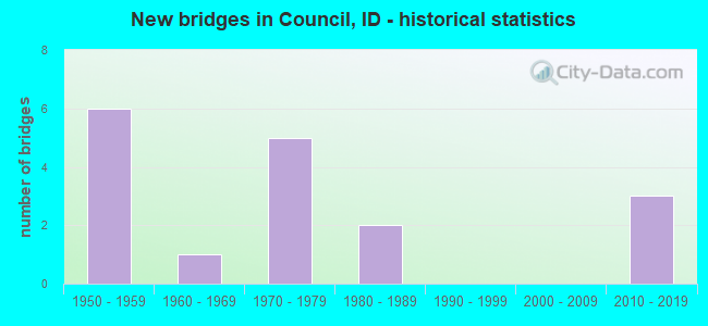
- New bridges - historical statistics
- 61950-1959
- 11960-1969
- 51970-1979
- 21980-1989
- 32010-2019

- Reconstructed bridges - Historical Statistics
- 11970-1979
- 01980-1989
- 11990-1999
- 22000-2009


- Bridge Condition - Deck
- 17.6%Very good
- 41.2%Good
- 29.4%Satisfactory
- 11.8%Fair

- Bridge Condition - Superstructure
- 23.5%Very good
- 29.4%Good
- 47.1%Satisfactory

- Bridge Condition - Substructure
- 11.8%Very good
- 17.6%Good
- 35.3%Satisfactory
- 23.5%Fair
- 11.8%Poor

- Bridge Condition - Channel
- 5.9%Excellent
- 23.5%Very good
- 29.4%Good
- 35.3%Satisfactory
- 5.9%Fair
Find on map >> Show street view
Structure Number: 152, Location: 2.4 NW. CAMBRIDGE (Lat: 44.582414, Lng: -116.727461), Route carried "on" structure: State highway 71, Year Built: 1958, Status: Open, Structure Length: 0.98m (3.22ft), Average Daily Traffic: 430 (year 2019), Truck Traffic: 7%, Average Future Daily Traffic: 645 (year 2039), Design Load: HS 20, Features Intersected: PINE CREEK
Minimum Vertical Clearance: 30+ m (98+ ft), Kilometerpoint: 41.964, Lanes on structure: 2, Owner: State Highway Agency, Approaching Roadway Width: 7.3m (24.0ft), Material/Design: Concrete, Design/Construction: Tee Beam, Number Of Spans In Main Unit: 1, Length of Maximum Span: 9.1m (29.9ft), Curb or Sidewalk Widths: Left: 0.2m (0.7ft), Right: 0.2m (0.7ft), Curb-To-Curb Width: 8.5m (27.9ft), Out-to-Out Width: 9.3m (30.5ft)
Condition: Deck: Satisfactory, Superstructure: Satisfactory, Substructure: Satisfactory, Channel: Good, Operating Rating: 43.5 metric tons, Method Used To Determine Operating Rating: Load Factor (LF), Inventory Rating: 26.3 metric tons, Method Used To Determine Inventory Rating: Load Factor (LF), Structural Evaluation: Equal to present minimum criteria, Deck Geometry: Somewhat better than minimum adequacy, Waterway Adequacy: Equal to present desirable criteria, Approach Roadway Alignment: Equal to present desirable criteria, Designated Inspection Frequency: Every 24 months, Inspection Date: July 2021, Deck Structure Type: Concrete Cast-file-Place, Wearing Surface/Protective System: Wearing Surface: Bituminous
Find on map >> Show street view
Structure Number: 18206, Location: 2.6 S. COUNCIL CL (Lat: 44.685750, Lng: -116.447806), Route carried "on" structure: US 95, Year Built: 2017, Status: Open, Structure Length: 1.74m (5.71ft), Average Daily Traffic: 2,500 (year 2019), Truck Traffic: 14%, Average Future Daily Traffic: 3,750 (year 2039), Design Load: HL 93, Features Intersected: COTTONWOOD CREEK
Minimum Vertical Clearance: 30+ m (98+ ft), Kilometerpoint: 213.547, Lanes on structure: 2, Base Highway Network: Yes, Owner: State Highway Agency, Approaching Roadway Width: 11.0m (36.1ft), Material/Design: Prestressed concrete, Design/Construction: Box Beam or Girders - Multiple, Number Of Spans In Main Unit: 1, Length of Maximum Span: 16.5m (54.1ft), Curb-To-Curb Width: 11.3m (37.1ft), Out-to-Out Width: 12.3m (40.4ft)
Condition: Deck: Very good, Superstructure: Very good, Substructure: Very good, Channel: Very good, Operating Rating: 47.0 metric tons, Method Used To Determine Operating Rating: Load and Resistance Factor Rating (LRFR) rating reported by rating factor(RF) method using HL-93 loadings, Inventory Rating: 36.3 metric tons, Method Used To Determine Inventory Rating: Load and Resistance Factor Rating (LRFR) rating reported by rating factor(RF) method using HL-93 loadings, Structural Evaluation: Equal to present desirable criteria, Deck Geometry: Somewhat better than minimum adequacy, Waterway Adequacy: Equal to present desirable criteria, Approach Roadway Alignment: Equal to present desirable criteria, Designated Inspection Frequency: Every 48 months, Inspection Date: September 2019, Deck Structure Type: Concrete Precast Panels, Wearing Surface/Protective System: Wearing Surface: Bituminous, Membrane: Other, Deck Protection: Epoxy Coated Reinforcing
Find on map >> Show street view
Structure Number: 18216, Location: 2.0 S. COUNCIL (Lat: 44.694667, Lng: -116.447778), Route carried "on" structure: US 95, Year Built: 2017, Status: Open, Structure Length: 0.79m (2.59ft), Average Daily Traffic: 2,500 (year 2019), Truck Traffic: 14%, Average Future Daily Traffic: 3,750 (year 2039), Design Load: HL 93, Features Intersected: LESTER CREEK
Minimum Vertical Clearance: 30+ m (98+ ft), Kilometerpoint: 214.532, Lanes on structure: 2, Base Highway Network: Yes (Inventory Route: US0, Subroute: 1), Owner: State Highway Agency, Approaching Roadway Width: 11.6m (38.1ft), Material/Design: Concrete, Design/Construction: Frame, Number Of Spans In Main Unit: 1, Length of Maximum Span: 7.3m (24.0ft), Curb-To-Curb Width: 12.4m (40.7ft), Out-to-Out Width: 13.4m (44.0ft)
Condition: Deck: Very good, Superstructure: Very good, Substructure: Very good, Channel: Very good, Operating Rating: 70.3 metric tons, Method Used To Determine Operating Rating: Load and Resistance Factor Rating (LRFR) rating reported by rating factor(RF) method using HL-93 loadings, Inventory Rating: 54.4 metric tons, Method Used To Determine Inventory Rating: Load and Resistance Factor Rating (LRFR) rating reported by rating factor(RF) method using HL-93 loadings, Structural Evaluation: Equal to present desirable criteria, Deck Geometry: Equal to present minimum criteria, Waterway Adequacy: Equal to present desirable criteria, Approach Roadway Alignment: Equal to present desirable criteria, Designated Inspection Frequency: Every 48 months, Inspection Date: September 2019, Deck Structure Type: Concrete Precast Panels, Wearing Surface/Protective System: Wearing Surface: Bituminous, Membrane: Other
Find on map >> Show street view
Structure Number: 2005, Location: 0.2 N. 0.5 W. COUNCIL (Lat: 44.731833, Lng: -116.449694), Route carried "on" structure: County highway 3894, Year Built: 1956, Status: Open, Structure Length: 3.66m (12.01ft), Average Daily Traffic: 210 (year 2019), Truck Traffic: 14%, Average Future Daily Traffic: 315 (year 2039), Design Load: HS 20, Features Intersected: WEISER RIVER;COUNCIL BR.
Minimum Vertical Clearance: 30+ m (98+ ft), Kilometerpoint: 1.159, Lanes on structure: 2, Owner: County Highway Agency, Approaching Roadway Width: 7.3m (24.0ft), Material/Design: Concrete, Design/Construction: Stringer/Multi-beam, Number Of Spans In Main Unit: 3, Length of Maximum Span: 12.2m (40.0ft), Curb-To-Curb Width: 7.9m (25.9ft), Out-to-Out Width: 9.1m (29.9ft)
Condition: Deck: Good, Superstructure: Satisfactory, Substructure: Satisfactory, Channel: Excellent, Operating Rating: 65.3 metric tons, Method Used To Determine Operating Rating: Load Factor (LF), Inventory Rating: 39.0 metric tons, Method Used To Determine Inventory Rating: Load Factor (LF), Structural Evaluation: Equal to present minimum criteria, Deck Geometry: Somewhat better than minimum adequacy, Waterway Adequacy: Equal to present desirable criteria, Approach Roadway Alignment: Better than present minimum criteria, Length Of Structure Improvement: 4.69m (15.39ft), Designated Inspection Frequency: Every 48 months, Inspection Date: September 2019, Bridge Improvement Cost: $864,000, Roadway Improvement Cost: $86,000, Total Project Cost: $1,296,000, Deck Structure Type: Concrete Cast-file-Place, Wearing Surface/Protective System: Wearing Surface: Monolithic Concrete
Find on map >> Show street view
Structure Number: 2267, Location: 2.5 S. 1.2 W. BLACKFOOT (Lat: 43.152722, Lng: -112.370750), Route carried "on" structure: County highway , Year Built: 1955, Year Reconstructed: 1983, Status: Open, Structure Length: 1.31m (4.30ft), Average Daily Traffic: 200 (year 2019), Truck Traffic: 10%, Average Future Daily Traffic: 300 (year 2039), Design Load: HS 20, Features Intersected: NORTH CANAL, Facility Carried by Structure: SANDY ROAD
Minimum Vertical Clearance: 30+ m (98+ ft), Kilometerpoint: 161.439, Lanes on structure: 2, Owner: County Highway Agency, Maintenance Responsibility: Bureau of Indian Affairs, Approaching Roadway Width: 6.1m (20.0ft), Skew: 5 degrees, Material/Design: Concrete continuous, Design/Construction: Slab, Number Of Spans In Main Unit: 2, Length of Maximum Span: 6.4m (21.0ft), Curb or Sidewalk Widths: Left: 0.3m (1.0ft), Right: 0.3m (1.0ft), Curb-To-Curb Width: 6.2m (20.3ft), Out-to-Out Width: 6.8m (22.3ft)
Condition: Deck: Satisfactory, Superstructure: Satisfactory, Substructure: Fair, Channel: Satisfactory, Operating Rating: 60.8 metric tons, Method Used To Determine Operating Rating: Load Factor (LF), Inventory Rating: 36.3 metric tons, Method Used To Determine Inventory Rating: Load Factor (LF), Structural Evaluation: Somewhat better than minimum adequacy, Deck Geometry: Meets minimum limits, Waterway Adequacy: Better than present minimum criteria, Approach Roadway Alignment: Equal to present desirable criteria, Length Of Structure Improvement: 1.52m (4.99ft), Designated Inspection Frequency: Every 24 months, Inspection Date: October 2020, Bridge Improvement Cost: $230,000, Roadway Improvement Cost: $23,000, Total Project Cost: $345,000, Deck Structure Type: Concrete Cast-file-Place, Wearing Surface/Protective System: Wearing Surface: Bituminous
Find on map >> Show street view
Structure Number: 22745, Location: 4.5 W. 0.2 N SPRINGFIELD (Lat: 43.083000, Lng: -112.771361), Route carried "on" structure: County highway , Year Built: 1974, Status: Open, Structure Length: 2.38m (7.81ft), Average Daily Traffic: 100 (year 2019), Truck Traffic: 10%, Average Future Daily Traffic: 150 (year 2039), Design Load: H 20, Features Intersected: HIGH LINE CANAL, Facility Carried by Structure: S 2400 W; ANDERSON
Minimum Vertical Clearance: 30+ m (98+ ft), Kilometerpoint: 45.063, Lanes on structure: 2, Owner: County Highway Agency, Approaching Roadway Width: 8.5m (27.9ft), Skew: 5 degrees, Material/Design: Prestressed concrete, Design/Construction: Tee Beam, Number Of Spans In Main Unit: 2, Length of Maximum Span: 11.3m (37.1ft), Curb or Sidewalk Widths: Left: 0.2m (0.7ft), Right: 0.2m (0.7ft), Curb-To-Curb Width: 8.6m (28.2ft), Out-to-Out Width: 9.2m (30.2ft)
Condition: Deck: Fair, Superstructure: Satisfactory, Substructure: Fair, Channel: Good, Operating Rating: 27.2 metric tons, Method Used To Determine Operating Rating: Field evaluation and documented engineering judgment, Inventory Rating: 16.3 metric tons, Method Used To Determine Inventory Rating: Field evaluation and documented engineering judgment, Structural Evaluation: Somewhat better than minimum adequacy, Deck Geometry: Better than present minimum criteria, Waterway Adequacy: Superior to present desirable criteria, Approach Roadway Alignment: Equal to present desirable criteria, Length Of Structure Improvement: 2.38m (7.81ft), Designated Inspection Frequency: Every 24 months, Inspection Date: March 2021, Bridge Improvement Cost: $390,000, Roadway Improvement Cost: $39,000, Total Project Cost: $585,000 ( Estimate for 2017), Deck Structure Type: Concrete Cast-file-Place, Wearing Surface/Protective System: Wearing Surface: Monolithic Concrete
Find on map >> Show street view
Structure Number: 2533, Location: 0.6 S. 0.8 W. BLISS (Lat: 42.915194, Lng: -114.965833), Route carried "on" structure: County highway , Year Built: 1977, Status: Open, Structure Length: 5.79m (19.00ft), Average Daily Traffic: 170 (year 2019), Average Future Daily Traffic: 255 (year 2039), Design Load: HS 20, Features Intersected: SNAKE RIVER;SW BLISS BR, Facility Carried by Structure: SHOESTRING ROAD
Minimum Vertical Clearance: 30+ m (98+ ft), Kilometerpoint: 171.780, Lanes on structure: 2, Owner: Local Agency, Approaching Roadway Width: 10.7m (35.1ft), Material/Design: Prestressed concrete, Design/Construction: Stringer/Multi-beam, Number Of Spans In Main Unit: 2, Length of Maximum Span: 36.0m (118.1ft), Curb-To-Curb Width: 8.7m (28.5ft), Out-to-Out Width: 9.7m (31.8ft)
Condition: Deck: Satisfactory, Superstructure: Good, Substructure: Fair, Channel: Fair, Operating Rating: 50.8 metric tons, Method Used To Determine Operating Rating: Load Factor (LF), Inventory Rating: 16.3 metric tons, Method Used To Determine Inventory Rating: Load Factor (LF), Structural Evaluation: Somewhat better than minimum adequacy, Deck Geometry: Equal to present minimum criteria, Waterway Adequacy: Superior to present desirable criteria, Approach Roadway Alignment: Better than present minimum criteria, Length Of Structure Improvement: 6.83m (22.41ft), Designated Inspection Frequency: Every 24 months, Underwater Inspection Frequency: Every 48 months, Inspection Date: June 2021, Underwater Inspection Date: September 2018, Bridge Improvement Cost: $1,035,000, Roadway Improvement Cost: $103,000, Total Project Cost: $1,552,000 ( Estimate for 2017), Deck Structure Type: Concrete Cast-file-Place, Wearing Surface/Protective System: Wearing Surface: Monolithic Concrete
Find on map >> Show street view
Structure Number: 26425, Location: 1.2 N. 2.2 W. COUNCIL (Lat: 44.746333, Lng: -116.483056), Route carried "on" structure: County highway , Year Built: 1971, Status: Open, Structure Length: 1.55m (5.09ft), Average Daily Traffic: 100 (year 2019), Truck Traffic: 10%, Average Future Daily Traffic: 150 (year 2039), Design Load: HS 20, Features Intersected: HORNET CREEK, Facility Carried by Structure: OLD HORNET ROAD
Minimum Vertical Clearance: 30+ m (98+ ft), Kilometerpoint: 161.071, Lanes on structure: 1, Owner: County Highway Agency, Approaching Roadway Width: 5.5m (18.0ft), Skew: 3 degrees, Material/Design: Steel, Design/Construction: Stringer/Multi-beam, Number Of Spans In Main Unit: 1, Length of Maximum Span: 14.8m (48.6ft), Curb or Sidewalk Widths: Left: 0.2m (0.7ft), Right: 0.2m (0.7ft), Curb-To-Curb Width: 4.2m (13.8ft), Out-to-Out Width: 4.6m (15.1ft)
Condition: Deck: Good, Superstructure: Good, Substructure: Satisfactory, Channel: Good, Operating Rating: 59.9 metric tons, Method Used To Determine Operating Rating: Load Factor (LF), Inventory Rating: 45.4 metric tons, Method Used To Determine Inventory Rating: Load Factor (LF), Structural Evaluation: Equal to present minimum criteria, Deck Geometry: Somewhat better than minimum adequacy, Waterway Adequacy: Better than present minimum criteria, Approach Roadway Alignment: Equal to present desirable criteria, Length Of Structure Improvement: 2.26m (7.41ft), Designated Inspection Frequency: Every 24 months, Inspection Date: August 2020, Bridge Improvement Cost: $342,000, Roadway Improvement Cost: $34,000, Total Project Cost: $513,000, Deck Structure Type: Wood or Timber, Wearing Surface/Protective System: Wearing Surface: Bituminous
Find on map >> Show street view
Structure Number: 26452, Location: 0.6 N 1.1 W COUNCIL (Lat: 44.752917, Lng: -116.459889), Route carried "on" structure: County highway , Year Built: 1982, Year Reconstructed: 2012, Status: Posted for load, Structure Length: 1.86m (6.10ft), Average Daily Traffic: 20 (year 2019), Truck Traffic: 40%, Average Future Daily Traffic: 30 (year 2039), Design Load: H 15, Features Intersected: WEISER RIVER, Facility Carried by Structure: AIRPORT RD
Minimum Vertical Clearance: 30+ m (98+ ft), Kilometerpoint: 160.899, Lanes on structure: 1, Owner: County Highway Agency, Approaching Roadway Width: 4.9m (16.1ft), Material/Design: Steel, Design/Construction: Stringer/Multi-beam, Number Of Spans In Main Unit: 1, Length of Maximum Span: 17.7m (58.1ft), Curb-To-Curb Width: 3.3m (10.8ft), Out-to-Out Width: 3.7m (12.1ft)
Condition: Deck: Good, Superstructure: Satisfactory, Substructure: Poor, Channel: Satisfactory, Operating Rating: 22.7 metric tons, Method Used To Determine Operating Rating: Load Factor (LF), Inventory Rating: 13.6 metric tons, Method Used To Determine Inventory Rating: Load Factor (LF), Structural Evaluation: Meets minimum limits, Deck Geometry: High priority of replacement, Waterway Adequacy: Better than present minimum criteria, Approach Roadway Alignment: High priority of corrective action, Bridge Posting: Required (Relationship of Operating Rating to Maximum Legal Load: 20.0 - 29.9% below), Length Of Structure Improvement: 2.68m (8.79ft), Designated Inspection Frequency: Every 12 months, Inspection Date: September 2021, Bridge Improvement Cost: $348,000, Roadway Improvement Cost: $35,000, Total Project Cost: $522,000 ( Estimate for 2016), Deck Structure Type: Corrugated Steel, Wearing Surface/Protective System: Wearing Surface: Gravel
Find on map >> Show street view
Structure Number: 26455, Location: 6.1 N. 0.5 W. COUNCIL (Lat: 44.817556, Lng: -116.449639), Route carried "on" structure: County highway , Year Built: 1950, Status: Open, Structure Length: 1.34m (4.40ft), Average Daily Traffic: 50 (year 2019), Truck Traffic: 40%, Average Future Daily Traffic: 75 (year 2039), Design Load: H 10, Features Intersected: WEISER RIVER, Facility Carried by Structure: WEST FORK ROAD
Minimum Vertical Clearance: 30+ m (98+ ft), Kilometerpoint: 161.515, Lanes on structure: 2, Owner: County Highway Agency, Approaching Roadway Width: 7.3m (24.0ft), Material/Design: Concrete, Design/Construction: Tee Beam, Number Of Spans In Main Unit: 1, Length of Maximum Span: 13.1m (43.0ft), Curb or Sidewalk Widths: Left: 0.2m (0.7ft), Right: 0.2m (0.7ft), Curb-To-Curb Width: 7.3m (24.0ft), Out-to-Out Width: 8.1m (26.6ft)
Condition: Deck: Good, Superstructure: Good, Substructure: Fair, Channel: Satisfactory, Operating Rating: 27.2 metric tons, Method Used To Determine Operating Rating: Field evaluation and documented engineering judgment, Inventory Rating: 16.3 metric tons, Method Used To Determine Inventory Rating: Field evaluation and documented engineering judgment, Structural Evaluation: Somewhat better than minimum adequacy, Deck Geometry: Equal to present minimum criteria, Waterway Adequacy: Equal to present desirable criteria, Approach Roadway Alignment: Better than present minimum criteria, Length Of Structure Improvement: 2.04m (6.69ft), Designated Inspection Frequency: Every 24 months, Inspection Date: September 2021, Bridge Improvement Cost: $332,000, Roadway Improvement Cost: $33,000, Total Project Cost: $498,000 ( Estimate for 2019), Deck Structure Type: Concrete Cast-file-Place, Wearing Surface/Protective System: Wearing Surface: Bituminous
Find on map >> Show street view
Structure Number: 26465, Location: 2.4 S. 1.0 W. COUNCIL (Lat: 44.693889, Lng: -116.459722), Route carried "on" structure: County highway , Year Built: 1955, Year Reconstructed: 2011, Status: Open, Structure Length: 0.82m (2.69ft), Average Daily Traffic: 50 (year 2019), Truck Traffic: 40%, Average Future Daily Traffic: 75 (year 2039), Design Load: HS 15, Features Intersected: COTTONWOOD CREEK, Facility Carried by Structure: JACKSON CREEK RD
Minimum Vertical Clearance: 30+ m (98+ ft), Kilometerpoint: 169.311, Lanes on structure: 2, Owner: County Highway Agency, Approaching Roadway Width: 4.9m (16.1ft), Material/Design: Steel, Design/Construction: Stringer/Multi-beam, Number Of Spans In Main Unit: 1, Length of Maximum Span: 7.6m (24.9ft), Curb or Sidewalk Widths: Left: 0.1m (0.3ft), Right: 0.1m (0.3ft), Curb-To-Curb Width: 5.8m (19.0ft), Out-to-Out Width: 6.1m (20.0ft)
Condition: Deck: Good, Superstructure: Good, Substructure: Good, Channel: Good, Operating Rating: 61.7 metric tons, Method Used To Determine Operating Rating: Load Factor (LF), Inventory Rating: 36.3 metric tons, Method Used To Determine Inventory Rating: Load Factor (LF), Structural Evaluation: Better than present minimum criteria, Deck Geometry: Meets minimum limits, Waterway Adequacy: Better than present minimum criteria, Approach Roadway Alignment: Better than present minimum criteria, Designated Inspection Frequency: Every 24 months, Inspection Date: September 2021, Deck Structure Type: Corrugated Steel, Wearing Surface/Protective System: Wearing Surface: Gravel
Find on map >> Show street view
Structure Number: 26468, Location: 3.3 S. 2.8 E. COUNCIL (Lat: 44.681083, Lng: -116.381833), Route carried "on" structure: County highway , Year Built: 2018, Status: Open, Structure Length: 1.10m (3.61ft), Average Daily Traffic: 70 (year 2019), Truck Traffic: 14%, Average Future Daily Traffic: 105 (year 2039), Design Load: HS 20, Features Intersected: COTTONWOOD CREEK, Facility Carried by Structure: COTTONWOOD ROAD
Minimum Vertical Clearance: 30+ m (98+ ft), Kilometerpoint: 5.613, Lanes on structure: 1, Owner: County Highway Agency, Approaching Roadway Width: 4.9m (16.1ft), Material/Design: Steel, Design/Construction: Stringer/Multi-beam, Number Of Spans In Main Unit: 1, Length of Maximum Span: 10.6m (34.8ft), Curb-To-Curb Width: 4.3m (14.1ft), Out-to-Out Width: 4.3m (14.1ft)
Condition: Deck: Very good, Superstructure: Very good, Substructure: Good, Channel: Satisfactory, Operating Rating: 46.3 metric tons, Method Used To Determine Operating Rating: Load Factor (LF), Inventory Rating: 27.2 metric tons, Method Used To Determine Inventory Rating: Load Factor (LF), Structural Evaluation: Equal to present minimum criteria, Deck Geometry: Equal to present minimum criteria, Waterway Adequacy: Better than present minimum criteria, Approach Roadway Alignment: Somewhat better than minimum adequacy, Length Of Structure Improvement: 1.10m (3.61ft), Designated Inspection Frequency: Every 24 months, Inspection Date: June 2020, Bridge Improvement Cost: $166,000, Roadway Improvement Cost: $17,000, Total Project Cost: $183,000 ( Estimate for 2020), Deck Structure Type: Corrugated Steel, Wearing Surface/Protective System: Wearing Surface: Wood or Timber
Find on map >> Show street view
Structure Number: 2649, Location: 2.6 S. 1.5 W. COUNCIL (Lat: 44.692111, Lng: -116.468472), Route carried "on" structure: County highway , Year Built: 1988, Status: Posted for load, Structure Length: 2.59m (8.50ft), Average Daily Traffic: 50 (year 2019), Truck Traffic: 40%, Average Future Daily Traffic: 75 (year 2039), Design Load: H 10, Features Intersected: WEISER RIVER, Facility Carried by Structure: JACKSON CREEK RD
Minimum Vertical Clearance: 30+ m (98+ ft), Kilometerpoint: 168.454, Lanes on structure: 1, Owner: County Highway Agency, Approaching Roadway Width: 3.0m (9.8ft), Material/Design: Steel, Design/Construction: Stringer/Multi-beam, Number Of Spans In Main Unit: 1, Length of Maximum Span: 24.7m (81.0ft), Curb-To-Curb Width: 4.9m (16.1ft), Out-to-Out Width: 5.3m (17.4ft)
Condition: Deck: Satisfactory, Superstructure: Satisfactory, Substructure: Poor, Channel: Satisfactory, Operating Rating: 21.6 metric tons, Method Used To Determine Operating Rating: Allowable Stress (AS), Inventory Rating: 10.8 metric tons, Method Used To Determine Inventory Rating: Allowable Stress (AS), Structural Evaluation: Meets minimum limits, Deck Geometry: High priority of corrective action, Waterway Adequacy: Equal to present minimum criteria, Approach Roadway Alignment: Equal to present minimum criteria, Bridge Posting: Required (Relationship of Operating Rating to Maximum Legal Load: 30.0 - 39.9% below), Length Of Structure Improvement: 3.38m (11.09ft), Designated Inspection Frequency: Every 12 months, Inspection Date: September 2021, Bridge Improvement Cost: $513,000, Roadway Improvement Cost: $51,000, Total Project Cost: $770,000 ( Estimate for 2019), Deck Structure Type: Steel plate, Wearing Surface/Protective System: Wearing Surface: Bituminous
Find on map >> Show street view
Structure Number: 26505, Location: 4.3 S. 2.0 W. COUNCIL (Lat: 44.665889, Lng: -116.478250), Route carried "on" structure: County highway , Year Built: 1977, Year Reconstructed: 1996, Status: Open, Structure Length: 0.94m (3.08ft), Average Daily Traffic: 10 (year 2019), Average Future Daily Traffic: 15 (year 2039), Design Load: HS 20, Features Intersected: M.FK.WEISER RIVER, Facility Carried by Structure: MIDDLE FORK ROAD
Minimum Vertical Clearance: 30+ m (98+ ft), Kilometerpoint: 160.924, Lanes on structure: 1, Owner: County Highway Agency, Approaching Roadway Width: 4.9m (16.1ft), Material/Design: Steel, Design/Construction: Stringer/Multi-beam, Number Of Spans In Main Unit: 1, Length of Maximum Span: 9.1m (29.9ft), Curb or Sidewalk Widths: Left: 0.1m (0.3ft), Right: 0.1m (0.3ft), Curb-To-Curb Width: 4.7m (15.4ft), Out-to-Out Width: 5.0m (16.4ft)
Condition: Deck: Good, Superstructure: Very good, Substructure: Good, Channel: Good, Operating Rating: 89.8 metric tons, Method Used To Determine Operating Rating: Load Factor (LF), Inventory Rating: 53.5 metric tons, Method Used To Determine Inventory Rating: Load Factor (LF), Structural Evaluation: Better than present minimum criteria, Deck Geometry: Better than present minimum criteria, Waterway Adequacy: Equal to present desirable criteria, Approach Roadway Alignment: Better than present minimum criteria, Designated Inspection Frequency: Every 48 months, Inspection Date: September 2021, Deck Structure Type: Corrugated Steel, Wearing Surface/Protective System: Wearing Surface: Gravel
Find on map >> Show street view
Structure Number: 26507, Location: 5.0 S. COUNCIL (Lat: 44.658444, Lng: -116.451889), Route carried "on" structure: County highway , Year Built: 1951, Status: Open, Structure Length: 1.89m (6.20ft), Average Daily Traffic: 10 (year 2019), Average Future Daily Traffic: 15 (year 2039), Design Load: HS 15, Features Intersected: M.FK.WEISER RIVER, Facility Carried by Structure: SHAW LANE
Minimum Vertical Clearance: 30+ m (98+ ft), Kilometerpoint: 161.589, Lanes on structure: 2, Owner: County Highway Agency, Approaching Roadway Width: 7.3m (24.0ft), Material/Design: Concrete, Design/Construction: Tee Beam, Number Of Spans In Main Unit: 1, Length of Maximum Span: 18.3m (60.0ft), Curb or Sidewalk Widths: Left: 0.4m (1.3ft), Right: 0.4m (1.3ft), Curb-To-Curb Width: 8.5m (27.9ft), Out-to-Out Width: 10.0m (32.8ft)
Condition: Deck: Good, Superstructure: Good, Substructure: Satisfactory, Channel: Very good, Operating Rating: 37.2 metric tons, Method Used To Determine Operating Rating: Load Factor (LF), Inventory Rating: 22.7 metric tons, Method Used To Determine Inventory Rating: Load Factor (LF), Structural Evaluation: Equal to present minimum criteria, Deck Geometry: Better than present minimum criteria, Waterway Adequacy: Superior to present desirable criteria, Approach Roadway Alignment: Equal to present desirable criteria, Length Of Structure Improvement: 2.62m (8.60ft), Designated Inspection Frequency: Every 24 months, Inspection Date: September 2020, Bridge Improvement Cost: $397,000, Roadway Improvement Cost: $40,000, Total Project Cost: $596,000 ( Estimate for 2018), Deck Structure Type: Concrete Cast-file-Place, Wearing Surface/Protective System: Wearing Surface: Bituminous
Find on map >> Show street view
Structure Number: 3298, Location: IN REXBURG;W.2ND N.ST (Lat: 43.830278, Lng: -111.794667), Route carried "on" structure: City street , Year Built: 1977, Status: Open, Structure Length: 1.04m (3.41ft), Average Daily Traffic: 260 (year 2019), Truck Traffic: 10%, Average Future Daily Traffic: 390 (year 2039), Design Load: HS 20, Features Intersected: REXBURG CANAL, Facility Carried by Structure: W. 2ND NORTH ST
Minimum Vertical Clearance: 30+ m (98+ ft), Kilometerpoint: 161.211, Lanes on structure: 2, Owner: City or Municipal Highway Agency, Approaching Roadway Width: 14.0m (45.9ft), Skew: 4 degrees, Material/Design: Concrete, Design/Construction: Frame, Number Of Spans In Main Unit: 1, Length of Maximum Span: 10.4m (34.1ft), Curb or Sidewalk Widths: Left: 0.9m (3.0ft), Right: 0.9m (3.0ft), Curb-To-Curb Width: 14.6m (47.9ft), Out-to-Out Width: 16.5m (54.1ft)
Condition: Deck: Satisfactory, Superstructure: Satisfactory, Substructure: Satisfactory, Channel: Very good, Operating Rating: 34.5 metric tons, Method Used To Determine Operating Rating: Field evaluation and documented engineering judgment, Inventory Rating: 20.9 metric tons, Method Used To Determine Inventory Rating: Field evaluation and documented engineering judgment, Structural Evaluation: Equal to present minimum criteria, Deck Geometry: Superior to present desirable criteria, Waterway Adequacy: Equal to present desirable criteria, Approach Roadway Alignment: Equal to present minimum criteria, Designated Inspection Frequency: Every 24 months, Inspection Date: April 2020, Deck Structure Type: Concrete Cast-file-Place, Wearing Surface/Protective System: Wearing Surface: Bituminous
Find on map >> Show street view
Structure Number: 4120100000121, Location: NO DATA ENTERED (Lat: 44.681097, Lng: -116.381839), Route carried "on" structure: Federal lands road 50199, Year Built: 1963, Status: Open, Structure Length: 0.91m (2.99ft), Average Daily Traffic: 50 (year 0000), Average Future Daily Traffic: 75 (year 2042), Features Intersected: COTTONWOOD CR
Minimum Vertical Clearance: 30+ m (98+ ft), Kilometerpoint: 5.600, Lanes on structure: 1, Owner: U.S. Forest Service, Approaching Roadway Width: 4.6m (15.1ft), Material/Design: Wood or Timber, Design/Construction: Stringer/Multi-beam, Number Of Spans In Main Unit: 1, Length of Maximum Span: 8.8m (28.9ft), Curb-To-Curb Width: 4.6m (15.1ft), Out-to-Out Width: 4.9m (16.1ft)
Condition: Deck: Fair, Superstructure: Satisfactory, Substructure: Satisfactory, Channel: Satisfactory, Operating Rating: 48.6 metric tons, Method Used To Determine Operating Rating: Load and Resistance Factor Rating (LRFR) rating reported by rating factor(RF) method using HL-93 loadings, Inventory Rating: 37.3 metric tons, Method Used To Determine Inventory Rating: Load and Resistance Factor Rating (LRFR) rating reported by rating factor(RF) method using HL-93 loadings, Structural Evaluation: Equal to present minimum criteria, Deck Geometry: Better than present minimum criteria, Waterway Adequacy: Superior to present desirable criteria, Approach Roadway Alignment: Equal to present minimum criteria, Designated Inspection Frequency: Every 24 months, Inspection Date: October 2020, Deck Structure Type: Wood or Timber, Wearing Surface/Protective System: Wearing Surface: Gravel