Bridge Statistics for Country Club, Missouri (MO)
Condition, Traffic, Stress, Structural Evaluation, Project Costs
- National Bridge Inventory (NBI) Statistics
- 25Number of bridges
- 371ft / 113mTotal length
- $222,000Total costs
- 106,294Total average daily traffic
- 29,096Total average daily truck traffic
- National Bridge Inventory (NBI) Registered Bridges for Country Club
- No street view available for this location
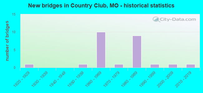
- New bridges - historical statistics
- 11920-1929
- 11950-1959
- 101960-1969
- 11970-1979
- 91980-1989
- 11990-1999
- 12000-2009
- 12010-2019

- Reconstructed bridges - Historical Statistics
- 21980-1989
- 01990-1999
- 12000-2009
- 22010-2019


- Bridge Condition - Deck
- 15.4%Very good
- 84.6%Good

- Bridge Condition - Superstructure
- 23.1%Very good
- 46.2%Good
- 23.1%Satisfactory
- 7.7%Fair

- Bridge Condition - Substructure
- 7.7%Excellent
- 53.8%Good
- 38.5%Satisfactory

- Bridge Condition - Channel
- 8.3%Very good
- 16.7%Good
- 75.0%Satisfactory

- Bridge Condition - Culverts
- 50.0%Satisfactory
- 50.0%Fair
Find on map >> Show street view
Structure Number: 1069, Location: S 4 T 59 N R 35 W (Lat: 39.871606, Lng: -94.832711), Route carried "on" structure: Interstate 29, Year Built: 1965, Year Reconstructed: 1991, Status: Open, Structure Length: 18.65m (61.19ft), Average Daily Traffic: 12,163 (year 2021), Truck Traffic: 34%, Average Future Daily Traffic: 25,542 (year 2041), Design Load: HS 20+Mod, Features Intersected: RT DD, ABANDONED RR, DIL
Minimum Vertical Clearance: 30+ m (98+ ft), Kilometerpoint: 110.754, Lanes on structure: 2, Lanes under structure: 2, Base Highway Network: Yes, Owner: State Highway Agency, Approaching Roadway Width: 11.6m (38.1ft), Skew: 25 degrees, Material/Design: Steel continuous, Design/Construction: Stringer/Multi-beam, Number Of Spans In Main Unit: 4, Number Of Approach Spans: 2, Length of Maximum Span: 41.4m (135.8ft), Curb-To-Curb Width: 9.8m (32.2ft), Out-to-Out Width: 10.5m (34.4ft)
Condition: Deck: Very good, Superstructure: Fair, Substructure: Good, Channel: Good, Operating Rating: 42.3 metric tons, Method Used To Determine Operating Rating: Load Factor (LF), Inventory Rating: 25.2 metric tons, Method Used To Determine Inventory Rating: Load Factor (LF), Structural Evaluation: Somewhat better than minimum adequacy, Deck Geometry: Meets minimum limits, Underclear: Superior to present desirable criteria, Waterway Adequacy: Equal to present desirable criteria, Approach Roadway Alignment: Equal to present desirable criteria, Designated Inspection Frequency: Every 24 months, Other Special Inspection Frequency: Every 24 months, Inspection Date: September 2018, Other Special Inspection Date: September 2018, Deck Structure Type: Concrete Cast-file-Place, Wearing Surface/Protective System: Wearing Surface: Monolithic Concrete, Deck Protection: Epoxy Coated Reinforcing
Find on map >> Show street view
Structure Number: 107, Location: S 4 T 58 N R 35 W (Lat: 39.871667, Lng: -94.832306), Route carried "on" structure: Interstate 29, Year Built: 1965, Year Reconstructed: 1991, Status: Open, Structure Length: 18.65m (61.19ft), Average Daily Traffic: 8,379 (year 2021), Truck Traffic: 36%, Average Future Daily Traffic: 17,596 (year 2041), Design Load: HS 20+Mod, Features Intersected: RT DD, ABANDONED RR, DIL
Minimum Vertical Clearance: 30+ m (98+ ft), Kilometerpoint: 96.242, Lanes on structure: 2, Lanes under structure: 2, Base Highway Network: Yes, Owner: State Highway Agency, Approaching Roadway Width: 11.6m (38.1ft), Skew: 25 degrees, Material/Design: Steel continuous, Design/Construction: Stringer/Multi-beam, Number Of Spans In Main Unit: 4, Number Of Approach Spans: 2, Length of Maximum Span: 41.4m (135.8ft), Curb-To-Curb Width: 9.8m (32.2ft), Out-to-Out Width: 10.5m (34.4ft)
Condition: Deck: Very good, Superstructure: Satisfactory, Substructure: Good, Channel: Satisfactory, Operating Rating: 42.3 metric tons, Method Used To Determine Operating Rating: Load Factor (LF), Inventory Rating: 25.2 metric tons, Method Used To Determine Inventory Rating: Load Factor (LF), Structural Evaluation: Equal to present minimum criteria, Deck Geometry: Meets minimum limits, Underclear: Superior to present desirable criteria, Waterway Adequacy: Equal to present desirable criteria, Approach Roadway Alignment: Equal to present desirable criteria, Designated Inspection Frequency: Every 24 months, Other Special Inspection Frequency: Every 24 months, Inspection Date: September 2018, Other Special Inspection Date: September 2018, Deck Structure Type: Concrete Cast-file-Place, Wearing Surface/Protective System: Wearing Surface: Epoxy Overlay
Find on map >> Show street view
Structure Number: 22539, Location: S 4 T 58 N R 35 W (Lat: 39.864772, Lng: -94.826633), Route carried "on" structure: County highway 361, Year Built: 1976, Status: Posted for load, Structure Length: 2.16m (7.09ft), Average Daily Traffic: 35 (year 2020), Truck Traffic: 10%, Average Future Daily Traffic: 40 (year 2040), Features Intersected: DILLON CR
Minimum Vertical Clearance: 30+ m (98+ ft), Kilometerpoint: 0.644, Lanes on structure: 2, Owner: County Highway Agency, Approaching Roadway Width: 5.5m (18.0ft), Material/Design: Steel, Design/Construction: Stringer/Multi-beam, Number Of Spans In Main Unit: 1, Number Of Approach Spans: 1, Length of Maximum Span: 13.7m (44.9ft), Curb-To-Curb Width: 5.8m (19.0ft), Out-to-Out Width: 6.2m (20.3ft)
Condition: Deck: Good, Superstructure: Good, Substructure: Good, Channel: Satisfactory, Operating Rating: 22.5 metric tons, Method Used To Determine Operating Rating: Allowable Stress (AS), Inventory Rating: 12.6 metric tons, Method Used To Determine Inventory Rating: Allowable Stress (AS), Structural Evaluation: Meets minimum limits, Deck Geometry: Meets minimum limits, Waterway Adequacy: Equal to present desirable criteria, Approach Roadway Alignment: High priority of corrective action, Bridge Posting: Required (Relationship of Operating Rating to Maximum Legal Load: 0.1 - 9.9% below), Length Of Structure Improvement: 0.30m (0.98ft), Designated Inspection Frequency: Every 24 months, Inspection Date: December 2021, Bridge Improvement Cost: $148,000, Roadway Improvement Cost: $15,000, Total Project Cost: $222,000 ( Estimate for 2022), Deck Structure Type: Concrete Cast-file-Place, Wearing Surface/Protective System: Wearing Surface: Monolithic Concrete
Find on map >> Show street view
Structure Number: 22754, Location: S 5 T 58 N R 35 W (Lat: 39.864683, Lng: -94.846294), Route carried "on" structure: County highway 372, Year Built: 1997, Status: Open, Structure Length: 0.88m (2.89ft), Average Daily Traffic: 30 (year 2020), Truck Traffic: 1%, Average Future Daily Traffic: 35 (year 2040), Design Load: HS 20, Features Intersected: CROWLEY CR
Minimum Vertical Clearance: 30+ m (98+ ft), Kilometerpoint: 4.506, Lanes on structure: 2, Owner: County Highway Agency, Approaching Roadway Width: 7.3m (24.0ft), Material/Design: Concrete, Design/Construction: Culvert, Number Of Spans In Main Unit: 1, Length of Maximum Span: 8.8m (28.9ft)
Condition: Channel: Satisfactory, Culverts: Satisfactory, Structural Evaluation: Equal to present minimum criteria, Waterway Adequacy: Superior to present desirable criteria, Approach Roadway Alignment: Equal to present desirable criteria, Designated Inspection Frequency: Every 24 months, Inspection Date: December 2021
Find on map >> Show street view
Structure Number: 2696, Location: S 5 T 58 N R 35 W (Lat: 39.871914, Lng: -94.857142), Route carried "on" structure: County highway 372, Year Built: 1985, Status: Open, Structure Length: 7.89m (25.89ft), Average Daily Traffic: 60 (year 2021), Truck Traffic: 10%, Average Future Daily Traffic: 78 (year 2041), Design Load: H 15, Features Intersected: IS 229
Minimum Vertical Clearance: 30+ m (98+ ft), Kilometerpoint: 2.898, Lanes on structure: 2, Lanes under structure: 4, Owner: State Highway Agency, Approaching Roadway Width: 8.5m (27.9ft), Material/Design: Steel continuous, Design/Construction: Stringer/Multi-beam, Number Of Spans In Main Unit: 2, Length of Maximum Span: 34.6m (113.5ft), Curb or Sidewalk Widths: Left: 0.2m (0.7ft), Right: 0.2m (0.7ft), Curb-To-Curb Width: 8.5m (27.9ft), Out-to-Out Width: 9.4m (30.8ft)
Condition: Deck: Good, Superstructure: Good, Substructure: Good, Operating Rating: 31.5 metric tons, Method Used To Determine Operating Rating: Allowable Stress (AS), Inventory Rating: 18.9 metric tons, Method Used To Determine Inventory Rating: Allowable Stress (AS), Structural Evaluation: Somewhat better than minimum adequacy, Deck Geometry: Better than present minimum criteria, Underclear: Somewhat better than minimum adequacy, Approach Roadway Alignment: Equal to present minimum criteria, Designated Inspection Frequency: Every 24 months, Inspection Date: September 2020, Deck Structure Type: Concrete Cast-file-Place, Wearing Surface/Protective System: Wearing Surface: Monolithic Concrete, Deck Protection: Epoxy Coated Reinforcing
Find on map >> Show street view
Structure Number: 30109, Location: S 8 T 58 N R 35 W (Lat: 39.862628, Lng: -94.843722), Route carried "on" structure: County highway 374, Year Built: 2004, Status: Open, Structure Length: 2.74m (8.99ft), Average Daily Traffic: 35 (year 2020), Truck Traffic: 10%, Average Future Daily Traffic: 40 (year 2040), Design Load: HS 20+Mod, Features Intersected: DILLON CR
Minimum Vertical Clearance: 30+ m (98+ ft), Kilometerpoint: 0.000, Lanes on structure: 2, Owner: County Highway Agency, Approaching Roadway Width: 7.3m (24.0ft), Skew: 2 degrees, Material/Design: Steel, Design/Construction: Stringer/Multi-beam, Number Of Spans In Main Unit: 1, Length of Maximum Span: 27.1m (88.9ft), Curb-To-Curb Width: 7.3m (24.0ft), Out-to-Out Width: 8.1m (26.6ft)
Condition: Deck: Good, Superstructure: Very good, Substructure: Excellent, Channel: Good, Operating Rating: 89.1 metric tons, Method Used To Determine Operating Rating: Load Factor (LF), Inventory Rating: 87.3 metric tons, Method Used To Determine Inventory Rating: Load Factor (LF), Structural Evaluation: Equal to present desirable criteria, Deck Geometry: Equal to present minimum criteria, Waterway Adequacy: Equal to present desirable criteria, Approach Roadway Alignment: Equal to present desirable criteria, Designated Inspection Frequency: Every 24 months, Inspection Date: December 2021, Deck Structure Type: Concrete Precast Panels, Wearing Surface/Protective System: Wearing Surface: Monolithic Concrete
Find on map >> Show street view
Structure Number: 33064, Location: S 4 T 58 N R 35 W (Lat: 39.867853, Lng: -94.834156), Route carried "on" structure: State highway DD, Year Built: 2010, Status: Open, Structure Length: 4.18m (13.71ft), Average Daily Traffic: 625 (year 2021), Truck Traffic: 13%, Average Future Daily Traffic: 813 (year 2041), Design Load: HS 20, Features Intersected: DILLON CR
Minimum Vertical Clearance: 30+ m (98+ ft), Kilometerpoint: 4.422, Lanes on structure: 2, Owner: State Highway Agency, Approaching Roadway Width: 7.3m (24.0ft), Skew: 3 degrees, Material/Design: Prestressed concrete, Design/Construction: Box Beam or Girders - Multiple, Number Of Spans In Main Unit: 3, Length of Maximum Span: 13.7m (44.9ft), Curb-To-Curb Width: 7.3m (24.0ft), Out-to-Out Width: 7.9m (25.9ft)
Condition: Deck: Good, Superstructure: Good, Substructure: Good, Channel: Very good, Operating Rating: 69.3 metric tons, Method Used To Determine Operating Rating: Load Factor (LF), Inventory Rating: 41.4 metric tons, Method Used To Determine Inventory Rating: Load Factor (LF), Structural Evaluation: Better than present minimum criteria, Deck Geometry: Meets minimum limits, Waterway Adequacy: Superior to present desirable criteria, Approach Roadway Alignment: Equal to present desirable criteria, Designated Inspection Frequency: Every 24 months, Inspection Date: September 2020, Deck Structure Type: Concrete Precast Panels, Wearing Surface/Protective System: Wearing Surface: Bituminous
Find on map >> Show street view
Structure Number: 3555, Location: S 12 T 58 N R 34 W (Lat: 39.858306, Lng: -94.768758), Route carried "on" structure: US 169, Year Built: 1985, Status: Open, Structure Length: 15.33m (50.30ft), Average Daily Traffic: 5,946 (year 2021), Truck Traffic: 8%, Average Future Daily Traffic: 8,027 (year 2041), Design Load: HS 20+Mod, Features Intersected: 102 RVR
Minimum Vertical Clearance: 30+ m (98+ ft), Kilometerpoint: 104.979, Lanes on structure: 2, Base Highway Network: Yes, Owner: State Highway Agency, Approaching Roadway Width: 13.4m (44.0ft), Skew: 2 degrees, Material/Design: Prestressed concrete continuous, Design/Construction: Stringer/Multi-beam, Number Of Spans In Main Unit: 6, Length of Maximum Span: 27.7m (90.9ft), Curb or Sidewalk Widths: Left: 0.2m (0.7ft), Right: 0.2m (0.7ft), Curb-To-Curb Width: 13.0m (42.7ft), Out-to-Out Width: 13.9m (45.6ft)
Condition: Deck: Good, Superstructure: Satisfactory, Substructure: Satisfactory, Channel: Satisfactory, Operating Rating: 63.9 metric tons, Method Used To Determine Operating Rating: Load Factor (LF), Inventory Rating: 42.3 metric tons, Method Used To Determine Inventory Rating: Load Factor (LF), Structural Evaluation: Equal to present minimum criteria, Deck Geometry: Somewhat better than minimum adequacy, Waterway Adequacy: Equal to present desirable criteria, Approach Roadway Alignment: Equal to present desirable criteria, Designated Inspection Frequency: Every 24 months, Inspection Date: September 2020, Deck Structure Type: Concrete Cast-file-Place, Wearing Surface/Protective System: Wearing Surface: Monolithic Concrete, Deck Protection: Epoxy Coated Reinforcing
Find on map >> Show street view
Structure Number: 4796, Location: S 14 T 58 N R 35 W (Lat: 39.841564, Lng: -94.792639), Route carried "on" structure: US 169, Year Built: 1924, Status: Open, Structure Length: 0.76m (2.49ft), Average Daily Traffic: 5,946 (year 2021), Truck Traffic: 8%, Average Future Daily Traffic: 8,027 (year 2041), Design Load: H 15, Features Intersected: FK OF 102 RVR
Minimum Vertical Clearance: 30+ m (98+ ft), Kilometerpoint: 108.142, Lanes on structure: 2, Base Highway Network: Yes, Owner: State Highway Agency, Approaching Roadway Width: 9.1m (29.9ft), Material/Design: Concrete continuous, Design/Construction: Culvert, Number Of Spans In Main Unit: 2, Length of Maximum Span: 3.7m (12.1ft), Curb-To-Curb Width: 10.3m (33.8ft), Out-to-Out Width: 10.9m (35.8ft)
Condition: Channel: Satisfactory, Culverts: Fair, Operating Rating: 90.0 metric tons, Method Used To Determine Operating Rating: Load Factor (LF), Inventory Rating: 54.0 metric tons, Method Used To Determine Inventory Rating: Load Factor (LF), Structural Evaluation: Somewhat better than minimum adequacy, Deck Geometry: Meets minimum limits, Waterway Adequacy: Equal to present minimum criteria, Approach Roadway Alignment: Better than present minimum criteria, Designated Inspection Frequency: Every 24 months, Inspection Date: November 2020
Find on map >> Show street view
Structure Number: 7059, Location: S 7 T 58 N R 34 W (Lat: 39.859997, Lng: -94.757319), Route carried "on" structure: State highway W, Year Built: 1958, Year Reconstructed: 2009, Status: Open, Structure Length: 3.84m (12.60ft), Average Daily Traffic: 867 (year 2021), Truck Traffic: 5%, Average Future Daily Traffic: 1,127 (year 2041), Design Load: H 10, Features Intersected: LONG BR
Minimum Vertical Clearance: 30+ m (98+ ft), Kilometerpoint: 0.336, Lanes on structure: 2, Owner: State Highway Agency, Approaching Roadway Width: 6.7m (22.0ft), Skew: 3 degrees, Material/Design: Steel, Design/Construction: Stringer/Multi-beam, Number Of Spans In Main Unit: 3, Length of Maximum Span: 15.1m (49.5ft), Curb-To-Curb Width: 6.7m (22.0ft), Out-to-Out Width: 7.5m (24.6ft)
Condition: Deck: Good, Superstructure: Satisfactory, Substructure: Satisfactory, Channel: Satisfactory, Operating Rating: 42.3 metric tons, Method Used To Determine Operating Rating: Load Factor (LF), Inventory Rating: 25.2 metric tons, Method Used To Determine Inventory Rating: Load Factor (LF), Structural Evaluation: Equal to present minimum criteria, Deck Geometry: Meets minimum limits, Waterway Adequacy: Equal to present minimum criteria, Approach Roadway Alignment: Equal to present minimum criteria, Designated Inspection Frequency: Every 24 months, Inspection Date: September 2020, Deck Structure Type: Concrete Cast-file-Place, Wearing Surface/Protective System: Wearing Surface: Monolithic Concrete, Deck Protection: Epoxy Coated Reinforcing
Find on map >> Show street view
Structure Number: 794, Location: S 10 T 58 N R 35 W (Lat: 39.858136, Lng: -94.810764), Route carried "on" structure: Business State highway 29, Year Built: 1962, Year Reconstructed: 2010, Status: Open, Structure Length: 7.92m (25.98ft), Average Daily Traffic: 5,123 (year 2021), Truck Traffic: 6%, Average Future Daily Traffic: 10,758 (year 2041), Design Load: H 20, Features Intersected: IS 29
Minimum Vertical Clearance: 30+ m (98+ ft), Kilometerpoint: 0.111, Lanes on structure: 2, Lanes under structure: 4, Base Highway Network: Yes, Owner: State Highway Agency, Approaching Roadway Width: 12.2m (40.0ft), Skew: 22 degrees, Material/Design: Steel continuous, Design/Construction: Stringer/Multi-beam, Number Of Spans In Main Unit: 4, Length of Maximum Span: 21.6m (70.9ft), Curb-To-Curb Width: 12.2m (40.0ft), Out-to-Out Width: 13.0m (42.7ft)
Condition: Deck: Good, Superstructure: Very good, Substructure: Good, Operating Rating: 54.9 metric tons, Method Used To Determine Operating Rating: Load Factor (LF), Inventory Rating: 33.3 metric tons, Method Used To Determine Inventory Rating: Load Factor (LF), Structural Evaluation: Better than present minimum criteria, Deck Geometry: Better than present minimum criteria, Underclear: Meets minimum limits, Approach Roadway Alignment: Equal to present desirable criteria, Designated Inspection Frequency: Every 24 months, Inspection Date: September 2020, Deck Structure Type: Concrete Cast-file-Place
Find on map >> Show street view
Structure Number: 795, Location: S 10 T 58 N R 35 W (Lat: 39.858000, Lng: -94.810494), Route carried "on" structure: US 59, Year Built: 1962, Year Reconstructed: 2010, Status: Open, Structure Length: 7.92m (25.98ft), Average Daily Traffic: 4,716 (year 2021), Truck Traffic: 4%, Average Future Daily Traffic: 9,904 (year 2041), Design Load: H 20, Features Intersected: IS 29
Minimum Vertical Clearance: 30+ m (98+ ft), Kilometerpoint: 48.396, Lanes on structure: 2, Lanes under structure: 4, Base Highway Network: Yes, Owner: State Highway Agency, Approaching Roadway Width: 12.2m (40.0ft), Skew: 22 degrees, Material/Design: Steel continuous, Design/Construction: Stringer/Multi-beam, Number Of Spans In Main Unit: 4, Length of Maximum Span: 21.6m (70.9ft), Curb-To-Curb Width: 12.2m (40.0ft), Out-to-Out Width: 13.0m (42.7ft)
Condition: Deck: Good, Superstructure: Very good, Substructure: Good, Operating Rating: 54.9 metric tons, Method Used To Determine Operating Rating: Load Factor (LF), Inventory Rating: 33.3 metric tons, Method Used To Determine Inventory Rating: Load Factor (LF), Structural Evaluation: Better than present minimum criteria, Deck Geometry: Better than present minimum criteria, Underclear: Meets minimum limits, Approach Roadway Alignment: Equal to present desirable criteria, Designated Inspection Frequency: Every 24 months, Inspection Date: September 2020, Deck Structure Type: Concrete Cast-file-Place, Wearing Surface/Protective System: Deck Protection: Epoxy Coated Reinforcing
Find on map >> Show street view
Structure Number: 943, Location: S 8 T 58 N R 35 W (Lat: 39.858228, Lng: -94.859117), Route carried "on" structure: Interstate 229, Year Built: 1985, Status: Open, Structure Length: 5.00m (16.40ft), Average Daily Traffic: 2,692 (year 2021), Truck Traffic: 28%, Average Future Daily Traffic: 5,653 (year 2041), Design Load: HS 20+Mod, Features Intersected: DILLON CR
Minimum Vertical Clearance: 30+ m (98+ ft), Kilometerpoint: 3.346, Lanes on structure: 2, Base Highway Network: Yes, Owner: State Highway Agency, Approaching Roadway Width: 12.2m (40.0ft), Skew: 12 degrees, Material/Design: Prestressed concrete continuous, Design/Construction: Stringer/Multi-beam, Number Of Spans In Main Unit: 3, Length of Maximum Span: 19.2m (63.0ft), Curb or Sidewalk Widths: Left: 0.2m (0.7ft), Right: 0.2m (0.7ft), Curb-To-Curb Width: 12.0m (39.4ft), Out-to-Out Width: 12.8m (42.0ft)
Condition: Deck: Good, Superstructure: Good, Substructure: Satisfactory, Channel: Satisfactory, Operating Rating: 67.5 metric tons, Method Used To Determine Operating Rating: Load Factor (LF), Inventory Rating: 36.0 metric tons, Method Used To Determine Inventory Rating: Load Factor (LF), Structural Evaluation: Equal to present minimum criteria, Deck Geometry: Equal to present minimum criteria, Waterway Adequacy: Equal to present desirable criteria, Approach Roadway Alignment: Equal to present desirable criteria, Designated Inspection Frequency: Every 24 months, Inspection Date: September 2020, Deck Structure Type: Concrete Cast-file-Place, Wearing Surface/Protective System: Wearing Surface: Monolithic Concrete, Deck Protection: Epoxy Coated Reinforcing
Find on map >> Show street view
Structure Number: 945, Location: S 8 T 58 N R 35 W (Lat: 39.852847, Lng: -94.861136), Route carried "on" structure: Interstate 229, Year Built: 1985, Status: Open, Structure Length: 8.56m (28.08ft), Average Daily Traffic: 2,692 (year 2021), Truck Traffic: 28%, Average Future Daily Traffic: 5,653 (year 2041), Design Load: HS 20+Mod, Features Intersected: CRD 375, GORE CR
Minimum Vertical Clearance: 30+ m (98+ ft), Kilometerpoint: 3.901, Lanes on structure: 2, Lanes under structure: 2, Base Highway Network: Yes, Owner: State Highway Agency, Approaching Roadway Width: 12.2m (40.0ft), Skew: 11 degrees, Material/Design: Prestressed concrete continuous, Design/Construction: Stringer/Multi-beam, Number Of Spans In Main Unit: 5, Length of Maximum Span: 18.9m (62.0ft), Curb or Sidewalk Widths: Left: 0.2m (0.7ft), Right: 0.2m (0.7ft), Curb-To-Curb Width: 12.0m (39.4ft), Out-to-Out Width: 12.8m (42.0ft)
Condition: Deck: Good, Superstructure: Good, Substructure: Satisfactory, Channel: Satisfactory, Operating Rating: 63.9 metric tons, Method Used To Determine Operating Rating: Load Factor (LF), Inventory Rating: 38.7 metric tons, Method Used To Determine Inventory Rating: Load Factor (LF), Structural Evaluation: Equal to present minimum criteria, Deck Geometry: Equal to present minimum criteria, Underclear: Equal to present desirable criteria, Waterway Adequacy: Equal to present desirable criteria, Approach Roadway Alignment: Equal to present desirable criteria, Designated Inspection Frequency: Every 24 months, Inspection Date: September 2020, Deck Structure Type: Concrete Cast-file-Place, Wearing Surface/Protective System: Wearing Surface: Monolithic Concrete, Deck Protection: Epoxy Coated Reinforcing
Find on map >> Show street view
Structure Number: 946, Location: S 8 T 58 N R 35 W (Lat: 39.852850, Lng: -94.860781), Route carried "on" structure: Interstate 229, Year Built: 1985, Status: Open, Structure Length: 8.56m (28.08ft), Average Daily Traffic: 1,792 (year 2021), Truck Traffic: 22%, Average Future Daily Traffic: 3,763 (year 2041), Design Load: HS 20+Mod, Features Intersected: CRD 375, GORE CR
Minimum Vertical Clearance: 30+ m (98+ ft), Kilometerpoint: 20.300, Lanes on structure: 2, Lanes under structure: 2, Base Highway Network: Yes, Owner: State Highway Agency, Approaching Roadway Width: 12.2m (40.0ft), Skew: 11 degrees, Material/Design: Prestressed concrete continuous, Design/Construction: Stringer/Multi-beam, Number Of Spans In Main Unit: 5, Length of Maximum Span: 18.9m (62.0ft), Curb or Sidewalk Widths: Left: 0.2m (0.7ft), Right: 0.2m (0.7ft), Curb-To-Curb Width: 12.0m (39.4ft), Out-to-Out Width: 12.8m (42.0ft)
Condition: Deck: Good, Superstructure: Good, Substructure: Satisfactory, Channel: Satisfactory, Operating Rating: 63.9 metric tons, Method Used To Determine Operating Rating: Load Factor (LF), Inventory Rating: 38.7 metric tons, Method Used To Determine Inventory Rating: Load Factor (LF), Structural Evaluation: Equal to present minimum criteria, Deck Geometry: Equal to present minimum criteria, Underclear: Equal to present desirable criteria, Waterway Adequacy: Equal to present desirable criteria, Approach Roadway Alignment: Equal to present desirable criteria, Designated Inspection Frequency: Every 24 months, Inspection Date: September 2020, Deck Structure Type: Concrete Cast-file-Place, Wearing Surface/Protective System: Wearing Surface: Monolithic Concrete, Deck Protection: Epoxy Coated Reinforcing
Find on map >> Show street view
Structure Number: 1069, Location: S 4 T 59 N R 35 W (Lat: 39.871606, Lng: -94.832711), Route carried "under" structure: State highway DD, Year Built: 1965, Structure Length: 0. m, Average Daily Traffic: 625 (year 2021), Truck Traffic: 7%, Features Intersected: RT DD, Facility Carried by Structure: IS 29 S
Minimum Vertical Clearance: 9.22m (30.25ft), Kilometerpoint: 7.351, Lanes on structure: 2, Lanes under structure: 2, Material/Design: Steel continuous, Design/Construction: Stringer/Multi-beam, Length of Maximum Span: 41.4m (135.8ft)
Find on map >> Show street view
Structure Number: 107, Location: S 4 T 58 N R 35 W (Lat: 39.871667, Lng: -94.832306), Route carried "under" structure: State highway DD, Year Built: 1965, Structure Length: 0. m, Average Daily Traffic: 625 (year 2021), Truck Traffic: 7%, Features Intersected: RT DD, Facility Carried by Structure: IS 29 N
Minimum Vertical Clearance: 8.36m (27.43ft), Kilometerpoint: 7.314, Lanes on structure: 2, Lanes under structure: 2, Material/Design: Steel continuous, Design/Construction: Stringer/Multi-beam, Length of Maximum Span: 41.4m (135.8ft)
Find on map >> Show street view
Structure Number: 2696, Location: S 5 T 58 N R 35 W (Lat: 39.871914, Lng: -94.857142), Route carried "under" structure: Interstate 229, Year Built: 1985, Structure Length: 0. m, Average Daily Traffic: 1,792 (year 2021), Truck Traffic: 22%, Features Intersected: IS 229, Facility Carried by Structure: 372 E
Minimum Vertical Clearance: 5.72m (18.77ft), Kilometerpoint: 22.455, Lanes on structure: 2, Lanes under structure: 2, Material/Design: Steel continuous, Design/Construction: Stringer/Multi-beam, Length of Maximum Span: 34.6m (113.5ft)
Find on map >> Show street view
Structure Number: 2696, Location: S 5 T 58 N R 35 W (Lat: 39.871914, Lng: -94.857142), Route carried "under" structure: Interstate 229, Year Built: 1985, Structure Length: 0. m, Average Daily Traffic: 2,692 (year 2021), Truck Traffic: 28%, Features Intersected: IS 229, Facility Carried by Structure: 372 E
Minimum Vertical Clearance: 4.98m (16.34ft), Kilometerpoint: 1.833, Lanes on structure: 2, Lanes under structure: 2, Material/Design: Steel continuous, Design/Construction: Stringer/Multi-beam, Length of Maximum Span: 34.6m (113.5ft)
Find on map >> Show street view
Structure Number: 794, Location: S 10 T 58 N R 35 W (Lat: 39.858136, Lng: -94.810764), Route carried "under" structure: Interstate 29, Year Built: 1962, Structure Length: 0. m, Average Daily Traffic: 12,163 (year 2021), Truck Traffic: 34%, Features Intersected: IS 29
Minimum Vertical Clearance: 4.85m (15.91ft), Kilometerpoint: 113.253, Lanes on structure: 2, Lanes under structure: 2, Material/Design: Steel continuous, Design/Construction: Stringer/Multi-beam, Length of Maximum Span: 21.6m (70.9ft)
Find on map >> Show street view
Structure Number: 794, Location: S 10 T 58 N R 35 W (Lat: 39.858136, Lng: -94.810764), Route carried "under" structure: Interstate 29, Year Built: 1962, Structure Length: 0. m, Average Daily Traffic: 12,062 (year 2021), Truck Traffic: 38%, Features Intersected: IS 29
Minimum Vertical Clearance: 5.16m (16.93ft), Kilometerpoint: 93.968, Lanes on structure: 2, Lanes under structure: 2, Material/Design: Steel continuous, Design/Construction: Stringer/Multi-beam, Length of Maximum Span: 21.6m (70.9ft)
Find on map >> Show street view
Structure Number: 795, Location: S 10 T 58 N R 35 W (Lat: 39.858000, Lng: -94.810494), Route carried "under" structure: Interstate 29, Year Built: 1962, Structure Length: 0. m, Average Daily Traffic: 12,062 (year 2021), Truck Traffic: 38%, Features Intersected: IS 29, Facility Carried by Structure: US 59 N
Minimum Vertical Clearance: 5.23m (17.16ft), Kilometerpoint: 93.938, Lanes on structure: 2, Lanes under structure: 2, Material/Design: Steel continuous, Design/Construction: Stringer/Multi-beam, Length of Maximum Span: 21.6m (70.9ft)
Find on map >> Show street view
Structure Number: 795, Location: S 10 T 58 N R 35 W (Lat: 39.858000, Lng: -94.810494), Route carried "under" structure: Interstate 29, Year Built: 1962, Structure Length: 0. m, Average Daily Traffic: 13,060 (year 2021), Truck Traffic: 30%, Features Intersected: IS 29, Facility Carried by Structure: US 59 N
Minimum Vertical Clearance: 4.90m (16.08ft), Kilometerpoint: 113.279, Lanes on structure: 2, Lanes under structure: 2, Material/Design: Steel continuous, Design/Construction: Stringer/Multi-beam, Length of Maximum Span: 21.6m (70.9ft)
Find on map >> Show street view
Structure Number: 945, Location: S 8 T 58 N R 35 W (Lat: 39.852847, Lng: -94.861136), Route carried "under" structure: County highway 375, Year Built: 1985, Structure Length: 0. m, Average Daily Traffic: 56 (year 2021), Truck Traffic: 11%, Features Intersected: CRD 375, Facility Carried by Structure: IS 229 S
Minimum Vertical Clearance: 7.65m (25.10ft), Kilometerpoint: 2.160, Lanes on structure: 2, Lanes under structure: 2, Material/Design: Prestressed concrete continuous, Design/Construction: Stringer/Multi-beam, Length of Maximum Span: 18.9m (62.0ft)
Find on map >> Show street view
Structure Number: 946, Location: S 8 T 58 N R 35 W (Lat: 39.852850, Lng: -94.860781), Route carried "under" structure: County highway 375, Year Built: 1985, Structure Length: 0. m, Average Daily Traffic: 56 (year 2021), Truck Traffic: 11%, Features Intersected: CRD 375, Facility Carried by Structure: IS 229 N
Minimum Vertical Clearance: 7.60m (24.93ft), Kilometerpoint: 2.184, Lanes on structure: 2, Lanes under structure: 2, Material/Design: Prestressed concrete continuous, Design/Construction: Stringer/Multi-beam, Length of Maximum Span: 18.9m (62.0ft)