Bridge Statistics for Courtland, Virginia (VA)
Condition, Traffic, Stress, Structural Evaluation, Project Costs
- National Bridge Inventory (NBI) Statistics
- 25Number of bridges
- 607ft / 185mTotal length
- $2,398,000Total costs
- 96,978Total average daily traffic
- 16,286Total average daily truck traffic
- National Bridge Inventory (NBI) Registered Bridges for Courtland
- No street view available for this location
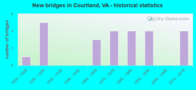
- New bridges - historical statistics
- 11920-1929
- 51930-1939
- 31960-1969
- 41970-1979
- 41980-1989
- 41990-1999
- 42010-2019

- Reconstructed bridges - Historical Statistics
- 11960-1969
- 01970-1979
- 11980-1989
- 11990-1999
- 22000-2009


- Bridge Condition - Deck
- 21.1%Very good
- 47.4%Good
- 31.6%Satisfactory

- Bridge Condition - Superstructure
- 21.1%Very good
- 31.6%Good
- 31.6%Satisfactory
- 10.5%Fair
- 5.3%Poor

- Bridge Condition - Substructure
- 15.8%Very good
- 21.1%Good
- 42.1%Satisfactory
- 21.1%Fair

- Bridge Condition - Channel
- 25.0%Very good
- 20.0%Good
- 35.0%Satisfactory
- 20.0%Fair

- Bridge Condition - Culverts
- 25.0%Good
- 75.0%Fair
Find on map >> Show street view
Structure Number: 5924, Location: 0.30 Fr 630 & 0.04 To 626 (Lat: 36.943997, Lng: -77.496331), Route carried "on" structure: State highway 40, Year Built: 1936, Status: Open, Structure Length: 2.97m (9.74ft), Average Daily Traffic: 1,091 (year 2020), Truck Traffic: 14%, Average Future Daily Traffic: 1,157 (year 2040), Design Load: H 15, Features Intersected: SAPPONY CREEK, Facility Carried by Structure: McKENNEY HIGHWAY
Minimum Vertical Clearance: 30+ m (98+ ft), Kilometerpoint: 306.695, Lanes on structure: 2, Owner: State Highway Agency, Approaching Roadway Width: 7.3m (24.0ft), Material/Design: Concrete, Design/Construction: Tee Beam, Number Of Spans In Main Unit: 3, Length of Maximum Span: 9.9m (32.5ft), Curb-To-Curb Width: 7.3m (24.0ft), Out-to-Out Width: 8.3m (27.2ft)
Condition: Deck: Good, Superstructure: Fair, Substructure: Fair, Channel: Satisfactory, Operating Rating: 46.6 metric tons, Method Used To Determine Operating Rating: Load Factor (LF), Inventory Rating: 27.9 metric tons, Method Used To Determine Inventory Rating: Load Factor (LF), Structural Evaluation: Somewhat better than minimum adequacy, Deck Geometry: Meets minimum limits, Waterway Adequacy: Equal to present minimum criteria, Approach Roadway Alignment: Equal to present desirable criteria, Length Of Structure Improvement: 2.99m (9.81ft), Designated Inspection Frequency: Every 24 months, Inspection Date: November 2021, Bridge Improvement Cost: $300,000, Roadway Improvement Cost: $50,000, Total Project Cost: $385,000, Deck Structure Type: Concrete Cast-file-Place, Wearing Surface/Protective System: Wearing Surface: Bituminous, Membrane: Preformed Fabric
Find on map >> Show street view
Structure Number: 16301, Location: 1.96MTO654&2.27M TO LEB (Lat: 36.888697, Lng: -82.098047), Route carried "on" structure: US 19, Year Built: 1985, Status: Open, Structure Length: 6.00m (19.69ft), Average Daily Traffic: 5,091 (year 2020), Truck Traffic: 5%, Average Future Daily Traffic: 7,129 (year 2040), Design Load: HS 20+Mod, Features Intersected: BUS 19 & ROUTE 660
Minimum Vertical Clearance: 30+ m (98+ ft), Kilometerpoint: 52.233, Lanes on structure: 3, Lanes under structure: 2, Base Highway Network: Yes, Owner: State Highway Agency, Approaching Roadway Width: 7.6m (24.9ft), Skew: 1 degrees, Material/Design: Steel, Design/Construction: Stringer/Multi-beam, Number Of Spans In Main Unit: 3, Length of Maximum Span: 33.8m (110.9ft), Curb-To-Curb Width: 11.7m (38.4ft), Out-to-Out Width: 12.7m (41.7ft)
Condition: Deck: Good, Superstructure: Good, Substructure: Good, Operating Rating: 79.8 metric tons, Method Used To Determine Operating Rating: Load and Resistance Factor (LRFR), Inventory Rating: 61.7 metric tons, Method Used To Determine Inventory Rating: Load and Resistance Factor (LRFR), Structural Evaluation: Better than present minimum criteria, Deck Geometry: High priority of corrective action, Underclear: Better than present minimum criteria, Approach Roadway Alignment: Equal to present desirable criteria, Length Of Structure Improvement: 6.00m (19.69ft), Designated Inspection Frequency: Every 24 months, Inspection Date: March 2020, Deck Structure Type: Concrete Cast-file-Place, Wearing Surface/Protective System: Deck Protection: Epoxy Coated Reinforcing
Find on map >> Show street view
Structure Number: 17721, Location: 4.30 mi to Int. Rte. 58 (Lat: 36.772639, Lng: -77.098892), Route carried "on" structure: State highway 35, Year Built: 1980, Status: Open, Structure Length: 7.44m (24.41ft), Average Daily Traffic: 2,632 (year 2020), Truck Traffic: 24%, Average Future Daily Traffic: 2,895 (year 2040), Design Load: HS 20+Mod, Features Intersected: Assamoosick Swamp, Facility Carried by Structure: Plank Road
Minimum Vertical Clearance: 30+ m (98+ ft), Kilometerpoint: 31.639, Lanes on structure: 2, Base Highway Network: Yes, Owner: State Highway Agency, Approaching Roadway Width: 9.1m (29.9ft), Material/Design: Steel, Design/Construction: Stringer/Multi-beam, Number Of Spans In Main Unit: 5, Length of Maximum Span: 15.2m (49.9ft), Curb-To-Curb Width: 11.7m (38.4ft), Out-to-Out Width: 12.7m (41.7ft)
Condition: Deck: Satisfactory, Superstructure: Fair, Substructure: Satisfactory, Channel: Fair, Operating Rating: 58.1 metric tons, Method Used To Determine Operating Rating: Load and Resistance Factor (LRFR), Inventory Rating: 44.5 metric tons, Method Used To Determine Inventory Rating: Load and Resistance Factor (LRFR), Structural Evaluation: Somewhat better than minimum adequacy, Deck Geometry: Somewhat better than minimum adequacy, Waterway Adequacy: Equal to present desirable criteria, Approach Roadway Alignment: Equal to present desirable criteria, Designated Inspection Frequency: Every 24 months, Inspection Date: April 2020, Deck Structure Type: Concrete Cast-file-Place, Wearing Surface/Protective System: Wearing Surface: Epoxy Overlay, Membrane: Epoxy
Find on map >> Show street view
Structure Number: 17722, Location: 0.50 Miles to Rte. 628 (Lat: 36.769758, Lng: -77.095000), Route carried "on" structure: State highway 35, Year Built: 1921, Year Reconstructed: 1998, Status: Open, Structure Length: 2.56m (8.40ft), Average Daily Traffic: 2,632 (year 2020), Truck Traffic: 24%, Average Future Daily Traffic: 2,895 (year 2040), Design Load: HS 20+Mod, Features Intersected: Mill Run, Facility Carried by Structure: Plank Road
Minimum Vertical Clearance: 30+ m (98+ ft), Kilometerpoint: 31.142, Lanes on structure: 2, Base Highway Network: Yes, Owner: State Highway Agency, Approaching Roadway Width: 12.8m (42.0ft), Material/Design: Steel, Design/Construction: Stringer/Multi-beam, Number Of Spans In Main Unit: 2, Length of Maximum Span: 12.8m (42.0ft), Curb-To-Curb Width: 12.2m (40.0ft), Out-to-Out Width: 13.2m (43.3ft)
Condition: Deck: Satisfactory, Superstructure: Good, Substructure: Satisfactory, Channel: Satisfactory, Operating Rating: 66.9 metric tons, Method Used To Determine Operating Rating: Load and Resistance Factor (LRFR), Inventory Rating: 51.6 metric tons, Method Used To Determine Inventory Rating: Load and Resistance Factor (LRFR), Structural Evaluation: Equal to present minimum criteria, Deck Geometry: Equal to present minimum criteria, Waterway Adequacy: Equal to present desirable criteria, Approach Roadway Alignment: Equal to present desirable criteria, Designated Inspection Frequency: Every 24 months, Inspection Date: April 2020, Deck Structure Type: Concrete Cast-file-Place, Wearing Surface/Protective System: Wearing Surface: Monolithic Concrete, Deck Protection: Epoxy Coated Reinforcing
Find on map >> Show street view
Structure Number: 17726, Location: 2.17 MI. TO INT. RTE. 58 (Lat: 36.747303, Lng: -77.080189), Route carried "on" structure: State highway 35, Year Built: 1932, Year Reconstructed: 1971, Status: Open, Structure Length: 0.61m (2.00ft), Average Daily Traffic: 3,122 (year 2020), Truck Traffic: 22%, Average Future Daily Traffic: 4,371 (year 2040), Features Intersected: Coscorie Branch, Facility Carried by Structure: Plank Road
Minimum Vertical Clearance: 30+ m (98+ ft), Kilometerpoint: 28.233, Lanes on structure: 2, Base Highway Network: Yes, Owner: State Highway Agency, Approaching Roadway Width: 8.3m (27.2ft), Material/Design: Concrete, Design/Construction: Slab, Number Of Spans In Main Unit: 1, Length of Maximum Span: 6.1m (20.0ft), Curb-To-Curb Width: 11.9m (39.0ft), Out-to-Out Width: 13.4m (44.0ft)
Condition: Deck: Satisfactory, Superstructure: Satisfactory, Substructure: Satisfactory, Channel: Satisfactory, Operating Rating: 43.0 metric tons, Method Used To Determine Operating Rating: Load and Resistance Factor (LRFR), Inventory Rating: 33.2 metric tons, Method Used To Determine Inventory Rating: Load and Resistance Factor (LRFR), Structural Evaluation: Equal to present minimum criteria, Deck Geometry: Somewhat better than minimum adequacy, Waterway Adequacy: Equal to present desirable criteria, Approach Roadway Alignment: Equal to present desirable criteria, Length Of Structure Improvement: 0.64m (2.10ft), Designated Inspection Frequency: Every 24 months, Inspection Date: September 2021, Bridge Improvement Cost: $40,000, Roadway Improvement Cost: $10,000, Total Project Cost: $68,000, Deck Structure Type: Concrete Cast-file-Place, Wearing Surface/Protective System: Wearing Surface: Bituminous
Find on map >> Show street view
Structure Number: 17728, Location: 1.60 MI. TO INT. RTE. 58 (Lat: 36.715164, Lng: -77.079003), Route carried "on" structure: US 35, Year Built: 1979, Status: Open, Structure Length: 1.22m (4.00ft), Average Daily Traffic: 3,534 (year 2020), Truck Traffic: 9%, Average Future Daily Traffic: 3,887 (year 2040), Design Load: HS 20, Features Intersected: Overflow Nottoway River, Facility Carried by Structure: Meherrin Road
Minimum Vertical Clearance: 30+ m (98+ ft), Kilometerpoint: 18.375, Lanes on structure: 2, Owner: State Highway Agency, Approaching Roadway Width: 7.7m (25.3ft), Material/Design: Steel, Design/Construction: Culvert, Number Of Spans In Main Unit: 4, Length of Maximum Span: 2.4m (7.9ft)
Condition: Channel: Good, Culverts: Fair, Operating Rating: 44.5 metric tons, Method Used To Determine Operating Rating: Load Factor (LF), Inventory Rating: 32.7 metric tons, Method Used To Determine Inventory Rating: Load Factor (LF), Structural Evaluation: Somewhat better than minimum adequacy, Waterway Adequacy: High priority of corrective action, Approach Roadway Alignment: Better than present minimum criteria, Designated Inspection Frequency: Every 24 months, Inspection Date: September 2021
Find on map >> Show street view
Structure Number: 17729, Location: 0.53 Mi. to Int. Rte. 611 (Lat: 36.683036, Lng: -77.014708), Route carried "on" structure: US 58, Year Built: 1930, Status: Open, Structure Length: 3.51m (11.52ft), Average Daily Traffic: 9,756 (year 2020), Truck Traffic: 16%, Average Future Daily Traffic: 13,658 (year 2040), Design Load: HS 20+Mod, Features Intersected: Nottoway Swamp
Minimum Vertical Clearance: 30+ m (98+ ft), Kilometerpoint: 708.570, Lanes on structure: 2, Base Highway Network: Yes, Owner: State Highway Agency, Approaching Roadway Width: 13.4m (44.0ft), Material/Design: Steel, Design/Construction: Stringer/Multi-beam, Number Of Spans In Main Unit: 3, Length of Maximum Span: 11.9m (39.0ft), Curb-To-Curb Width: 11.7m (38.4ft), Out-to-Out Width: 12.8m (42.0ft)
Condition: Deck: Satisfactory, Superstructure: Poor, Substructure: Fair, Channel: Satisfactory, Operating Rating: 36.0 metric tons, Method Used To Determine Operating Rating: Load and Resistance Factor (LRFR), Inventory Rating: 27.7 metric tons, Method Used To Determine Inventory Rating: Load and Resistance Factor (LRFR), Structural Evaluation: Meets minimum limits, Deck Geometry: Better than present minimum criteria, Waterway Adequacy: Equal to present desirable criteria, Approach Roadway Alignment: Equal to present desirable criteria, Length Of Structure Improvement: 3.66m (12.01ft), Designated Inspection Frequency: Every 12 months, Underwater Inspection Frequency: Every 42 months, Inspection Date: April 2021, Underwater Inspection Date: October 2019, Bridge Improvement Cost: $302,000, Roadway Improvement Cost: $40,000, Total Project Cost: $422,000, Deck Structure Type: Concrete Cast-file-Place, Wearing Surface/Protective System: Wearing Surface: Epoxy Overlay, Membrane: Epoxy
Find on map >> Show street view
Structure Number: 17739, Location: 0.05 miles from Route 650 (Lat: 36.683278, Lng: -77.014653), Route carried "on" structure: US 58, Year Built: 1966, Status: Open, Structure Length: 3.54m (11.61ft), Average Daily Traffic: 9,756 (year 2020), Truck Traffic: 16%, Average Future Daily Traffic: 13,658 (year 2040), Features Intersected: Nottoway Swamp
Minimum Vertical Clearance: 30+ m (98+ ft), Kilometerpoint: 708.682, Lanes on structure: 2, Base Highway Network: Yes, Owner: State Highway Agency, Approaching Roadway Width: 12.2m (40.0ft), Material/Design: Prestressed concrete, Design/Construction: Box Beam or Girders - Multiple, Number Of Spans In Main Unit: 3, Length of Maximum Span: 11.9m (39.0ft), Curb or Sidewalk Widths: Left: 0.5m (1.6ft), Right: 0.5m (1.6ft), Curb-To-Curb Width: 9.1m (29.9ft), Out-to-Out Width: 10.7m (35.1ft)
Condition: Deck: Satisfactory, Superstructure: Satisfactory, Substructure: Fair, Channel: Fair, Operating Rating: 47.8 metric tons, Method Used To Determine Operating Rating: Load and Resistance Factor (LRFR), Inventory Rating: 36.6 metric tons, Method Used To Determine Inventory Rating: Load and Resistance Factor (LRFR), Structural Evaluation: Somewhat better than minimum adequacy, Deck Geometry: Meets minimum limits, Waterway Adequacy: Better than present minimum criteria, Approach Roadway Alignment: Better than present minimum criteria, Length Of Structure Improvement: 3.66m (12.01ft), Designated Inspection Frequency: Every 24 months, Underwater Inspection Frequency: Every 42 months, Inspection Date: April 2021, Underwater Inspection Date: October 2019, Bridge Improvement Cost: $359,000, Roadway Improvement Cost: $40,000, Total Project Cost: $521,000 ( Estimate for 2018), Deck Structure Type: Concrete Cast-file-Place, Wearing Surface/Protective System: Wearing Surface: Bituminous
Find on map >> Show street view
Structure Number: 17749, Location: 1.80 TO 35 / 1.48 TO 742 (Lat: 36.693739, Lng: -77.070867), Route carried "on" structure: US 58, Year Built: 1984, Status: Open, Structure Length: 36.58m (120.01ft), Average Daily Traffic: 7,477 (year 2020), Truck Traffic: 21%, Average Future Daily Traffic: 10,468 (year 2040), Design Load: HS 20+Mod, Features Intersected: Nottoway River
Minimum Vertical Clearance: 30+ m (98+ ft), Kilometerpoint: 703.069, Lanes on structure: 2, Base Highway Network: Yes, Owner: State Highway Agency, Approaching Roadway Width: 12.2m (40.0ft), Skew: 3 degrees, Material/Design: Prestressed concrete, Design/Construction: Stringer/Multi-beam, Number Of Spans In Main Unit: 20, Length of Maximum Span: 18.3m (60.0ft), Curb-To-Curb Width: 11.7m (38.4ft), Out-to-Out Width: 12.7m (41.7ft)
Condition: Deck: Good, Superstructure: Satisfactory, Substructure: Satisfactory, Channel: Good, Operating Rating: 98.6 metric tons, Method Used To Determine Operating Rating: Load and Resistance Factor (LRFR), Inventory Rating: 68.7 metric tons, Method Used To Determine Inventory Rating: Load and Resistance Factor (LRFR), Structural Evaluation: Equal to present minimum criteria, Deck Geometry: Better than present minimum criteria, Waterway Adequacy: Equal to present desirable criteria, Approach Roadway Alignment: Equal to present desirable criteria, Length Of Structure Improvement: 36.58m (120.01ft), Designated Inspection Frequency: Every 24 months, Underwater Inspection Frequency: Every 60 months, Inspection Date: December 2020, Underwater Inspection Date: May 2020, Bridge Improvement Cost: $518,000, Roadway Improvement Cost: $30,000, Total Project Cost: $725,000 ( Estimate for 2018), Deck Structure Type: Concrete Precast Panels, Wearing Surface/Protective System: Wearing Surface: Bituminous, Deck Protection: Epoxy Coated Reinforcing
Find on map >> Show street view
Structure Number: 1775, Location: 1.63 MI. TO INT. RTE. 35 (Lat: 36.693853, Lng: -77.074206), Route carried "on" structure: US 58, Year Built: 1984, Status: Open, Structure Length: 7.38m (24.21ft), Average Daily Traffic: 14,954 (year 2020), Truck Traffic: 21%, Average Future Daily Traffic: 19,669 (year 2040), Design Load: HS 20+Mod, Features Intersected: Overflow Nottoway River
Minimum Vertical Clearance: 30+ m (98+ ft), Kilometerpoint: 702.763, Lanes on structure: 2, Base Highway Network: Yes, Owner: State Highway Agency, Approaching Roadway Width: 12.2m (40.0ft), Material/Design: Prestressed concrete, Design/Construction: Stringer/Multi-beam, Number Of Spans In Main Unit: 4, Length of Maximum Span: 18.3m (60.0ft), Curb-To-Curb Width: 11.7m (38.4ft), Out-to-Out Width: 12.7m (41.7ft)
Condition: Deck: Good, Superstructure: Satisfactory, Substructure: Satisfactory, Channel: Very good, Operating Rating: 95.9 metric tons, Method Used To Determine Operating Rating: Load and Resistance Factor (LRFR), Inventory Rating: 68.1 metric tons, Method Used To Determine Inventory Rating: Load and Resistance Factor (LRFR), Structural Evaluation: Equal to present minimum criteria, Deck Geometry: Somewhat better than minimum adequacy, Waterway Adequacy: Equal to present desirable criteria, Approach Roadway Alignment: Equal to present desirable criteria, Designated Inspection Frequency: Every 24 months, Inspection Date: September 2020, Deck Structure Type: Concrete Precast Panels, Wearing Surface/Protective System: Wearing Surface: Epoxy Overlay, Deck Protection: Epoxy Coated Reinforcing
Find on map >> Show street view
Structure Number: 17776, Location: 1.60 TO 58 / 0.47 TO 649 (Lat: 36.710256, Lng: -77.030639), Route carried "on" structure: County highway 611, Year Built: 1967, Year Reconstructed: 2008, Status: Open, Structure Length: 0.64m (2.10ft), Average Daily Traffic: 402 (year 2018), Average Future Daily Traffic: 446 (year 2040), Design Load: HS 20, Features Intersected: Flag Run, Facility Carried by Structure: Flaggy Run Road
Minimum Vertical Clearance: 30+ m (98+ ft), Kilometerpoint: 1.657, Lanes on structure: 2, Owner: State Highway Agency, Approaching Roadway Width: 5.8m (19.0ft), Material/Design: Steel, Design/Construction: Stringer/Multi-beam, Number Of Spans In Main Unit: 1, Length of Maximum Span: 5.8m (19.0ft), Curb-To-Curb Width: 7.3m (24.0ft), Out-to-Out Width: 7.9m (25.9ft)
Condition: Deck: Very good, Superstructure: Very good, Substructure: Good, Channel: Fair, Operating Rating: 45.4 metric tons, Method Used To Determine Operating Rating: Load and Resistance Factor (LRFR), Inventory Rating: 35.4 metric tons, Method Used To Determine Inventory Rating: Load and Resistance Factor (LRFR), Structural Evaluation: Better than present minimum criteria, Deck Geometry: Meets minimum limits, Waterway Adequacy: Better than present minimum criteria, Approach Roadway Alignment: Equal to present minimum criteria, Designated Inspection Frequency: Every 24 months, Inspection Date: March 2020, Deck Structure Type: Wood or Timber, Wearing Surface/Protective System: Wearing Surface: Gravel
Find on map >> Show street view
Structure Number: 17791, Location: 1.80 MI. TO INT. RTE. 35 (Lat: 36.747914, Lng: -77.062894), Route carried "on" structure: County highway 616, Year Built: 1976, Status: Open, Structure Length: 0.61m (2.00ft), Average Daily Traffic: 1,421 (year 2020), Truck Traffic: 9%, Average Future Daily Traffic: 1,563 (year 2040), Design Load: HS 20, Features Intersected: Coscorie Branch, Facility Carried by Structure: Ivor Road
Minimum Vertical Clearance: 30+ m (98+ ft), Kilometerpoint: 2.800, Lanes on structure: 2, Owner: State Highway Agency, Approaching Roadway Width: 7.3m (24.0ft), Material/Design: Steel, Design/Construction: Culvert, Number Of Spans In Main Unit: 3, Length of Maximum Span: 1.8m (5.9ft)
Condition: Channel: Satisfactory, Culverts: Fair, Operating Rating: 44.5 metric tons, Method Used To Determine Operating Rating: Load Factor (LF), Inventory Rating: 32.7 metric tons, Method Used To Determine Inventory Rating: Load Factor (LF), Structural Evaluation: Somewhat better than minimum adequacy, Waterway Adequacy: Equal to present desirable criteria, Approach Roadway Alignment: Better than present minimum criteria, Length Of Structure Improvement: 0.91m (2.99ft), Designated Inspection Frequency: Every 24 months, Inspection Date: August 2021, Bridge Improvement Cost: $73,000, Roadway Improvement Cost: $25,000, Total Project Cost: $110,000
Find on map >> Show street view
Structure Number: 17829, Location: 4.24 TO 35N 1.20TO 35S (Lat: 36.752622, Lng: -77.096414), Route carried "on" structure: County highway 647, Year Built: 1971, Status: Open, Structure Length: 4.42m (14.50ft), Average Daily Traffic: 113 (year 2018), Average Future Daily Traffic: 125 (year 2040), Design Load: HS 20+Mod, Features Intersected: Assamoosick Swamp, Facility Carried by Structure: River Road
Minimum Vertical Clearance: 30+ m (98+ ft), Kilometerpoint: 1.931, Lanes on structure: 2, Owner: State Highway Agency, Approaching Roadway Width: 5.7m (18.7ft), Material/Design: Steel, Design/Construction: Stringer/Multi-beam, Number Of Spans In Main Unit: 3, Length of Maximum Span: 14.9m (48.9ft), Curb-To-Curb Width: 7.9m (25.9ft), Out-to-Out Width: 9.1m (29.9ft)
Condition: Deck: Good, Superstructure: Good, Substructure: Satisfactory, Channel: Good, Operating Rating: 74.5 metric tons, Method Used To Determine Operating Rating: Load and Resistance Factor (LRFR), Inventory Rating: 57.4 metric tons, Method Used To Determine Inventory Rating: Load and Resistance Factor (LRFR), Structural Evaluation: Equal to present minimum criteria, Deck Geometry: Somewhat better than minimum adequacy, Waterway Adequacy: Equal to present desirable criteria, Approach Roadway Alignment: Equal to present desirable criteria, Designated Inspection Frequency: Every 24 months, Inspection Date: Febuary 2021, Deck Structure Type: Concrete Cast-file-Place, Wearing Surface/Protective System: Wearing Surface: Monolithic Concrete
Find on map >> Show street view
Structure Number: 1783, Location: 0.44 TO 35S 050035 N (Lat: 36.743689, Lng: -77.081850), Route carried "on" structure: County highway 647, Year Built: 1972, Status: Open, Structure Length: 0.61m (2.00ft), Average Daily Traffic: 113 (year 2018), Average Future Daily Traffic: 125 (year 2040), Design Load: HS 20, Features Intersected: Coscorie Branch, Facility Carried by Structure: River Road
Minimum Vertical Clearance: 30+ m (98+ ft), Kilometerpoint: 0.708, Lanes on structure: 2, Owner: State Highway Agency, Approaching Roadway Width: 4.3m (14.1ft), Skew: 2 degrees, Material/Design: Steel, Design/Construction: Culvert, Number Of Spans In Main Unit: 3, Length of Maximum Span: 1.8m (5.9ft)
Condition: Channel: Satisfactory, Culverts: Fair, Operating Rating: 44.5 metric tons, Method Used To Determine Operating Rating: Load Factor (LF), Inventory Rating: 32.7 metric tons, Method Used To Determine Inventory Rating: Load Factor (LF), Structural Evaluation: Somewhat better than minimum adequacy, Waterway Adequacy: Better than present minimum criteria, Approach Roadway Alignment: Equal to present desirable criteria, Designated Inspection Frequency: Every 24 months, Inspection Date: September 2021
Find on map >> Show street view
Structure Number: 17833, Location: 0.5 MI. TO INT. RTE. 58 (Lat: 36.689994, Lng: -77.017025), Route carried "on" structure: County highway 650, Year Built: 1932, Year Reconstructed: 2005, Status: Open, Structure Length: 1.25m (4.10ft), Average Daily Traffic: 943 (year 2018), Average Future Daily Traffic: 1,100 (year 2040), Features Intersected: Flag Run, Facility Carried by Structure: Storys Station Rd
Minimum Vertical Clearance: 30+ m (98+ ft), Kilometerpoint: 6.312, Lanes on structure: 2, Owner: State Highway Agency, Approaching Roadway Width: 5.3m (17.4ft), Material/Design: Steel, Design/Construction: Stringer/Multi-beam, Number Of Spans In Main Unit: 1, Length of Maximum Span: 12.5m (41.0ft), Curb-To-Curb Width: 6.4m (21.0ft), Out-to-Out Width: 7.2m (23.6ft)
Condition: Deck: Good, Superstructure: Good, Substructure: Good, Channel: Very good, Operating Rating: 54.9 metric tons, Method Used To Determine Operating Rating: Load Factor (LF), Inventory Rating: 32.8 metric tons, Method Used To Determine Inventory Rating: Load Factor (LF), Structural Evaluation: Better than present minimum criteria, Deck Geometry: High priority of corrective action, Waterway Adequacy: Better than present minimum criteria, Approach Roadway Alignment: Better than present minimum criteria, Length Of Structure Improvement: 1.52m (4.99ft), Designated Inspection Frequency: Every 24 months, Inspection Date: May 2020, Bridge Improvement Cost: $111,000, Roadway Improvement Cost: $11,000, Total Project Cost: $167,000 ( Estimate for 2014), Deck Structure Type: Wood or Timber, Wearing Surface/Protective System: Wearing Surface: Bituminous
Find on map >> Show street view
Structure Number: 17899, Location: 1.40 mi. to Int. Rte. 675 (Lat: 36.673622, Lng: -77.082264), Route carried "on" structure: County highway 731, Year Built: 1968, Status: Open, Structure Length: 0.98m (3.22ft), Average Daily Traffic: 136 (year 2018), Average Future Daily Traffic: 151 (year 2040), Design Load: HS 20, Features Intersected: Mill Swamp, Facility Carried by Structure: Ridley Road
Minimum Vertical Clearance: 30+ m (98+ ft), Kilometerpoint: 1.931, Lanes on structure: 2, Owner: State Highway Agency, Approaching Roadway Width: 5.2m (17.1ft), Material/Design: Concrete, Design/Construction: Culvert, Number Of Spans In Main Unit: 3, Length of Maximum Span: 3.0m (9.8ft)
Condition: Channel: Fair, Culverts: Good, Operating Rating: 53.7 metric tons, Method Used To Determine Operating Rating: Load Factor (LF), Inventory Rating: 32.1 metric tons, Method Used To Determine Inventory Rating: Load Factor (LF), Structural Evaluation: Better than present minimum criteria, Waterway Adequacy: Equal to present desirable criteria, Approach Roadway Alignment: Equal to present desirable criteria, Designated Inspection Frequency: Every 24 months, Inspection Date: March 2020
Find on map >> Show street view
Structure Number: 19323, Location: 1.62 FR. 640; 3.9 TO 649 (Lat: 37.023467, Lng: -82.501811), Route carried "on" structure: State highway 72, Year Built: 1935, Year Reconstructed: 1991, Status: Open, Structure Length: 2.01m (6.59ft), Average Daily Traffic: 541 (year 2020), Truck Traffic: 14%, Average Future Daily Traffic: 595 (year 2040), Design Load: HS 20+Mod, Features Intersected: CRANES NEST RIVER, Facility Carried by Structure: CRANES NEST ROAD
Minimum Vertical Clearance: 30+ m (98+ ft), Kilometerpoint: 62.395, Lanes on structure: 2, Base Highway Network: Yes, Owner: State Highway Agency, Approaching Roadway Width: 7.0m (23.0ft), Skew: 3 degrees, Material/Design: Steel, Design/Construction: Stringer/Multi-beam, Number Of Spans In Main Unit: 1, Length of Maximum Span: 19.5m (64.0ft), Curb-To-Curb Width: 7.6m (24.9ft), Out-to-Out Width: 8.2m (26.9ft)
Condition: Deck: Satisfactory, Superstructure: Satisfactory, Substructure: Satisfactory, Channel: Satisfactory, Operating Rating: 60.8 metric tons, Method Used To Determine Operating Rating: Load and Resistance Factor (LRFR), Inventory Rating: 47.2 metric tons, Method Used To Determine Inventory Rating: Load and Resistance Factor (LRFR), Structural Evaluation: Equal to present minimum criteria, Deck Geometry: Meets minimum limits, Waterway Adequacy: Equal to present desirable criteria, Approach Roadway Alignment: Equal to present minimum criteria, Length Of Structure Improvement: 1.83m (6.00ft), Designated Inspection Frequency: Every 24 months, Inspection Date: January 2022, Deck Structure Type: Concrete Cast-file-Place
Find on map >> Show street view
Structure Number: 23609, Location: 1.80 MI. TO INT. RTE. 35 (Lat: 36.693881, Lng: -77.070950), Route carried "on" structure: Bypass US 58, Year Built: 1993, Status: Open, Structure Length: 36.58m (120.01ft), Average Daily Traffic: 7,477 (year 2020), Truck Traffic: 21%, Average Future Daily Traffic: 10,468 (year 2040), Design Load: HS 20+Mod, Features Intersected: Nottoway River
Minimum Vertical Clearance: 30+ m (98+ ft), Kilometerpoint: 703.069, Lanes on structure: 2, Base Highway Network: Yes, Owner: State Highway Agency, Approaching Roadway Width: 12.2m (40.0ft), Skew: 3 degrees, Material/Design: Prestressed concrete, Design/Construction: Stringer/Multi-beam, Number Of Spans In Main Unit: 20, Length of Maximum Span: 18.3m (60.0ft), Curb-To-Curb Width: 11.7m (38.4ft), Out-to-Out Width: 12.7m (41.7ft)
Condition: Deck: Very good, Superstructure: Satisfactory, Substructure: Fair, Channel: Good, Operating Rating: 96.3 metric tons, Method Used To Determine Operating Rating: Load and Resistance Factor (LRFR), Inventory Rating: 68.9 metric tons, Method Used To Determine Inventory Rating: Load and Resistance Factor (LRFR), Structural Evaluation: Somewhat better than minimum adequacy, Deck Geometry: Better than present minimum criteria, Waterway Adequacy: Equal to present desirable criteria, Approach Roadway Alignment: Equal to present desirable criteria, Designated Inspection Frequency: Every 24 months, Underwater Inspection Frequency: Every 60 months, Inspection Date: November 2021, Underwater Inspection Date: May 2020, Deck Structure Type: Concrete Precast Panels, Wearing Surface/Protective System: Wearing Surface: Monolithic Concrete, Deck Protection: Epoxy Coated Reinforcing
Find on map >> Show street view
Structure Number: 2363, Location: 1.50 MI. TO INT. RTE. 35 (Lat: 36.693992, Lng: -77.074186), Route carried "on" structure: US 58, Year Built: 1993, Status: Open, Structure Length: 7.38m (24.21ft), Average Daily Traffic: 7,477 (year 2020), Truck Traffic: 21%, Average Future Daily Traffic: 10,468 (year 2040), Design Load: HS 20+Mod, Features Intersected: Overflow Nottoway River
Minimum Vertical Clearance: 30+ m (98+ ft), Kilometerpoint: 702.763, Lanes on structure: 2, Base Highway Network: Yes, Owner: State Highway Agency, Approaching Roadway Width: 12.2m (40.0ft), Material/Design: Prestressed concrete, Design/Construction: Stringer/Multi-beam, Number Of Spans In Main Unit: 4, Length of Maximum Span: 18.3m (60.0ft), Curb-To-Curb Width: 11.7m (38.4ft), Out-to-Out Width: 12.7m (41.7ft)
Condition: Deck: Good, Superstructure: Good, Substructure: Satisfactory, Channel: Very good, Operating Rating: 95.0 metric tons, Method Used To Determine Operating Rating: Load and Resistance Factor (LRFR), Inventory Rating: 73.3 metric tons, Method Used To Determine Inventory Rating: Load and Resistance Factor (LRFR), Structural Evaluation: Equal to present minimum criteria, Deck Geometry: Better than present minimum criteria, Waterway Adequacy: Equal to present desirable criteria, Approach Roadway Alignment: Equal to present desirable criteria, Designated Inspection Frequency: Every 24 months, Inspection Date: April 2021, Deck Structure Type: Concrete Cast-file-Place, Wearing Surface/Protective System: Wearing Surface: Epoxy Overlay, Deck Protection: Epoxy Coated Reinforcing
Find on map >> Show street view
Structure Number: 24961, Location: 2.10 MI. RTE. RTE. 58 BUS (Lat: 36.700497, Lng: -77.099694), Route carried "on" structure: State highway 35, Year Built: 1997, Status: Open, Structure Length: 7.89m (25.89ft), Average Daily Traffic: 3,534 (year 2020), Truck Traffic: 9%, Average Future Daily Traffic: 3,887 (year 2040), Design Load: HS 20+Mod, Features Intersected: Route 58, Facility Carried by Structure: Meherrin Road
Minimum Vertical Clearance: 30+ m (98+ ft), Kilometerpoint: 20.885, Lanes on structure: 3, Lanes under structure: 4, Owner: State Highway Agency, Approaching Roadway Width: 17.4m (57.1ft), Skew: 2 degrees, Material/Design: Steel, Design/Construction: Stringer/Multi-beam, Number Of Spans In Main Unit: 2, Length of Maximum Span: 40.8m (133.9ft), Curb-To-Curb Width: 17.0m (55.8ft), Out-to-Out Width: 18.1m (59.4ft)
Condition: Deck: Good, Superstructure: Good, Substructure: Good, Operating Rating: 72.5 metric tons, Method Used To Determine Operating Rating: Load and Resistance Factor (LRFR), Inventory Rating: 55.8 metric tons, Method Used To Determine Inventory Rating: Load and Resistance Factor (LRFR), Structural Evaluation: Better than present minimum criteria, Deck Geometry: Superior to present desirable criteria, Underclear: Somewhat better than minimum adequacy, Approach Roadway Alignment: Equal to present desirable criteria, Designated Inspection Frequency: Every 24 months, Inspection Date: May 2021, Deck Structure Type: Concrete Cast-file-Place, Wearing Surface/Protective System: Wearing Surface: Monolithic Concrete, Deck Protection: Epoxy Coated Reinforcing
Find on map >> Show street view
Structure Number: 29902, Location: 0.08 mi fr WCL Courtland (Lat: 36.716444, Lng: -77.073833), Route carried "on" structure: State highway 35, Year Built: 2015, Status: Open, Structure Length: 27.50m (90.22ft), Average Daily Traffic: 3,534 (year 2020), Truck Traffic: 9%, Average Future Daily Traffic: 3,887 (year 2040), Design Load: HS 20+Mod, Features Intersected: Nottoway River, Facility Carried by Structure: Meherrin Road
Minimum Vertical Clearance: 30+ m (98+ ft), Kilometerpoint: 2.865, Lanes on structure: 2, Owner: State Highway Agency, Approaching Roadway Width: 12.2m (40.0ft), Material/Design: Concrete continuous, Design/Construction: Stringer/Multi-beam, Number Of Spans In Main Unit: 10, Length of Maximum Span: 28.3m (92.8ft), Curb-To-Curb Width: 12.2m (40.0ft), Out-to-Out Width: 12.7m (41.7ft)
Condition: Deck: Good, Superstructure: Very good, Substructure: Very good, Channel: Very good, Operating Rating: 75.4 metric tons, Method Used To Determine Operating Rating: Load and Resistance Factor (LRFR), Inventory Rating: 54.2 metric tons, Method Used To Determine Inventory Rating: Load and Resistance Factor (LRFR), Structural Evaluation: Equal to present desirable criteria, Deck Geometry: Equal to present minimum criteria, Waterway Adequacy: Equal to present desirable criteria, Approach Roadway Alignment: Equal to present desirable criteria, Designated Inspection Frequency: Every 24 months, Underwater Inspection Frequency: Every 60 months, Inspection Date: September 2021, Underwater Inspection Date: October 2020, Deck Structure Type: Concrete Cast-file-Place, Wearing Surface/Protective System: Wearing Surface: Monolithic Concrete, Deck Protection: Other Coated Reinforcing
Find on map >> Show street view
Structure Number: 29988, Location: 0.2Mito58bus/3.2MifrRte35 (Lat: 36.694517, Lng: -77.044128), Route carried "on" structure: County highway 742, Year Built: 2018, Status: Open, Structure Length: 6.83m (22.41ft), Average Daily Traffic: 1,012 (year 2018), Average Future Daily Traffic: 1,457 (year 2040), Design Load: HL 93, Features Intersected: Route 58, Facility Carried by Structure: Old Bridge Rd.
Minimum Vertical Clearance: 5.43m (17.81ft), Kilometerpoint: 2.768, Lanes on structure: 2, Lanes under structure: 6, Owner: State Highway Agency, Approaching Roadway Width: 12.2m (40.0ft), Skew: 1 degrees, Material/Design: Prestressed concrete continuous, Design/Construction: Stringer/Multi-beam, Number Of Spans In Main Unit: 2, Length of Maximum Span: 34.1m (111.9ft), Curb-To-Curb Width: 12.2m (40.0ft), Out-to-Out Width: 13.2m (43.3ft)
Condition: Deck: Very good, Superstructure: Very good, Substructure: Very good, Operating Rating: 79.3 metric tons, Method Used To Determine Operating Rating: Load and Resistance Factor (LRFR), Inventory Rating: 56.1 metric tons, Method Used To Determine Inventory Rating: Load and Resistance Factor (LRFR), Structural Evaluation: Equal to present desirable criteria, Underclear: High priority of corrective action, Approach Roadway Alignment: Equal to present minimum criteria, Designated Inspection Frequency: Every 24 months, Inspection Date: May 2020, Deck Structure Type: Concrete Cast-file-Place
Find on map >> Show street view
Structure Number: 29989, Location: .2Mifr58Bus/.9MitoGrnLkDr (Lat: 36.691522, Lng: -77.041058), Route carried "on" structure: State highway 742, Year Built: 2018, Status: Open, Structure Length: 16.00m (52.49ft), Average Daily Traffic: 230 (year 2016), Truck Traffic: 3%, Average Future Daily Traffic: 250 (year 2035), Design Load: HL 93, Features Intersected: Wetlands, Facility Carried by Structure: Old Bridge Rd
Minimum Vertical Clearance: 30+ m (98+ ft), Kilometerpoint: 0.000, Lanes on structure: 2, Owner: State Highway Agency, Approaching Roadway Width: 9.2m (30.2ft), Material/Design: Prestressed concrete continuous, Design/Construction: Stringer/Multi-beam, Number Of Spans In Main Unit: 5, Length of Maximum Span: 32.0m (105.0ft), Curb-To-Curb Width: 9.2m (30.2ft), Out-to-Out Width: 9.8m (32.2ft)
Condition: Deck: Very good, Superstructure: Very good, Substructure: Very good, Channel: Very good, Operating Rating: 69.1 metric tons, Method Used To Determine Operating Rating: Load and Resistance Factor (LRFR), Inventory Rating: 52.4 metric tons, Method Used To Determine Inventory Rating: Load and Resistance Factor (LRFR), Structural Evaluation: Equal to present desirable criteria, Deck Geometry: Equal to present minimum criteria, Waterway Adequacy: Superior to present desirable criteria, Approach Roadway Alignment: Equal to present minimum criteria, Designated Inspection Frequency: Every 24 months, Inspection Date: May 2020, Deck Structure Type: Concrete Cast-file-Place, Wearing Surface/Protective System: Wearing Surface: Integral Concrete
Find on map >> Show street view
Structure Number: 24961, Location: 2.10 MI. RTE. RTE. 58 BUS (Lat: 36.700497, Lng: -77.099694), Route carried "under" structure: US 58, Year Built: 1997, Structure Length: 0. m, Average Daily Traffic: 10,000 (year 1994), Truck Traffic: 18%, Features Intersected: Route 58, Facility Carried by Structure: Meherrin Road
Minimum Vertical Clearance: 5.24m (17.19ft), Kilometerpoint: 20.466, Lanes on structure: 3, Lanes under structure: 4, Material/Design: Steel, Design/Construction: Stringer/Multi-beam, Length of Maximum Span: 40.8m (133.9ft)
Find on map >> Show street view
Structure Number: 29988, Location: 0.2Mito58bus/3.2MifrRte35 (Lat: 36.694517, Lng: -77.044128), Route carried "under" structure: 58, Year Built: 2018, Structure Length: 0. m, Features Intersected: Route 58, Facility Carried by Structure: Old Bridge Rd.
Minimum Vertical Clearance: 5.43m (17.81ft), Kilometerpoint: 0.000, Lanes on structure: 2, Lanes under structure: 6, Material/Design: Prestressed concrete continuous, Design/Construction: Stringer/Multi-beam, Length of Maximum Span: 34.1m (111.9ft)