Bridge Statistics for Cowen, West Virginia (WV)
Condition, Traffic, Stress, Structural Evaluation, Project Costs
- National Bridge Inventory (NBI) Statistics
- 15Number of bridges
- 82ft / 25.3mTotal length
- $5,275,000Total costs
- 15,013Total average daily traffic
- 1,653Total average daily truck traffic
- National Bridge Inventory (NBI) Registered Bridges for Cowen
- No street view available for this location
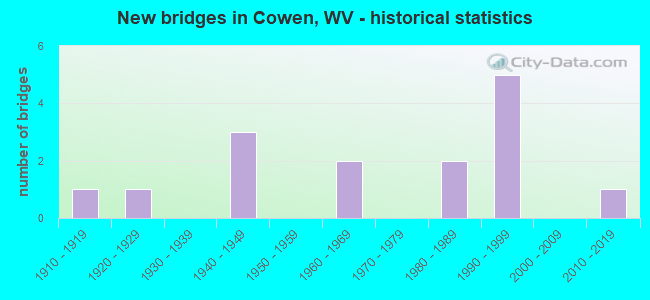
- New bridges - historical statistics
- 11910-1919
- 11920-1929
- 31940-1949
- 21960-1969
- 21980-1989
- 51990-1999
- 12010-2019

- Reconstructed bridges - Historical Statistics
- 11980-1989
- 11990-1999
- 02000-2009
- 12010-2019


- Bridge Condition - Deck
- 25.0%Good
- 41.7%Satisfactory
- 25.0%Fair
- 8.3%Poor

- Bridge Condition - Superstructure
- 35.7%Good
- 28.6%Satisfactory
- 35.7%Fair

- Bridge Condition - Substructure
- 21.4%Good
- 35.7%Satisfactory
- 35.7%Fair
- 7.1%Poor

- Bridge Condition - Channel
- 61.5%Good
- 23.1%Satisfactory
- 15.4%Fair
Find on map >> Show street view
Structure Number: 51A015, Location: 0.10 MI N OF CO 38 SLS (Lat: 38.455789, Lng: -80.525039), Route carried "on" structure: County highway 900, Year Built: 1987, Status: Open, Structure Length: 1.49m (4.89ft), Average Daily Traffic: 650 (year 2015), Truck Traffic: 9%, Average Future Daily Traffic: 689 (year 2035), Design Load: HS 25 or greater, Features Intersected: LAUREL CREEK, Facility Carried by Structure: COUNTY ROUTE 9
Minimum Vertical Clearance: 30+ m (98+ ft), Kilometerpoint: 7.162, Lanes on structure: 2, Owner: State Highway Agency, Approaching Roadway Width: 7.3m (24.0ft), Skew: 4 degrees, Material/Design: Steel, Design/Construction: Stringer/Multi-beam, Number Of Spans In Main Unit: 1, Length of Maximum Span: 13.4m (44.0ft), Curb-To-Curb Width: 7.9m (25.9ft), Out-to-Out Width: 8.8m (28.9ft)
Condition: Deck: Satisfactory, Superstructure: Good, Substructure: Satisfactory, Channel: Good, Operating Rating: 71.7 metric tons, Method Used To Determine Operating Rating: Load and Resistance Factor (LRFR), Inventory Rating: 55.3 metric tons, Method Used To Determine Inventory Rating: Load and Resistance Factor (LRFR), Structural Evaluation: Equal to present minimum criteria, Deck Geometry: Somewhat better than minimum adequacy, Waterway Adequacy: Superior to present desirable criteria, Approach Roadway Alignment: Equal to present desirable criteria, Designated Inspection Frequency: Every 24 months, Inspection Date: April 2020, Deck Structure Type: Concrete Cast-file-Place, Wearing Surface/Protective System: Wearing Surface: Bituminous, Deck Protection: Epoxy Coated Reinforcing
Find on map >> Show street view
Structure Number: 51A029, Location: 0.03 MI E OF WV 20 (Lat: 38.397489, Lng: -80.564131), Route carried "on" structure: County highway 1507, Year Built: 1968, Year Reconstructed: 1989, Status: Open, Structure Length: 1.47m (4.82ft), Average Daily Traffic: 40 (year 2018), Truck Traffic: 7%, Average Future Daily Traffic: 40 (year 2038), Features Intersected: BIG DITCH RUN, Facility Carried by Structure: COUNTY ROUTE 15/7
Minimum Vertical Clearance: 30+ m (98+ ft), Kilometerpoint: 0.048, Lanes on structure: 1, Owner: State Highway Agency, Approaching Roadway Width: 5.5m (18.0ft), Skew: 3 degrees, Material/Design: Steel continuous, Design/Construction: Stringer/Multi-beam, Number Of Spans In Main Unit: 2, Length of Maximum Span: 7.1m (23.3ft), Curb or Sidewalk Widths: Left: 0.2m (0.7ft), Right: 0.2m (0.7ft), Curb-To-Curb Width: 3.7m (12.1ft), Out-to-Out Width: 3.7m (12.1ft)
Condition: Deck: Satisfactory, Superstructure: Fair, Substructure: Satisfactory, Channel: Fair, Operating Rating: 62.6 metric tons, Method Used To Determine Operating Rating: Load Factor (LF), Inventory Rating: 37.2 metric tons, Method Used To Determine Inventory Rating: Load Factor (LF), Structural Evaluation: Somewhat better than minimum adequacy, Deck Geometry: Meets minimum limits, Waterway Adequacy: Better than present minimum criteria, Approach Roadway Alignment: Equal to present minimum criteria, Length Of Structure Improvement: 1.46m (4.79ft), Designated Inspection Frequency: Every 24 months, Inspection Date: October 2020, Bridge Improvement Cost: $25,000, Roadway Improvement Cost: $5,000, Total Project Cost: $40,000 ( Estimate for 2020), Deck Structure Type: Wood or Timber, Wearing Surface/Protective System: Wearing Surface: Bituminous
Find on map >> Show street view
Structure Number: 51A034, Location: 0.04 MI S OF CO 15/9 (Lat: 38.411431, Lng: -80.540231), Route carried "on" structure: State highway 2000, Year Built: 1991, Status: Open, Structure Length: 6.10m (20.01ft), Average Daily Traffic: 4,700 (year 2018), Truck Traffic: 12%, Average Future Daily Traffic: 4,935 (year 2038), Design Load: HS 25 or greater, Features Intersected: OLD CSX RAILROAD GRADE, Facility Carried by Structure: WV 20
Minimum Vertical Clearance: 30+ m (98+ ft), Kilometerpoint: 11.571, Lanes on structure: 2, Owner: State Highway Agency, Approaching Roadway Width: 9.1m (29.9ft), Skew: 6 degrees, Material/Design: Steel continuous, Design/Construction: Stringer/Multi-beam, Number Of Spans In Main Unit: 3, Length of Maximum Span: 19.5m (64.0ft), Curb or Sidewalk Widths: Left: 0.9m (3.0ft), Right: 0.9m (3.0ft), Curb-To-Curb Width: 7.9m (25.9ft), Out-to-Out Width: 9.1m (29.9ft)
Condition: Deck: Satisfactory, Superstructure: Good, Substructure: Fair, Operating Rating: 40.8 metric tons, Method Used To Determine Operating Rating: Load Factor (LF), Inventory Rating: 31.7 metric tons, Method Used To Determine Inventory Rating: Load Factor (LF), Structural Evaluation: Somewhat better than minimum adequacy, Deck Geometry: High priority of corrective action, Approach Roadway Alignment: Equal to present minimum criteria, Length Of Structure Improvement: 6.10m (20.01ft), Designated Inspection Frequency: Every 24 months, Inspection Date: September 2021, Bridge Improvement Cost: $880,000, Roadway Improvement Cost: $830,000, Total Project Cost: $2,000,000 ( Estimate for 2021), Deck Structure Type: Concrete Cast-file-Place, Wearing Surface/Protective System: Deck Protection: Epoxy Coated Reinforcing
Find on map >> Show street view
Structure Number: 51A056, Location: 2.38 MI W OF CO 44/8 (Lat: 38.443619, Lng: -80.577561), Route carried "on" structure: State highway 8200, Year Built: 1940, Status: Posted for load, Structure Length: 1.97m (6.46ft), Average Daily Traffic: 850 (year 2018), Truck Traffic: 13%, Average Future Daily Traffic: 900 (year 2038), Features Intersected: BIRCH RIVER, Facility Carried by Structure: WV 82
Minimum Vertical Clearance: 30+ m (98+ ft), Kilometerpoint: 13.856, Lanes on structure: 2, Owner: State Highway Agency, Approaching Roadway Width: 8.2m (26.9ft), Skew: 4 degrees, Material/Design: Steel, Design/Construction: Stringer/Multi-beam, Number Of Spans In Main Unit: 2, Length of Maximum Span: 9.0m (29.5ft), Curb or Sidewalk Widths: Left: 0.1m (0.3ft), Right: 0.1m (0.3ft), Curb-To-Curb Width: 6.9m (22.6ft), Out-to-Out Width: 7.5m (24.6ft)
Condition: Deck: Poor, Superstructure: Fair, Substructure: Poor, Channel: Satisfactory, Operating Rating: 50.8 metric tons, Method Used To Determine Operating Rating: Load Factor (LF), Inventory Rating: 29.9 metric tons, Method Used To Determine Inventory Rating: Load Factor (LF), Structural Evaluation: Meets minimum limits, Deck Geometry: Meets minimum limits, Waterway Adequacy: Superior to present desirable criteria, Approach Roadway Alignment: Equal to present desirable criteria, Bridge Posting: Required (Relationship of Operating Rating to Maximum Legal Load: 10.0 - 19.9% below), Length Of Structure Improvement: 2.74m (8.99ft), Designated Inspection Frequency: Every 24 months, Inspection Date: June 2021, Bridge Improvement Cost: $340,000, Roadway Improvement Cost: $333,000, Total Project Cost: $856,000 ( Estimate for 2021), Deck Structure Type: Concrete Cast-file-Place
Find on map >> Show street view
Structure Number: 51A057, Location: 3.39 MI E CO 32 (Lat: 38.454039, Lng: -80.577700), Route carried "on" structure: State highway 8200, Year Built: 1940, Status: Posted for load, Structure Length: 1.10m (3.61ft), Average Daily Traffic: 700 (year 2015), Truck Traffic: 19%, Average Future Daily Traffic: 775 (year 2035), Features Intersected: BIRCH RIVER, Facility Carried by Structure: WV 82
Minimum Vertical Clearance: 30+ m (98+ ft), Kilometerpoint: 12.601, Lanes on structure: 2, Owner: State Highway Agency, Approaching Roadway Width: 6.1m (20.0ft), Skew: 2 degrees, Material/Design: Concrete, Design/Construction: Slab, Number Of Spans In Main Unit: 1, Length of Maximum Span: 8.4m (27.6ft), Curb or Sidewalk Widths: Left: 0.2m (0.7ft), Right: 0.2m (0.7ft), Curb-To-Curb Width: 7.2m (23.6ft), Out-to-Out Width: 7.7m (25.3ft)
Condition: Deck: Satisfactory, Superstructure: Satisfactory, Substructure: Fair, Channel: Good, Operating Rating: 47.2 metric tons, Method Used To Determine Operating Rating: Field evaluation and documented engineering judgment, Inventory Rating: 21.8 metric tons, Method Used To Determine Inventory Rating: Field evaluation and documented engineering judgment, Structural Evaluation: Somewhat better than minimum adequacy, Deck Geometry: Meets minimum limits, Waterway Adequacy: Equal to present desirable criteria, Approach Roadway Alignment: Equal to present desirable criteria, Length Of Structure Improvement: 1.22m (4.00ft), Designated Inspection Frequency: Every 24 months, Inspection Date: Febuary 2020, Bridge Improvement Cost: $88,000, Roadway Improvement Cost: $87,000, Total Project Cost: $261,000 ( Estimate for 2020), Deck Structure Type: Concrete Cast-file-Place, Wearing Surface/Protective System: Wearing Surface: Bituminous
Find on map >> Show street view
Structure Number: 51A062, Location: 0.07 MI S CO 9 (Lat: 38.440500, Lng: -80.541011), Route carried "on" structure: County highway 3400, Year Built: 1940, Status: Open, Structure Length: 0.76m (2.49ft), Average Daily Traffic: 20 (year 2015), Average Future Daily Traffic: 25 (year 2035), Features Intersected: LAUREL CREEK, Facility Carried by Structure: COUNTY ROUTE 34
Minimum Vertical Clearance: 30+ m (98+ ft), Kilometerpoint: 4.522, Lanes on structure: 2, Owner: State Highway Agency, Approaching Roadway Width: 6.1m (20.0ft), Skew: 2 degrees, Material/Design: Concrete, Design/Construction: Slab, Number Of Spans In Main Unit: 1, Length of Maximum Span: 6.6m (21.7ft), Curb or Sidewalk Widths: Left: 0.5m (1.6ft), Right: 0.5m (1.6ft), Curb-To-Curb Width: 4.9m (16.1ft), Out-to-Out Width: 5.8m (19.0ft)
Condition: Superstructure: Fair, Substructure: Fair, Channel: Satisfactory, Operating Rating: 47.2 metric tons, Method Used To Determine Operating Rating: Field evaluation and documented engineering judgment, Inventory Rating: 21.8 metric tons, Method Used To Determine Inventory Rating: Field evaluation and documented engineering judgment, Structural Evaluation: Somewhat better than minimum adequacy, Deck Geometry: High priority of corrective action, Waterway Adequacy: Equal to present minimum criteria, Approach Roadway Alignment: Equal to present minimum criteria, Length Of Structure Improvement: 1.16m (3.81ft), Designated Inspection Frequency: Every 24 months, Inspection Date: Febuary 2020, Bridge Improvement Cost: $114,000, Roadway Improvement Cost: $113,000, Total Project Cost: $317,000 ( Estimate for 2020), Deck Structure Type: Concrete Cast-file-Place, Wearing Surface/Protective System: Wearing Surface: Bituminous
Find on map >> Show street view
Structure Number: 51A065, Location: 0.01 MI S CO 9 (Lat: 38.458900, Lng: -80.523069), Route carried "on" structure: County highway 3600, Year Built: 1961, Year Reconstructed: 1999, Status: Posted for load, Structure Length: 1.00m (3.28ft), Average Daily Traffic: 20 (year 2018), Average Future Daily Traffic: 23 (year 2038), Features Intersected: LAUREL CREEK, Facility Carried by Structure: CO 36
Minimum Vertical Clearance: 30+ m (98+ ft), Kilometerpoint: 7.290, Lanes on structure: 1, Owner: State Highway Agency, Approaching Roadway Width: 4.3m (14.1ft), Material/Design: Steel, Design/Construction: Stringer/Multi-beam, Number Of Spans In Main Unit: 1, Length of Maximum Span: 9.4m (30.8ft), Curb or Sidewalk Widths: Left: 0.2m (0.7ft), Right: 0.2m (0.7ft), Curb-To-Curb Width: 4.3m (14.1ft), Out-to-Out Width: 4.3m (14.1ft)
Condition: Deck: Fair, Superstructure: Satisfactory, Substructure: Satisfactory, Channel: Satisfactory, Operating Rating: 42.6 metric tons, Method Used To Determine Operating Rating: Load Factor (LF), Inventory Rating: 25.4 metric tons, Method Used To Determine Inventory Rating: Load Factor (LF), Structural Evaluation: Equal to present minimum criteria, Deck Geometry: Equal to present minimum criteria, Waterway Adequacy: Equal to present desirable criteria, Approach Roadway Alignment: Equal to present desirable criteria, Bridge Posting: Required (Relationship of Operating Rating to Maximum Legal Load: 0.1 - 9.9% below), Length Of Structure Improvement: 1.22m (4.00ft), Designated Inspection Frequency: Every 24 months, Inspection Date: July 2021, Bridge Improvement Cost: $250,000, Roadway Improvement Cost: $50,000, Total Project Cost: $350,000 ( Estimate for 2021), Deck Structure Type: Wood or Timber
Find on map >> Show street view
Structure Number: 51A068, Location: 0.01 MI W OF CO 15/7 SLS (Lat: 38.404019, Lng: -80.528889), Route carried "on" structure: County highway 4600, Year Built: 1927, Status: Open, Structure Length: 0.67m (2.20ft), Average Daily Traffic: 600 (year 2018), Truck Traffic: 11%, Average Future Daily Traffic: 630 (year 2038), Features Intersected: PRICE GLADE RUN, Facility Carried by Structure: COUNTY ROUTE 46
Minimum Vertical Clearance: 30+ m (98+ ft), Kilometerpoint: 0.772, Lanes on structure: 2, Owner: State Highway Agency, Approaching Roadway Width: 8.5m (27.9ft), Material/Design: Concrete, Design/Construction: Slab, Number Of Spans In Main Unit: 1, Length of Maximum Span: 6.2m (20.3ft), Curb or Sidewalk Widths: Left: 0.1m (0.3ft), Right: 0.0m, Curb-To-Curb Width: 6.9m (22.6ft), Out-to-Out Width: 7.6m (24.9ft)
Condition: Deck: Fair, Superstructure: Fair, Substructure: Satisfactory, Channel: Good, Operating Rating: 47.2 metric tons, Method Used To Determine Operating Rating: Field evaluation and documented engineering judgment, Inventory Rating: 21.8 metric tons, Method Used To Determine Inventory Rating: Field evaluation and documented engineering judgment, Structural Evaluation: Somewhat better than minimum adequacy, Deck Geometry: Meets minimum limits, Waterway Adequacy: Equal to present minimum criteria, Approach Roadway Alignment: Equal to present minimum criteria, Length Of Structure Improvement: 0.91m (2.99ft), Designated Inspection Frequency: Every 24 months, Inspection Date: June 2021, Bridge Improvement Cost: $150,000, Roadway Improvement Cost: $30,000, Total Project Cost: $220,000 ( Estimate for 2021), Deck Structure Type: Concrete Cast-file-Place, Wearing Surface/Protective System: Wearing Surface: Bituminous
Find on map >> Show street view
Structure Number: 51A069, Location: 0.03 MI E OF CO RT 46/8 (Lat: 38.387269, Lng: -80.510769), Route carried "on" structure: County highway 4600, Year Built: 1915, Status: Open, Structure Length: 3.97m (13.02ft), Average Daily Traffic: 250 (year 2018), Truck Traffic: 11%, Average Future Daily Traffic: 263 (year 2038), Features Intersected: GAULEY RIVER, Facility Carried by Structure: COUNTY ROUTE 46
Minimum Vertical Clearance: 30+ m (98+ ft), Kilometerpoint: 3.508, Lanes on structure: 2, Owner: State Highway Agency, Approaching Roadway Width: 7.0m (23.0ft), Material/Design: Concrete, Design/Construction: Arch - Deck, Number Of Spans In Main Unit: 2, Length of Maximum Span: 17.5m (57.4ft), Curb-To-Curb Width: 7.8m (25.6ft), Out-to-Out Width: 7.9m (25.9ft)
Condition: Superstructure: Fair, Substructure: Fair, Channel: Fair, Operating Rating: 41.7 metric tons, Method Used To Determine Operating Rating: Field evaluation and documented engineering judgment, Inventory Rating: 17.2 metric tons, Method Used To Determine Inventory Rating: Field evaluation and documented engineering judgment, Structural Evaluation: Somewhat better than minimum adequacy, Deck Geometry: Somewhat better than minimum adequacy, Waterway Adequacy: Superior to present desirable criteria, Approach Roadway Alignment: Equal to present minimum criteria, Length Of Structure Improvement: 4.75m (15.58ft), Designated Inspection Frequency: Every 24 months, Inspection Date: June 2021, Bridge Improvement Cost: $482,000, Roadway Improvement Cost: $463,000, Total Project Cost: $1,231,000 ( Estimate for 2022)
Find on map >> Show street view
Structure Number: 51A072, Location: 0.09 MI E OF WV 20 (Lat: 38.408531, Lng: -80.555581), Route carried "on" structure: County highway 2027, Year Built: 1983, Status: Open, Structure Length: 1.15m (3.77ft), Average Daily Traffic: 20 (year 2018), Truck Traffic: 11%, Average Future Daily Traffic: 21 (year 2038), Design Load: H 20, Features Intersected: BIG DITCH RUN, Facility Carried by Structure: COUNTY ROUTE 20/27
Minimum Vertical Clearance: 30+ m (98+ ft), Kilometerpoint: 0.145, Lanes on structure: 1, Owner: State Highway Agency, Approaching Roadway Width: 5.2m (17.1ft), Material/Design: Steel, Design/Construction: Girder and Floorbeam System, Number Of Spans In Main Unit: 1, Length of Maximum Span: 10.7m (35.1ft), Curb or Sidewalk Widths: Left: 0.0m, Right: 0.9m (3.0ft), Curb-To-Curb Width: 4.5m (14.8ft), Out-to-Out Width: 5.8m (19.0ft)
Condition: Deck: Satisfactory, Superstructure: Satisfactory, Substructure: Satisfactory, Channel: Good, Operating Rating: 58.0 metric tons, Method Used To Determine Operating Rating: Load Factor (LF), Inventory Rating: 34.5 metric tons, Method Used To Determine Inventory Rating: Load Factor (LF), Structural Evaluation: Equal to present minimum criteria, Deck Geometry: Equal to present minimum criteria, Waterway Adequacy: Better than present minimum criteria, Approach Roadway Alignment: Equal to present desirable criteria, Designated Inspection Frequency: Every 24 months, Critical Feature Inspection Frequency: Every 24 months, Inspection Date: July 2021, Critical Feature Inspection Date: July 2021, Deck Structure Type: Wood or Timber, Wearing Surface/Protective System: Wearing Surface: Bituminous
Find on map >> Show street view
Structure Number: 51A086, Location: 0.23 MI S OF CO 38 (Lat: 38.455569, Lng: -80.528869), Route carried "on" structure: County highway 900, Year Built: 1997, Status: Open, Structure Length: 1.13m (3.71ft), Average Daily Traffic: 1,700 (year 2018), Truck Traffic: 10%, Average Future Daily Traffic: 1,785 (year 2038), Features Intersected: LAUREL CREEK, Facility Carried by Structure: COUNTY ROUTE 9
Minimum Vertical Clearance: 30+ m (98+ ft), Kilometerpoint: 6.630, Lanes on structure: 2, Owner: State Highway Agency, Approaching Roadway Width: 7.3m (24.0ft), Skew: 4 degrees, Material/Design: Prestressed concrete, Design/Construction: Box Beam or Girders - Multiple, Number Of Spans In Main Unit: 1, Length of Maximum Span: 9.4m (30.8ft), Curb-To-Curb Width: 7.7m (25.3ft), Out-to-Out Width: 8.3m (27.2ft)
Condition: Deck: Good, Superstructure: Good, Substructure: Good, Channel: Good, Operating Rating: 64.4 metric tons, Method Used To Determine Operating Rating: Load and Resistance Factor (LRFR), Inventory Rating: 49.9 metric tons, Method Used To Determine Inventory Rating: Load and Resistance Factor (LRFR), Structural Evaluation: Better than present minimum criteria, Deck Geometry: Meets minimum limits, Waterway Adequacy: Superior to present desirable criteria, Approach Roadway Alignment: Equal to present minimum criteria, Designated Inspection Frequency: Every 24 months, Inspection Date: August 2021, Deck Structure Type: Concrete Cast-file-Place, Wearing Surface/Protective System: Wearing Surface: Bituminous, Deck Protection: Epoxy Coated Reinforcing
Find on map >> Show street view
Structure Number: 51A1, Location: 0.34 MI N WV 20 (Lat: 38.412861, Lng: -80.554011), Route carried "on" structure: County highway 2025, Year Built: 1990, Year Reconstructed: 2010, Status: Open, Structure Length: 1.12m (3.67ft), Average Daily Traffic: 50 (year 2018), Average Future Daily Traffic: 53 (year 2038), Design Load: HS 25 or greater, Features Intersected: BIG DITCH CREEK, Facility Carried by Structure: COUNTY ROUTE 20/25
Minimum Vertical Clearance: 30+ m (98+ ft), Kilometerpoint: 0.547, Lanes on structure: 2, Owner: State Highway Agency, Approaching Roadway Width: 5.2m (17.1ft), Material/Design: Prestressed concrete, Design/Construction: Box Beam or Girders - Multiple, Number Of Spans In Main Unit: 1, Length of Maximum Span: 10.1m (33.1ft), Curb-To-Curb Width: 6.2m (20.3ft), Out-to-Out Width: 6.2m (20.3ft)
Condition: Deck: Good, Superstructure: Good, Substructure: Good, Channel: Good, Operating Rating: 71.7 metric tons, Method Used To Determine Operating Rating: Load Factor (LF), Inventory Rating: 42.6 metric tons, Method Used To Determine Inventory Rating: Load Factor (LF), Structural Evaluation: Better than present minimum criteria, Deck Geometry: Somewhat better than minimum adequacy, Waterway Adequacy: Superior to present desirable criteria, Approach Roadway Alignment: Equal to present desirable criteria, Designated Inspection Frequency: Every 48 months, Inspection Date: July 2021, Deck Structure Type: Other, Wearing Surface/Protective System: Wearing Surface: Bituminous
Find on map >> Show street view
Structure Number: 51A101, Location: 2.21 MI E CO 22 (Lat: 38.466131, Lng: -80.587689), Route carried "on" structure: State highway 82, Year Built: 2016, Status: Open, Structure Length: 1.90m (6.23ft), Average Daily Traffic: 697 (year 2015), Truck Traffic: 8%, Average Future Daily Traffic: 765 (year 2035), Design Load: Greater than HL93, Features Intersected: BIRCH RIVER
Minimum Vertical Clearance: 30+ m (98+ ft), Kilometerpoint: 10.702, Lanes on structure: 2, Owner: State Highway Agency, Approaching Roadway Width: 8.8m (28.9ft), Skew: 1 degrees, Material/Design: Prestressed concrete, Design/Construction: Box Beam or Girders - Single/Spread, Number Of Spans In Main Unit: 1, Length of Maximum Span: 0.0m, Curb-To-Curb Width: 8.6m (28.2ft), Out-to-Out Width: 9.3m (30.5ft)
Condition: Deck: Good, Superstructure: Good, Substructure: Good, Channel: Good, Operating Rating: 88.9 metric tons, Method Used To Determine Operating Rating: Load and Resistance Factor (LRFR), Inventory Rating: 53.5 metric tons, Method Used To Determine Inventory Rating: Load and Resistance Factor (LRFR), Structural Evaluation: Better than present minimum criteria, Deck Geometry: Somewhat better than minimum adequacy, Waterway Adequacy: Equal to present desirable criteria, Approach Roadway Alignment: Equal to present desirable criteria, Designated Inspection Frequency: Every 48 months, Inspection Date: June 2019, Deck Structure Type: Concrete Cast-file-Place, Wearing Surface/Protective System: Wearing Surface: Monolithic Concrete, Membrane: Epoxy, Deck Protection: Epoxy Coated Reinforcing
Find on map >> Show street view
Structure Number: 92100000032022, Location: NO DATA ENTERED (Lat: 38.383350, Lng: -80.539186), Route carried "on" structure: Federal lands road 911, Year Built: 1996, Status: Posted for load, Structure Length: 1.49m (4.89ft), Average Daily Traffic: 50 (year 0000), Average Future Daily Traffic: 75 (year 2042), Features Intersected: HOLCOMBE CREEK
Minimum Vertical Clearance: 30+ m (98+ ft), Kilometerpoint: 0.640, Lanes on structure: 1, Owner: U.S. Forest Service, Approaching Roadway Width: 4.3m (14.1ft), Material/Design: Steel, Design/Construction: Stringer/Multi-beam, Number Of Spans In Main Unit: 1, Length of Maximum Span: 14.6m (47.9ft), Curb-To-Curb Width: 3.7m (12.1ft), Out-to-Out Width: 4.0m (13.1ft)
Condition: Deck: Fair, Superstructure: Satisfactory, Substructure: Fair, Channel: Good, Operating Rating: 16.5 metric tons, Method Used To Determine Operating Rating: Load and Resistance Factor Rating (LRFR) rating reported by rating factor(RF) method using HL-93 loadings, Inventory Rating: 12.6 metric tons, Method Used To Determine Inventory Rating: Load and Resistance Factor Rating (LRFR) rating reported by rating factor(RF) method using HL-93 loadings, Structural Evaluation: Meets minimum limits, Deck Geometry: Meets minimum limits, Waterway Adequacy: Equal to present minimum criteria, Approach Roadway Alignment: High priority of corrective action, Bridge Posting: Required (Relationship of Operating Rating to Maximum Legal Load: > 39.9% below), Designated Inspection Frequency: Every 24 months, Inspection Date: November 2020, Deck Structure Type: Wood or Timber, Wearing Surface/Protective System: Wearing Surface: Wood or Timber
Find on map >> Show street view
Structure Number: 51A088, Location: 0.15 MI S OF CO 20/28 (Lat: 38.407239, Lng: -80.531131), Route carried "under" structure: State highway 2000, Year Built: 1998, Structure Length: 0. m, Average Daily Traffic: 4,666 (year 2015), Truck Traffic: 10%, Features Intersected: STEAM PIPE, Facility Carried by Structure: GLADEVIEW STEAM PI
Minimum Vertical Clearance: 6.05m (19.85ft), Kilometerpoint: 12.505, Lanes under structure: 2, Length of Maximum Span: 19.5m (64.0ft)