Bridge Statistics for Crab Orchard, Tennessee (TN)
Condition, Traffic, Stress, Structural Evaluation, Project Costs
- National Bridge Inventory (NBI) Statistics
- 38Number of bridges
- 427ft / 130mTotal length
- $15,821,000Total costs
- 432,338Total average daily traffic
- 206,108Total average daily truck traffic
- National Bridge Inventory (NBI) Registered Bridges for Crab Orchard
- No street view available for this location
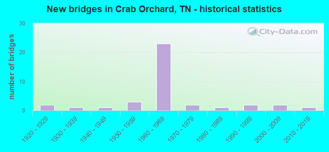
- New bridges - historical statistics
- 21920-1929
- 11930-1939
- 11940-1949
- 31950-1959
- 231960-1969
- 21970-1979
- 11980-1989
- 21990-1999
- 22000-2009
- 12010-2019

- Reconstructed bridges - Historical Statistics
- 11940-1949
- 11950-1959
- 01960-1969
- 01970-1979
- 31980-1989
- 51990-1999


- Bridge Condition - Deck
- 23.8%Good
- 23.8%Satisfactory
- 47.6%Fair
- 4.8%Poor

- Bridge Condition - Superstructure
- 33.3%Good
- 38.1%Satisfactory
- 19.0%Fair
- 9.5%Poor

- Bridge Condition - Substructure
- 33.3%Good
- 23.8%Satisfactory
- 38.1%Fair
- 4.8%Poor

- Bridge Condition - Channel
- 56.3%Good
- 25.0%Satisfactory
- 18.8%Fair

- Bridge Condition - Culverts
- 60.0%Good
- 40.0%Fair
Find on map >> Show street view
Structure Number: 18008840001, Location: CITY OF CRAB ORCHARD (Lat: 35.923567, Lng: -84.871233), Route carried "on" structure: City street 884, Year Built: 1976, Status: Open, Structure Length: 0.67m (2.20ft), Average Daily Traffic: 211 (year 2020), Truck Traffic: 3%, Average Future Daily Traffic: 912 (year 2040), Design Load: HS 20, Features Intersected: BAKERS BRANCH
Minimum Vertical Clearance: 30+ m (98+ ft), Kilometerpoint: 2.430, Lanes on structure: 2, Owner: City or Municipal Highway Agency, Approaching Roadway Width: 12.2m (40.0ft), Material/Design: Concrete continuous, Design/Construction: Culvert, Number Of Spans In Main Unit: 2, Length of Maximum Span: 3.0m (9.8ft)
Condition: Channel: Good, Culverts: Good, Operating Rating: 89.1 metric tons, Method Used To Determine Operating Rating: Load Factor (LF), Inventory Rating: 32.4 metric tons, Method Used To Determine Inventory Rating: Load Factor (LF), Structural Evaluation: Better than present minimum criteria, Waterway Adequacy: Equal to present desirable criteria, Approach Roadway Alignment: Equal to present desirable criteria, Designated Inspection Frequency: Every 24 months, Inspection Date: May 2020
Find on map >> Show street view
Structure Number: 180A2130001, Location: SOUTH OF US70 (Lat: 35.870667, Lng: -84.804333), Route carried "on" structure: County highway 213, Year Built: 1993, Status: Open, Structure Length: 1.92m (6.30ft), Average Daily Traffic: 60 (year 2022), Truck Traffic: 2%, Average Future Daily Traffic: 96 (year 2040), Design Load: HS 20, Features Intersected: FALL BRANCH
Minimum Vertical Clearance: 30+ m (98+ ft), Kilometerpoint: 1.254, Lanes on structure: 2, Owner: County Highway Agency, Approaching Roadway Width: 4.9m (16.1ft), Material/Design: Concrete continuous, Design/Construction: Culvert, Number Of Spans In Main Unit: 3, Length of Maximum Span: 6.0m (19.7ft), Curb-To-Curb Width: 6.8m (22.3ft), Out-to-Out Width: 8.4m (27.6ft)
Condition: Channel: Good, Culverts: Good, Operating Rating: 89.1 metric tons, Method Used To Determine Operating Rating: Load Factor (LF), Inventory Rating: 32.4 metric tons, Method Used To Determine Inventory Rating: Load Factor (LF), Structural Evaluation: Better than present minimum criteria, Deck Geometry: Somewhat better than minimum adequacy, Waterway Adequacy: Better than present minimum criteria, Approach Roadway Alignment: Equal to present minimum criteria, Designated Inspection Frequency: Every 24 months, Inspection Date: May 2020, Deck Structure Type: Concrete Cast-file-Place, Wearing Surface/Protective System: Wearing Surface: Monolithic Concrete, Deck Protection: Epoxy Coated Reinforcing
Find on map >> Show street view
Structure Number: 180A2340001, Location: CITY OF CRAB ORCHARD (Lat: 35.927006, Lng: -84.876022), Route carried "on" structure: City street 234, Year Built: 1976, Status: Open, Structure Length: 3.17m (10.40ft), Average Daily Traffic: 559 (year 2022), Truck Traffic: 2%, Average Future Daily Traffic: 894 (year 2040), Design Load: H 15, Features Intersected: DADDY'S CREEK
Minimum Vertical Clearance: 30+ m (98+ ft), Kilometerpoint: 2.121, Lanes on structure: 2, Owner: City or Municipal Highway Agency, Approaching Roadway Width: 7.9m (25.9ft), Material/Design: Prestressed concrete, Design/Construction: Stringer/Multi-beam, Number Of Spans In Main Unit: 1, Length of Maximum Span: 30.5m (100.1ft), Curb-To-Curb Width: 8.0m (26.2ft), Out-to-Out Width: 8.4m (27.6ft)
Condition: Deck: Fair, Superstructure: Good, Substructure: Good, Channel: Good, Operating Rating: 25.2 metric tons, Method Used To Determine Operating Rating: Load Factor (LF), Inventory Rating: 22.5 metric tons, Method Used To Determine Inventory Rating: Load Factor (LF), Structural Evaluation: Equal to present minimum criteria, Deck Geometry: Somewhat better than minimum adequacy, Waterway Adequacy: Equal to present desirable criteria, Approach Roadway Alignment: Equal to present minimum criteria, Designated Inspection Frequency: Every 24 months, Inspection Date: May 2020, Deck Structure Type: Concrete Cast-file-Place, Wearing Surface/Protective System: Wearing Surface: Bituminous
Find on map >> Show street view
Structure Number: 180A3130001, Location: SOUTH OF I40 (Lat: 35.932150, Lng: -84.951300), Route carried "on" structure: County highway 313, Year Built: 1985, Status: Open, Structure Length: 1.49m (4.89ft), Average Daily Traffic: 470 (year 2022), Truck Traffic: 2%, Average Future Daily Traffic: 752 (year 2040), Design Load: HS 20, Features Intersected: BYRD CREEK
Minimum Vertical Clearance: 30+ m (98+ ft), Kilometerpoint: 2.242, Lanes on structure: 2, Owner: County Highway Agency, Approaching Roadway Width: 7.3m (24.0ft), Material/Design: Concrete, Design/Construction: Culvert, Number Of Spans In Main Unit: 1, Length of Maximum Span: 4.6m (15.1ft), Curb-To-Curb Width: 9.4m (30.8ft), Out-to-Out Width: 10.5m (34.4ft)
Condition: Channel: Fair, Culverts: Good, Operating Rating: 89.1 metric tons, Method Used To Determine Operating Rating: Load Factor (LF), Inventory Rating: 32.4 metric tons, Method Used To Determine Inventory Rating: Load Factor (LF), Structural Evaluation: Better than present minimum criteria, Deck Geometry: Equal to present minimum criteria, Waterway Adequacy: Better than present minimum criteria, Approach Roadway Alignment: Equal to present desirable criteria, Designated Inspection Frequency: Every 24 months, Inspection Date: May 2020
Find on map >> Show street view
Structure Number: 18F00130001, Location: SOUTH OF I40 (Lat: 35.923417, Lng: -84.935667), Route carried "on" structure: County highway 1168, Year Built: 1934, Status: Open, Structure Length: 1.25m (4.10ft), Average Daily Traffic: 460 (year 2020), Truck Traffic: 3%, Average Future Daily Traffic: 912 (year 2040), Design Load: H 15, Features Intersected: BYRD CREEK
Minimum Vertical Clearance: 30+ m (98+ ft), Kilometerpoint: 6.083, Lanes on structure: 2, Owner: County Highway Agency, Approaching Roadway Width: 7.3m (24.0ft), Material/Design: Masonry, Design/Construction: Arch - Deck, Number Of Spans In Main Unit: 1, Length of Maximum Span: 11.6m (38.1ft), Curb-To-Curb Width: 7.7m (25.3ft), Out-to-Out Width: 8.6m (28.2ft)
Condition: Deck: Fair, Superstructure: Fair, Substructure: Fair, Channel: Satisfactory, Operating Rating: 36.0 metric tons, Method Used To Determine Operating Rating: Field evaluation and documented engineering judgment, Inventory Rating: 24.3 metric tons, Method Used To Determine Inventory Rating: Field evaluation and documented engineering judgment, Structural Evaluation: Somewhat better than minimum adequacy, Deck Geometry: Meets minimum limits, Waterway Adequacy: Better than present minimum criteria, Approach Roadway Alignment: High priority of corrective action, Length Of Structure Improvement: 1.25m (4.10ft), Designated Inspection Frequency: Every 24 months, Inspection Date: May 2020, Bridge Improvement Cost: $215,000, Roadway Improvement Cost: $22,000, Total Project Cost: $323,000 ( Estimate for 2020)
Find on map >> Show street view
Structure Number: 18I00400001, Location: PUTNAM-CUMBERLAND CO.LN. (Lat: 36.093167, Lng: -85.235167), Route carried "on" structure: Interstate 40, Year Built: 1963, Year Reconstructed: 1980, Status: Open, Structure Length: 9.27m (30.41ft), Average Daily Traffic: 29,996 (year 2020), Truck Traffic: 34%, Average Future Daily Traffic: 47,994 (year 2041), Design Load: HS 20+Mod, Features Intersected: SR 24
Minimum Vertical Clearance: 30+ m (98+ ft), Kilometerpoint: 0.386, Lanes on structure: 2, Lanes under structure: 2, Base Highway Network: Yes, Owner: State Highway Agency, Approaching Roadway Width: 11.0m (36.1ft), Skew: 14 degrees, Material/Design: Prestressed concrete, Design/Construction: Stringer/Multi-beam, Number Of Spans In Main Unit: 5, Length of Maximum Span: 22.6m (74.1ft), Curb-To-Curb Width: 12.5m (41.0ft), Out-to-Out Width: 13.4m (44.0ft)
Condition: Deck: Poor, Superstructure: Fair, Substructure: Fair, Operating Rating: 26.6 metric tons, Method Used To Determine Operating Rating: Load and Resistance Factor Rating (LRFR) rating reported by rating factor(RF) method using HL-93 loadings, Inventory Rating: 12.3 metric tons, Method Used To Determine Inventory Rating: Load and Resistance Factor Rating (LRFR) rating reported by rating factor(RF) method using HL-93 loadings, Structural Evaluation: High priority of corrective action, Deck Geometry: Better than present minimum criteria, Underclear: Equal to present minimum criteria, Approach Roadway Alignment: Equal to present desirable criteria, Length Of Structure Improvement: 9.27m (30.41ft), Designated Inspection Frequency: Every 24 months, Inspection Date: October 2021, Bridge Improvement Cost: $2,040,000, Roadway Improvement Cost: $205,000, Total Project Cost: $3,061,000 ( Estimate for 2021), Deck Structure Type: Concrete Cast-file-Place, Wearing Surface/Protective System: Wearing Surface: Bituminous, Deck Protection: Epoxy Coated Reinforcing
Find on map >> Show street view
Structure Number: 18I00400031, Location: 1.8 MI FROM SR1 (Lat: 35.925717, Lng: -84.914917), Route carried "on" structure: Interstate 40, Year Built: 1966, Year Reconstructed: 1999, Status: Open, Structure Length: 10.09m (33.10ft), Average Daily Traffic: 28,806 (year 2020), Truck Traffic: 47%, Average Future Daily Traffic: 46,090 (year 2042), Design Load: HS 20, Features Intersected: DADDYS CREEK & NFA A244
Minimum Vertical Clearance: 30+ m (98+ ft), Kilometerpoint: 36.017, Lanes on structure: 2, Lanes under structure: 2, Base Highway Network: Yes, Owner: State Highway Agency, Approaching Roadway Width: 11.6m (38.1ft), Skew: 10 degrees, Material/Design: Steel continuous, Design/Construction: Stringer/Multi-beam, Number Of Spans In Main Unit: 3, Length of Maximum Span: 38.7m (127.0ft), Curb-To-Curb Width: 12.1m (39.7ft), Out-to-Out Width: 12.7m (41.7ft)
Condition: Deck: Fair, Superstructure: Satisfactory, Substructure: Satisfactory, Channel: Good, Operating Rating: 26.9 metric tons, Method Used To Determine Operating Rating: Load and Resistance Factor Rating (LRFR) rating reported by rating factor(RF) method using HL-93 loadings, Inventory Rating: 20.7 metric tons, Method Used To Determine Inventory Rating: Load and Resistance Factor Rating (LRFR) rating reported by rating factor(RF) method using HL-93 loadings, Structural Evaluation: Somewhat better than minimum adequacy, Deck Geometry: Equal to present minimum criteria, Underclear: Somewhat better than minimum adequacy, Waterway Adequacy: Better than present minimum criteria, Approach Roadway Alignment: Equal to present desirable criteria, Length Of Structure Improvement: 10.09m (33.10ft), Designated Inspection Frequency: Every 24 months, Inspection Date: October 2021, Bridge Improvement Cost: $2,524,000, Roadway Improvement Cost: $253,000, Total Project Cost: $3,787,000 ( Estimate for 2022), Deck Structure Type: Concrete Cast-file-Place, Wearing Surface/Protective System: Wearing Surface: Monolithic Concrete, Deck Protection: Epoxy Coated Reinforcing
Find on map >> Show street view
Structure Number: 18I00400032, Location: 1.8 MI FROM SR1 (Lat: 35.925383, Lng: -84.913800), Route carried "on" structure: Interstate 40, Year Built: 1966, Year Reconstructed: 1999, Status: Open, Structure Length: 10.09m (33.10ft), Average Daily Traffic: 28,806 (year 2020), Truck Traffic: 47%, Average Future Daily Traffic: 46,090 (year 2042), Design Load: HS 20+Mod, Features Intersected: DADDYS CREEK & NFA A244
Minimum Vertical Clearance: 30+ m (98+ ft), Kilometerpoint: 36.017, Lanes on structure: 2, Lanes under structure: 2, Base Highway Network: Yes, Owner: State Highway Agency, Approaching Roadway Width: 11.6m (38.1ft), Skew: 10 degrees, Material/Design: Steel continuous, Design/Construction: Stringer/Multi-beam, Number Of Spans In Main Unit: 3, Length of Maximum Span: 33.2m (108.9ft), Curb-To-Curb Width: 12.1m (39.7ft), Out-to-Out Width: 12.7m (41.7ft)
Condition: Deck: Fair, Superstructure: Good, Substructure: Fair, Channel: Good, Operating Rating: 45.0 metric tons, Method Used To Determine Operating Rating: Load Factor (LF), Inventory Rating: 27.0 metric tons, Method Used To Determine Inventory Rating: Load Factor (LF), Structural Evaluation: Somewhat better than minimum adequacy, Deck Geometry: Equal to present minimum criteria, Underclear: Better than present minimum criteria, Waterway Adequacy: Better than present minimum criteria, Approach Roadway Alignment: Equal to present desirable criteria, Length Of Structure Improvement: 10.09m (33.10ft), Designated Inspection Frequency: Every 24 months, Inspection Date: October 2021, Bridge Improvement Cost: $2,412,000, Roadway Improvement Cost: $242,000, Total Project Cost: $3,619,000 ( Estimate for 2022), Deck Structure Type: Concrete Cast-file-Place, Wearing Surface/Protective System: Wearing Surface: Monolithic Concrete, Deck Protection: Epoxy Coated Reinforcing
Find on map >> Show street view
Structure Number: 18I00400033, Location: .1MI FROM SR1 (Lat: 35.911667, Lng: -84.893333), Route carried "on" structure: Interstate 40, Year Built: 1967, Status: Open, Structure Length: 6.04m (19.82ft), Average Daily Traffic: 28,806 (year 2020), Truck Traffic: 47%, Average Future Daily Traffic: 46,090 (year 2041), Design Load: HS 20+Mod, Features Intersected: NFA A244
Minimum Vertical Clearance: 30+ m (98+ ft), Kilometerpoint: 38.496, Lanes on structure: 2, Lanes under structure: 2, Base Highway Network: Yes, Owner: State Highway Agency, Approaching Roadway Width: 11.6m (38.1ft), Skew: 13 degrees, Material/Design: Prestressed concrete continuous, Design/Construction: Stringer/Multi-beam, Number Of Spans In Main Unit: 4, Length of Maximum Span: 15.2m (49.9ft), Curb-To-Curb Width: 11.6m (38.1ft), Out-to-Out Width: 12.8m (42.0ft)
Condition: Deck: Fair, Superstructure: Satisfactory, Substructure: Fair, Operating Rating: 45.9 metric tons, Method Used To Determine Operating Rating: Load Factor (LF), Inventory Rating: 32.4 metric tons, Method Used To Determine Inventory Rating: Load Factor (LF), Structural Evaluation: Somewhat better than minimum adequacy, Deck Geometry: Equal to present minimum criteria, Underclear: Somewhat better than minimum adequacy, Approach Roadway Alignment: Equal to present desirable criteria, Designated Inspection Frequency: Every 24 months, Inspection Date: October 2021, Deck Structure Type: Concrete Cast-file-Place, Wearing Surface/Protective System: Wearing Surface: Bituminous
Find on map >> Show street view
Structure Number: 18I00400034, Location: .1 MI FROM SR1 (Lat: 35.911667, Lng: -84.893333), Route carried "on" structure: Interstate 40, Year Built: 1966, Status: Open, Structure Length: 6.04m (19.82ft), Average Daily Traffic: 28,806 (year 2020), Truck Traffic: 47%, Average Future Daily Traffic: 46,090 (year 2042), Design Load: HS 20+Mod, Features Intersected: NFA A244
Minimum Vertical Clearance: 30+ m (98+ ft), Kilometerpoint: 38.496, Lanes on structure: 2, Lanes under structure: 2, Base Highway Network: Yes, Owner: State Highway Agency, Approaching Roadway Width: 11.6m (38.1ft), Skew: 13 degrees, Material/Design: Prestressed concrete continuous, Design/Construction: Stringer/Multi-beam, Number Of Spans In Main Unit: 4, Length of Maximum Span: 15.2m (49.9ft), Curb-To-Curb Width: 11.6m (38.1ft), Out-to-Out Width: 12.8m (42.0ft)
Condition: Deck: Fair, Superstructure: Fair, Substructure: Poor, Operating Rating: 45.0 metric tons, Method Used To Determine Operating Rating: Load and Resistance Factor Rating (LRFR) rating reported by rating factor(RF) method using HL-93 loadings, Inventory Rating: 27.5 metric tons, Method Used To Determine Inventory Rating: Load and Resistance Factor Rating (LRFR) rating reported by rating factor(RF) method using HL-93 loadings, Structural Evaluation: Meets minimum limits, Deck Geometry: Equal to present minimum criteria, Underclear: Meets minimum limits, Approach Roadway Alignment: Equal to present desirable criteria, Designated Inspection Frequency: Every 24 months, Inspection Date: October 2021, Deck Structure Type: Concrete Cast-file-Place, Wearing Surface/Protective System: Wearing Surface: Bituminous
Find on map >> Show street view
Structure Number: 18I00400035, Location: 1 MI FROM COX VALLEY RD (Lat: 35.910000, Lng: -84.890000), Route carried "on" structure: Interstate 40, Year Built: 1966, Status: Open, Structure Length: 4.94m (16.21ft), Average Daily Traffic: 28,806 (year 2020), Truck Traffic: 47%, Average Future Daily Traffic: 46,090 (year 2042), Design Load: HS 20+Mod, Features Intersected: SR 1
Minimum Vertical Clearance: 30+ m (98+ ft), Kilometerpoint: 38.866, Lanes on structure: 2, Lanes under structure: 2, Base Highway Network: Yes, Owner: State Highway Agency, Approaching Roadway Width: 11.6m (38.1ft), Skew: 13 degrees, Material/Design: Prestressed concrete continuous, Design/Construction: Stringer/Multi-beam, Number Of Spans In Main Unit: 3, Length of Maximum Span: 18.6m (61.0ft), Curb-To-Curb Width: 11.6m (38.1ft), Out-to-Out Width: 12.8m (42.0ft)
Condition: Deck: Fair, Superstructure: Good, Substructure: Good, Operating Rating: 37.6 metric tons, Method Used To Determine Operating Rating: Load and Resistance Factor Rating (LRFR) rating reported by rating factor(RF) method using HL-93 loadings, Inventory Rating: 18.1 metric tons, Method Used To Determine Inventory Rating: Load and Resistance Factor Rating (LRFR) rating reported by rating factor(RF) method using HL-93 loadings, Structural Evaluation: Meets minimum limits, Deck Geometry: Equal to present minimum criteria, Underclear: Somewhat better than minimum adequacy, Approach Roadway Alignment: Equal to present desirable criteria, Length Of Structure Improvement: 4.94m (16.21ft), Designated Inspection Frequency: Every 24 months, Inspection Date: October 2021, Bridge Improvement Cost: $1,092,000, Roadway Improvement Cost: $110,000, Total Project Cost: $1,639,000 ( Estimate for 2022), Deck Structure Type: Concrete Cast-file-Place, Wearing Surface/Protective System: Wearing Surface: Bituminous
Find on map >> Show street view
Structure Number: 18I00400036, Location: 1 MI FROM COX VALLEY DR (Lat: 35.910000, Lng: -84.890000), Route carried "on" structure: Interstate 40, Year Built: 1966, Status: Open, Structure Length: 4.94m (16.21ft), Average Daily Traffic: 28,806 (year 2020), Truck Traffic: 47%, Average Future Daily Traffic: 46,090 (year 2041), Design Load: HS 20+Mod, Features Intersected: SR 1
Minimum Vertical Clearance: 30+ m (98+ ft), Kilometerpoint: 38.866, Lanes on structure: 2, Lanes under structure: 2, Base Highway Network: Yes, Owner: State Highway Agency, Approaching Roadway Width: 11.6m (38.1ft), Skew: 13 degrees, Material/Design: Prestressed concrete continuous, Design/Construction: Stringer/Multi-beam, Number Of Spans In Main Unit: 3, Length of Maximum Span: 18.6m (61.0ft), Curb-To-Curb Width: 11.6m (38.1ft), Out-to-Out Width: 12.8m (42.0ft)
Condition: Deck: Fair, Superstructure: Good, Substructure: Satisfactory, Operating Rating: 55.8 metric tons, Method Used To Determine Operating Rating: Load Factor (LF), Inventory Rating: 32.4 metric tons, Method Used To Determine Inventory Rating: Load Factor (LF), Structural Evaluation: Equal to present minimum criteria, Deck Geometry: Equal to present minimum criteria, Underclear: Superior to present desirable criteria, Approach Roadway Alignment: Equal to present desirable criteria, Designated Inspection Frequency: Every 24 months, Inspection Date: October 2021, Deck Structure Type: Concrete Cast-file-Place, Wearing Surface/Protective System: Wearing Surface: Bituminous
Find on map >> Show street view
Structure Number: 18I00400037, Location: 1.1 MI FROM SR1 (Lat: 35.905250, Lng: -84.876617), Route carried "on" structure: City street 884, Year Built: 2006, Status: Open, Structure Length: 7.00m (22.97ft), Average Daily Traffic: 1,865 (year 2020), Truck Traffic: 3%, Average Future Daily Traffic: 2,984 (year 2041), Design Load: HS 20, Features Intersected: I40
Minimum Vertical Clearance: 30+ m (98+ ft), Kilometerpoint: 0.000, Lanes on structure: 2, Lanes under structure: 4, Owner: State Highway Agency, Approaching Roadway Width: 11.0m (36.1ft), Material/Design: Prestressed concrete continuous, Design/Construction: Stringer/Multi-beam, Number Of Spans In Main Unit: 2, Length of Maximum Span: 35.0m (114.8ft), Curb-To-Curb Width: 14.6m (47.9ft), Out-to-Out Width: 15.2m (49.9ft)
Condition: Deck: Good, Superstructure: Satisfactory, Substructure: Good, Operating Rating: 63.9 metric tons, Method Used To Determine Operating Rating: Load Factor (LF), Inventory Rating: 32.4 metric tons, Method Used To Determine Inventory Rating: Load Factor (LF), Structural Evaluation: Equal to present minimum criteria, Deck Geometry: Superior to present desirable criteria, Underclear: Equal to present minimum criteria, Approach Roadway Alignment: Equal to present desirable criteria, Designated Inspection Frequency: Every 24 months, Inspection Date: October 2021, Deck Structure Type: Concrete Cast-file-Place, Wearing Surface/Protective System: Wearing Surface: Monolithic Concrete, Deck Protection: Epoxy Coated Reinforcing
Find on map >> Show street view
Structure Number: 18I00400039, Location: 29.65 MI POST 334 (Lat: 35.901533, Lng: -84.861650), Route carried "on" structure: Interstate 40, Year Built: 1967, Year Reconstructed: 1991, Status: Open, Structure Length: 13.69m (44.91ft), Average Daily Traffic: 28,092 (year 2020), Truck Traffic: 59%, Average Future Daily Traffic: 44,947 (year 2041), Design Load: HS 20+Mod, Features Intersected: SR 1 & SOU RWY
Minimum Vertical Clearance: 30+ m (98+ ft), Kilometerpoint: 41.618, Lanes on structure: 2, Lanes under structure: 2, Base Highway Network: Yes, Owner: State Highway Agency, Approaching Roadway Width: 11.6m (38.1ft), Skew: 15 degrees, Material/Design: Steel continuous, Design/Construction: Stringer/Multi-beam, Number Of Spans In Main Unit: 5, Length of Maximum Span: 32.9m (107.9ft), Curb-To-Curb Width: 12.8m (42.0ft), Out-to-Out Width: 13.4m (44.0ft)
Condition: Deck: Satisfactory, Superstructure: Satisfactory, Substructure: Satisfactory, Operating Rating: 31.1 metric tons, Method Used To Determine Operating Rating: Load and Resistance Factor Rating (LRFR) rating reported by rating factor(RF) method using HL-93 loadings, Inventory Rating: 24.0 metric tons, Method Used To Determine Inventory Rating: Load and Resistance Factor Rating (LRFR) rating reported by rating factor(RF) method using HL-93 loadings, Structural Evaluation: Somewhat better than minimum adequacy, Deck Geometry: Equal to present desirable criteria, Underclear: Better than present minimum criteria, Approach Roadway Alignment: Equal to present desirable criteria, Designated Inspection Frequency: Every 24 months, Inspection Date: October 2021, Deck Structure Type: Concrete Cast-file-Place, Wearing Surface/Protective System: Wearing Surface: Monolithic Concrete, Deck Protection: Epoxy Coated Reinforcing
Find on map >> Show street view
Structure Number: 18I0040004, Location: 29.65 MI POST 334 (Lat: 35.901883, Lng: -84.861733), Route carried "on" structure: Interstate 40, Year Built: 1967, Year Reconstructed: 1991, Status: Open, Structure Length: 13.59m (44.59ft), Average Daily Traffic: 28,092 (year 2020), Truck Traffic: 59%, Average Future Daily Traffic: 44,947 (year 2041), Design Load: HS 20+Mod, Features Intersected: SR 1 & SOU RWY
Minimum Vertical Clearance: 30+ m (98+ ft), Kilometerpoint: 41.570, Lanes on structure: 2, Lanes under structure: 2, Base Highway Network: Yes, Owner: State Highway Agency, Approaching Roadway Width: 11.6m (38.1ft), Skew: 15 degrees, Material/Design: Steel continuous, Design/Construction: Stringer/Multi-beam, Number Of Spans In Main Unit: 5, Length of Maximum Span: 32.9m (107.9ft), Curb-To-Curb Width: 12.8m (42.0ft), Out-to-Out Width: 13.4m (44.0ft)
Condition: Deck: Satisfactory, Superstructure: Satisfactory, Substructure: Satisfactory, Operating Rating: 31.1 metric tons, Method Used To Determine Operating Rating: Load and Resistance Factor Rating (LRFR) rating reported by rating factor(RF) method using HL-93 loadings, Inventory Rating: 24.0 metric tons, Method Used To Determine Inventory Rating: Load and Resistance Factor Rating (LRFR) rating reported by rating factor(RF) method using HL-93 loadings, Structural Evaluation: Somewhat better than minimum adequacy, Deck Geometry: Equal to present desirable criteria, Underclear: Better than present minimum criteria, Approach Roadway Alignment: Equal to present desirable criteria, Designated Inspection Frequency: Every 24 months, Inspection Date: October 2021, Deck Structure Type: Concrete Cast-file-Place, Wearing Surface/Protective System: Wearing Surface: Monolithic Concrete, Deck Protection: Epoxy Coated Reinforcing
Find on map >> Show street view
Structure Number: 18I00400043, Location: 28.66 MI POST 333 (Lat: 35.883667, Lng: -84.807833), Route carried "on" structure: Interstate 40, Year Built: 1966, Status: Open, Structure Length: 0.67m (2.20ft), Average Daily Traffic: 28,092 (year 2020), Truck Traffic: 59%, Average Future Daily Traffic: 44,947 (year 2041), Design Load: HS 20+Mod, Features Intersected: FALL CREEK
Minimum Vertical Clearance: 30+ m (98+ ft), Kilometerpoint: 46.816, Lanes on structure: 4, Base Highway Network: Yes, Owner: State Highway Agency, Approaching Roadway Width: 34.1m (111.9ft), Skew: 10 degrees, Material/Design: Concrete continuous, Design/Construction: Culvert, Number Of Spans In Main Unit: 2, Length of Maximum Span: 3.0m (9.8ft)
Condition: Channel: Fair, Culverts: Fair, Operating Rating: 89.1 metric tons, Method Used To Determine Operating Rating: Load Factor (LF), Inventory Rating: 32.4 metric tons, Method Used To Determine Inventory Rating: Load Factor (LF), Structural Evaluation: Somewhat better than minimum adequacy, Waterway Adequacy: Superior to present desirable criteria, Approach Roadway Alignment: Equal to present desirable criteria, Length Of Structure Improvement: 0.67m (2.20ft), Designated Inspection Frequency: Every 24 months, Inspection Date: October 2021, Bridge Improvement Cost: $236,000, Roadway Improvement Cost: $24,000, Total Project Cost: $355,000 ( Estimate for 2021)
Find on map >> Show street view
Structure Number: 18I00400045, Location: .19 MI FROM SR1 (Lat: 35.884289, Lng: -84.811181), Route carried "on" structure: Interstate 40, Year Built: 1967, Status: Open, Structure Length: 3.23m (10.60ft), Average Daily Traffic: 28,092 (year 2020), Truck Traffic: 59%, Average Future Daily Traffic: 44,947 (year 2041), Design Load: HS 20+Mod, Features Intersected: NFA A212
Minimum Vertical Clearance: 30+ m (98+ ft), Kilometerpoint: 46.977, Lanes on structure: 2, Lanes under structure: 2, Base Highway Network: Yes, Owner: State Highway Agency, Approaching Roadway Width: 11.6m (38.1ft), Skew: 10 degrees, Material/Design: Concrete continuous, Design/Construction: Tee Beam, Number Of Spans In Main Unit: 3, Length of Maximum Span: 12.8m (42.0ft), Curb-To-Curb Width: 11.1m (36.4ft), Out-to-Out Width: 12.3m (40.4ft)
Condition: Deck: Good, Superstructure: Good, Substructure: Good, Operating Rating: 32.7 metric tons, Method Used To Determine Operating Rating: Load and Resistance Factor Rating (LRFR) rating reported by rating factor(RF) method using HL-93 loadings, Inventory Rating: 23.3 metric tons, Method Used To Determine Inventory Rating: Load and Resistance Factor Rating (LRFR) rating reported by rating factor(RF) method using HL-93 loadings, Structural Evaluation: Somewhat better than minimum adequacy, Deck Geometry: Somewhat better than minimum adequacy, Underclear: Somewhat better than minimum adequacy, Approach Roadway Alignment: Equal to present desirable criteria, Designated Inspection Frequency: Every 24 months, Inspection Date: October 2021, Deck Structure Type: Concrete Cast-file-Place, Wearing Surface/Protective System: Wearing Surface: Bituminous
Find on map >> Show street view
Structure Number: 18I00400046, Location: .19 MI FROM SR1 (Lat: 35.884500, Lng: -84.811281), Route carried "on" structure: Interstate 40, Year Built: 1967, Status: Open, Structure Length: 2.93m (9.61ft), Average Daily Traffic: 28,092 (year 2020), Truck Traffic: 59%, Average Future Daily Traffic: 44,947 (year 2042), Design Load: HS 20+Mod, Features Intersected: NFA A212
Minimum Vertical Clearance: 30+ m (98+ ft), Kilometerpoint: 46.977, Lanes on structure: 2, Lanes under structure: 2, Base Highway Network: Yes, Owner: State Highway Agency, Approaching Roadway Width: 11.6m (38.1ft), Skew: 10 degrees, Material/Design: Concrete continuous, Design/Construction: Tee Beam, Number Of Spans In Main Unit: 3, Length of Maximum Span: 11.9m (39.0ft), Curb-To-Curb Width: 11.1m (36.4ft), Out-to-Out Width: 12.3m (40.4ft)
Condition: Deck: Good, Superstructure: Satisfactory, Substructure: Good, Operating Rating: 36.6 metric tons, Method Used To Determine Operating Rating: Load and Resistance Factor Rating (LRFR) rating reported by rating factor(RF) method using HL-93 loadings, Inventory Rating: 25.9 metric tons, Method Used To Determine Inventory Rating: Load and Resistance Factor Rating (LRFR) rating reported by rating factor(RF) method using HL-93 loadings, Structural Evaluation: Equal to present minimum criteria, Deck Geometry: Somewhat better than minimum adequacy, Underclear: Equal to present minimum criteria, Approach Roadway Alignment: Equal to present desirable criteria, Designated Inspection Frequency: Every 24 months, Inspection Date: October 2021, Deck Structure Type: Concrete Cast-file-Place, Wearing Surface/Protective System: Wearing Surface: Bituminous
Find on map >> Show street view
Structure Number: 18I00400047, Location: 3 MI FROM SR1 (Lat: 35.890167, Lng: -84.791167), Route carried "on" structure: Interstate 40, Year Built: 1966, Status: Open, Structure Length: 0.70m (2.30ft), Average Daily Traffic: 28,092 (year 2020), Truck Traffic: 59%, Average Future Daily Traffic: 44,947 (year 2041), Design Load: HS 20, Features Intersected: MILLSTONE CREEK
Minimum Vertical Clearance: 30+ m (98+ ft), Kilometerpoint: 48.795, Lanes on structure: 4, Base Highway Network: Yes, Owner: State Highway Agency, Approaching Roadway Width: 11.0m (36.1ft), Skew: 10 degrees, Material/Design: Concrete continuous, Design/Construction: Culvert, Number Of Spans In Main Unit: 2, Length of Maximum Span: 3.0m (9.8ft)
Condition: Channel: Fair, Culverts: Fair, Operating Rating: 54.0 metric tons, Method Used To Determine Operating Rating: Field evaluation and documented engineering judgment, Inventory Rating: 32.4 metric tons, Method Used To Determine Inventory Rating: Field evaluation and documented engineering judgment, Structural Evaluation: Somewhat better than minimum adequacy, Waterway Adequacy: Superior to present desirable criteria, Approach Roadway Alignment: Equal to present desirable criteria, Length Of Structure Improvement: 0.70m (2.30ft), Designated Inspection Frequency: Every 24 months, Inspection Date: October 2021, Bridge Improvement Cost: $246,000, Roadway Improvement Cost: $25,000, Total Project Cost: $370,000 ( Estimate for 2021)
Find on map >> Show street view
Structure Number: 18SR0010007, Location: 12 MI. NW.OF ROANE CO. (Lat: 35.919169, Lng: -84.919569), Route carried "on" structure: US 70, Year Built: 2013, Status: Open, Structure Length: 8.60m (28.22ft), Average Daily Traffic: 2,291 (year 2020), Truck Traffic: 15%, Average Future Daily Traffic: 3,666 (year 2042), Design Load: HL 93, Features Intersected: DADDYS CREEK, Facility Carried by Structure: FAS 1
Minimum Vertical Clearance: 30+ m (98+ ft), Kilometerpoint: 35.325, Lanes on structure: 2, Owner: State Highway Agency, Approaching Roadway Width: 12.8m (42.0ft), Skew: 1 degrees, Material/Design: Prestressed concrete continuous, Design/Construction: Stringer/Multi-beam, Number Of Spans In Main Unit: 3, Length of Maximum Span: 28.7m (94.2ft), Curb-To-Curb Width: 13.4m (44.0ft), Out-to-Out Width: 14.0m (45.9ft)
Condition: Deck: Good, Superstructure: Good, Substructure: Good, Channel: Good, Operating Rating: 44.1 metric tons, Method Used To Determine Operating Rating: Assigned ratings based on Load and Resistance Factor Design (LRFD) reported by rating factor (RF) using HL93 loadings, Inventory Rating: 32.4 metric tons, Method Used To Determine Inventory Rating: Assigned ratings based on Load and Resistance Factor Design (LRFD) reported by rating factor (RF) using HL93 loadings, Structural Evaluation: Better than present minimum criteria, Deck Geometry: Better than present minimum criteria, Waterway Adequacy: Better than present minimum criteria, Approach Roadway Alignment: Equal to present desirable criteria, Designated Inspection Frequency: Every 24 months, Inspection Date: Febuary 2022, Deck Structure Type: Concrete Cast-file-Place, Wearing Surface/Protective System: Wearing Surface: Monolithic Concrete, Deck Protection: Epoxy Coated Reinforcing
Find on map >> Show street view
Structure Number: 18SR0010009, Location: 7 MI. NW. OF ROANE CO. (Lat: 35.887531, Lng: -84.840331), Route carried "on" structure: US 70, Year Built: 1929, Year Reconstructed: 1959, Status: Open, Structure Length: 2.13m (6.99ft), Average Daily Traffic: 1,760 (year 2020), Truck Traffic: 5%, Average Future Daily Traffic: 2,816 (year 2042), Design Load: HS 20, Features Intersected: RENFROE CREEK, Facility Carried by Structure: FAS 1
Minimum Vertical Clearance: 30+ m (98+ ft), Kilometerpoint: 43.919, Lanes on structure: 2, Owner: State Highway Agency, Approaching Roadway Width: 12.8m (42.0ft), Skew: 5 degrees, Material/Design: Concrete, Design/Construction: Tee Beam, Number Of Spans In Main Unit: 2, Length of Maximum Span: 11.0m (36.1ft), Curb-To-Curb Width: 8.5m (27.9ft), Out-to-Out Width: 10.5m (34.4ft)
Condition: Deck: Satisfactory, Superstructure: Poor, Substructure: Satisfactory, Channel: Satisfactory, Operating Rating: 33.0 metric tons, Method Used To Determine Operating Rating: Load and Resistance Factor Rating (LRFR) rating reported by rating factor(RF) method using HL-93 loadings, Inventory Rating: 25.6 metric tons, Method Used To Determine Inventory Rating: Load and Resistance Factor Rating (LRFR) rating reported by rating factor(RF) method using HL-93 loadings, Structural Evaluation: Meets minimum limits, Deck Geometry: Somewhat better than minimum adequacy, Waterway Adequacy: Equal to present minimum criteria, Approach Roadway Alignment: Equal to present desirable criteria, Length Of Structure Improvement: 2.13m (6.99ft), Designated Inspection Frequency: Every 24 months, Inspection Date: Febuary 2022, Bridge Improvement Cost: $380,000, Roadway Improvement Cost: $39,000, Total Project Cost: $571,000 ( Estimate for 2022), Deck Structure Type: Concrete Cast-file-Place, Wearing Surface/Protective System: Wearing Surface: Bituminous
Find on map >> Show street view
Structure Number: 18SR0010011, Location: 5 MI.NW. OF ROANE CO. (Lat: 35.881850, Lng: -84.809833), Route carried "on" structure: US 70, Year Built: 1926, Year Reconstructed: 1954, Status: Open, Structure Length: 2.68m (8.79ft), Average Daily Traffic: 1,760 (year 2020), Truck Traffic: 5%, Average Future Daily Traffic: 2,816 (year 2042), Design Load: HS 20, Features Intersected: FALL CREEK, Facility Carried by Structure: FAS 1
Minimum Vertical Clearance: 30+ m (98+ ft), Kilometerpoint: 47.251, Lanes on structure: 2, Owner: State Highway Agency, Approaching Roadway Width: 10.4m (34.1ft), Skew: 1 degrees, Material/Design: Concrete, Design/Construction: Tee Beam, Number Of Spans In Main Unit: 3, Length of Maximum Span: 13.1m (43.0ft), Curb-To-Curb Width: 8.5m (27.9ft), Out-to-Out Width: 10.5m (34.4ft)
Condition: Deck: Satisfactory, Superstructure: Poor, Substructure: Fair, Channel: Good, Operating Rating: 41.4 metric tons, Method Used To Determine Operating Rating: Load Factor (LF), Inventory Rating: 25.2 metric tons, Method Used To Determine Inventory Rating: Load Factor (LF), Structural Evaluation: Meets minimum limits, Deck Geometry: Somewhat better than minimum adequacy, Waterway Adequacy: Better than present minimum criteria, Approach Roadway Alignment: Equal to present minimum criteria, Length Of Structure Improvement: 2.68m (8.79ft), Designated Inspection Frequency: Every 24 months, Inspection Date: Febuary 2022, Bridge Improvement Cost: $475,000, Roadway Improvement Cost: $48,000, Total Project Cost: $713,000 ( Estimate for 2022), Deck Structure Type: Concrete Cast-file-Place, Wearing Surface/Protective System: Wearing Surface: Bituminous
Find on map >> Show street view
Structure Number: 18SR0680001, Location: 3 MI.S. OF HOMESTEAD (Lat: 35.890361, Lng: -84.937650), Route carried "on" structure: State highway 68, Year Built: 1997, Status: Open, Structure Length: 7.10m (23.29ft), Average Daily Traffic: 4,779 (year 2020), Truck Traffic: 7%, Average Future Daily Traffic: 6,544 (year 2040), Design Load: HS 20, Features Intersected: DADDYS CREEK
Minimum Vertical Clearance: 30+ m (98+ ft), Kilometerpoint: 5.230, Lanes on structure: 2, Base Highway Network: Yes, Owner: State Highway Agency, Approaching Roadway Width: 12.2m (40.0ft), Skew: 2 degrees, Material/Design: Prestressed concrete continuous, Design/Construction: Stringer/Multi-beam, Number Of Spans In Main Unit: 3, Length of Maximum Span: 23.8m (78.1ft), Curb-To-Curb Width: 13.4m (44.0ft), Out-to-Out Width: 14.0m (45.9ft)
Condition: Deck: Good, Superstructure: Good, Substructure: Good, Channel: Good, Operating Rating: 45.0 metric tons, Method Used To Determine Operating Rating: Load Factor (LF), Inventory Rating: 32.4 metric tons, Method Used To Determine Inventory Rating: Load Factor (LF), Structural Evaluation: Better than present minimum criteria, Deck Geometry: Better than present minimum criteria, Waterway Adequacy: Equal to present desirable criteria, Approach Roadway Alignment: Equal to present minimum criteria, Length Of Structure Improvement: 7.10m (23.29ft), Designated Inspection Frequency: Every 24 months, Inspection Date: March 2022, Bridge Improvement Cost: $1,000, Roadway Improvement Cost: $1,000, Total Project Cost: $2,000 ( Estimate for 2020), Deck Structure Type: Concrete Cast-file-Place, Wearing Surface/Protective System: Wearing Surface: Bituminous, Deck Protection: Epoxy Coated Reinforcing
Find on map >> Show street view
Structure Number: 18SR0680003, Location: 7 MI.SE.OF HOMESTEAD (Lat: 35.842867, Lng: -84.917967), Route carried "on" structure: State highway 68, Year Built: 1952, Year Reconstructed: 1998, Status: Open, Structure Length: 2.62m (8.60ft), Average Daily Traffic: 3,035 (year 2020), Truck Traffic: 7%, Average Future Daily Traffic: 4,272 (year 2040), Design Load: H 15, Features Intersected: SPRING BRANCH
Minimum Vertical Clearance: 30+ m (98+ ft), Kilometerpoint: 11.249, Lanes on structure: 2, Base Highway Network: Yes, Owner: State Highway Agency, Approaching Roadway Width: 9.8m (32.2ft), Skew: 1 degrees, Material/Design: Concrete, Design/Construction: Tee Beam, Number Of Spans In Main Unit: 3, Length of Maximum Span: 8.8m (28.9ft), Curb-To-Curb Width: 9.2m (30.2ft), Out-to-Out Width: 9.8m (32.2ft)
Condition: Deck: Fair, Superstructure: Satisfactory, Substructure: Fair, Channel: Satisfactory, Operating Rating: 39.6 metric tons, Method Used To Determine Operating Rating: Load Factor (LF), Inventory Rating: 23.4 metric tons, Method Used To Determine Inventory Rating: Load Factor (LF), Structural Evaluation: Somewhat better than minimum adequacy, Deck Geometry: Meets minimum limits, Waterway Adequacy: Equal to present minimum criteria, Approach Roadway Alignment: Equal to present desirable criteria, Length Of Structure Improvement: 2.62m (8.60ft), Designated Inspection Frequency: Every 24 months, Inspection Date: March 2020, Bridge Improvement Cost: $514,000, Roadway Improvement Cost: $52,000, Total Project Cost: $772,000 ( Estimate for 2020), Deck Structure Type: Concrete Cast-file-Place, Wearing Surface/Protective System: Wearing Surface: Monolithic Concrete, Deck Protection: Epoxy Coated Reinforcing
Find on map >> Show street view
Structure Number: 18SR0680005, Location: 4 MI. NORTH OF RHEA CO. (Lat: 35.837667, Lng: -84.917333), Route carried "on" structure: State highway 68, Year Built: 1951, Year Reconstructed: 1998, Status: Open, Structure Length: 2.61m (8.56ft), Average Daily Traffic: 3,035 (year 2020), Truck Traffic: 7%, Average Future Daily Traffic: 4,272 (year 2040), Design Load: HS 20, Features Intersected: GRASSY COVE CREEK
Minimum Vertical Clearance: 30+ m (98+ ft), Kilometerpoint: 11.475, Lanes on structure: 2, Base Highway Network: Yes, Owner: State Highway Agency, Approaching Roadway Width: 9.0m (29.5ft), Material/Design: Concrete, Design/Construction: Tee Beam, Number Of Spans In Main Unit: 3, Length of Maximum Span: 8.7m (28.5ft), Curb-To-Curb Width: 9.2m (30.2ft), Out-to-Out Width: 9.9m (32.5ft)
Condition: Deck: Fair, Superstructure: Fair, Substructure: Fair, Channel: Good, Operating Rating: 45.0 metric tons, Method Used To Determine Operating Rating: Load Factor (LF), Inventory Rating: 27.0 metric tons, Method Used To Determine Inventory Rating: Load Factor (LF), Structural Evaluation: Somewhat better than minimum adequacy, Deck Geometry: Meets minimum limits, Waterway Adequacy: Equal to present minimum criteria, Approach Roadway Alignment: Equal to present desirable criteria, Length Of Structure Improvement: 2.61m (8.56ft), Designated Inspection Frequency: Every 24 months, Inspection Date: March 2020, Bridge Improvement Cost: $202,000, Roadway Improvement Cost: $21,000, Total Project Cost: $304,000 ( Estimate for 2020), Deck Structure Type: Concrete Cast-file-Place, Wearing Surface/Protective System: Wearing Surface: Monolithic Concrete, Deck Protection: Epoxy Coated Reinforcing
Find on map >> Show street view
Structure Number: 18SR0680007, Location: 5.5 MI.N. OF RHEA CO. (Lat: 35.834333, Lng: -84.909167), Route carried "on" structure: State highway 68, Year Built: 1951, Year Reconstructed: 1998, Status: Open, Structure Length: 2.62m (8.60ft), Average Daily Traffic: 3,035 (year 2020), Truck Traffic: 7%, Average Future Daily Traffic: 4,272 (year 2040), Design Load: H 15, Features Intersected: GRASSY COVE CREEK
Minimum Vertical Clearance: 30+ m (98+ ft), Kilometerpoint: 12.134, Lanes on structure: 2, Base Highway Network: Yes, Owner: State Highway Agency, Approaching Roadway Width: 9.0m (29.5ft), Skew: 3 degrees, Material/Design: Concrete, Design/Construction: Tee Beam, Number Of Spans In Main Unit: 3, Length of Maximum Span: 8.8m (28.9ft), Curb-To-Curb Width: 9.2m (30.2ft), Out-to-Out Width: 9.9m (32.5ft)
Condition: Deck: Satisfactory, Superstructure: Satisfactory, Substructure: Fair, Channel: Satisfactory, Operating Rating: 39.6 metric tons, Method Used To Determine Operating Rating: Load Factor (LF), Inventory Rating: 23.4 metric tons, Method Used To Determine Inventory Rating: Load Factor (LF), Structural Evaluation: Somewhat better than minimum adequacy, Deck Geometry: Meets minimum limits, Waterway Adequacy: Equal to present minimum criteria, Approach Roadway Alignment: Equal to present desirable criteria, Length Of Structure Improvement: 2.62m (8.60ft), Designated Inspection Frequency: Every 24 months, Inspection Date: March 2020, Bridge Improvement Cost: $203,000, Roadway Improvement Cost: $21,000, Total Project Cost: $305,000 ( Estimate for 2020), Deck Structure Type: Concrete Cast-file-Place, Wearing Surface/Protective System: Wearing Surface: Monolithic Concrete, Deck Protection: Epoxy Coated Reinforcing
Find on map >> Show street view
Structure Number: 180A2190001, Location: NEAR OZONE (Lat: 35.882100, Lng: -84.810133), Route carried "under" structure: County highway 219, Year Built: 1940, Structure Length: 0. m, Average Daily Traffic: 1,310 (year 2022), Truck Traffic: 5%, Features Intersected: FRANKLIN IND MINERALS, Facility Carried by Structure: SOU RWY (846763A)
Minimum Vertical Clearance: 5.21m (17.09ft), Kilometerpoint: 0.064, Lanes under structure: 1, Material/Design: Steel, Design/Construction: Stringer/Multi-beam, Length of Maximum Span: 4.8m (15.7ft)
Find on map >> Show street view
Structure Number: 18I00400031, Location: IN CRAB ORCHARD (Lat: 35.925000, Lng: -84.915000), Route carried "under" structure: City street 244, Year Built: 1966, Structure Length: 0. m, Average Daily Traffic: 120 (year 2022), Truck Traffic: 2%, Features Intersected: I40 EBL, Facility Carried by Structure: I40 EBL
Minimum Vertical Clearance: 7.65m (25.10ft), Kilometerpoint: 4.085, Lanes on structure: 2, Lanes under structure: 2, Material/Design: Steel continuous, Design/Construction: Stringer/Multi-beam, Length of Maximum Span: 38.7m (127.0ft)
Find on map >> Show street view
Structure Number: 18I00400032, Location: IN CRAB ORCHARD (Lat: 35.925000, Lng: -84.915000), Route carried "under" structure: City street 244, Year Built: 1966, Structure Length: 0. m, Average Daily Traffic: 120 (year 2022), Truck Traffic: 2%, Features Intersected: I40 WBL, Facility Carried by Structure: I40 WBL
Minimum Vertical Clearance: 5.01m (16.44ft), Kilometerpoint: 4.130, Lanes on structure: 2, Lanes under structure: 2, Material/Design: Steel continuous, Design/Construction: Stringer/Multi-beam, Length of Maximum Span: 38.7m (127.0ft)
Find on map >> Show street view
Structure Number: 18I00400033, Location: IN CRAB ORCHARD (Lat: 35.911917, Lng: -84.893333), Route carried "under" structure: City street 244, Year Built: 1967, Structure Length: 0. m, Average Daily Traffic: 120 (year 2022), Truck Traffic: 2%, Features Intersected: I40 EBL, Facility Carried by Structure: I40 EBL
Minimum Vertical Clearance: 4.85m (15.91ft), Kilometerpoint: 1.471, Lanes on structure: 2, Lanes under structure: 2, Material/Design: Prestressed concrete continuous, Design/Construction: Stringer/Multi-beam, Length of Maximum Span: 15.2m (49.9ft)
Find on map >> Show street view
Structure Number: 18I00400034, Location: IN CRAB ORCHARD (Lat: 35.912183, Lng: -84.892883), Route carried "under" structure: City street 244, Year Built: 1966, Structure Length: 0. m, Average Daily Traffic: 120 (year 2022), Truck Traffic: 2%, Features Intersected: I40 WBL, Facility Carried by Structure: I40 EBL
Minimum Vertical Clearance: 5.59m (18.34ft), Kilometerpoint: 1.432, Lanes on structure: 2, Lanes under structure: 2, Material/Design: Prestressed concrete continuous, Design/Construction: Stringer/Multi-beam, Length of Maximum Span: 15.2m (49.9ft)
Find on map >> Show street view
Structure Number: 18I00400035, Location: NEAR CROSSVILLE TENN. (Lat: 35.910000, Lng: -84.890000), Route carried "under" structure: US 70, Year Built: 1966, Structure Length: 0. m, Average Daily Traffic: 1,996 (year 2020), Truck Traffic: 5%, Features Intersected: I40, Facility Carried by Structure: I40 EBL
Minimum Vertical Clearance: 4.42m (14.50ft), Kilometerpoint: 38.576, Lanes on structure: 2, Lanes under structure: 2, Material/Design: Prestressed concrete continuous, Design/Construction: Stringer/Multi-beam, Length of Maximum Span: 18.6m (61.0ft)
Find on map >> Show street view
Structure Number: 18I00400036, Location: NEAR CROSSVILLE TN (Lat: 35.910000, Lng: -84.890000), Route carried "under" structure: US 70, Year Built: 1966, Structure Length: 0. m, Average Daily Traffic: 1,996 (year 2020), Truck Traffic: 5%, Features Intersected: I40, Facility Carried by Structure: I40 WBL
Minimum Vertical Clearance: 5.51m (18.08ft), Kilometerpoint: 38.608, Lanes on structure: 2, Lanes under structure: 2, Material/Design: Prestressed concrete continuous, Design/Construction: Stringer/Multi-beam, Length of Maximum Span: 18.6m (61.0ft)
Find on map >> Show street view
Structure Number: 18I00400037, Location: IN CRAB ORCHARD TENN. (Lat: 35.905250, Lng: -84.876617), Route carried "under" structure: Interstate 40, Year Built: 2006, Structure Length: 0. m, Average Daily Traffic: 28,092 (year 2020), Truck Traffic: 47%, Features Intersected: NFA 884, Facility Carried by Structure: NFA 884 (SA 1809)
Minimum Vertical Clearance: 5.08m (16.67ft), Kilometerpoint: 40.218, Lanes on structure: 2, Lanes under structure: 4, Material/Design: Prestressed concrete continuous, Design/Construction: Stringer/Multi-beam, Length of Maximum Span: 35.0m (114.8ft)
Find on map >> Show street view
Structure Number: 18I00400039, Location: NEAR CROSSVILLE TN (Lat: 35.901533, Lng: -84.861650), Route carried "under" structure: State highway 1, Year Built: 1967, Structure Length: 0. m, Average Daily Traffic: 1,760 (year 2020), Truck Traffic: 5%, Features Intersected: I40, Facility Carried by Structure: I40
Minimum Vertical Clearance: 6.83m (22.41ft), Kilometerpoint: 41.360, Lanes on structure: 2, Lanes under structure: 2, Material/Design: Steel continuous, Design/Construction: Stringer/Multi-beam, Length of Maximum Span: 32.9m (107.9ft)
Find on map >> Show street view
Structure Number: 18I0040004, Location: NEAR CROSSVILLE TENN. (Lat: 35.900000, Lng: -84.861667), Route carried "under" structure: State highway 1, Year Built: 1967, Structure Length: 0. m, Average Daily Traffic: 1,760 (year 2020), Truck Traffic: 5%, Features Intersected: I40, Facility Carried by Structure: I40
Minimum Vertical Clearance: 7.06m (23.16ft), Kilometerpoint: 41.312, Lanes on structure: 2, Lanes under structure: 2, Material/Design: Steel continuous, Design/Construction: Stringer/Multi-beam, Length of Maximum Span: 32.9m (107.9ft)
Find on map >> Show street view
Structure Number: 18I00400045, Location: .1 MI FROM SR 1 (Lat: 35.883333, Lng: -84.811667), Route carried "under" structure: County highway 212, Year Built: 1967, Structure Length: 0. m, Average Daily Traffic: 120 (year 2022), Truck Traffic: 2%, Features Intersected: I40 EBL, Facility Carried by Structure: I40 EBL
Minimum Vertical Clearance: 6.50m (21.33ft), Kilometerpoint: 0.320, Lanes on structure: 2, Lanes under structure: 2, Material/Design: Concrete continuous, Design/Construction: Tee Beam, Length of Maximum Span: 12.8m (42.0ft)
Find on map >> Show street view
Structure Number: 18I00400046, Location: .1 MI FROM SR 1 (Lat: 35.883333, Lng: -84.811667), Route carried "under" structure: County highway 212, Year Built: 1967, Structure Length: 0. m, Average Daily Traffic: 120 (year 2022), Truck Traffic: 2%, Features Intersected: I40 WBL, Facility Carried by Structure: I40 WBL
Minimum Vertical Clearance: 5.36m (17.59ft), Kilometerpoint: 0.343, Lanes on structure: 2, Lanes under structure: 2, Material/Design: Concrete continuous, Design/Construction: Tee Beam, Length of Maximum Span: 11.6m (38.1ft)