Bridge Statistics for Craig, Alaska (AK)
Condition, Traffic, Stress, Structural Evaluation, Project Costs
- National Bridge Inventory (NBI) Statistics
- 11Number of bridges
- 105ft / 31.8mTotal length
- $560,000Total costs
- 17,695Total average daily traffic
- 1,406Total average daily truck traffic
- 24,308Total future (year 2035) average daily traffic
- National Bridge Inventory (NBI) Registered Bridges for Craig
- No street view available for this location
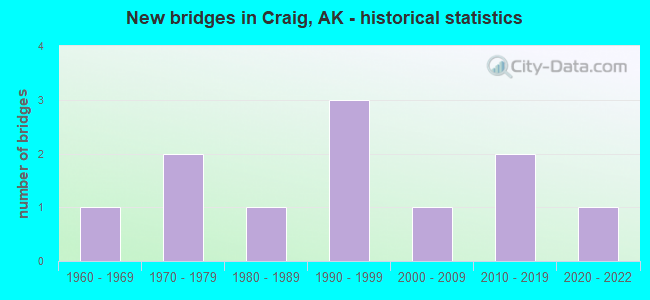
- New bridges - historical statistics
- 11960-1969
- 21970-1979
- 11980-1989
- 31990-1999
- 12000-2009
- 22010-2019
- 12020-2022


- Bridge Condition - Deck
- 20.0%Excellent
- 10.0%Very good
- 40.0%Good
- 20.0%Satisfactory
- 10.0%Fair

- Bridge Condition - Superstructure
- 10.0%Excellent
- 30.0%Very good
- 10.0%Good
- 20.0%Satisfactory
- 20.0%Fair
- 10.0%Poor

- Bridge Condition - Substructure
- 10.0%Excellent
- 20.0%Very good
- 30.0%Good
- 10.0%Satisfactory
- 20.0%Fair
- 10.0%Poor

- Bridge Condition - Channel
- 18.2%Excellent
- 27.3%Very good
- 36.4%Good
- 9.1%Satisfactory
- 9.1%Fair
Find on map >> Show street view
Structure Number: 235, Location: MILE POINT 45.7 (Lat: 64.966633, Lng: -146.234714), Route carried "on" structure: State highway 650, Year Built: 1967, Year Reconstructed: 2009, Status: Open, Structure Length: 3.71m (12.17ft), Average Daily Traffic: 530 (year 2020), Truck Traffic: 9%, Average Future Daily Traffic: 1,710 (year 2039), Design Load: HS 20, Features Intersected: NORTH FORK CHENA RIVER, Facility Carried by Structure: CHENA HOT SPR RD
Minimum Vertical Clearance: 5.03m (16.50ft), Kilometerpoint: 73.531, Lanes on structure: 2, Owner: State Highway Agency, Approaching Roadway Width: 8.2m (26.9ft), Material/Design: Steel, Design/Construction: Stringer/Multi-beam, Number Of Spans In Main Unit: 2, Length of Maximum Span: 18.3m (60.0ft), Curb-To-Curb Width: 8.1m (26.6ft), Out-to-Out Width: 9.0m (29.5ft)
Condition: Deck: Good, Superstructure: Good, Substructure: Good, Channel: Good, Operating Rating: 63.2 metric tons, Method Used To Determine Operating Rating: Load Factor (LF), Inventory Rating: 29.1 metric tons, Method Used To Determine Inventory Rating: Load Factor (LF), Structural Evaluation: Better than present minimum criteria, Deck Geometry: Somewhat better than minimum adequacy, Waterway Adequacy: Equal to present minimum criteria, Approach Roadway Alignment: Equal to present desirable criteria, Designated Inspection Frequency: Every 24 months, Inspection Date: August 2020, Deck Structure Type: Concrete Cast-file-Place, Wearing Surface/Protective System: Wearing Surface: Monolithic Concrete
Find on map >> Show street view
Structure Number: 263, Location: MILE POINT 0.4 (Lat: 64.842364, Lng: -147.812619), Route carried "on" structure: State highway 617, Year Built: 2021, Status: Open, Structure Length: 8.53m (27.99ft), Average Daily Traffic: 14,700 (year 2020), Truck Traffic: 7%, Average Future Daily Traffic: 18,800 (year 2039), Design Load: HL 93, Features Intersected: CHENA RIVER (UNIV AVE), Facility Carried by Structure: UNIVERSITY AVE
Minimum Vertical Clearance: 5.56m (18.24ft), Kilometerpoint: 0.644, Lanes on structure: 4, Base Highway Network: Yes, Owner: State Highway Agency, Approaching Roadway Width: 21.0m (68.9ft), Skew: 21 degrees, Navigation Control: Yes ( Vertical Clearance: 1.8m (5.9ft), Horizontal Clearance: 26.5m (86.9ft)), Material/Design: Prestressed concrete, Design/Construction: Tee Beam, Number Of Spans In Main Unit: 3, Length of Maximum Span: 35.7m (117.1ft), Curb or Sidewalk Widths: Left: 1.8m (5.9ft), Right: 2.4m (7.9ft), Curb-To-Curb Width: 21.0m (68.9ft), Out-to-Out Width: 26.9m (88.3ft)
Condition: Deck: Excellent, Superstructure: Excellent, Substructure: Excellent, Channel: Very good, Operating Rating: 98.2 metric tons, Method Used To Determine Operating Rating: Load Factor (LF), Inventory Rating: 48.7 metric tons, Method Used To Determine Inventory Rating: Load Factor (LF), Structural Evaluation: Superior to present desirable criteria, Deck Geometry: Superior to present desirable criteria, Waterway Adequacy: Equal to present desirable criteria, Approach Roadway Alignment: Equal to present desirable criteria, Designated Inspection Frequency: Every 24 months, Inspection Date: September 2021, Deck Structure Type: Other, Wearing Surface/Protective System: Wearing Surface: Bituminous, Membrane: Other, Deck Protection: Epoxy Coated Reinforcing
Find on map >> Show street view
Structure Number: 287, Location: MILE POINT 18.4 (Lat: 57.586797, Lng: -152.470472), Route carried "on" structure: State highway 391, Year Built: 1974, Status: Open, Structure Length: 4.78m (15.68ft), Average Daily Traffic: 470 (year 2020), Truck Traffic: 15%, Average Future Daily Traffic: 1,300 (year 2039), Design Load: HS 20, Features Intersected: OLDS RIVER, Facility Carried by Structure: CHINIAK HIGHWAY
Minimum Vertical Clearance: 30+ m (98+ ft), Kilometerpoint: 29.580, Lanes on structure: 2, Owner: State Highway Agency, Approaching Roadway Width: 9.1m (29.9ft), Material/Design: Prestressed concrete, Design/Construction: Tee Beam, Number Of Spans In Main Unit: 5, Length of Maximum Span: 9.4m (30.8ft), Curb-To-Curb Width: 7.2m (23.6ft), Out-to-Out Width: 8.5m (27.9ft)
Condition: Deck: Satisfactory, Superstructure: Satisfactory, Substructure: Good, Channel: Good, Operating Rating: 84.3 metric tons, Method Used To Determine Operating Rating: Load Factor (LF), Inventory Rating: 38.6 metric tons, Method Used To Determine Inventory Rating: Load Factor (LF), Structural Evaluation: Equal to present minimum criteria, Deck Geometry: Meets minimum limits, Waterway Adequacy: Better than present minimum criteria, Approach Roadway Alignment: Equal to present desirable criteria, Designated Inspection Frequency: Every 24 months, Inspection Date: September 2020, Deck Structure Type: Other, Wearing Surface/Protective System: Wearing Surface: Bituminous, Membrane: Preformed Fabric
Find on map >> Show street view
Structure Number: 579, Location: MILE POINT 204.3 (Lat: 63.211600, Lng: -145.639000), Route carried "on" structure: State highway 71, Year Built: 2014, Status: Open, Structure Length: 3.66m (12.01ft), Average Daily Traffic: 280 (year 2020), Truck Traffic: 21%, Average Future Daily Traffic: 330 (year 2039), Design Load: HL 93, Features Intersected: PHELAN CREEK, Facility Carried by Structure: RICHARDSON HIGHWAY
Minimum Vertical Clearance: 5.46m (17.91ft), Kilometerpoint: 328.749, Lanes on structure: 2, Base Highway Network: Yes, Owner: State Highway Agency, Approaching Roadway Width: 11.0m (36.1ft), Skew: 3 degrees, Material/Design: Prestressed concrete, Design/Construction: Tee Beam, Number Of Spans In Main Unit: 1, Length of Maximum Span: 35.7m (117.1ft), Curb-To-Curb Width: 11.0m (36.1ft), Out-to-Out Width: 11.9m (39.0ft)
Condition: Deck: Excellent, Superstructure: Very good, Substructure: Very good, Channel: Excellent, Operating Rating: 87.7 metric tons, Method Used To Determine Operating Rating: Load Factor (LF), Inventory Rating: 40.4 metric tons, Method Used To Determine Inventory Rating: Load Factor (LF), Structural Evaluation: Equal to present desirable criteria, Deck Geometry: Equal to present desirable criteria, Waterway Adequacy: Superior to present desirable criteria, Approach Roadway Alignment: Superior to present desirable criteria, Designated Inspection Frequency: Every 24 months, Inspection Date: July 2021, Deck Structure Type: Other, Wearing Surface/Protective System: Wearing Surface: Bituminous, Membrane: Preformed Fabric, Deck Protection: Epoxy Coated Reinforcing
Find on map >> Show street view
Structure Number: 658, Location: OLD TOK ALIGNMENT MP0.0 (Lat: 62.960278, Lng: -143.353333), Route carried "on" structure: State highway NSP00, Year Built: 1979, Status: Posted for load, Structure Length: 2.56m (8.40ft), Average Daily Traffic: 336 (year 2018), Truck Traffic: 21%, Average Future Daily Traffic: 400 (year 2035), Design Load: H 20, Features Intersected: LITTLE TOK RIVER, Facility Carried by Structure: 91 MILE LOOP
Minimum Vertical Clearance: 30+ m (98+ ft), Kilometerpoint: 0.000, Lanes on structure: 2, Owner: State Highway Agency, Approaching Roadway Width: 8.5m (27.9ft), Material/Design: Steel, Design/Construction: Stringer/Multi-beam, Number Of Spans In Main Unit: 1, Length of Maximum Span: 12.8m (42.0ft), Curb or Sidewalk Widths: Left: 0.3m (1.0ft), Right: 0.3m (1.0ft), Curb-To-Curb Width: 6.9m (22.6ft), Out-to-Out Width: 7.4m (24.3ft)
Condition: Deck: Good, Superstructure: Poor, Substructure: Fair, Channel: Very good, Operating Rating: 69.1 metric tons, Method Used To Determine Operating Rating: Load Factor (LF), Inventory Rating: 20.0 metric tons, Method Used To Determine Inventory Rating: Load Factor (LF), Structural Evaluation: Meets minimum limits, Deck Geometry: Meets minimum limits, Waterway Adequacy: Better than present minimum criteria, Approach Roadway Alignment: Equal to present minimum criteria, Bridge Posting: Required (Relationship of Operating Rating to Maximum Legal Load: > 39.9% below), Designated Inspection Frequency: Every 24 months, Other Special Inspection Frequency: Every 60 months, Inspection Date: July 2021, Other Special Inspection Date: July 2019, Deck Structure Type: Wood or Timber, Wearing Surface/Protective System: Wearing Surface: Bituminous, Deck Protection: Other
Find on map >> Show street view
Structure Number: 2089, Location: MILE POINT 5.0 (Lat: 55.456411, Lng: -133.033056), Route carried "on" structure: City street , Year Built: 2015, Status: Open, Structure Length: 3.05m (10.01ft), Average Daily Traffic: 175 (year 2018), Truck Traffic: 7%, Average Future Daily Traffic: 300 (year 2035), Design Load: HL 93, Features Intersected: DOG SALMON CREEK, Facility Carried by Structure: PORT ST NICHOLAS
Minimum Vertical Clearance: 30+ m (98+ ft), Kilometerpoint: 8.159, Lanes on structure: 2, Owner: City or Municipal Highway Agency, Approaching Roadway Width: 8.8m (28.9ft), Skew: 3 degrees, Material/Design: Steel, Design/Construction: Stringer/Multi-beam, Number Of Spans In Main Unit: 1, Length of Maximum Span: 30.5m (100.1ft), Curb-To-Curb Width: 8.5m (27.9ft), Out-to-Out Width: 9.4m (30.8ft)
Condition: Deck: Good, Superstructure: Very good, Substructure: Very good, Channel: Excellent, Inventory Rating: 38.4 metric tons, Method Used To Determine Inventory Rating: Load Factor (LF), Structural Evaluation: Equal to present desirable criteria, Deck Geometry: Equal to present minimum criteria, Waterway Adequacy: Equal to present desirable criteria, Approach Roadway Alignment: Equal to present minimum criteria, Designated Inspection Frequency: Every 24 months, Inspection Date: July 2021, Deck Structure Type: Concrete Cast-file-Place, Wearing Surface/Protective System: Wearing Surface: Monolithic Concrete, Deck Protection: Epoxy Coated Reinforcing
Find on map >> Show street view
Structure Number: 4008, Location: MILE POINT 1.5 (Lat: 55.484444, Lng: -133.125278), Route carried "on" structure: State highway 924, Year Built: 1985, Status: Open, Structure Length: 0.79m (2.59ft), Average Daily Traffic: 1,200 (year 2020), Truck Traffic: 10%, Average Future Daily Traffic: 1,460 (year 2039), Features Intersected: CRAB CREEK CULVERT, Facility Carried by Structure: CRAIG/KLAWOCK/HOLL
Minimum Vertical Clearance: 30+ m (98+ ft), Kilometerpoint: 2.472, Lanes on structure: 2, Owner: State Highway Agency, Approaching Roadway Width: 10.4m (34.1ft), Material/Design: Aluminum, Iron, Design/Construction: Culvert, Number Of Spans In Main Unit: 1, Length of Maximum Span: 6.1m (20.0ft)
Condition: Channel: Fair, Culverts: Poor, Structural Evaluation: Meets minimum limits, Waterway Adequacy: Superior to present desirable criteria, Approach Roadway Alignment: Equal to present desirable criteria, Designated Inspection Frequency: Every 24 months, Inspection Date: July 2021
Find on map >> Show street view
Structure Number: E09108T052, Location: 9.7KM EAST OF CRAIG (Lat: 55.496519, Lng: -132.985231), Route carried "on" structure: Federal lands road 8, Year Built: 2005, Status: Open, Structure Length: 1.69m (5.54ft), Average Daily Traffic: 1 (year 2019), Average Future Daily Traffic: 2 (year 2039), Design Load: HS 20, Features Intersected: UNNAMED CREEK
Minimum Vertical Clearance: 30+ m (98+ ft), Kilometerpoint: 6.100, Lanes on structure: 1, Owner: Indian Tribal Government, Approaching Roadway Width: 3.0m (9.8ft), Material/Design: Steel, Design/Construction: Stringer/Multi-beam, Number Of Spans In Main Unit: 1, Length of Maximum Span: 16.6m (54.5ft), Curb-To-Curb Width: 4.3m (14.1ft), Out-to-Out Width: 4.3m (14.1ft)
Condition: Deck: Very good, Superstructure: Very good, Substructure: Fair, Channel: Satisfactory, Operating Rating: 35.0 metric tons, Method Used To Determine Operating Rating: Load Factor (LF), Inventory Rating: 25.7 metric tons, Method Used To Determine Inventory Rating: Load Factor (LF), Structural Evaluation: Somewhat better than minimum adequacy, Deck Geometry: Equal to present minimum criteria, Waterway Adequacy: Better than present minimum criteria, Approach Roadway Alignment: Meets minimum limits, Designated Inspection Frequency: Every 24 months, Inspection Date: June 2019, Deck Structure Type: Corrugated Steel, Wearing Surface/Protective System: Wearing Surface: Wood or Timber
Find on map >> Show street view
Structure Number: E09108T053, Location: 9.9KM EAST OF CRAIG (Lat: 55.496231, Lng: -132.983631), Route carried "on" structure: Federal lands road 8, Year Built: 1990, Status: Open, Structure Length: 1.37m (4.49ft), Average Daily Traffic: 1 (year 2019), Average Future Daily Traffic: 2 (year 2039), Features Intersected: UNNAMED STREAM
Minimum Vertical Clearance: 30+ m (98+ ft), Kilometerpoint: 6.000, Lanes on structure: 1, Owner: Indian Tribal Government, Approaching Roadway Width: 3.0m (9.8ft), Material/Design: Steel, Design/Construction: Mixed types, Number Of Spans In Main Unit: 1, Length of Maximum Span: 13.4m (44.0ft), Curb or Sidewalk Widths: Left: 0.2m (0.7ft), Right: 0.2m (0.7ft), Curb-To-Curb Width: 4.4m (14.4ft), Out-to-Out Width: 4.8m (15.7ft)
Condition: Deck: Satisfactory, Superstructure: Satisfactory, Substructure: Good, Channel: Good, Inventory Rating: 94.3 metric tons, Method Used To Determine Inventory Rating: Load Factor (LF), Structural Evaluation: Equal to present minimum criteria, Deck Geometry: Equal to present minimum criteria, Waterway Adequacy: Better than present minimum criteria, Approach Roadway Alignment: Equal to present minimum criteria, Designated Inspection Frequency: Every 24 months, Inspection Date: June 2019, Deck Structure Type: Wood or Timber, Wearing Surface/Protective System: Wearing Surface: Wood or Timber
Find on map >> Show street view
Structure Number: E09108T054, Location: 10.4KM EAST OF CRIAG (Lat: 55.495317, Lng: -132.976011), Route carried "on" structure: Federal lands road 8, Year Built: 1990, Status: Open, Structure Length: 0.88m (2.89ft), Average Daily Traffic: 1 (year 2019), Average Future Daily Traffic: 2 (year 2039), Features Intersected: UNNAMED STREAM
Minimum Vertical Clearance: 30+ m (98+ ft), Kilometerpoint: 5.500, Lanes on structure: 1, Owner: Indian Tribal Government, Approaching Roadway Width: 3.0m (9.8ft), Material/Design: Wood or Timber, Design/Construction: Stringer/Multi-beam, Number Of Spans In Main Unit: 1, Length of Maximum Span: 7.6m (24.9ft), Curb-To-Curb Width: 3.0m (9.8ft), Out-to-Out Width: 3.4m (11.2ft)
Condition: Deck: Fair, Superstructure: Fair, Substructure: Satisfactory, Channel: Very good, Operating Rating: 97.2 metric tons, Method Used To Determine Operating Rating: Load Factor (LF), Inventory Rating: 15.1 metric tons, Method Used To Determine Inventory Rating: Load Factor (LF), Structural Evaluation: Meets minimum limits, Deck Geometry: High priority of replacement, Waterway Adequacy: Equal to present minimum criteria, Approach Roadway Alignment: Equal to present desirable criteria, Designated Inspection Frequency: Every 24 months, Inspection Date: June 2019, Deck Structure Type: Wood or Timber, Wearing Surface/Protective System: Wearing Surface: Wood or Timber
Find on map >> Show street view
Structure Number: E09108T055, Location: 10.5KM EAST OF CRAIG (Lat: 55.494414, Lng: -132.972275), Route carried "on" structure: Federal lands road 8, Year Built: 1990, Status: Open, Structure Length: 0.80m (2.62ft), Average Daily Traffic: 1 (year 2019), Average Future Daily Traffic: 2 (year 2039), Features Intersected: UNNAMED STREAM
Minimum Vertical Clearance: 30+ m (98+ ft), Kilometerpoint: 5.200, Lanes on structure: 1, Owner: Indian Tribal Government, Approaching Roadway Width: 3.0m (9.8ft), Material/Design: Wood or Timber, Design/Construction: Stringer/Multi-beam, Number Of Spans In Main Unit: 1, Length of Maximum Span: 7.0m (23.0ft), Curb-To-Curb Width: 3.0m (9.8ft), Out-to-Out Width: 3.5m (11.5ft)
Condition: Deck: Good, Superstructure: Fair, Substructure: Poor, Channel: Good, Operating Rating: 20.3 metric tons, Method Used To Determine Operating Rating: Load Factor (LF), Inventory Rating: 3.6 metric tons, Method Used To Determine Inventory Rating: Load Factor (LF), Structural Evaluation: High priority of replacement, Deck Geometry: High priority of replacement, Waterway Adequacy: Equal to present desirable criteria, Approach Roadway Alignment: Equal to present minimum criteria, Bridge Posting: Required (Relationship of Operating Rating to Maximum Legal Load: > 39.9% below), Length Of Structure Improvement: 1.00m (3.28ft), Designated Inspection Frequency: Every 24 months, Inspection Date: June 2019, Bridge Improvement Cost: $400,000, Roadway Improvement Cost: $100,000, Total Project Cost: $560,000 ( Estimate for 2019), Deck Structure Type: Wood or Timber, Wearing Surface/Protective System: Wearing Surface: Gravel