Bridge Statistics for Cranbury, New Jersey (NJ)
Condition, Traffic, Stress, Structural Evaluation, Project Costs
- National Bridge Inventory (NBI) Statistics
- 18Number of bridges
- 154ft / 46.5mTotal length
- $2,074,000Total costs
- 760,405Total average daily traffic
- 89,394Total average daily truck traffic
- National Bridge Inventory (NBI) Registered Bridges for Cranbury
- No street view available for this location
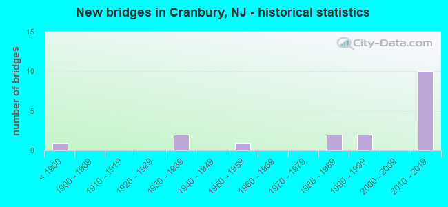
- New bridges - historical statistics
- 1Before 1900
- 21930-1939
- 11950-1959
- 21980-1989
- 21990-1999
- 102010-2019

- Reconstructed bridges - Historical Statistics
- 11940-1949
- 01950-1959
- 01960-1969
- 01970-1979
- 11980-1989
- 11990-1999


- Bridge Condition - Deck
- 9.1%Very good
- 54.5%Good
- 9.1%Satisfactory
- 18.2%Fair
- 9.1%Poor

- Bridge Condition - Superstructure
- 45.5%Very good
- 18.2%Good
- 9.1%Satisfactory
- 18.2%Fair
- 9.1%Poor

- Bridge Condition - Substructure
- 45.5%Very good
- 27.3%Good
- 9.1%Satisfactory
- 9.1%Fair
- 9.1%Poor

- Bridge Condition - Channel
- 10.0%Excellent
- 10.0%Very good
- 20.0%Good
- 40.0%Satisfactory
- 20.0%Fair

- Bridge Condition - Culverts
- 66.7%Satisfactory
- 33.3%Fair
Find on map >> Show street view
Structure Number: 1123153, Location: 0.66 Mi. N of Rt 133 Jct (Lat: 40.290119, Lng: -74.521889), Route carried "on" structure: US 130, Year Built: 1936, Year Reconstructed: 1947, Status: Open, Structure Length: 1.68m (5.51ft), Average Daily Traffic: 34,041 (year 2020), Truck Traffic: 4%, Average Future Daily Traffic: 40,849 (year 2040), Features Intersected: MILLSTONE RIVER
Minimum Vertical Clearance: 30+ m (98+ ft), Kilometerpoint: 112.718, Lanes on structure: 4, Base Highway Network: Yes, Owner: State Highway Agency, Approaching Roadway Width: 27.4m (89.9ft), Skew: 20 degrees, Material/Design: Steel, Design/Construction: Stringer/Multi-beam, Number Of Spans In Main Unit: 1, Length of Maximum Span: 16.2m (53.1ft), Curb or Sidewalk Widths: Left: 1.8m (5.9ft), Right: 1.8m (5.9ft), Curb-To-Curb Width: 27.6m (90.6ft), Out-to-Out Width: 31.9m (104.7ft)
Condition: Deck: Fair, Superstructure: Fair, Substructure: Poor, Channel: Good, Operating Rating: 59.0 metric tons, Method Used To Determine Operating Rating: Load Factor (LF), Inventory Rating: 35.4 metric tons, Method Used To Determine Inventory Rating: Load Factor (LF), Structural Evaluation: Meets minimum limits, Deck Geometry: Superior to present desirable criteria, Waterway Adequacy: Superior to present desirable criteria, Approach Roadway Alignment: Equal to present desirable criteria, Length Of Structure Improvement: 1.68m (5.51ft), Designated Inspection Frequency: Every 24 months, Underwater Inspection Frequency: Every 24 months, Inspection Date: August 2020, Underwater Inspection Date: July 2020, Bridge Improvement Cost: $87,000, Roadway Improvement Cost: $1,000, Total Project Cost: $508,000 ( Estimate for 2018), Deck Structure Type: Concrete Cast-file-Place, Wearing Surface/Protective System: Wearing Surface: Monolithic Concrete
Find on map >> Show street view
Structure Number: 1227151, Location: 0.5 MI S OF 130-535 JCT (Lat: 40.310439, Lng: -74.509631), Route carried "on" structure: US 130, Year Built: 1935, Status: Open, Structure Length: 1.40m (4.59ft), Average Daily Traffic: 39,521 (year 2021), Truck Traffic: 4%, Average Future Daily Traffic: 48,223 (year 2041), Features Intersected: BRAINERD LAKE
Minimum Vertical Clearance: 30+ m (98+ ft), Kilometerpoint: 115.245, Lanes on structure: 4, Base Highway Network: Yes, Owner: State Highway Agency, Approaching Roadway Width: 27.4m (89.9ft), Material/Design: Concrete, Design/Construction: Frame, Number Of Spans In Main Unit: 1, Length of Maximum Span: 12.2m (40.0ft), Curb or Sidewalk Widths: Left: 1.7m (5.6ft), Right: 1.7m (5.6ft), Curb-To-Curb Width: 27.4m (89.9ft), Out-to-Out Width: 31.6m (103.7ft)
Condition: Deck: Fair, Superstructure: Fair, Substructure: Fair, Channel: Satisfactory, Inventory Rating: 62.6 metric tons, Method Used To Determine Inventory Rating: Load Factor (LF), Structural Evaluation: Somewhat better than minimum adequacy, Deck Geometry: Superior to present desirable criteria, Waterway Adequacy: Superior to present desirable criteria, Approach Roadway Alignment: Equal to present desirable criteria, Designated Inspection Frequency: Every 24 months, Underwater Inspection Frequency: Every 48 months, Inspection Date: May 2021, Underwater Inspection Date: May 2019, Deck Structure Type: Concrete Cast-file-Place, Wearing Surface/Protective System: Wearing Surface: Bituminous
Find on map >> Show street view
Structure Number: 124B098, Location: 1 MI SOUTH OF TRENTON RD (Lat: 40.293081, Lng: -74.526800), Route carried "on" structure: City street , Year Built: 1982, Status: Open, Structure Length: 1.98m (6.50ft), Average Daily Traffic: 1,575 (year 2021), Truck Traffic: 1%, Average Future Daily Traffic: 1,925 (year 2041), Design Load: HS 20+Mod, Features Intersected: MILLSTONE RIVER, Facility Carried by Structure: OLD CRANBURY RD
Minimum Vertical Clearance: 30+ m (98+ ft), Kilometerpoint: 0.000, Lanes on structure: 2, Owner: County Highway Agency, Approaching Roadway Width: 9.1m (29.9ft), Material/Design: Prestressed concrete, Design/Construction: Box Beam or Girders - Multiple, Number Of Spans In Main Unit: 1, Length of Maximum Span: 18.6m (61.0ft), Curb or Sidewalk Widths: Left: 1.2m (3.9ft), Right: 0.5m (1.6ft), Curb-To-Curb Width: 9.1m (29.9ft), Out-to-Out Width: 11.5m (37.7ft)
Condition: Deck: Poor, Superstructure: Poor, Substructure: Good, Channel: Fair, Operating Rating: 81.6 metric tons, Method Used To Determine Operating Rating: Load Factor (LF), Inventory Rating: 48.1 metric tons, Method Used To Determine Inventory Rating: Load Factor (LF), Structural Evaluation: Meets minimum limits, Deck Geometry: Somewhat better than minimum adequacy, Waterway Adequacy: Equal to present minimum criteria, Approach Roadway Alignment: Equal to present minimum criteria, Length Of Structure Improvement: 1.98m (6.50ft), Designated Inspection Frequency: Every 24 months, Underwater Inspection Frequency: Every 24 months, Inspection Date: April 2021, Underwater Inspection Date: April 2021, Bridge Improvement Cost: $888,000, Roadway Improvement Cost: $39,000, Total Project Cost: $1,092,000 ( Estimate for 2021), Deck Structure Type: Concrete Cast-file-Place, Wearing Surface/Protective System: Wearing Surface: Low Slump Concrete
Find on map >> Show street view
Structure Number: 124B104, Location: 0.2 MI. SW OF JCT RT.130 (Lat: 40.326250, Lng: -74.508719), Route carried "on" structure: Business City street , Year Built: 1992, Status: Open, Structure Length: 0.73m (2.40ft), Average Daily Traffic: 2,460 (year 2021), Truck Traffic: 3%, Average Future Daily Traffic: 3,005 (year 2041), Design Load: HS 20+Mod, Features Intersected: CEDAR BROOK, Facility Carried by Structure: MAIN STREET
Minimum Vertical Clearance: 30+ m (98+ ft), Kilometerpoint: 0.241, Lanes on structure: 2, Owner: County Highway Agency, Approaching Roadway Width: 7.3m (24.0ft), Skew: 3 degrees, Material/Design: Concrete, Design/Construction: Culvert, Number Of Spans In Main Unit: 1, Length of Maximum Span: 7.3m (24.0ft)
Condition: Channel: Satisfactory, Culverts: Satisfactory, Operating Rating: 73.4 metric tons, Method Used To Determine Operating Rating: Load Factor (LF), Inventory Rating: 44.0 metric tons, Method Used To Determine Inventory Rating: Load Factor (LF), Structural Evaluation: Equal to present minimum criteria, Waterway Adequacy: Equal to present desirable criteria, Approach Roadway Alignment: Equal to present desirable criteria, Designated Inspection Frequency: Every 24 months, Inspection Date: April 2021
Find on map >> Show street view
Structure Number: 124B105, Location: 0.25 MI N OF STATION RD (Lat: 40.309769, Lng: -74.516719), Route carried "on" structure: County highway 535, Year Built: 1896, Year Reconstructed: 1986, Status: Open, Structure Length: 0.70m (2.30ft), Average Daily Traffic: 9,895 (year 2021), Truck Traffic: 4%, Average Future Daily Traffic: 12,075 (year 2041), Features Intersected: CRANBURY BROOK
Minimum Vertical Clearance: 30+ m (98+ ft), Kilometerpoint: 22.643, Lanes on structure: 2, Owner: County Highway Agency, Approaching Roadway Width: 9.1m (29.9ft), Material/Design: Masonry, Design/Construction: Culvert, Number Of Spans In Main Unit: 1, Length of Maximum Span: 7.0m (23.0ft), Curb or Sidewalk Widths: Left: 1.8m (5.9ft), Right: 1.5m (4.9ft)
Condition: Channel: Fair, Culverts: Satisfactory, Operating Rating: 53.5 metric tons, Method Used To Determine Operating Rating: Field evaluation and documented engineering judgment, Inventory Rating: 31.8 metric tons, Method Used To Determine Inventory Rating: Field evaluation and documented engineering judgment, Structural Evaluation: Equal to present minimum criteria, Waterway Adequacy: Equal to present minimum criteria, Approach Roadway Alignment: Equal to present desirable criteria, Designated Inspection Frequency: Every 24 months, Inspection Date: April 2021
Find on map >> Show street view
Structure Number: 124B106, Location: 0.34 MI S OF US 130 JCT (Lat: 40.286539, Lng: -74.520869), Route carried "on" structure: County highway 539, Year Built: 1993, Status: Open, Structure Length: 2.04m (6.69ft), Average Daily Traffic: 7,562 (year 2021), Truck Traffic: 3%, Average Future Daily Traffic: 9,225 (year 2041), Design Load: HS 25 or greater, Features Intersected: MILLSTONE RIVER, Facility Carried by Structure: N MAIN STREET
Minimum Vertical Clearance: 30+ m (98+ ft), Kilometerpoint: 85.585, Lanes on structure: 2, Owner: County Highway Agency, Approaching Roadway Width: 15.2m (49.9ft), Material/Design: Prestressed concrete, Design/Construction: Box Beam or Girders - Multiple, Number Of Spans In Main Unit: 1, Length of Maximum Span: 19.5m (64.0ft), Curb or Sidewalk Widths: Left: 1.5m (4.9ft), Right: 1.5m (4.9ft), Curb-To-Curb Width: 15.2m (49.9ft), Out-to-Out Width: 18.9m (62.0ft)
Condition: Deck: Satisfactory, Superstructure: Satisfactory, Substructure: Good, Channel: Satisfactory, Operating Rating: 62.6 metric tons, Method Used To Determine Operating Rating: Load Factor (LF), Inventory Rating: 37.2 metric tons, Method Used To Determine Inventory Rating: Load Factor (LF), Structural Evaluation: Equal to present minimum criteria, Deck Geometry: Superior to present desirable criteria, Waterway Adequacy: Equal to present desirable criteria, Approach Roadway Alignment: Equal to present desirable criteria, Designated Inspection Frequency: Every 24 months, Inspection Date: May 2021, Deck Structure Type: Concrete Cast-file-Place, Wearing Surface/Protective System: Wearing Surface: Monolithic Concrete, Deck Protection: Epoxy Coated Reinforcing
Find on map >> Show street view
Structure Number: 125B172, Location: 0.05 MI S OF CR 614 (Lat: 40.325919, Lng: -74.498689), Route carried "on" structure: County highway 535, Year Built: 1983, Year Reconstructed: 2003, Status: Open, Structure Length: 0.61m (2.00ft), Average Daily Traffic: 15,205 (year 2021), Truck Traffic: 4%, Average Future Daily Traffic: 18,555 (year 2041), Design Load: HS 20+Mod, Features Intersected: CEDAR BROOK, Facility Carried by Structure: CRANBURY S RIVERRD
Minimum Vertical Clearance: 30+ m (98+ ft), Kilometerpoint: 25.299, Lanes on structure: 5, Base Highway Network: Yes, Owner: County Highway Agency, Approaching Roadway Width: 23.6m (77.4ft), Material/Design: Concrete, Design/Construction: Culvert, Number Of Spans In Main Unit: 1, Length of Maximum Span: 6.1m (20.0ft), Curb or Sidewalk Widths: Left: 1.3m (4.3ft), Right: 1.5m (4.9ft), Curb-To-Curb Width: 23.6m (77.4ft), Out-to-Out Width: 27.2m (89.2ft)
Condition: Channel: Satisfactory, Culverts: Fair, Operating Rating: 64.4 metric tons, Method Used To Determine Operating Rating: Load Factor (LF), Inventory Rating: 38.6 metric tons, Method Used To Determine Inventory Rating: Load Factor (LF), Structural Evaluation: Somewhat better than minimum adequacy, Deck Geometry: Better than present minimum criteria, Waterway Adequacy: Equal to present minimum criteria, Approach Roadway Alignment: Equal to present desirable criteria, Designated Inspection Frequency: Every 24 months, Inspection Date: April 2021, Deck Structure Type: Concrete Cast-file-Place, Wearing Surface/Protective System: Wearing Surface: Monolithic Concrete, Deck Protection: Epoxy Coated Reinforcing
Find on map >> Show street view
Structure Number: M06985N, Location: 2.1 MI NORTH OF EXIT 8 (Lat: 40.296722, Lng: -74.496922), Route carried "on" structure: Interstate 95, Year Built: 2013, Status: Open, Structure Length: 7.71m (25.30ft), Average Daily Traffic: 39,317 (year 2021), Truck Traffic: 21%, Average Future Daily Traffic: 47,974 (year 2041), Design Load: HL 93, Features Intersected: HIGHTSTOWN-CRANBURY ROAD, Facility Carried by Structure: SNO ROADWAY
Minimum Vertical Clearance: 30+ m (98+ ft), Kilometerpoint: 39.445, Lanes on structure: 3, Lanes under structure: 2, Base Highway Network: Yes, Toll: On toll road, Owner: State Toll Authority, Approaching Roadway Width: 16.2m (53.1ft), Skew: 7 degrees, Material/Design: Steel, Design/Construction: Stringer/Multi-beam, Number Of Spans In Main Unit: 2, Length of Maximum Span: 37.8m (124.0ft), Curb-To-Curb Width: 16.8m (55.1ft), Out-to-Out Width: 18.0m (59.1ft)
Condition: Deck: Good, Superstructure: Very good, Substructure: Very good, Operating Rating: 50.2 metric tons, Method Used To Determine Operating Rating: Load and Resistance Factor Rating (LRFR) rating reported by rating factor(RF) method using HL-93 loadings, Inventory Rating: 38.9 metric tons, Method Used To Determine Inventory Rating: Load and Resistance Factor Rating (LRFR) rating reported by rating factor(RF) method using HL-93 loadings, Structural Evaluation: Equal to present desirable criteria, Deck Geometry: Equal to present minimum criteria, Underclear: High priority of corrective action, Approach Roadway Alignment: Equal to present desirable criteria, Length Of Structure Improvement: 7.56m (24.80ft), Designated Inspection Frequency: Every 24 months, Inspection Date: June 2021, Bridge Improvement Cost: $142,000, Roadway Improvement Cost: $30,000, Total Project Cost: $237,000 ( Estimate for 2017), Deck Structure Type: Concrete Cast-file-Place, Wearing Surface/Protective System: Deck Protection: Epoxy Coated Reinforcing
Find on map >> Show street view
Structure Number: M06985R, Location: 2 MI NORTH OF INT 8 (Lat: 40.295831, Lng: -74.497722), Route carried "on" structure: Interstate 95, Year Built: 2014, Status: Open, Structure Length: 7.56m (24.80ft), Average Daily Traffic: 123,096 (year 2021), Truck Traffic: 1%, Average Future Daily Traffic: 150,200 (year 2041), Design Load: HL 93, Features Intersected: Hightstown-Cranbury Road, Facility Carried by Structure: NSI & SNI Roadways
Minimum Vertical Clearance: 30+ m (98+ ft), Kilometerpoint: 39.445, Lanes on structure: 6, Lanes under structure: 2, Base Highway Network: Yes, Toll: On toll road, Owner: State Toll Authority, Approaching Roadway Width: 36.9m (121.1ft), Skew: 17 degrees, Material/Design: Steel continuous, Design/Construction: Stringer/Multi-beam, Number Of Spans In Main Unit: 2, Length of Maximum Span: 38.1m (125.0ft), Curb-To-Curb Width: 36.9m (121.1ft), Out-to-Out Width: 39.0m (128.0ft)
Condition: Deck: Good, Superstructure: Good, Substructure: Good, Operating Rating: 53.1 metric tons, Method Used To Determine Operating Rating: Load and Resistance Factor Rating (LRFR) rating reported by rating factor(RF) method using HL-93 loadings, Inventory Rating: 40.8 metric tons, Method Used To Determine Inventory Rating: Load and Resistance Factor Rating (LRFR) rating reported by rating factor(RF) method using HL-93 loadings, Structural Evaluation: Better than present minimum criteria, Deck Geometry: Superior to present desirable criteria, Underclear: High priority of corrective action, Approach Roadway Alignment: Equal to present desirable criteria, Designated Inspection Frequency: Every 24 months, Inspection Date: August 2021, Deck Structure Type: Concrete Cast-file-Place, Wearing Surface/Protective System: Deck Protection: Epoxy Coated Reinforcing
Find on map >> Show street view
Structure Number: M06985S, Location: 2.1 MI NORTH OF EXIT 8 (Lat: 40.294789, Lng: -74.498686), Route carried "on" structure: Interstate 95, Year Built: 2013, Status: Open, Structure Length: 7.77m (25.49ft), Average Daily Traffic: 39,317 (year 2021), Truck Traffic: 22%, Average Future Daily Traffic: 47,974 (year 2041), Design Load: HL 93, Features Intersected: HIGHTSTOWN-CRANBURY ROAD, Facility Carried by Structure: NSO ROADWAY
Minimum Vertical Clearance: 30+ m (98+ ft), Kilometerpoint: 39.445, Lanes on structure: 3, Lanes under structure: 2, Base Highway Network: Yes, Toll: On toll road, Owner: State Toll Authority, Approaching Roadway Width: 16.8m (55.1ft), Skew: 7 degrees, Material/Design: Steel, Design/Construction: Stringer/Multi-beam, Number Of Spans In Main Unit: 2, Length of Maximum Span: 38.1m (125.0ft), Curb-To-Curb Width: 16.8m (55.1ft), Out-to-Out Width: 18.0m (59.1ft)
Condition: Deck: Good, Superstructure: Very good, Substructure: Very good, Operating Rating: 48.3 metric tons, Method Used To Determine Operating Rating: Load and Resistance Factor Rating (LRFR) rating reported by rating factor(RF) method using HL-93 loadings, Inventory Rating: 37.3 metric tons, Method Used To Determine Inventory Rating: Load and Resistance Factor Rating (LRFR) rating reported by rating factor(RF) method using HL-93 loadings, Structural Evaluation: Equal to present desirable criteria, Deck Geometry: Equal to present minimum criteria, Underclear: High priority of corrective action, Approach Roadway Alignment: Equal to present desirable criteria, Length Of Structure Improvement: 7.77m (25.49ft), Designated Inspection Frequency: Every 24 months, Inspection Date: June 2021, Bridge Improvement Cost: $142,000, Roadway Improvement Cost: $30,000, Total Project Cost: $237,000 ( Estimate for 2017), Deck Structure Type: Concrete Cast-file-Place, Wearing Surface/Protective System: Deck Protection: Epoxy Coated Reinforcing
Find on map >> Show street view
Structure Number: M07048R, Location: 2.2 MI N RTE 33 & NJ TPK (Lat: 40.304492, Lng: -74.493894), Route carried "on" structure: County highway 615, Year Built: 2013, Status: Open, Structure Length: 10.33m (33.89ft), Average Daily Traffic: 6,694 (year 2021), Truck Traffic: 4%, Average Future Daily Traffic: 8,168 (year 2041), Design Load: HL 93, Features Intersected: NJTPK(I-95), Facility Carried by Structure: CRANBURY STATION R
Minimum Vertical Clearance: 30+ m (98+ ft), Kilometerpoint: 8.352, Lanes on structure: 2, Lanes under structure: 12, Owner: State Toll Authority, Approaching Roadway Width: 12.8m (42.0ft), Material/Design: Steel, Design/Construction: Stringer/Multi-beam, Number Of Spans In Main Unit: 3, Length of Maximum Span: 39.3m (128.9ft), Curb or Sidewalk Widths: Left: 1.8m (5.9ft), Right: 0.0m, Curb-To-Curb Width: 12.8m (42.0ft), Out-to-Out Width: 15.5m (50.9ft)
Condition: Deck: Good, Superstructure: Very good, Substructure: Very good, Operating Rating: 62.9 metric tons, Method Used To Determine Operating Rating: Load and Resistance Factor Rating (LRFR) rating reported by rating factor(RF) method using HL-93 loadings, Inventory Rating: 48.6 metric tons, Method Used To Determine Inventory Rating: Load and Resistance Factor Rating (LRFR) rating reported by rating factor(RF) method using HL-93 loadings, Structural Evaluation: Equal to present desirable criteria, Deck Geometry: Somewhat better than minimum adequacy, Underclear: High priority of corrective action, Approach Roadway Alignment: Equal to present desirable criteria, Designated Inspection Frequency: Every 24 months, Inspection Date: July 2021, Deck Structure Type: Concrete Cast-file-Place, Wearing Surface/Protective System: Deck Protection: Epoxy Coated Reinforcing
Find on map >> Show street view
Structure Number: M07074, Location: 2.4 MI N RTE 33 & NJ TPK (Lat: 40.307947, Lng: -74.492161), Route carried "on" structure: Interstate 95, Year Built: 1950, Status: Open, Structure Length: 1.25m (4.10ft), Average Daily Traffic: 157,266 (year 2021), Truck Traffic: 17%, Average Future Daily Traffic: 191,894 (year 2041), Design Load: HS 20, Features Intersected: CRANBURY BROOK
Minimum Vertical Clearance: 30+ m (98+ ft), Kilometerpoint: 40.877, Lanes on structure: 6, Base Highway Network: Yes, Toll: On toll road, Owner: State Toll Authority, Approaching Roadway Width: 37.2m (122.0ft), Skew: 30 degrees, Material/Design: Steel, Design/Construction: Stringer/Multi-beam, Number Of Spans In Main Unit: 1, Length of Maximum Span: 11.3m (37.1ft), Curb or Sidewalk Widths: Left: 0.6m (2.0ft), Right: 0.6m (2.0ft), Curb-To-Curb Width: 37.2m (122.0ft), Out-to-Out Width: 39.0m (128.0ft)
Condition: Deck: Good, Superstructure: Good, Substructure: Satisfactory, Channel: Good, Operating Rating: 57.7 metric tons, Method Used To Determine Operating Rating: Load and Resistance Factor Rating (LRFR) rating reported by rating factor(RF) method using HL-93 loadings, Inventory Rating: 44.4 metric tons, Method Used To Determine Inventory Rating: Load and Resistance Factor Rating (LRFR) rating reported by rating factor(RF) method using HL-93 loadings, Structural Evaluation: Equal to present minimum criteria, Deck Geometry: Superior to present desirable criteria, Waterway Adequacy: Equal to present desirable criteria, Approach Roadway Alignment: Equal to present desirable criteria, Designated Inspection Frequency: Every 24 months, Inspection Date: May 2021, Deck Structure Type: Concrete Cast-file-Place, Wearing Surface/Protective System: Wearing Surface: Latex Concrete
Find on map >> Show street view
Structure Number: M07074N, Location: 0.26 MI north of CR689 (Lat: 40.307917, Lng: -74.492072), Route carried "on" structure: Interstate 95, Year Built: 2014, Status: Open, Structure Length: 1.37m (4.49ft), Average Daily Traffic: 63,100 (year 2021), Truck Traffic: 14%, Average Future Daily Traffic: 76,994 (year 2041), Design Load: HL 93, Features Intersected: Cranbury Brook
Minimum Vertical Clearance: 30+ m (98+ ft), Kilometerpoint: 40.893, Lanes on structure: 3, Base Highway Network: Yes, Toll: On toll road, Owner: State Toll Authority, Approaching Roadway Width: 16.8m (55.1ft), Material/Design: Steel, Design/Construction: Stringer/Multi-beam, Number Of Spans In Main Unit: 1, Length of Maximum Span: 13.1m (43.0ft), Curb-To-Curb Width: 16.9m (55.4ft), Out-to-Out Width: 18.0m (59.1ft)
Condition: Deck: Good, Superstructure: Very good, Substructure: Very good, Channel: Excellent, Operating Rating: 86.8 metric tons, Method Used To Determine Operating Rating: Load and Resistance Factor Rating (LRFR) rating reported by rating factor(RF) method using HL-93 loadings, Inventory Rating: 66.7 metric tons, Method Used To Determine Inventory Rating: Load and Resistance Factor Rating (LRFR) rating reported by rating factor(RF) method using HL-93 loadings, Structural Evaluation: Equal to present desirable criteria, Deck Geometry: Equal to present minimum criteria, Waterway Adequacy: Superior to present desirable criteria, Approach Roadway Alignment: Equal to present desirable criteria, Designated Inspection Frequency: Every 24 months, Inspection Date: August 2021, Deck Structure Type: Concrete Cast-file-Place, Wearing Surface/Protective System: Deck Protection: Epoxy Coated Reinforcing
Find on map >> Show street view
Structure Number: M07074S, Location: 0.26 MI north of CR 689 (Lat: 40.308211, Lng: -74.492669), Route carried "on" structure: Interstate 95, Year Built: 2014, Status: Open, Structure Length: 1.37m (4.49ft), Average Daily Traffic: 61,666 (year 2021), Truck Traffic: 15%, Average Future Daily Traffic: 75,244 (year 2041), Design Load: HL 93, Features Intersected: Cranbury Brook
Minimum Vertical Clearance: 30+ m (98+ ft), Kilometerpoint: 40.893, Lanes on structure: 3, Base Highway Network: Yes, Toll: On toll road, Owner: State Toll Authority, Approaching Roadway Width: 16.8m (55.1ft), Material/Design: Steel, Design/Construction: Stringer/Multi-beam, Number Of Spans In Main Unit: 1, Length of Maximum Span: 13.1m (43.0ft), Curb-To-Curb Width: 16.9m (55.4ft), Out-to-Out Width: 18.0m (59.1ft)
Condition: Deck: Very good, Superstructure: Very good, Substructure: Very good, Channel: Very good, Operating Rating: 86.8 metric tons, Method Used To Determine Operating Rating: Load and Resistance Factor Rating (LRFR) rating reported by rating factor(RF) method using HL-93 loadings, Inventory Rating: 66.7 metric tons, Method Used To Determine Inventory Rating: Load and Resistance Factor Rating (LRFR) rating reported by rating factor(RF) method using HL-93 loadings, Structural Evaluation: Equal to present desirable criteria, Deck Geometry: Equal to present minimum criteria, Waterway Adequacy: Superior to present desirable criteria, Approach Roadway Alignment: Equal to present desirable criteria, Designated Inspection Frequency: Every 24 months, Inspection Date: August 2021, Deck Structure Type: Concrete Cast-file-Place, Wearing Surface/Protective System: Deck Protection: Epoxy Coated Reinforcing
Find on map >> Show street view
Structure Number: M06985N, Location: 2.1 MI NORTH OF EXIT 8 (Lat: 40.296722, Lng: -74.496922), Route carried "under" structure: City street , Year Built: 2013, Structure Length: 0. m, Average Daily Traffic: 1,327 (year 2021), Truck Traffic: 3%, Features Intersected: HIGHTSTOWN-CRANBURY ROAD, Facility Carried by Structure: SNO ROADWAY
Minimum Vertical Clearance: 5.08m (16.67ft), Kilometerpoint: 0.000, Lanes on structure: 3, Lanes under structure: 2, Material/Design: Steel, Design/Construction: Stringer/Multi-beam, Length of Maximum Span: 37.8m (124.0ft)
Find on map >> Show street view
Structure Number: M06985R, Location: 2 MI NORTH OF INT 8 (Lat: 40.295831, Lng: -74.497722), Route carried "under" structure: City street , Year Built: 2014, Structure Length: 0. m, Average Daily Traffic: 1,327 (year 2021), Truck Traffic: 3%, Features Intersected: Hightstown-Cranbury Road, Facility Carried by Structure: NSI & SNI Roadways
Minimum Vertical Clearance: 6.10m (20.01ft), Kilometerpoint: 0.000, Lanes on structure: 6, Lanes under structure: 2, Material/Design: Steel continuous, Design/Construction: Stringer/Multi-beam, Length of Maximum Span: 38.1m (125.0ft)
Find on map >> Show street view
Structure Number: M06985S, Location: 2.1 MI NORTH OF EXIT 8 (Lat: 40.294789, Lng: -74.498686), Route carried "under" structure: City street , Year Built: 2013, Structure Length: 0. m, Average Daily Traffic: 1,327 (year 2021), Truck Traffic: 3%, Features Intersected: HIGHTSTOWN-CRANBURY ROAD, Facility Carried by Structure: NSO ROADWAY
Minimum Vertical Clearance: 6.48m (21.26ft), Kilometerpoint: 0.000, Lanes on structure: 3, Lanes under structure: 2, Toll: On toll road, Material/Design: Steel, Design/Construction: Stringer/Multi-beam, Length of Maximum Span: 38.1m (125.0ft)
Find on map >> Show street view
Structure Number: M07048R, Location: 2.2 MI N RTE 33 & NJ TPK (Lat: 40.304492, Lng: -74.493894), Route carried "under" structure: Interstate 95, Year Built: 2013, Structure Length: 0. m, Average Daily Traffic: 155,709 (year 2021), Truck Traffic: 14%, Features Intersected: NJTPK(I-95), Facility Carried by Structure: CRANBURY STATION R
Minimum Vertical Clearance: 5.11m (16.77ft), Kilometerpoint: 113.427, Lanes on structure: 2, Lanes under structure: 12, Toll: On toll road, Material/Design: Steel, Design/Construction: Stringer/Multi-beam, Length of Maximum Span: 39.3m (128.9ft)