Bridge Statistics for Crawford, New York (NY)
Condition, Traffic, Stress, Structural Evaluation, Project Costs
- National Bridge Inventory (NBI) Statistics
- 16Number of bridges
- 135ft / 41.0mTotal length
- $35,649,000Total costs
- 31,106Total average daily traffic
- 2,357Total average daily truck traffic
- 37,593Total future (year 2035) average daily traffic
- National Bridge Inventory (NBI) Registered Bridges for Crawford
- No street view available for this location
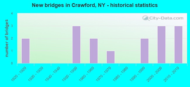
- New bridges - historical statistics
- 21920-1929
- 31950-1959
- 21960-1969
- 11970-1979
- 21990-1999
- 32000-2009
- 32010-2019
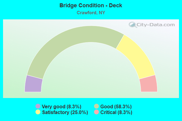
- Bridge Condition - Deck
- 8.3%Very good
- 58.3%Good
- 25.0%Satisfactory
- 8.3%Critical
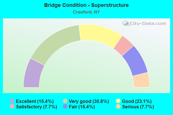
- Bridge Condition - Superstructure
- 15.4%Excellent
- 30.8%Very good
- 23.1%Good
- 7.7%Satisfactory
- 15.4%Fair
- 7.7%Serious
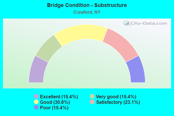
- Bridge Condition - Substructure
- 15.4%Excellent
- 15.4%Very good
- 30.8%Good
- 23.1%Satisfactory
- 15.4%Poor
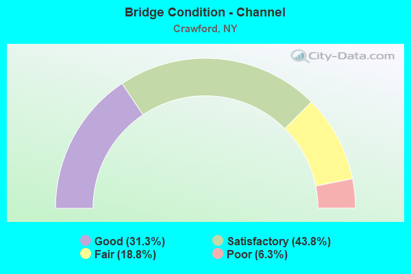
- Bridge Condition - Channel
- 31.3%Good
- 43.8%Satisfactory
- 18.8%Fair
- 6.3%Poor
Find on map >> Show street view
Structure Number: 101448, Location: 0.5 MI W JCT RTS 17K+302 (Lat: 41.543972, Lng: -74.370728), Route carried "on" structure: State highway 17K, Year Built: 1958, Status: Open, Structure Length: 0.76m (2.49ft), Average Daily Traffic: 4,379 (year 2020), Truck Traffic: 14%, Average Future Daily Traffic: 4,399 (year 2040), Design Load: HS 15, Features Intersected: PAKANASINK CREEK
Minimum Vertical Clearance: 30+ m (98+ ft), Kilometerpoint: 5.374, Lanes on structure: 2, Base Highway Network: Yes, Owner: State Highway Agency, Approaching Roadway Width: 11.9m (39.0ft), Material/Design: Concrete continuous, Design/Construction: Culvert, Number Of Spans In Main Unit: 2, Length of Maximum Span: 3.0m (9.8ft), Curb-To-Curb Width: 11.9m (39.0ft), Out-to-Out Width: 12.8m (42.0ft)
Condition: Channel: Fair, Culverts: Satisfactory, Operating Rating: 50.8 metric tons, Method Used To Determine Operating Rating: Load Factor (LF), Inventory Rating: 29.9 metric tons, Method Used To Determine Inventory Rating: Load Factor (LF), Structural Evaluation: Equal to present minimum criteria, Deck Geometry: Somewhat better than minimum adequacy, Waterway Adequacy: Meets minimum limits, Approach Roadway Alignment: Equal to present desirable criteria, Length Of Structure Improvement: 0.76m (2.49ft), Designated Inspection Frequency: Every 24 months, Inspection Date: May 2021, Bridge Improvement Cost: $275,000, Roadway Improvement Cost: $161,000, Total Project Cost: $436,000 ( Estimate for 2021), Wearing Surface/Protective System: Wearing Surface: Bituminous
Find on map >> Show street view
Structure Number: 101449, Location: 1.1 MI E JCT SH17K &SH302 (Lat: 41.538711, Lng: -74.341550), Route carried "on" structure: State highway 17K, Year Built: 1959, Status: Open, Structure Length: 0.76m (2.49ft), Average Daily Traffic: 3,785 (year 2018), Truck Traffic: 11%, Average Future Daily Traffic: 3,802 (year 2040), Design Load: H 20, Features Intersected: DWAAR KILL
Minimum Vertical Clearance: 30+ m (98+ ft), Kilometerpoint: 7.884, Lanes on structure: 2, Base Highway Network: Yes, Owner: State Highway Agency, Approaching Roadway Width: 12.8m (42.0ft), Skew: 2 degrees, Material/Design: Concrete continuous, Design/Construction: Culvert, Number Of Spans In Main Unit: 2, Length of Maximum Span: 3.3m (10.8ft), Curb-To-Curb Width: 11.8m (38.7ft), Out-to-Out Width: 14.2m (46.6ft)
Condition: Channel: Fair, Culverts: Satisfactory, Operating Rating: 54.4 metric tons, Method Used To Determine Operating Rating: Load Factor (LF), Inventory Rating: 32.7 metric tons, Method Used To Determine Inventory Rating: Load Factor (LF), Structural Evaluation: Equal to present minimum criteria, Deck Geometry: Somewhat better than minimum adequacy, Waterway Adequacy: Meets minimum limits, Approach Roadway Alignment: Equal to present desirable criteria, Length Of Structure Improvement: 0.76m (2.49ft), Designated Inspection Frequency: Every 24 months, Inspection Date: June 2021, Bridge Improvement Cost: $304,000, Roadway Improvement Cost: $178,000, Total Project Cost: $482,000 ( Estimate for 2021)
Find on map >> Show street view
Structure Number: 102666, Location: JCT RT 52/SHAWANGUNK KILL (Lat: 41.611469, Lng: -74.304814), Route carried "on" structure: State highway 52, Year Built: 2000, Status: Open, Structure Length: 8.44m (27.69ft), Average Daily Traffic: 7,129 (year 2018), Truck Traffic: 6%, Average Future Daily Traffic: 8,660 (year 2040), Design Load: HS 25 or greater, Features Intersected: SHAWANGUNK KILL
Minimum Vertical Clearance: 30+ m (98+ ft), Kilometerpoint: 0.000, Lanes on structure: 2, Base Highway Network: Yes, Owner: State Highway Agency, Approaching Roadway Width: 9.8m (32.2ft), Material/Design: Steel continuous, Design/Construction: Stringer/Multi-beam, Number Of Spans In Main Unit: 2, Length of Maximum Span: 41.7m (136.8ft), Curb or Sidewalk Widths: Left: 0.0m, Right: 1.5m (4.9ft), Curb-To-Curb Width: 9.7m (31.8ft), Out-to-Out Width: 12.5m (41.0ft)
Condition: Deck: Satisfactory, Superstructure: Very good, Substructure: Good, Channel: Good, Operating Rating: 65.3 metric tons, Method Used To Determine Operating Rating: Allowable Stress (AS), Inventory Rating: 29.0 metric tons, Method Used To Determine Inventory Rating: Allowable Stress (AS), Structural Evaluation: Better than present minimum criteria, Deck Geometry: Meets minimum limits, Waterway Adequacy: Somewhat better than minimum adequacy, Approach Roadway Alignment: Equal to present desirable criteria, Length Of Structure Improvement: 8.44m (27.69ft), Designated Inspection Frequency: Every 24 months, Inspection Date: July 2020, Bridge Improvement Cost: $4,458,000, Roadway Improvement Cost: $2,611,000, Total Project Cost: $7,069,000 ( Estimate for 2021), Deck Structure Type: Concrete Cast-file-Place, Wearing Surface/Protective System: Wearing Surface: Integral Concrete, Deck Protection: Epoxy Coated Reinforcing
Find on map >> Show street view
Structure Number: 102667, Location: 2.2 MI E JCT RTS 52+302 (Lat: 41.594078, Lng: -74.268628), Route carried "on" structure: State highway 52, Year Built: 2017, Status: Open, Structure Length: 1.95m (6.40ft), Average Daily Traffic: 4,716 (year 2016), Truck Traffic: 6%, Average Future Daily Traffic: 5,728 (year 2040), Design Load: HL 93, Features Intersected: DWAAR KILL
Minimum Vertical Clearance: 30+ m (98+ ft), Kilometerpoint: 3.701, Lanes on structure: 2, Owner: State Highway Agency, Approaching Roadway Width: 10.4m (34.1ft), Material/Design: Concrete, Design/Construction: Box Beam or Girders - Multiple, Number Of Spans In Main Unit: 1, Length of Maximum Span: 18.3m (60.0ft), Curb-To-Curb Width: 10.4m (34.1ft), Out-to-Out Width: 11.4m (37.4ft)
Condition: Deck: Good, Superstructure: Excellent, Substructure: Excellent, Channel: Satisfactory, Operating Rating: 51.8 metric tons, Method Used To Determine Operating Rating: Load and Resistance Factor Rating (LRFR) rating reported by rating factor(RF) method using HL-93 loadings, Inventory Rating: 39.9 metric tons, Method Used To Determine Inventory Rating: Load and Resistance Factor Rating (LRFR) rating reported by rating factor(RF) method using HL-93 loadings, Structural Evaluation: Superior to present desirable criteria, Deck Geometry: Somewhat better than minimum adequacy, Waterway Adequacy: Meets minimum limits, Approach Roadway Alignment: Meets minimum limits, Length Of Structure Improvement: 1.95m (6.40ft), Designated Inspection Frequency: Every 24 months, Inspection Date: May 2021, Bridge Improvement Cost: $478,000, Roadway Improvement Cost: $280,000, Total Project Cost: $758,000 ( Estimate for 2021), Deck Structure Type: Concrete Cast-file-Place, Wearing Surface/Protective System: Wearing Surface: Integral Concrete, Deck Protection: Epoxy Coated Reinforcing
Find on map >> Show street view
Structure Number: 222316, Location: 1.3 MI NE THOMPSON RIDGE (Lat: 41.587444, Lng: -74.324936), Route carried "on" structure: Other road , Year Built: 1928, Status: Posted for load, Structure Length: 0.76m (2.49ft), Average Daily Traffic: 199 (year 2017), Truck Traffic: 5%, Average Future Daily Traffic: 279 (year 2037), Features Intersected: PAKANASINK CREEK, Facility Carried by Structure: BRUYN AVENUE
Minimum Vertical Clearance: 30+ m (98+ ft), Kilometerpoint: 0.531, Lanes on structure: 2, Owner: Town or Township Highway Agency, Approaching Roadway Width: 5.8m (19.0ft), Skew: 3 degrees, Material/Design: Steel, Design/Construction: Stringer/Multi-beam, Number Of Spans In Main Unit: 1, Length of Maximum Span: 7.0m (23.0ft), Curb-To-Curb Width: 5.8m (19.0ft), Out-to-Out Width: 6.2m (20.3ft)
Condition: Deck: Critical, Superstructure: Serious, Substructure: Poor, Channel: Poor, Operating Rating: 18.8 metric tons, Method Used To Determine Operating Rating: Load and Resistance Factor Rating (LRFR) rating reported by rating factor(RF) method using HL-93 loadings, Inventory Rating: 14.6 metric tons, Method Used To Determine Inventory Rating: Load and Resistance Factor Rating (LRFR) rating reported by rating factor(RF) method using HL-93 loadings, Structural Evaluation: High priority of corrective action, Deck Geometry: High priority of corrective action, Waterway Adequacy: Equal to present desirable criteria, Approach Roadway Alignment: Meets minimum limits, Bridge Posting: Required (Relationship of Operating Rating to Maximum Legal Load: > 39.9% below), Length Of Structure Improvement: 0.76m (2.49ft), Designated Inspection Frequency: Every 12 months, Inspection Date: April 2021, Bridge Improvement Cost: $447,000, Roadway Improvement Cost: $262,000, Total Project Cost: $709,000 ( Estimate for 2021), Deck Structure Type: Concrete Cast-file-Place, Wearing Surface/Protective System: Wearing Surface: Bituminous
Find on map >> Show street view
Structure Number: 222317, Location: 1.2 MI NORTH OF BULLVILLE (Lat: 41.555767, Lng: -74.365578), Route carried "on" structure: Other road , Year Built: 1991, Status: Open, Structure Length: 1.28m (4.20ft), Average Daily Traffic: 742 (year 2020), Truck Traffic: 7%, Average Future Daily Traffic: 1,039 (year 2040), Design Load: HS 20, Features Intersected: PAKANASINK CREEK, Facility Carried by Structure: BURLINGHAM ROAD
Minimum Vertical Clearance: 30+ m (98+ ft), Kilometerpoint: 3.009, Lanes on structure: 2, Owner: Town or Township Highway Agency, Approaching Roadway Width: 7.3m (24.0ft), Material/Design: Concrete, Design/Construction: Arch - Deck, Number Of Spans In Main Unit: 1, Length of Maximum Span: 12.1m (39.7ft), Curb-To-Curb Width: 8.7m (28.5ft), Out-to-Out Width: 11.4m (37.4ft)
Condition: Superstructure: Very good, Substructure: Very good, Channel: Satisfactory, Operating Rating: 81.3 metric tons, Method Used To Determine Operating Rating: Field evaluation and documented engineering judgment, Inventory Rating: 32.7 metric tons, Method Used To Determine Inventory Rating: Field evaluation and documented engineering judgment, Structural Evaluation: Equal to present desirable criteria, Deck Geometry: Somewhat better than minimum adequacy, Waterway Adequacy: Equal to present desirable criteria, Approach Roadway Alignment: Equal to present desirable criteria, Length Of Structure Improvement: 1.28m (4.20ft), Designated Inspection Frequency: Every 24 months, Inspection Date: March 2020, Bridge Improvement Cost: $502,000, Roadway Improvement Cost: $294,000, Total Project Cost: $797,000 ( Estimate for 2021), Wearing Surface/Protective System: Wearing Surface: Bituminous, Membrane: Other
Find on map >> Show street view
Structure Number: 334434, Location: 2.0 MI NE BLOOMINGBURGH (Lat: 41.572833, Lng: -74.409939), Route carried "on" structure: Other road , Year Built: 2010, Status: Open, Structure Length: 3.72m (12.20ft), Average Daily Traffic: 540 (year 2015), Truck Traffic: 4%, Average Future Daily Traffic: 756 (year 2035), Design Load: HL 93, Features Intersected: SHAWANGUNK KILL, Facility Carried by Structure: PETTICOATE LANE
Minimum Vertical Clearance: 30+ m (98+ ft), Kilometerpoint: 0.000, Lanes on structure: 2, Owner: County Highway Agency, Approaching Roadway Width: 8.5m (27.9ft), Material/Design: Steel, Design/Construction: Truss - Thru, Number Of Spans In Main Unit: 1, Length of Maximum Span: 29.8m (97.8ft), Curb-To-Curb Width: 8.5m (27.9ft), Out-to-Out Width: 8.9m (29.2ft)
Condition: Deck: Good, Superstructure: Very good, Substructure: Good, Channel: Good, Operating Rating: 50.5 metric tons, Method Used To Determine Operating Rating: Load and Resistance Factor Rating (LRFR) rating reported by rating factor(RF) method using HL-93 loadings, Inventory Rating: 38.9 metric tons, Method Used To Determine Inventory Rating: Load and Resistance Factor Rating (LRFR) rating reported by rating factor(RF) method using HL-93 loadings, Structural Evaluation: Better than present minimum criteria, Deck Geometry: Somewhat better than minimum adequacy, Waterway Adequacy: Somewhat better than minimum adequacy, Approach Roadway Alignment: Somewhat better than minimum adequacy, Length Of Structure Improvement: 3.71m (12.17ft), Designated Inspection Frequency: Every 24 months, Critical Feature Inspection Frequency: Every 24 months, Inspection Date: August 2020, Critical Feature Inspection Date: August 2020, Bridge Improvement Cost: $2,618,000, Roadway Improvement Cost: $1,533,000, Total Project Cost: $4,151,000 ( Estimate for 2021), Deck Structure Type: Concrete Cast-file-Place, Wearing Surface/Protective System: Wearing Surface: Bituminous, Membrane: Other, Deck Protection: Epoxy Coated Reinforcing
Find on map >> Show street view
Structure Number: 334436, Location: 2.7 MI NW THOMPSON RIDGE (Lat: 41.586383, Lng: -74.377972), Route carried "on" structure: County highway , Year Built: 1965, Year Reconstructed: 2019, Status: Open, Structure Length: 5.39m (17.68ft), Average Daily Traffic: 837 (year 2020), Truck Traffic: 7%, Average Future Daily Traffic: 1,172 (year 2040), Design Load: HL 93, Features Intersected: SHAWANGUNK KILL, Facility Carried by Structure: COUNTY ROAD 48
Minimum Vertical Clearance: 30+ m (98+ ft), Kilometerpoint: 4.425, Lanes on structure: 2, Owner: County Highway Agency, Approaching Roadway Width: 8.5m (27.9ft), Material/Design: Steel, Design/Construction: Stringer/Multi-beam, Number Of Spans In Main Unit: 2, Length of Maximum Span: 26.2m (86.0ft), Curb-To-Curb Width: 8.5m (27.9ft), Out-to-Out Width: 9.4m (30.8ft)
Condition: Deck: Very good, Superstructure: Excellent, Substructure: Excellent, Channel: Good, Operating Rating: 65.4 metric tons, Method Used To Determine Operating Rating: Load and Resistance Factor Rating (LRFR) rating reported by rating factor(RF) method using HL-93 loadings, Inventory Rating: 50.2 metric tons, Method Used To Determine Inventory Rating: Load and Resistance Factor Rating (LRFR) rating reported by rating factor(RF) method using HL-93 loadings, Structural Evaluation: Superior to present desirable criteria, Deck Geometry: Somewhat better than minimum adequacy, Waterway Adequacy: Somewhat better than minimum adequacy, Approach Roadway Alignment: Equal to present desirable criteria, Length Of Structure Improvement: 5.39m (17.68ft), Designated Inspection Frequency: Every 24 months, Inspection Date: June 2020, Bridge Improvement Cost: $2,165,000, Roadway Improvement Cost: $1,268,000, Total Project Cost: $3,433,000 ( Estimate for 2021), Deck Structure Type: Concrete Cast-file-Place, Wearing Surface/Protective System: Wearing Surface: Integral Concrete, Deck Protection: Epoxy Coated Reinforcing
Find on map >> Show street view
Structure Number: 334437, Location: 1.0 MI W JCT RTS 52 & 302 (Lat: 41.602067, Lng: -74.326500), Route carried "on" structure: Other road , Year Built: 1921, Year Reconstructed: 2010, Status: Open, Structure Length: 2.50m (8.20ft), Average Daily Traffic: 810 (year 2020), Truck Traffic: 4%, Average Future Daily Traffic: 1,134 (year 2040), Design Load: HS 20, Features Intersected: SHAWANGUNK KILL, Facility Carried by Structure: ULSTERVILLE ROAD
Minimum Vertical Clearance: 30+ m (98+ ft), Kilometerpoint: 1.738, Lanes on structure: 2, Owner: County Highway Agency, Approaching Roadway Width: 6.1m (20.0ft), Material/Design: Steel, Design/Construction: Truss - Thru, Number Of Spans In Main Unit: 1, Length of Maximum Span: 24.3m (79.7ft), Curb-To-Curb Width: 7.3m (24.0ft), Out-to-Out Width: 7.6m (24.9ft)
Condition: Deck: Good, Superstructure: Good, Substructure: Good, Channel: Fair, Operating Rating: 47.2 metric tons, Method Used To Determine Operating Rating: Allowable Stress (AS), Inventory Rating: 30.8 metric tons, Method Used To Determine Inventory Rating: Allowable Stress (AS), Structural Evaluation: Better than present minimum criteria, Deck Geometry: Meets minimum limits, Waterway Adequacy: Meets minimum limits, Approach Roadway Alignment: Equal to present desirable criteria, Length Of Structure Improvement: 2.49m (8.17ft), Designated Inspection Frequency: Every 24 months, Critical Feature Inspection Frequency: Every 24 months, Inspection Date: September 2021, Critical Feature Inspection Date: September 2021, Bridge Improvement Cost: $1,976,000, Roadway Improvement Cost: $1,157,000, Total Project Cost: $3,133,000 ( Estimate for 2021), Deck Structure Type: Corrugated Steel, Wearing Surface/Protective System: Wearing Surface: Bituminous
Find on map >> Show street view
Structure Number: 334438, Location: 07 MI N OF PINE BUSH (Lat: 41.618947, Lng: -74.293867), Route carried "on" structure: Other road , Year Built: 1990, Status: Open, Structure Length: 3.84m (12.60ft), Average Daily Traffic: 1,230 (year 2020), Truck Traffic: 6%, Average Future Daily Traffic: 1,722 (year 2040), Design Load: HS 20, Features Intersected: SHAWANGUNK KILL, Facility Carried by Structure: HARDENBURG ROAD
Minimum Vertical Clearance: 30+ m (98+ ft), Kilometerpoint: 0.853, Lanes on structure: 2, Owner: County Highway Agency, Approaching Roadway Width: 7.3m (24.0ft), Skew: 4 degrees, Material/Design: Steel, Design/Construction: Stringer/Multi-beam, Number Of Spans In Main Unit: 1, Length of Maximum Span: 37.4m (122.7ft), Curb-To-Curb Width: 7.3m (24.0ft), Out-to-Out Width: 7.9m (25.9ft)
Condition: Deck: Good, Superstructure: Good, Substructure: Satisfactory, Channel: Good, Operating Rating: 59.0 metric tons, Method Used To Determine Operating Rating: Load and Resistance Factor Rating (LRFR) rating reported by rating factor(RF) method using HL-93 loadings, Inventory Rating: 45.4 metric tons, Method Used To Determine Inventory Rating: Load and Resistance Factor Rating (LRFR) rating reported by rating factor(RF) method using HL-93 loadings, Structural Evaluation: Equal to present minimum criteria, Deck Geometry: Meets minimum limits, Waterway Adequacy: Somewhat better than minimum adequacy, Approach Roadway Alignment: Equal to present desirable criteria, Length Of Structure Improvement: 3.84m (12.60ft), Designated Inspection Frequency: Every 24 months, Inspection Date: September 2021, Bridge Improvement Cost: $2,160,000, Roadway Improvement Cost: $1,265,000, Total Project Cost: $3,425,000 ( Estimate for 2021), Deck Structure Type: Concrete Cast-file-Place, Wearing Surface/Protective System: Wearing Surface: Integral Concrete, Deck Protection: Epoxy Coated Reinforcing
Find on map >> Show street view
Structure Number: 334439, Location: 1.9 MI NE OF PINE BUSH (Lat: 41.628150, Lng: -74.272344), Route carried "on" structure: Other road , Year Built: 2005, Status: Open, Structure Length: 4.33m (14.21ft), Average Daily Traffic: 1,581 (year 2015), Truck Traffic: 6%, Average Future Daily Traffic: 2,213 (year 2035), Design Load: HS 20, Features Intersected: SHAWANGUNK KILL, Facility Carried by Structure: WALLKILL AVE
Minimum Vertical Clearance: 30+ m (98+ ft), Kilometerpoint: 0.000, Lanes on structure: 2, Owner: County Highway Agency, Approaching Roadway Width: 7.3m (24.0ft), Material/Design: Steel, Design/Construction: Truss - Thru, Number Of Spans In Main Unit: 1, Length of Maximum Span: 42.7m (140.1ft), Curb-To-Curb Width: 8.5m (27.9ft), Out-to-Out Width: 9.2m (30.2ft)
Condition: Deck: Good, Superstructure: Very good, Substructure: Good, Channel: Good, Operating Rating: 69.4 metric tons, Method Used To Determine Operating Rating: Load Factor (LF), Inventory Rating: 41.6 metric tons, Method Used To Determine Inventory Rating: Load Factor (LF), Structural Evaluation: Better than present minimum criteria, Deck Geometry: Somewhat better than minimum adequacy, Waterway Adequacy: Equal to present minimum criteria, Approach Roadway Alignment: Equal to present desirable criteria, Length Of Structure Improvement: 4.32m (14.17ft), Designated Inspection Frequency: Every 24 months, Critical Feature Inspection Frequency: Every 24 months, Inspection Date: June 2021, Critical Feature Inspection Date: June 2021, Bridge Improvement Cost: $3,253,000, Roadway Improvement Cost: $1,905,000, Total Project Cost: $5,158,000 ( Estimate for 2021), Deck Structure Type: Concrete Cast-file-Place, Wearing Surface/Protective System: Wearing Surface: Bituminous, Membrane: Other, Deck Protection: Epoxy Coated Reinforcing
Find on map >> Show street view
Structure Number: 33444, Location: 1.3 MI SE THOMPSON RIDGE (Lat: 41.561792, Lng: -74.309028), Route carried "on" structure: County highway , Year Built: 2004, Status: Open, Structure Length: 0.70m (2.30ft), Average Daily Traffic: 1,291 (year 2020), Truck Traffic: 8%, Average Future Daily Traffic: 1,807 (year 2040), Design Load: HS 25 or greater, Features Intersected: DWAAR KILL, Facility Carried by Structure: COLLABAR ROAD
Minimum Vertical Clearance: 30+ m (98+ ft), Kilometerpoint: 3.475, Lanes on structure: 2, Owner: County Highway Agency, Approaching Roadway Width: 10.1m (33.1ft), Material/Design: Concrete, Design/Construction: Culvert, Number Of Spans In Main Unit: 1, Length of Maximum Span: 6.7m (22.0ft), Curb-To-Curb Width: 9.8m (32.2ft), Out-to-Out Width: 10.8m (35.4ft)
Condition: Channel: Satisfactory, Culverts: Satisfactory, Operating Rating: 68.8 metric tons, Method Used To Determine Operating Rating: Load Factor (LF), Inventory Rating: 41.2 metric tons, Method Used To Determine Inventory Rating: Load Factor (LF), Structural Evaluation: Equal to present minimum criteria, Deck Geometry: Somewhat better than minimum adequacy, Waterway Adequacy: Superior to present desirable criteria, Approach Roadway Alignment: Somewhat better than minimum adequacy, Length Of Structure Improvement: 0.70m (2.30ft), Designated Inspection Frequency: Every 24 months, Inspection Date: October 2020, Bridge Improvement Cost: $362,000, Roadway Improvement Cost: $212,000, Total Project Cost: $575,000 ( Estimate for 2021), Wearing Surface/Protective System: Wearing Surface: Bituminous
Find on map >> Show street view
Structure Number: 334442, Location: 0.8 MI W JCT RTS 52+302 (Lat: 41.600783, Lng: -74.322817), Route carried "on" structure: Other road , Year Built: 1951, Status: Open, Structure Length: 1.22m (4.00ft), Average Daily Traffic: 862 (year 2020), Truck Traffic: 2%, Average Future Daily Traffic: 1,207 (year 2040), Design Load: HS 20, Features Intersected: PAKANASINK CREEK, Facility Carried by Structure: ULSTERVILLE ROAD
Minimum Vertical Clearance: 30+ m (98+ ft), Kilometerpoint: 1.416, Lanes on structure: 2, Owner: County Highway Agency, Approaching Roadway Width: 5.5m (18.0ft), Skew: 1 degrees, Material/Design: Steel, Design/Construction: Stringer/Multi-beam, Number Of Spans In Main Unit: 1, Length of Maximum Span: 11.5m (37.7ft), Curb-To-Curb Width: 6.7m (22.0ft), Out-to-Out Width: 7.6m (24.9ft)
Condition: Deck: Satisfactory, Superstructure: Fair, Substructure: Poor, Channel: Satisfactory, Operating Rating: 56.2 metric tons, Method Used To Determine Operating Rating: Load Factor (LF), Inventory Rating: 33.6 metric tons, Method Used To Determine Inventory Rating: Load Factor (LF), Structural Evaluation: Meets minimum limits, Deck Geometry: Meets minimum limits, Waterway Adequacy: Equal to present desirable criteria, Approach Roadway Alignment: Meets minimum limits, Length Of Structure Improvement: 1.21m (3.97ft), Designated Inspection Frequency: Every 24 months, Inspection Date: October 2020, Bridge Improvement Cost: $610,000, Roadway Improvement Cost: $357,000, Total Project Cost: $968,000 ( Estimate for 2021), Deck Structure Type: Concrete Cast-file-Place, Wearing Surface/Protective System: Wearing Surface: Bituminous
Find on map >> Show street view
Structure Number: 334443, Location: 1.9 MI SE THOMPSON RIDGE (Lat: 41.566267, Lng: -74.295614), Route carried "on" structure: County highway , Year Built: 2012, Status: Open, Structure Length: 1.07m (3.51ft), Average Daily Traffic: 1,051 (year 2020), Truck Traffic: 7%, Average Future Daily Traffic: 1,471 (year 2040), Features Intersected: DWAAR KILL, Facility Carried by Structure: COUNTY ROAD 17
Minimum Vertical Clearance: 30+ m (98+ ft), Kilometerpoint: 3.749, Lanes on structure: 2, Owner: County Highway Agency, Approaching Roadway Width: 9.1m (29.9ft), Skew: 4 degrees, Material/Design: Concrete, Design/Construction: Frame, Number Of Spans In Main Unit: 1, Length of Maximum Span: 9.4m (30.8ft), Curb-To-Curb Width: 9.1m (29.9ft), Out-to-Out Width: 10.7m (35.1ft)
Condition: Deck: Good, Superstructure: Good, Substructure: Very good, Channel: Satisfactory, Operating Rating: 83.5 metric tons, Method Used To Determine Operating Rating: Load Factor (LF), Inventory Rating: 49.9 metric tons, Method Used To Determine Inventory Rating: Load Factor (LF), Structural Evaluation: Better than present minimum criteria, Deck Geometry: Somewhat better than minimum adequacy, Waterway Adequacy: Superior to present desirable criteria, Approach Roadway Alignment: Equal to present minimum criteria, Length Of Structure Improvement: 1.06m (3.48ft), Designated Inspection Frequency: Every 24 months, Inspection Date: October 2020, Bridge Improvement Cost: $696,000, Roadway Improvement Cost: $408,000, Total Project Cost: $1,104,000 ( Estimate for 2021), Wearing Surface/Protective System: Wearing Surface: Bituminous
Find on map >> Show street view
Structure Number: 334444, Location: 2.3 MI SE PINE BUSH (Lat: 41.587472, Lng: -74.268283), Route carried "on" structure: County highway , Year Built: 1967, Status: Open, Structure Length: 1.16m (3.81ft), Average Daily Traffic: 1,486 (year 2020), Truck Traffic: 5%, Average Future Daily Traffic: 1,549 (year 2040), Design Load: HS 20, Features Intersected: DWAAR KILL, Facility Carried by Structure: HILL ROAD
Minimum Vertical Clearance: 30+ m (98+ ft), Kilometerpoint: 1.915, Lanes on structure: 2, Owner: County Highway Agency, Approaching Roadway Width: 7.3m (24.0ft), Material/Design: Steel, Design/Construction: Stringer/Multi-beam, Number Of Spans In Main Unit: 1, Length of Maximum Span: 10.9m (35.8ft), Curb-To-Curb Width: 10.4m (34.1ft), Out-to-Out Width: 11.3m (37.1ft)
Condition: Deck: Satisfactory, Superstructure: Satisfactory, Substructure: Satisfactory, Channel: Satisfactory, Operating Rating: 48.9 metric tons, Method Used To Determine Operating Rating: Load and Resistance Factor Rating (LRFR) rating reported by rating factor(RF) method using HL-93 loadings, Inventory Rating: 37.6 metric tons, Method Used To Determine Inventory Rating: Load and Resistance Factor Rating (LRFR) rating reported by rating factor(RF) method using HL-93 loadings, Structural Evaluation: Equal to present minimum criteria, Deck Geometry: Equal to present minimum criteria, Waterway Adequacy: Somewhat better than minimum adequacy, Approach Roadway Alignment: Equal to present desirable criteria, Length Of Structure Improvement: 1.15m (3.77ft), Designated Inspection Frequency: Every 24 months, Inspection Date: June 2020, Bridge Improvement Cost: $1,062,000, Roadway Improvement Cost: $622,000, Total Project Cost: $1,684,000 ( Estimate for 2021), Deck Structure Type: Concrete Cast-file-Place, Wearing Surface/Protective System: Wearing Surface: Bituminous
Find on map >> Show street view
Structure Number: 336017, Location: 2.2 MI NW THOMPSON RIDGE (Lat: 41.598619, Lng: -74.349353), Route carried "on" structure: Other road , Year Built: 1975, Year Reconstructed: 2017, Status: Posted for load, Structure Length: 3.11m (10.20ft), Average Daily Traffic: 468 (year 2020), Truck Traffic: 3%, Average Future Daily Traffic: 655 (year 2040), Features Intersected: SHAWANGUNK KILL, Facility Carried by Structure: CRAWFORD STREET
Minimum Vertical Clearance: 30+ m (98+ ft), Kilometerpoint: 2.912, Lanes on structure: 1, Owner: County Highway Agency, Approaching Roadway Width: 5.2m (17.1ft), Material/Design: Steel, Design/Construction: Truss - Thru, Number Of Spans In Main Unit: 1, Length of Maximum Span: 30.4m (99.7ft), Curb-To-Curb Width: 3.4m (11.2ft), Out-to-Out Width: 4.3m (14.1ft)
Condition: Deck: Good, Superstructure: Fair, Substructure: Satisfactory, Channel: Satisfactory, Operating Rating: 9.1 metric tons, Method Used To Determine Operating Rating: Field evaluation and documented engineering judgment, Inventory Rating: 9.1 metric tons, Method Used To Determine Inventory Rating: Field evaluation and documented engineering judgment, Structural Evaluation: High priority of corrective action, Deck Geometry: High priority of replacement, Waterway Adequacy: Meets minimum limits, Approach Roadway Alignment: Meets minimum limits, Bridge Posting: Required (Relationship of Operating Rating to Maximum Legal Load: > 39.9% below), Length Of Structure Improvement: 3.10m (10.17ft), Designated Inspection Frequency: Every 12 months, Critical Feature Inspection Frequency: Every 12 months, Inspection Date: September 2021, Critical Feature Inspection Date: September 2021, Bridge Improvement Cost: $1,115,000, Roadway Improvement Cost: $653,000, Total Project Cost: $1,767,000 ( Estimate for 2021), Deck Structure Type: Open Grating, Wearing Surface/Protective System: Wearing Surface: Other