Bridge Statistics for Crete, Illinois (IL)
Condition, Traffic, Stress, Structural Evaluation, Project Costs
- National Bridge Inventory (NBI) Statistics
- 14Number of bridges
- 69ft / 21.2mTotal length
- $2,016,000Total costs
- 71,675Total average daily traffic
- 8,112Total average daily truck traffic
- National Bridge Inventory (NBI) Registered Bridges for Crete
- No street view available for this location
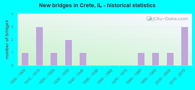
- New bridges - historical statistics
- 11900-1909
- 31910-1919
- 11920-1929
- 21930-1939
- 11940-1949
- 11980-1989
- 11990-1999
- 12000-2009
- 32010-2019
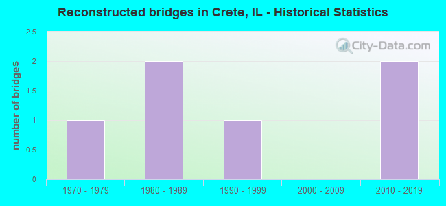
- Reconstructed bridges - Historical Statistics
- 11970-1979
- 21980-1989
- 11990-1999
- 02000-2009
- 22010-2019
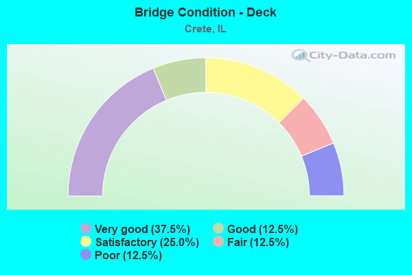
- Bridge Condition - Deck
- 37.5%Very good
- 12.5%Good
- 25.0%Satisfactory
- 12.5%Fair
- 12.5%Poor
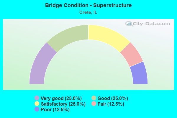
- Bridge Condition - Superstructure
- 25.0%Very good
- 25.0%Good
- 25.0%Satisfactory
- 12.5%Fair
- 12.5%Poor
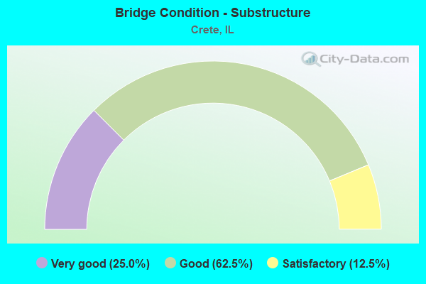
- Bridge Condition - Substructure
- 25.0%Very good
- 62.5%Good
- 12.5%Satisfactory
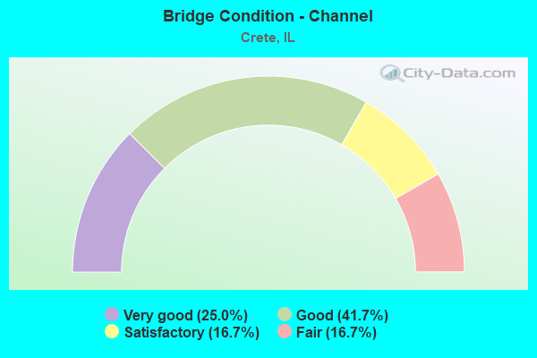
- Bridge Condition - Channel
- 25.0%Very good
- 41.7%Good
- 16.7%Satisfactory
- 16.7%Fair
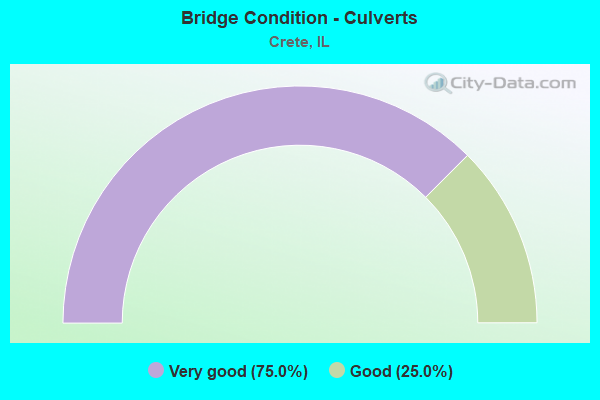
- Bridge Condition - Culverts
- 75.0%Very good
- 25.0%Good
Find on map >> Show street view
Structure Number: 990076, Location: 0.8 M S OF COOK CO (Lat: 41.458536, Lng: -87.633731), Route carried "on" structure: State highway 1, Year Built: 1928, Year Reconstructed: 1981, Status: Open, Structure Length: 0.98m (3.22ft), Average Daily Traffic: 6,850 (year 2021), Truck Traffic: 13%, Average Future Daily Traffic: 17,701 (year 2032), Features Intersected: DEER CREEK
Minimum Vertical Clearance: 30+ m (98+ ft), Kilometerpoint: 491.641, Lanes on structure: 3, Base Highway Network: Yes, Owner: State Highway Agency, Approaching Roadway Width: 11.0m (36.1ft), Material/Design: Concrete, Design/Construction: Slab, Number Of Spans In Main Unit: 1, Length of Maximum Span: 9.4m (30.8ft), Curb or Sidewalk Widths: Left: 1.8m (5.9ft), Right: 1.8m (5.9ft), Curb-To-Curb Width: 11.0m (36.1ft), Out-to-Out Width: 15.3m (50.2ft)
Condition: Deck: Poor, Superstructure: Poor, Substructure: Satisfactory, Channel: Fair, Operating Rating: 41.1 metric tons, Method Used To Determine Operating Rating: Load Factor (LF) rating reported by rating factor (RF) method using MS18 loading, Inventory Rating: 24.6 metric tons, Method Used To Determine Inventory Rating: Load Factor (LF) rating reported by rating factor (RF) method using MS18 loading, Structural Evaluation: Meets minimum limits, Deck Geometry: High priority of replacement, Waterway Adequacy: Equal to present minimum criteria, Approach Roadway Alignment: Equal to present desirable criteria, Length Of Structure Improvement: 1.65m (5.41ft), Designated Inspection Frequency: Every 12 months, Other Special Inspection Frequency: Every 24 months, Inspection Date: May 2021, Other Special Inspection Date: May 2020, Bridge Improvement Cost: $248,000, Roadway Improvement Cost: $25,000, Total Project Cost: $372,000, Deck Structure Type: Concrete Cast-file-Place, Wearing Surface/Protective System: Wearing Surface: Integral Concrete
Find on map >> Show street view
Structure Number: 990147, Location: 9.2 M S OF US 30 (Lat: 41.392469, Lng: -87.626767), Route carried "on" structure: State highway 1, Year Built: 1949, Year Reconstructed: 2010, Status: Open, Structure Length: 3.69m (12.11ft), Average Daily Traffic: 8,400 (year 2021), Truck Traffic: 17%, Average Future Daily Traffic: 5,967 (year 2032), Design Load: HS 20, Features Intersected: PLUM CREEK, Facility Carried by Structure: IL 394 NB
Minimum Vertical Clearance: 30+ m (98+ ft), Kilometerpoint: 484.094, Lanes on structure: 2, Base Highway Network: Yes, Owner: State Highway Agency, Approaching Roadway Width: 11.6m (38.1ft), Material/Design: Steel continuous, Design/Construction: Stringer/Multi-beam, Number Of Spans In Main Unit: 3, Length of Maximum Span: 14.6m (47.9ft), Curb-To-Curb Width: 10.7m (35.1ft), Out-to-Out Width: 11.6m (38.1ft)
Condition: Deck: Very good, Superstructure: Very good, Substructure: Very good, Channel: Good, Operating Rating: 89.1 metric tons, Method Used To Determine Operating Rating: Load Factor (LF) rating reported by rating factor (RF) method using MS18 loading, Inventory Rating: 68.7 metric tons, Method Used To Determine Inventory Rating: Load Factor (LF) rating reported by rating factor (RF) method using MS18 loading, Structural Evaluation: Equal to present desirable criteria, Deck Geometry: Somewhat better than minimum adequacy, Waterway Adequacy: Equal to present desirable criteria, Approach Roadway Alignment: Equal to present desirable criteria, Length Of Structure Improvement: 4.69m (15.39ft), Designated Inspection Frequency: Every 48 months, Inspection Date: September 2021, Bridge Improvement Cost: $573,000, Roadway Improvement Cost: $57,000, Total Project Cost: $860,000, Deck Structure Type: Concrete Cast-file-Place, Wearing Surface/Protective System: Deck Protection: Epoxy Coated Reinforcing
Find on map >> Show street view
Structure Number: 990183, Location: 9.2 M S OF US 30 (Lat: 41.392619, Lng: -87.626750), Route carried "on" structure: State highway 1, Year Built: 1932, Year Reconstructed: 2010, Status: Open, Structure Length: 3.90m (12.80ft), Average Daily Traffic: 8,400 (year 2021), Truck Traffic: 17%, Average Future Daily Traffic: 5,967 (year 2032), Design Load: HS 20, Features Intersected: PLUM CREEK, Facility Carried by Structure: IL 394 SB
Minimum Vertical Clearance: 30+ m (98+ ft), Kilometerpoint: 484.110, Lanes on structure: 2, Base Highway Network: Yes, Owner: State Highway Agency, Approaching Roadway Width: 12.2m (40.0ft), Material/Design: Steel continuous, Design/Construction: Stringer/Multi-beam, Number Of Spans In Main Unit: 3, Length of Maximum Span: 14.6m (47.9ft), Curb-To-Curb Width: 12.3m (40.4ft), Out-to-Out Width: 13.3m (43.6ft)
Condition: Deck: Very good, Superstructure: Good, Substructure: Good, Channel: Good, Operating Rating: 77.8 metric tons, Method Used To Determine Operating Rating: Load Factor (LF) rating reported by rating factor (RF) method using MS18 loading, Inventory Rating: 46.7 metric tons, Method Used To Determine Inventory Rating: Load Factor (LF) rating reported by rating factor (RF) method using MS18 loading, Structural Evaluation: Better than present minimum criteria, Deck Geometry: Better than present minimum criteria, Waterway Adequacy: Equal to present desirable criteria, Approach Roadway Alignment: Equal to present desirable criteria, Length Of Structure Improvement: 3.81m (12.50ft), Designated Inspection Frequency: Every 48 months, Inspection Date: September 2021, Bridge Improvement Cost: $401,000, Roadway Improvement Cost: $40,000, Total Project Cost: $602,000, Deck Structure Type: Concrete Cast-file-Place, Wearing Surface/Protective System: Deck Protection: Epoxy Coated Reinforcing
Find on map >> Show street view
Structure Number: 993085, Location: BWTN IL 1 & IL 394 (Lat: 41.447353, Lng: -87.608597), Route carried "on" structure: Other road , Year Built: 2014, Status: Open, Structure Length: 0.78m (2.56ft), Average Daily Traffic: 6,450 (year 2019), Truck Traffic: 5%, Average Future Daily Traffic: 8,900 (year 2032), Design Load: HS 20, Features Intersected: DEER CREEK TRIBUTARY, Facility Carried by Structure: EXCHANGE ST. (CH 4
Minimum Vertical Clearance: 30+ m (98+ ft), Kilometerpoint: 7.805, Lanes on structure: 2, Base Highway Network: Yes, Owner: County Highway Agency, Approaching Roadway Width: 14.0m (45.9ft), Material/Design: Concrete continuous, Design/Construction: Culvert, Number Of Spans In Main Unit: 2, Length of Maximum Span: 3.8m (12.5ft)
Condition: Channel: Very good, Culverts: Very good, Operating Rating: 42.1 metric tons, Method Used To Determine Operating Rating: Assigned ratings based on Load and Resistance Factor Design (LRFD) reported by rating factor (RF) using HL93 loadings, Inventory Rating: 32.4 metric tons, Method Used To Determine Inventory Rating: Assigned ratings based on Load and Resistance Factor Design (LRFD) reported by rating factor (RF) using HL93 loadings, Structural Evaluation: Equal to present desirable criteria, Waterway Adequacy: Superior to present desirable criteria, Approach Roadway Alignment: Equal to present minimum criteria, Designated Inspection Frequency: Every 48 months, Inspection Date: January 2021
Find on map >> Show street view
Structure Number: 993377, Location: 0.06 MI W IL-1 (Lat: 41.391622, Lng: -87.628156), Route carried "on" structure: County highway , Year Built: 2019, Status: Open, Structure Length: 1.05m (3.44ft), Average Daily Traffic: 3,450 (year 2019), Truck Traffic: 10%, Average Future Daily Traffic: 5,762 (year 2038), Design Load: HS 20, Features Intersected: PLUM CREEK, Facility Carried by Structure: GOODENOW RD
Minimum Vertical Clearance: 30+ m (98+ ft), Kilometerpoint: 10.911, Lanes on structure: 2, Owner: County Highway Agency, Approaching Roadway Width: 13.4m (44.0ft), Material/Design: Concrete continuous, Design/Construction: Culvert, Number Of Spans In Main Unit: 3, Length of Maximum Span: 3.6m (11.8ft)
Condition: Channel: Very good, Culverts: Very good, Operating Rating: 88.8 metric tons, Method Used To Determine Operating Rating: Load Factor (LF) rating reported by rating factor (RF) method using MS18 loading, Inventory Rating: 88.8 metric tons, Method Used To Determine Inventory Rating: Load Factor (LF) rating reported by rating factor (RF) method using MS18 loading, Structural Evaluation: Equal to present desirable criteria, Waterway Adequacy: Superior to present desirable criteria, Approach Roadway Alignment: Equal to present desirable criteria, Designated Inspection Frequency: Every 48 months, Inspection Date: October 2021
Find on map >> Show street view
Structure Number: 993385, Location: .5M E OF IL394 (Lat: 41.437603, Lng: -87.565811), Route carried "on" structure: Other road , Year Built: 2003, Status: Open, Structure Length: 3.07m (10.07ft), Average Daily Traffic: 16,200 (year 2019), Truck Traffic: 9%, Average Future Daily Traffic: 17,567 (year 2032), Design Load: HS 20, Features Intersected: PLUM CREEK, Facility Carried by Structure: EXCHANGE ST.
Minimum Vertical Clearance: 30+ m (98+ ft), Kilometerpoint: 11.748, Lanes on structure: 2, Base Highway Network: Yes, Owner: County Highway Agency, Approaching Roadway Width: 12.2m (40.0ft), Material/Design: Concrete continuous, Design/Construction: Slab, Number Of Spans In Main Unit: 3, Length of Maximum Span: 10.7m (35.1ft), Curb-To-Curb Width: 12.2m (40.0ft), Out-to-Out Width: 12.2m (40.0ft)
Condition: Deck: Very good, Superstructure: Very good, Substructure: Very good, Channel: Very good, Operating Rating: 44.1 metric tons, Method Used To Determine Operating Rating: Assigned rating based on Load Factor Design (LFD) reported by rating factor (RF) using MS18 loading, Inventory Rating: 32.4 metric tons, Method Used To Determine Inventory Rating: Assigned rating based on Load Factor Design (LFD) reported by rating factor (RF) using MS18 loading, Structural Evaluation: Equal to present desirable criteria, Deck Geometry: Somewhat better than minimum adequacy, Waterway Adequacy: Equal to present desirable criteria, Approach Roadway Alignment: Equal to present desirable criteria, Designated Inspection Frequency: Every 48 months, Inspection Date: January 2021, Deck Structure Type: Concrete Cast-file-Place, Wearing Surface/Protective System: Deck Protection: Epoxy Coated Reinforcing
Find on map >> Show street view
Structure Number: 993386, Location: 0.14 MI W OF IL-1 (Lat: 41.391608, Lng: -87.629500), Route carried "on" structure: County highway , Year Built: 2019, Status: Open, Structure Length: 0.63m (2.07ft), Average Daily Traffic: 3,450 (year 2019), Truck Traffic: 10%, Average Future Daily Traffic: 5,762 (year 2038), Design Load: HS 20, Features Intersected: BR. OF PLUM CREEK, Facility Carried by Structure: GOODENOW ROAD
Minimum Vertical Clearance: 30+ m (98+ ft), Kilometerpoint: 10.798, Lanes on structure: 2, Owner: County Highway Agency, Approaching Roadway Width: 13.4m (44.0ft), Material/Design: Concrete continuous, Design/Construction: Culvert, Number Of Spans In Main Unit: 2, Length of Maximum Span: 3.3m (10.8ft)
Condition: Channel: Fair, Culverts: Very good, Operating Rating: 55.1 metric tons, Method Used To Determine Operating Rating: Load Factor (LF) rating reported by rating factor (RF) method using MS18 loading, Inventory Rating: 33.0 metric tons, Method Used To Determine Inventory Rating: Load Factor (LF) rating reported by rating factor (RF) method using MS18 loading, Structural Evaluation: Equal to present desirable criteria, Waterway Adequacy: Superior to present desirable criteria, Approach Roadway Alignment: Equal to present desirable criteria, Designated Inspection Frequency: Every 48 months, Inspection Date: October 2021
Find on map >> Show street view
Structure Number: 994701, Location: 0.5 MI S IL 394 (Lat: 41.407997, Lng: -87.598408), Route carried "on" structure: County highway , Year Built: 1982, Status: Open, Structure Length: 1.46m (4.79ft), Average Daily Traffic: 1,150 (year 2019), Truck Traffic: 17%, Average Future Daily Traffic: 1,274 (year 2032), Design Load: HS 20, Features Intersected: PLUM CREEK, Facility Carried by Structure: BEMES RD
Minimum Vertical Clearance: 30+ m (98+ ft), Kilometerpoint: 0.853, Lanes on structure: 2, Owner: Town or Township Highway Agency, Approaching Roadway Width: 8.8m (28.9ft), Skew: 3 degrees, Material/Design: Prestressed concrete, Design/Construction: Box Beam or Girders - Multiple, Number Of Spans In Main Unit: 1, Length of Maximum Span: 14.6m (47.9ft), Curb-To-Curb Width: 10.2m (33.5ft), Out-to-Out Width: 10.2m (33.5ft)
Condition: Deck: Fair, Superstructure: Fair, Substructure: Good, Channel: Satisfactory, Operating Rating: 44.4 metric tons, Method Used To Determine Operating Rating: Assigned rating based on Load Factor Design (LFD) reported by rating factor (RF) using MS18 loading, Inventory Rating: 32.4 metric tons, Method Used To Determine Inventory Rating: Assigned rating based on Load Factor Design (LFD) reported by rating factor (RF) using MS18 loading, Structural Evaluation: Somewhat better than minimum adequacy, Deck Geometry: Somewhat better than minimum adequacy, Waterway Adequacy: Equal to present desirable criteria, Approach Roadway Alignment: Equal to present minimum criteria, Designated Inspection Frequency: Every 24 months, Inspection Date: March 2021, Deck Structure Type: Concrete Precast Panels, Wearing Surface/Protective System: Wearing Surface: Bituminous
Find on map >> Show street view
Structure Number: 994704, Location: .2 E OF ILL 394 (Lat: 41.435736, Lng: -87.571750), Route carried "on" structure: County highway , Year Built: 1919, Year Reconstructed: 1987, Status: Open, Structure Length: 2.16m (7.09ft), Average Daily Traffic: 3,100 (year 2019), Truck Traffic: 7%, Average Future Daily Traffic: 2,481 (year 2032), Design Load: HS 20, Features Intersected: PLUM CR, Facility Carried by Structure: BURVILLE RD
Minimum Vertical Clearance: 30+ m (98+ ft), Kilometerpoint: 0.418, Lanes on structure: 2, Owner: Town or Township Highway Agency, Approaching Roadway Width: 7.3m (24.0ft), Skew: 1 degrees, Material/Design: Prestressed concrete, Design/Construction: Box Beam or Girders - Multiple, Number Of Spans In Main Unit: 1, Length of Maximum Span: 21.0m (68.9ft), Curb-To-Curb Width: 10.1m (33.1ft), Out-to-Out Width: 10.1m (33.1ft)
Condition: Deck: Satisfactory, Superstructure: Satisfactory, Substructure: Good, Channel: Good, Operating Rating: 57.7 metric tons, Method Used To Determine Operating Rating: Load Factor (LF) rating reported by rating factor (RF) method using MS18 loading, Inventory Rating: 34.3 metric tons, Method Used To Determine Inventory Rating: Load Factor (LF) rating reported by rating factor (RF) method using MS18 loading, Structural Evaluation: Equal to present minimum criteria, Deck Geometry: Meets minimum limits, Waterway Adequacy: Better than present minimum criteria, Approach Roadway Alignment: Equal to present desirable criteria, Designated Inspection Frequency: Every 24 months, Inspection Date: March 2021, Deck Structure Type: Concrete Precast Panels, Wearing Surface/Protective System: Wearing Surface: Bituminous
Find on map >> Show street view
Structure Number: 995003, Location: 1.8 MI W.IL 1 (Lat: 41.369550, Lng: -87.655217), Route carried "on" structure: Other road , Year Built: 1917, Year Reconstructed: 1985, Status: Open, Structure Length: 1.33m (4.36ft), Average Daily Traffic: 425 (year 2019), Truck Traffic: 6%, Average Future Daily Traffic: 369 (year 2032), Design Load: HS 20, Features Intersected: PLUM CREEK, Facility Carried by Structure: EAGLE LAKE ROAD
Minimum Vertical Clearance: 30+ m (98+ ft), Kilometerpoint: 10.831, Lanes on structure: 2, Owner: Town or Township Highway Agency, Approaching Roadway Width: 9.8m (32.2ft), Skew: 3 degrees, Material/Design: Prestressed concrete, Design/Construction: Box Beam or Girders - Multiple, Number Of Spans In Main Unit: 1, Length of Maximum Span: 12.4m (40.7ft), Curb-To-Curb Width: 9.1m (29.9ft), Out-to-Out Width: 9.1m (29.9ft)
Condition: Deck: Satisfactory, Superstructure: Satisfactory, Substructure: Good, Channel: Good, Operating Rating: 61.6 metric tons, Method Used To Determine Operating Rating: Load Factor (LF) rating reported by rating factor (RF) method using MS18 loading, Inventory Rating: 36.6 metric tons, Method Used To Determine Inventory Rating: Load Factor (LF) rating reported by rating factor (RF) method using MS18 loading, Structural Evaluation: Equal to present minimum criteria, Deck Geometry: Equal to present minimum criteria, Waterway Adequacy: Equal to present desirable criteria, Approach Roadway Alignment: Equal to present desirable criteria, Designated Inspection Frequency: Every 24 months, Inspection Date: April 2021, Deck Structure Type: Concrete Precast Panels, Wearing Surface/Protective System: Wearing Surface: Bituminous
Find on map >> Show street view
Structure Number: 995004, Location: 0.4 M N.EAGLE LK RD (Lat: 41.376375, Lng: -87.650442), Route carried "on" structure: County highway , Year Built: 1991, Status: Open, Structure Length: 0.79m (2.59ft), Average Daily Traffic: 1,250 (year 2019), Truck Traffic: 9%, Average Future Daily Traffic: 369 (year 2032), Design Load: HS 20, Features Intersected: STREAM, Facility Carried by Structure: ASHLAND AVE.
Minimum Vertical Clearance: 30+ m (98+ ft), Kilometerpoint: 2.076, Lanes on structure: 2, Owner: Town or Township Highway Agency, Approaching Roadway Width: 6.1m (20.0ft), Material/Design: Concrete continuous, Design/Construction: Culvert, Number Of Spans In Main Unit: 2, Length of Maximum Span: 3.9m (12.8ft)
Condition: Channel: Good, Culverts: Good, Operating Rating: 44.4 metric tons, Method Used To Determine Operating Rating: Assigned rating based on Load Factor Design (LFD) reported by rating factor (RF) using MS18 loading, Inventory Rating: 32.4 metric tons, Method Used To Determine Inventory Rating: Assigned rating based on Load Factor Design (LFD) reported by rating factor (RF) using MS18 loading, Structural Evaluation: Better than present minimum criteria, Waterway Adequacy: Equal to present desirable criteria, Approach Roadway Alignment: Equal to present desirable criteria, Designated Inspection Frequency: Every 48 months, Inspection Date: April 2021
Find on map >> Show street view
Structure Number: 99625, Location: 2 MI W RTE 394 (Lat: 41.460183, Lng: -87.609142), Route carried "on" structure: Other road , Year Built: 1932, Year Reconstructed: 2003, Status: Open, Structure Length: 1.39m (4.56ft), Average Daily Traffic: 2,250 (year 2019), Truck Traffic: 5%, Average Future Daily Traffic: 1,676 (year 2032), Design Load: HS 20, Features Intersected: DEER CREEK, Facility Carried by Structure: RICHTON RD
Minimum Vertical Clearance: 30+ m (98+ ft), Kilometerpoint: 2.173, Lanes on structure: 2, Owner: City or Municipal Highway Agency, Approaching Roadway Width: 9.1m (29.9ft), Material/Design: Prestressed concrete, Design/Construction: Stringer/Multi-beam, Number Of Spans In Main Unit: 1, Length of Maximum Span: 12.6m (41.3ft), Curb-To-Curb Width: 9.1m (29.9ft), Out-to-Out Width: 10.1m (33.1ft)
Condition: Deck: Good, Superstructure: Good, Substructure: Good, Channel: Satisfactory, Operating Rating: 71.3 metric tons, Method Used To Determine Operating Rating: Load Factor (LF) rating reported by rating factor (RF) method using MS18 loading, Inventory Rating: 42.8 metric tons, Method Used To Determine Inventory Rating: Load Factor (LF) rating reported by rating factor (RF) method using MS18 loading, Structural Evaluation: Better than present minimum criteria, Deck Geometry: Meets minimum limits, Waterway Adequacy: Equal to present desirable criteria, Approach Roadway Alignment: Superior to present desirable criteria, Length Of Structure Improvement: 1.98m (6.50ft), Designated Inspection Frequency: Every 48 months, Inspection Date: Febuary 2018, Bridge Improvement Cost: $121,000, Roadway Improvement Cost: $12,000, Total Project Cost: $182,000, Deck Structure Type: Concrete Precast Panels, Wearing Surface/Protective System: Wearing Surface: Bituminous, Membrane: Built-up, Deck Protection: Other
Find on map >> Show street view
Structure Number: 990229, Location: 0.7 MI S OF COOK CO (Lat: 41.459575, Lng: -87.634244), Route carried "under" structure: State highway 1, Year Built: 1900, Structure Length: 0. m, Average Daily Traffic: 6,850 (year 2021), Truck Traffic: 13%, Features Intersected: IL RT 1, Facility Carried by Structure: CE & I RR
Minimum Vertical Clearance: 4.27m (14.01ft), Kilometerpoint: 491.770, Lanes under structure: 2, Material/Design: Steel, Design/Construction: Girder and Floorbeam System, Length of Maximum Span: 8.8m (28.9ft)
Find on map >> Show street view
Structure Number: 993076, Location: .5 M W ILL-1 (Lat: 41.391536, Lng: -87.636978), Route carried "under" structure: County highway , Year Built: 1918, Structure Length: 0. m, Average Daily Traffic: 3,450 (year 2019), Truck Traffic: 10%, Features Intersected: GOODENOW RD, Facility Carried by Structure: C&EI RR
Minimum Vertical Clearance: 3.66m (12.01ft), Kilometerpoint: 10.171, Lanes under structure: 2, Material/Design: Steel, Length of Maximum Span: 6.4m (21.0ft)