Bridge Statistics for Crothersville, Indiana (IN)
Condition, Traffic, Stress, Structural Evaluation, Project Costs
- National Bridge Inventory (NBI) Statistics
- 30Number of bridges
- 259ft / 78.9mTotal length
- $700,000Total costs
- 194,549Total average daily traffic
- 19,345Total average daily truck traffic
- National Bridge Inventory (NBI) Registered Bridges for Crothersville
- No street view available for this location
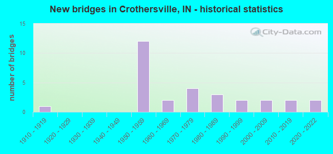
- New bridges - historical statistics
- 11910-1919
- 121950-1959
- 21960-1969
- 41970-1979
- 31980-1989
- 21990-1999
- 22000-2009
- 22010-2019
- 22020-2022

- Reconstructed bridges - Historical Statistics
- 11970-1979
- 61980-1989
- 11990-1999
- 02000-2009
- 12010-2019


- Bridge Condition - Deck
- 21.1%Excellent
- 31.6%Good
- 36.8%Satisfactory
- 10.5%Fair

- Bridge Condition - Superstructure
- 21.1%Excellent
- 47.4%Good
- 21.1%Satisfactory
- 5.3%Fair
- 5.3%Critical

- Bridge Condition - Substructure
- 21.1%Excellent
- 47.4%Good
- 26.3%Satisfactory
- 5.3%Fair

- Bridge Condition - Channel
- 10.5%Excellent
- 15.8%Very good
- 5.3%Good
- 42.1%Satisfactory
- 15.8%Fair
- 10.5%Poor

- Bridge Condition - Culverts
- 20.0%Good
- 40.0%Satisfactory
- 40.0%Fair
Find on map >> Show street view
Structure Number: 91, Location: 02.93 S SR 250 (Lat: 38.805119, Lng: -85.840061), Route carried "on" structure: US 31, Year Built: 1984, Year Reconstructed: 2019, Status: Open, Structure Length: 3.17m (10.40ft), Average Daily Traffic: 3,430 (year 2018), Truck Traffic: 8%, Average Future Daily Traffic: 3,430 (year 2038), Design Load: HS 20, Features Intersected: BLAU DITCH
Minimum Vertical Clearance: 30+ m (98+ ft), Kilometerpoint: 4.394, Lanes on structure: 2, Owner: State Highway Agency, Approaching Roadway Width: 13.4m (44.0ft), Skew: 4 degrees, Material/Design: Concrete continuous, Design/Construction: Slab, Number Of Spans In Main Unit: 3, Length of Maximum Span: 12.8m (42.0ft), Curb-To-Curb Width: 13.3m (43.6ft), Out-to-Out Width: 14.2m (46.6ft)
Condition: Deck: Good, Superstructure: Good, Substructure: Good, Channel: Very good, Operating Rating: 41.8 metric tons, Method Used To Determine Operating Rating: Load and Resistance Factor Rating (LRFR) rating reported by rating factor(RF) method using HL-93 loadings, Inventory Rating: 32.4 metric tons, Method Used To Determine Inventory Rating: Load and Resistance Factor Rating (LRFR) rating reported by rating factor(RF) method using HL-93 loadings, Structural Evaluation: Better than present minimum criteria, Deck Geometry: Equal to present minimum criteria, Waterway Adequacy: Superior to present desirable criteria, Approach Roadway Alignment: Equal to present desirable criteria, Designated Inspection Frequency: Every 24 months, Inspection Date: June 2020, Deck Structure Type: Concrete Cast-file-Place, Wearing Surface/Protective System: Wearing Surface: Latex Concrete, Deck Protection: Epoxy Coated Reinforcing
Find on map >> Show street view
Structure Number: 9111, Location: 02.02 S SR 250 (Lat: 38.817919, Lng: -85.837419), Route carried "on" structure: US 31, Year Built: 2019, Status: Open, Structure Length: 2.91m (9.55ft), Average Daily Traffic: 3,430 (year 2019), Truck Traffic: 8%, Average Future Daily Traffic: 3,430 (year 2039), Design Load: HL 93, Features Intersected: GRASSY CREEK
Minimum Vertical Clearance: 30+ m (98+ ft), Kilometerpoint: 5.858, Lanes on structure: 2, Owner: State Highway Agency, Approaching Roadway Width: 11.6m (38.1ft), Material/Design: Prestressed concrete, Design/Construction: Tee Beam, Number Of Spans In Main Unit: 1, Length of Maximum Span: 28.5m (93.5ft), Curb-To-Curb Width: 11.4m (37.4ft), Out-to-Out Width: 12.3m (40.4ft)
Condition: Deck: Excellent, Superstructure: Excellent, Substructure: Excellent, Channel: Excellent, Operating Rating: 63.8 metric tons, Method Used To Determine Operating Rating: Load and Resistance Factor Rating (LRFR) rating reported by rating factor(RF) method using HL-93 loadings, Inventory Rating: 42.8 metric tons, Method Used To Determine Inventory Rating: Load and Resistance Factor Rating (LRFR) rating reported by rating factor(RF) method using HL-93 loadings, Structural Evaluation: Superior to present desirable criteria, Deck Geometry: Somewhat better than minimum adequacy, Waterway Adequacy: Superior to present desirable criteria, Approach Roadway Alignment: Equal to present desirable criteria, Designated Inspection Frequency: Every 24 months, Inspection Date: June 2020, Deck Structure Type: Concrete Cast-file-Place, Wearing Surface/Protective System: Wearing Surface: Monolithic Concrete, Deck Protection: Epoxy Coated Reinforcing
Find on map >> Show street view
Structure Number: 3052, Location: 01.35 E SR 11 (Lat: 38.851669, Lng: -85.874461), Route carried "on" structure: State highway 250, Year Built: 1968, Year Reconstructed: 1980, Status: Open, Structure Length: 1.34m (4.40ft), Average Daily Traffic: 1,232 (year 2004), Truck Traffic: 10%, Average Future Daily Traffic: 2,063 (year 2032), Design Load: HS 20, Features Intersected: WEST ARM RIDER DITCH
Minimum Vertical Clearance: 30+ m (98+ ft), Kilometerpoint: 15.884, Lanes on structure: 2, Owner: State Highway Agency, Approaching Roadway Width: 7.3m (24.0ft), Material/Design: Prestressed concrete, Design/Construction: Box Beam or Girders - Multiple, Number Of Spans In Main Unit: 1, Length of Maximum Span: 12.5m (41.0ft), Curb-To-Curb Width: 8.7m (28.5ft), Out-to-Out Width: 9.2m (30.2ft)
Condition: Deck: Satisfactory, Superstructure: Good, Substructure: Satisfactory, Channel: Satisfactory, Operating Rating: 56.0 metric tons, Method Used To Determine Operating Rating: Load Factor (LF), Inventory Rating: 33.5 metric tons, Method Used To Determine Inventory Rating: Load Factor (LF), Structural Evaluation: Equal to present minimum criteria, Deck Geometry: Somewhat better than minimum adequacy, Waterway Adequacy: Better than present minimum criteria, Approach Roadway Alignment: Equal to present desirable criteria, Designated Inspection Frequency: Every 24 months, Inspection Date: November 2021, Deck Structure Type: Concrete Cast-file-Place, Wearing Surface/Protective System: Wearing Surface: Latex Concrete
Find on map >> Show street view
Structure Number: 30531, Location: 01.92 E SR 11 (Lat: 38.851911, Lng: -85.863950), Route carried "on" structure: State highway 250, Year Built: 2020, Status: Open, Structure Length: 4.19m (13.75ft), Average Daily Traffic: 840 (year 2020), Truck Traffic: 15%, Average Future Daily Traffic: 840 (year 2040), Design Load: HL 93, Features Intersected: RIDER DITCH
Minimum Vertical Clearance: 30+ m (98+ ft), Kilometerpoint: 16.802, Lanes on structure: 2, Owner: State Highway Agency, Approaching Roadway Width: 9.1m (29.9ft), Skew: 3 degrees, Material/Design: Concrete continuous, Design/Construction: Slab, Number Of Spans In Main Unit: 3, Length of Maximum Span: 15.5m (50.9ft), Curb-To-Curb Width: 9.1m (29.9ft), Out-to-Out Width: 10.1m (33.1ft)
Condition: Deck: Excellent, Superstructure: Excellent, Substructure: Excellent, Channel: Excellent, Operating Rating: 40.2 metric tons, Method Used To Determine Operating Rating: Load and Resistance Factor Rating (LRFR) rating reported by rating factor(RF) method using HL-93 loadings, Inventory Rating: 31.1 metric tons, Method Used To Determine Inventory Rating: Load and Resistance Factor Rating (LRFR) rating reported by rating factor(RF) method using HL-93 loadings, Structural Evaluation: Better than present minimum criteria, Deck Geometry: Equal to present minimum criteria, Waterway Adequacy: Superior to present desirable criteria, Approach Roadway Alignment: Equal to present desirable criteria, Designated Inspection Frequency: Every 24 months, Inspection Date: November 2021, Deck Structure Type: Concrete Cast-file-Place, Wearing Surface/Protective System: Wearing Surface: Monolithic Concrete, Deck Protection: Epoxy Coated Reinforcing
Find on map >> Show street view
Structure Number: 30541, Location: 01.86 W US 31 (Lat: 38.844631, Lng: -85.857119), Route carried "on" structure: State highway 250, Year Built: 2021, Status: Open, Structure Length: 4.56m (14.96ft), Average Daily Traffic: 920 (year 2019), Truck Traffic: 13%, Average Future Daily Traffic: 920 (year 2039), Design Load: HL 93, Features Intersected: VERNON FORK MUSCATATUCK
Minimum Vertical Clearance: 30+ m (98+ ft), Kilometerpoint: 18.169, Lanes on structure: 2, Owner: State Highway Agency, Approaching Roadway Width: 9.4m (30.8ft), Skew: 1 degrees, Material/Design: Steel continuous, Design/Construction: Stringer/Multi-beam, Number Of Spans In Main Unit: 3, Length of Maximum Span: 17.2m (56.4ft), Curb-To-Curb Width: 9.1m (29.9ft), Out-to-Out Width: 10.1m (33.1ft)
Condition: Deck: Excellent, Superstructure: Excellent, Substructure: Excellent, Channel: Very good, Operating Rating: 65.1 metric tons, Method Used To Determine Operating Rating: Load and Resistance Factor Rating (LRFR) rating reported by rating factor(RF) method using HL-93 loadings, Inventory Rating: 50.2 metric tons, Method Used To Determine Inventory Rating: Load and Resistance Factor Rating (LRFR) rating reported by rating factor(RF) method using HL-93 loadings, Structural Evaluation: Superior to present desirable criteria, Deck Geometry: Equal to present minimum criteria, Waterway Adequacy: Superior to present desirable criteria, Approach Roadway Alignment: Equal to present desirable criteria, Designated Inspection Frequency: Every 24 months, Inspection Date: November 2021, Deck Structure Type: Concrete Cast-file-Place, Wearing Surface/Protective System: Wearing Surface: Monolithic Concrete, Deck Protection: Epoxy Coated Reinforcing
Find on map >> Show street view
Structure Number: 30551, Location: 00.92 W US 31 (Lat: 38.844731, Lng: -85.839928), Route carried "on" structure: State highway 250, Year Built: 2015, Status: Open, Structure Length: 2.06m (6.76ft), Average Daily Traffic: 1,760 (year 2014), Truck Traffic: 10%, Average Future Daily Traffic: 2,400 (year 2034), Design Load: HL 93, Features Intersected: EAST ARM GRASSY CREEK
Minimum Vertical Clearance: 30+ m (98+ ft), Kilometerpoint: 19.682, Lanes on structure: 2, Owner: State Highway Agency, Approaching Roadway Width: 9.8m (32.2ft), Skew: 4 degrees, Material/Design: Concrete continuous, Design/Construction: Slab, Number Of Spans In Main Unit: 3, Length of Maximum Span: 7.8m (25.6ft), Curb-To-Curb Width: 9.5m (31.2ft), Out-to-Out Width: 10.5m (34.4ft)
Condition: Deck: Excellent, Superstructure: Excellent, Substructure: Excellent, Channel: Very good, Operating Rating: 48.0 metric tons, Method Used To Determine Operating Rating: Load and Resistance Factor Rating (LRFR) rating reported by rating factor(RF) method using HL-93 loadings, Inventory Rating: 37.3 metric tons, Method Used To Determine Inventory Rating: Load and Resistance Factor Rating (LRFR) rating reported by rating factor(RF) method using HL-93 loadings, Structural Evaluation: Superior to present desirable criteria, Deck Geometry: Somewhat better than minimum adequacy, Waterway Adequacy: Equal to present desirable criteria, Approach Roadway Alignment: Equal to present desirable criteria, Designated Inspection Frequency: Every 24 months, Inspection Date: November 2021, Deck Structure Type: Concrete Cast-file-Place, Wearing Surface/Protective System: Wearing Surface: Monolithic Concrete, Deck Protection: Epoxy Coated Reinforcing
Find on map >> Show street view
Structure Number: 3056, Location: 00.41 E US 31 (Lat: 38.843211, Lng: -85.815186), Route carried "on" structure: State highway 250, Year Built: 1958, Year Reconstructed: 1995, Status: Open, Structure Length: 6.64m (21.78ft), Average Daily Traffic: 2,951 (year 2004), Truck Traffic: 10%, Average Future Daily Traffic: 4,986 (year 2033), Design Load: HS 20, Features Intersected: I-65
Minimum Vertical Clearance: 30+ m (98+ ft), Kilometerpoint: 21.823, Lanes on structure: 2, Lanes under structure: 4, Owner: State Highway Agency, Approaching Roadway Width: 10.1m (33.1ft), Skew: 1 degrees, Material/Design: Steel continuous, Design/Construction: Stringer/Multi-beam, Number Of Spans In Main Unit: 4, Length of Maximum Span: 20.4m (66.9ft), Curb-To-Curb Width: 10.2m (33.5ft), Out-to-Out Width: 11.1m (36.4ft)
Condition: Deck: Good, Superstructure: Good, Substructure: Satisfactory, Operating Rating: 58.0 metric tons, Method Used To Determine Operating Rating: Load and Resistance Factor Rating (LRFR) rating reported by rating factor(RF) method using HL-93 loadings, Inventory Rating: 44.7 metric tons, Method Used To Determine Inventory Rating: Load and Resistance Factor Rating (LRFR) rating reported by rating factor(RF) method using HL-93 loadings, Structural Evaluation: Equal to present minimum criteria, Deck Geometry: Meets minimum limits, Underclear: Somewhat better than minimum adequacy, Approach Roadway Alignment: Equal to present desirable criteria, Designated Inspection Frequency: Every 24 months, Inspection Date: November 2021, Deck Structure Type: Concrete Cast-file-Place, Wearing Surface/Protective System: Wearing Surface: Monolithic Concrete, Deck Protection: Epoxy Coated Reinforcing
Find on map >> Show street view
Structure Number: 3057, Location: 01.06 E I-65 (Lat: 38.841761, Lng: -85.795875), Route carried "on" structure: State highway 250, Year Built: 1968, Year Reconstructed: 1978, Status: Open, Structure Length: 1.22m (4.00ft), Average Daily Traffic: 1,061 (year 2004), Truck Traffic: 10%, Average Future Daily Traffic: 1,777 (year 2032), Design Load: HS 20, Features Intersected: GRASSY CREEK
Minimum Vertical Clearance: 30+ m (98+ ft), Kilometerpoint: 23.529, Lanes on structure: 2, Owner: State Highway Agency, Approaching Roadway Width: 7.9m (25.9ft), Skew: 3 degrees, Material/Design: Prestressed concrete, Design/Construction: Box Beam or Girders - Multiple, Number Of Spans In Main Unit: 1, Length of Maximum Span: 11.1m (36.4ft), Curb-To-Curb Width: 8.7m (28.5ft), Out-to-Out Width: 9.3m (30.5ft)
Condition: Deck: Satisfactory, Superstructure: Good, Substructure: Good, Channel: Good, Operating Rating: 53.5 metric tons, Method Used To Determine Operating Rating: Load Factor (LF), Inventory Rating: 31.7 metric tons, Method Used To Determine Inventory Rating: Load Factor (LF), Structural Evaluation: Better than present minimum criteria, Deck Geometry: Somewhat better than minimum adequacy, Waterway Adequacy: Better than present minimum criteria, Approach Roadway Alignment: Equal to present desirable criteria, Designated Inspection Frequency: Every 24 months, Inspection Date: November 2021, Deck Structure Type: Concrete Cast-file-Place, Wearing Surface/Protective System: Wearing Surface: Latex Concrete
Find on map >> Show street view
Structure Number: 3505, Location: 00.07 S US 31 (Lat: 38.779639, Lng: -85.830189), Route carried "on" structure: Interstate 65, Year Built: 1959, Year Reconstructed: 1993, Status: Open, Structure Length: 4.72m (15.49ft), Average Daily Traffic: 13,441 (year 2004), Truck Traffic: 10%, Average Future Daily Traffic: 26,096 (year 2033), Design Load: HS 20+Mod, Features Intersected: CONRAIL RR
Minimum Vertical Clearance: 30+ m (98+ ft), Kilometerpoint: 58.661, Lanes on structure: 2, Base Highway Network: Yes (, Subroute: 1), Owner: State Highway Agency, Approaching Roadway Width: 11.9m (39.0ft), Skew: 2 degrees, Material/Design: Steel continuous, Design/Construction: Stringer/Multi-beam, Number Of Spans In Main Unit: 3, Length of Maximum Span: 17.4m (57.1ft), Curb-To-Curb Width: 12.0m (39.4ft), Out-to-Out Width: 12.9m (42.3ft)
Condition: Deck: Good, Superstructure: Good, Substructure: Good, Operating Rating: 56.1 metric tons, Method Used To Determine Operating Rating: Load and Resistance Factor Rating (LRFR) rating reported by rating factor(RF) method using HL-93 loadings, Inventory Rating: 43.1 metric tons, Method Used To Determine Inventory Rating: Load and Resistance Factor Rating (LRFR) rating reported by rating factor(RF) method using HL-93 loadings, Structural Evaluation: Better than present minimum criteria, Deck Geometry: Equal to present minimum criteria, Underclear: Somewhat better than minimum adequacy, Approach Roadway Alignment: Equal to present desirable criteria, Designated Inspection Frequency: Every 24 months, Inspection Date: April 2021, Deck Structure Type: Concrete Cast-file-Place, Wearing Surface/Protective System: Wearing Surface: Epoxy Overlay, Deck Protection: Epoxy Coated Reinforcing
Find on map >> Show street view
Structure Number: 3506, Location: 00.07 S US 31 (Lat: 38.779881, Lng: -85.830381), Route carried "on" structure: Interstate 65, Year Built: 1959, Year Reconstructed: 1993, Status: Open, Structure Length: 4.72m (15.49ft), Average Daily Traffic: 13,441 (year 2004), Truck Traffic: 10%, Average Future Daily Traffic: 26,096 (year 2033), Design Load: HS 20+Mod, Features Intersected: CONRAIL RR
Minimum Vertical Clearance: 30+ m (98+ ft), Kilometerpoint: 58.661, Lanes on structure: 3, Base Highway Network: Yes (, Subroute: 1), Owner: State Highway Agency, Approaching Roadway Width: 15.2m (49.9ft), Skew: 2 degrees, Material/Design: Steel continuous, Design/Construction: Stringer/Multi-beam, Number Of Spans In Main Unit: 3, Length of Maximum Span: 17.4m (57.1ft), Curb-To-Curb Width: 15.6m (51.2ft), Out-to-Out Width: 16.6m (54.5ft)
Condition: Deck: Good, Superstructure: Good, Substructure: Good, Operating Rating: 56.4 metric tons, Method Used To Determine Operating Rating: Load and Resistance Factor Rating (LRFR) rating reported by rating factor(RF) method using HL-93 loadings, Inventory Rating: 43.7 metric tons, Method Used To Determine Inventory Rating: Load and Resistance Factor Rating (LRFR) rating reported by rating factor(RF) method using HL-93 loadings, Structural Evaluation: Better than present minimum criteria, Deck Geometry: Somewhat better than minimum adequacy, Underclear: Somewhat better than minimum adequacy, Approach Roadway Alignment: Equal to present desirable criteria, Designated Inspection Frequency: Every 24 months, Inspection Date: April 2021, Deck Structure Type: Concrete Cast-file-Place, Wearing Surface/Protective System: Wearing Surface: Epoxy Overlay, Deck Protection: Epoxy Coated Reinforcing
Find on map >> Show street view
Structure Number: 3508, Location: 04.56 S SR 250 (Lat: 38.780589, Lng: -85.829581), Route carried "on" structure: Interstate 65, Year Built: 1959, Year Reconstructed: 1993, Status: Open, Structure Length: 4.72m (15.49ft), Average Daily Traffic: 13,441 (year 2004), Truck Traffic: 10%, Average Future Daily Traffic: 26,096 (year 2033), Design Load: HS 20+Mod, Features Intersected: US 31
Minimum Vertical Clearance: 30+ m (98+ ft), Kilometerpoint: 58.773, Lanes on structure: 3, Lanes under structure: 3, Base Highway Network: Yes (, Subroute: 1), Owner: State Highway Agency, Approaching Roadway Width: 15.5m (50.9ft), Skew: 2 degrees, Material/Design: Steel continuous, Design/Construction: Stringer/Multi-beam, Number Of Spans In Main Unit: 3, Length of Maximum Span: 17.4m (57.1ft), Curb-To-Curb Width: 15.6m (51.2ft), Out-to-Out Width: 16.6m (54.5ft)
Condition: Deck: Satisfactory, Superstructure: Good, Substructure: Good, Operating Rating: 56.4 metric tons, Method Used To Determine Operating Rating: Load and Resistance Factor Rating (LRFR) rating reported by rating factor(RF) method using HL-93 loadings, Inventory Rating: 43.4 metric tons, Method Used To Determine Inventory Rating: Load and Resistance Factor Rating (LRFR) rating reported by rating factor(RF) method using HL-93 loadings, Structural Evaluation: Better than present minimum criteria, Deck Geometry: Somewhat better than minimum adequacy, Underclear: Meets minimum limits, Approach Roadway Alignment: Equal to present desirable criteria, Designated Inspection Frequency: Every 24 months, Inspection Date: April 2021, Deck Structure Type: Concrete Cast-file-Place, Wearing Surface/Protective System: Wearing Surface: Epoxy Overlay, Deck Protection: Epoxy Coated Reinforcing
Find on map >> Show street view
Structure Number: 3509, Location: 01.15 N US 31 (Lat: 38.793900, Lng: -85.819108), Route carried "on" structure: Alternate County highway , Year Built: 1959, Year Reconstructed: 1985, Status: Open, Structure Length: 6.46m (21.19ft), Average Daily Traffic: 751 (year 2004), Truck Traffic: 10%, Average Future Daily Traffic: 1,258 (year 2033), Design Load: HS 20, Features Intersected: I-65, Facility Carried by Structure: CR 600 S
Minimum Vertical Clearance: 30+ m (98+ ft), Kilometerpoint: 0.000, Lanes on structure: 2, Lanes under structure: 4, Owner: State Highway Agency, Approaching Roadway Width: 7.3m (24.0ft), Material/Design: Steel continuous, Design/Construction: Stringer/Multi-beam, Number Of Spans In Main Unit: 2, Number Of Approach Spans: 2, Length of Maximum Span: 19.8m (65.0ft), Curb or Sidewalk Widths: Left: 0.4m (1.3ft), Right: 0.4m (1.3ft), Curb-To-Curb Width: 7.3m (24.0ft), Out-to-Out Width: 8.9m (29.2ft)
Condition: Deck: Satisfactory, Superstructure: Satisfactory, Substructure: Satisfactory, Operating Rating: 64.4 metric tons, Method Used To Determine Operating Rating: Load Factor (LF), Inventory Rating: 38.5 metric tons, Method Used To Determine Inventory Rating: Load Factor (LF), Structural Evaluation: Equal to present minimum criteria, Deck Geometry: Meets minimum limits, Underclear: Somewhat better than minimum adequacy, Approach Roadway Alignment: Equal to present desirable criteria, Designated Inspection Frequency: Every 24 months, Inspection Date: October 2020, Deck Structure Type: Concrete Cast-file-Place, Wearing Surface/Protective System: Wearing Surface: Latex Concrete
Find on map >> Show street view
Structure Number: 351, Location: 00.78 S SR 250 (Lat: 38.832169, Lng: -85.818950), Route carried "on" structure: Interstate 65, Year Built: 1958, Status: Open, Structure Length: 1.13m (3.71ft), Average Daily Traffic: 40,370 (year 2004), Truck Traffic: 10%, Average Future Daily Traffic: 76,076 (year 2030), Design Load: HS 20+Mod, Features Intersected: GRASSY CREEK
Minimum Vertical Clearance: 30+ m (98+ ft), Kilometerpoint: 64.857, Lanes on structure: 4, Base Highway Network: Yes (, Subroute: 1), Owner: State Highway Agency, Approaching Roadway Width: 24.4m (80.1ft), Skew: 22 degrees, Material/Design: Concrete, Design/Construction: Culvert, Number Of Spans In Main Unit: 3, Length of Maximum Span: 4.3m (14.1ft), Curb-To-Curb Width: 24.4m (80.1ft), Out-to-Out Width: 40.5m (132.9ft)
Condition: Channel: Fair, Culverts: Fair, Inventory Rating: 89.8 metric tons, Method Used To Determine Inventory Rating: Field evaluation and documented engineering judgment, Structural Evaluation: Somewhat better than minimum adequacy, Deck Geometry: Superior to present desirable criteria, Waterway Adequacy: Equal to present minimum criteria, Approach Roadway Alignment: Equal to present desirable criteria, Designated Inspection Frequency: Every 24 months, Inspection Date: October 2020
Find on map >> Show street view
Structure Number: 3600087, Location: 0.54 E OF CR 700 E (Lat: 38.778189, Lng: -85.895481), Route carried "on" structure: Alternate County highway 4, Year Built: 1984, Status: Open, Structure Length: 4.97m (16.31ft), Average Daily Traffic: 20 (year 2013), Truck Traffic: 5%, Average Future Daily Traffic: 30 (year 2033), Features Intersected: VERNON FK MUSCATATUCK R, Facility Carried by Structure: CR 700 SOUTH
Minimum Vertical Clearance: 30+ m (98+ ft), Kilometerpoint: 0.000, Lanes on structure: 2, Owner: County Highway Agency, Approaching Roadway Width: 5.8m (19.0ft), Material/Design: Prestressed concrete, Design/Construction: Box Beam or Girders - Multiple, Number Of Spans In Main Unit: 3, Length of Maximum Span: 16.9m (55.4ft), Curb-To-Curb Width: 7.3m (24.0ft), Out-to-Out Width: 7.4m (24.3ft)
Condition: Deck: Satisfactory, Superstructure: Satisfactory, Substructure: Satisfactory, Channel: Satisfactory, Operating Rating: 54.5 metric tons, Method Used To Determine Operating Rating: Field evaluation and documented engineering judgment, Inventory Rating: 32.7 metric tons, Method Used To Determine Inventory Rating: Field evaluation and documented engineering judgment, Structural Evaluation: Equal to present minimum criteria, Deck Geometry: Equal to present minimum criteria, Waterway Adequacy: Better than present minimum criteria, Approach Roadway Alignment: Equal to present minimum criteria, Designated Inspection Frequency: Every 24 months, Inspection Date: April 2021, Deck Structure Type: Concrete Precast Panels, Wearing Surface/Protective System: Wearing Surface: Bituminous
Find on map >> Show street view
Structure Number: 3600088, Location: 0.44 E OF CR 800 E (Lat: 38.793511, Lng: -85.884081), Route carried "on" structure: County highway 98, Year Built: 1972, Status: Open, Structure Length: 4.57m (14.99ft), Average Daily Traffic: 655 (year 2020), Truck Traffic: 10%, Average Future Daily Traffic: 933 (year 2040), Features Intersected: VERNON FK MUSCATATUCK R, Facility Carried by Structure: CR 600 SOUTH
Minimum Vertical Clearance: 30+ m (98+ ft), Kilometerpoint: 0.000, Lanes on structure: 2, Owner: County Highway Agency, Approaching Roadway Width: 6.1m (20.0ft), Skew: 2 degrees, Material/Design: Prestressed concrete, Design/Construction: Box Beam or Girders - Multiple, Number Of Spans In Main Unit: 2, Length of Maximum Span: 22.3m (73.2ft), Curb or Sidewalk Widths: Left: 0.3m (1.0ft), Right: 0.3m (1.0ft), Curb-To-Curb Width: 6.9m (22.6ft), Out-to-Out Width: 7.4m (24.3ft)
Condition: Deck: Fair, Superstructure: Fair, Substructure: Satisfactory, Channel: Satisfactory, Operating Rating: 57.3 metric tons, Method Used To Determine Operating Rating: Load Factor (LF), Inventory Rating: 31.4 metric tons, Method Used To Determine Inventory Rating: Load Factor (LF), Structural Evaluation: Somewhat better than minimum adequacy, Deck Geometry: Meets minimum limits, Waterway Adequacy: Meets minimum limits, Approach Roadway Alignment: Equal to present minimum criteria, Designated Inspection Frequency: Every 24 months, Inspection Date: April 2021, Deck Structure Type: Concrete Precast Panels, Wearing Surface/Protective System: Wearing Surface: Bituminous
Find on map >> Show street view
Structure Number: 3600091, Location: 00.59 E of CR 1200 E (Lat: 38.789761, Lng: -85.806961), Route carried "on" structure: Alternate County highway 102, Year Built: 1973, Status: Open, Structure Length: 7.65m (25.10ft), Average Daily Traffic: 400 (year 2013), Truck Traffic: 7%, Average Future Daily Traffic: 550 (year 2033), Design Load: HS 20, Features Intersected: Muscatatuck River, Facility Carried by Structure: CR 600S
Minimum Vertical Clearance: 30+ m (98+ ft), Kilometerpoint: 0.000, Lanes on structure: 2, Owner: County Highway Agency, Approaching Roadway Width: 7.3m (24.0ft), Material/Design: Prestressed concrete continuous, Design/Construction: Stringer/Multi-beam, Number Of Spans In Main Unit: 5, Length of Maximum Span: 15.2m (49.9ft), Curb-To-Curb Width: 8.5m (27.9ft), Out-to-Out Width: 9.3m (30.5ft)
Condition: Deck: Good, Superstructure: Good, Substructure: Good, Channel: Satisfactory, Operating Rating: 54.5 metric tons, Method Used To Determine Operating Rating: Field evaluation and documented engineering judgment, Inventory Rating: 32.7 metric tons, Method Used To Determine Inventory Rating: Field evaluation and documented engineering judgment, Structural Evaluation: Better than present minimum criteria, Deck Geometry: Equal to present minimum criteria, Waterway Adequacy: Equal to present desirable criteria, Approach Roadway Alignment: Equal to present desirable criteria, Designated Inspection Frequency: Every 48 months, Inspection Date: April 2019, Deck Structure Type: Concrete Cast-file-Place, Wearing Surface/Protective System: Wearing Surface: Monolithic Concrete
Find on map >> Show street view
Structure Number: 3600092, Location: 0.03 W OF CR 900 E (Lat: 38.822239, Lng: -85.870939), Route carried "on" structure: Alternate County highway 16, Year Built: 2001, Status: Open, Structure Length: 3.42m (11.22ft), Average Daily Traffic: 60 (year 2013), Truck Traffic: 5%, Average Future Daily Traffic: 85 (year 2033), Features Intersected: RIDER DITCH, Facility Carried by Structure: CR 400 SOUTH
Minimum Vertical Clearance: 30+ m (98+ ft), Kilometerpoint: 0.000, Lanes on structure: 2, Owner: County Highway Agency, Approaching Roadway Width: 6.1m (20.0ft), Skew: 1 degrees, Material/Design: Prestressed concrete continuous, Design/Construction: Box Beam or Girders - Multiple, Number Of Spans In Main Unit: 3, Length of Maximum Span: 15.2m (49.9ft), Curb-To-Curb Width: 7.3m (24.0ft), Out-to-Out Width: 7.4m (24.3ft)
Condition: Deck: Satisfactory, Superstructure: Satisfactory, Substructure: Good, Channel: Satisfactory, Operating Rating: 54.5 metric tons, Method Used To Determine Operating Rating: Field evaluation and documented engineering judgment, Inventory Rating: 32.7 metric tons, Method Used To Determine Inventory Rating: Field evaluation and documented engineering judgment, Structural Evaluation: Equal to present minimum criteria, Deck Geometry: Equal to present minimum criteria, Waterway Adequacy: Equal to present minimum criteria, Approach Roadway Alignment: Equal to present desirable criteria, Designated Inspection Frequency: Every 24 months, Inspection Date: April 2021, Deck Structure Type: Concrete Cast-file-Place, Wearing Surface/Protective System: Wearing Surface: Monolithic Concrete
Find on map >> Show street view
Structure Number: 3600099, Location: 0.82 E OF CR 840 E (Lat: 38.837319, Lng: -85.866131), Route carried "on" structure: Alternate County highway 18, Year Built: 1910, Year Reconstructed: 1992, Status: Closed, Structure Length: 2.74m (8.99ft), Average Daily Traffic: 30 (year 2013), Truck Traffic: 5%, Average Future Daily Traffic: 40 (year 2033), Features Intersected: RIDER DITCH, Facility Carried by Structure: CR 300 SOUTH
Minimum Vertical Clearance: 30+ m (98+ ft), Kilometerpoint: 0.000, Lanes on structure: 1, Owner: County Highway Agency, Approaching Roadway Width: 4.6m (15.1ft), Material/Design: Steel, Design/Construction: Truss - Thru, Number Of Spans In Main Unit: 1, Length of Maximum Span: 26.4m (86.6ft), Curb-To-Curb Width: 4.7m (15.4ft), Out-to-Out Width: 4.9m (16.1ft)
Condition: Deck: Fair, Superstructure: Critical, Substructure: Fair, Channel: Poor, Deck Geometry: Better than present minimum criteria, Waterway Adequacy: High priority of replacement, Approach Roadway Alignment: Equal to present minimum criteria, Bridge Posting: Required (Relationship of Operating Rating to Maximum Legal Load: > 39.9% below), Length Of Structure Improvement: 3.35m (10.99ft), Designated Inspection Frequency: Every 24 months, Inspection Date: March 2021, Bridge Improvement Cost: $450,000, Roadway Improvement Cost: $250,000, Total Project Cost: $700,000 ( Estimate for 2021), Deck Structure Type: Wood or Timber, Wearing Surface/Protective System: Wearing Surface: Wood or Timber
Find on map >> Show street view
Structure Number: 36001, Location: 0.59 E OF CR 840 E (Lat: 38.837361, Lng: -85.870300), Route carried "on" structure: Alternate County highway 18, Year Built: 1994, Status: Open, Structure Length: 2.14m (7.02ft), Average Daily Traffic: 55 (year 2013), Truck Traffic: 3%, Average Future Daily Traffic: 75 (year 2033), Design Load: HS 20, Features Intersected: BRANCH OF VERNON FORK, Facility Carried by Structure: CR 300 SOUTH
Minimum Vertical Clearance: 30+ m (98+ ft), Kilometerpoint: 0.000, Lanes on structure: 2, Owner: County Highway Agency, Approaching Roadway Width: 5.5m (18.0ft), Skew: 1 degrees, Material/Design: Prestressed concrete, Design/Construction: Box Beam or Girders - Multiple, Number Of Spans In Main Unit: 1, Length of Maximum Span: 20.1m (65.9ft), Curb-To-Curb Width: 7.3m (24.0ft), Out-to-Out Width: 7.4m (24.3ft)
Condition: Deck: Satisfactory, Superstructure: Satisfactory, Substructure: Good, Channel: Satisfactory, Operating Rating: 45.1 metric tons, Method Used To Determine Operating Rating: Load Factor (LF), Inventory Rating: 27.0 metric tons, Method Used To Determine Inventory Rating: Load Factor (LF), Structural Evaluation: Equal to present minimum criteria, Deck Geometry: Equal to present minimum criteria, Waterway Adequacy: Meets minimum limits, Approach Roadway Alignment: Equal to present minimum criteria, Designated Inspection Frequency: Every 24 months, Inspection Date: April 2021, Deck Structure Type: Concrete Precast Panels, Wearing Surface/Protective System: Wearing Surface: Bituminous
Find on map >> Show street view
Structure Number: 3600156, Location: 0.87 N OF CR 400 S (Lat: 38.835931, Lng: -85.813700), Route carried "on" structure: Alternate County highway 351, Year Built: 1987, Status: Open, Structure Length: 1.34m (4.40ft), Average Daily Traffic: 130 (year 2013), Truck Traffic: 10%, Average Future Daily Traffic: 185 (year 2033), Design Load: HS 20, Features Intersected: GRASSY CREEK, Facility Carried by Structure: CR 1200 EAST
Minimum Vertical Clearance: 30+ m (98+ ft), Kilometerpoint: 0.000, Lanes on structure: 2, Owner: County Highway Agency, Approaching Roadway Width: 6.1m (20.0ft), Skew: 2 degrees, Material/Design: Prestressed concrete, Design/Construction: Box Beam or Girders - Multiple, Number Of Spans In Main Unit: 1, Length of Maximum Span: 12.2m (40.0ft), Curb-To-Curb Width: 7.2m (23.6ft), Out-to-Out Width: 7.3m (24.0ft)
Condition: Deck: Good, Superstructure: Good, Substructure: Good, Channel: Satisfactory, Operating Rating: 65.7 metric tons, Method Used To Determine Operating Rating: Load Factor (LF), Inventory Rating: 39.3 metric tons, Method Used To Determine Inventory Rating: Load Factor (LF), Structural Evaluation: Better than present minimum criteria, Deck Geometry: Meets minimum limits, Waterway Adequacy: Better than present minimum criteria, Approach Roadway Alignment: Equal to present desirable criteria, Designated Inspection Frequency: Every 24 months, Inspection Date: April 2021, Deck Structure Type: Concrete Precast Panels, Wearing Surface/Protective System: Wearing Surface: Bituminous
Find on map >> Show street view
Structure Number: 3600173, Location: 0.19 E OF CR 800 E (Lat: 38.822031, Lng: -85.884261), Route carried "on" structure: Alternate County highway 16, Year Built: 1971, Status: Open, Structure Length: 1.86m (6.10ft), Average Daily Traffic: 60 (year 2013), Truck Traffic: 5%, Average Future Daily Traffic: 85 (year 2033), Features Intersected: VERNON FK MUSCATATUCK R, Facility Carried by Structure: CR 400 SOUTH
Minimum Vertical Clearance: 30+ m (98+ ft), Kilometerpoint: 0.000, Lanes on structure: 2, Owner: County Highway Agency, Approaching Roadway Width: 5.8m (19.0ft), Material/Design: Aluminum, Iron, Design/Construction: Culvert, Number Of Spans In Main Unit: 3, Length of Maximum Span: 6.5m (21.3ft), Curb-To-Curb Width: 7.7m (25.3ft), Out-to-Out Width: 8.2m (26.9ft)
Condition: Channel: Poor, Culverts: Satisfactory, Operating Rating: 54.5 metric tons, Method Used To Determine Operating Rating: Field evaluation and documented engineering judgment, Inventory Rating: 32.7 metric tons, Method Used To Determine Inventory Rating: Field evaluation and documented engineering judgment, Structural Evaluation: Equal to present minimum criteria, Deck Geometry: Equal to present minimum criteria, Waterway Adequacy: Meets minimum limits, Approach Roadway Alignment: Equal to present desirable criteria, Designated Inspection Frequency: Every 24 months, Inspection Date: April 2021
Find on map >> Show street view
Structure Number: 3600175, Location: 0.04 E OF CR 900 E (Lat: 38.793989, Lng: -85.869269), Route carried "on" structure: County highway 98, Year Built: 1977, Status: Open, Structure Length: 1.05m (3.44ft), Average Daily Traffic: 655 (year 2020), Truck Traffic: 10%, Average Future Daily Traffic: 933 (year 2040), Features Intersected: GRASSY CREEK, Facility Carried by Structure: CR 600 SOUTH
Minimum Vertical Clearance: 30+ m (98+ ft), Kilometerpoint: 0.000, Lanes on structure: 2, Owner: County Highway Agency, Approaching Roadway Width: 6.1m (20.0ft), Material/Design: Aluminum, Iron, Design/Construction: Culvert, Number Of Spans In Main Unit: 2, Length of Maximum Span: 4.4m (14.4ft), Curb-To-Curb Width: 7.9m (25.9ft), Out-to-Out Width: 10.9m (35.8ft)
Condition: Channel: Fair, Culverts: Fair, Operating Rating: 54.5 metric tons, Method Used To Determine Operating Rating: Field evaluation and documented engineering judgment, Inventory Rating: 32.7 metric tons, Method Used To Determine Inventory Rating: Field evaluation and documented engineering judgment, Structural Evaluation: Somewhat better than minimum adequacy, Deck Geometry: Somewhat better than minimum adequacy, Waterway Adequacy: Meets minimum limits, Approach Roadway Alignment: Equal to present desirable criteria, Designated Inspection Frequency: Every 24 months, Inspection Date: April 2021
Find on map >> Show street view
Structure Number: 4000099, Location: 00.05 W OF CR 910 W (Lat: 38.827361, Lng: -85.779019), Route carried "on" structure: County highway 2, Year Built: 2000, Status: Open, Structure Length: 0.62m (2.03ft), Average Daily Traffic: 100 (year 2021), Truck Traffic: 5%, Average Future Daily Traffic: 150 (year 2041), Design Load: HS 20, Features Intersected: CANNA CREEK, Facility Carried by Structure: CR 1075S
Minimum Vertical Clearance: 30+ m (98+ ft), Kilometerpoint: 0.000, Lanes on structure: 2, Owner: County Highway Agency, Approaching Roadway Width: 5.5m (18.0ft), Skew: 2 degrees, Material/Design: Steel, Design/Construction: Culvert, Number Of Spans In Main Unit: 1, Length of Maximum Span: 6.1m (20.0ft), Curb-To-Curb Width: 8.0m (26.2ft), Out-to-Out Width: 13.7m (44.9ft)
Condition: Channel: Fair, Culverts: Satisfactory, Operating Rating: 50.4 metric tons, Method Used To Determine Operating Rating: Load and Resistance Factor (LRFR), Inventory Rating: 38.8 metric tons, Method Used To Determine Inventory Rating: Load and Resistance Factor (LRFR), Structural Evaluation: Equal to present minimum criteria, Deck Geometry: Equal to present minimum criteria, Waterway Adequacy: Somewhat better than minimum adequacy, Approach Roadway Alignment: Equal to present desirable criteria, Designated Inspection Frequency: Every 24 months, Inspection Date: April 2021, Wearing Surface/Protective System: Wearing Surface: Bituminous
Find on map >> Show street view
Structure Number: 4000102, Location: 00.13 N OF CR 1050 S (Lat: 38.829139, Lng: -85.778261), Route carried "on" structure: County highway 77, Year Built: 1991, Status: Open, Structure Length: 0.72m (2.36ft), Average Daily Traffic: 100 (year 2021), Truck Traffic: 5%, Average Future Daily Traffic: 125 (year 2041), Design Load: HS 20, Features Intersected: CANNA CREEK, Facility Carried by Structure: CR 900W
Minimum Vertical Clearance: 30+ m (98+ ft), Kilometerpoint: 0.000, Lanes on structure: 2, Owner: County Highway Agency, Approaching Roadway Width: 4.9m (16.1ft), Material/Design: Concrete, Design/Construction: Culvert, Number Of Spans In Main Unit: 2, Length of Maximum Span: 3.0m (9.8ft), Curb-To-Curb Width: 7.1m (23.3ft), Out-to-Out Width: 8.1m (26.6ft)
Condition: Channel: Satisfactory, Culverts: Good, Operating Rating: 32.7 metric tons, Method Used To Determine Operating Rating: Field evaluation and documented engineering judgment, Inventory Rating: 32.7 metric tons, Method Used To Determine Inventory Rating: Field evaluation and documented engineering judgment, Structural Evaluation: Better than present minimum criteria, Deck Geometry: Somewhat better than minimum adequacy, Waterway Adequacy: Somewhat better than minimum adequacy, Approach Roadway Alignment: Equal to present minimum criteria, Designated Inspection Frequency: Every 24 months, Inspection Date: April 2021, Wearing Surface/Protective System: Wearing Surface: Bituminous
Find on map >> Show street view
Structure Number: 3056, Location: 00.41 E US 31 (Lat: 38.843211, Lng: -85.815186), Route carried "under" structure: Interstate 65, Year Built: 1958, Structure Length: 0. m, Average Daily Traffic: 21,264 (year 2004), Truck Traffic: 10%, Features Intersected: I-65 NBL, Facility Carried by Structure: SR 250
Minimum Vertical Clearance: 4.95m (16.24ft), Kilometerpoint: 66.112, Lanes on structure: 2, Lanes under structure: 4, Material/Design: Steel continuous, Design/Construction: Stringer/Multi-beam, Length of Maximum Span: 20.4m (66.9ft)
Find on map >> Show street view
Structure Number: 3056, Location: 00.41 E US 31 (Lat: 38.843211, Lng: -85.815186), Route carried "under" structure: Interstate 65, Year Built: 1958, Structure Length: 0. m, Average Daily Traffic: 21,264 (year 2004), Truck Traffic: 10%, Features Intersected: I-65 SBL, Facility Carried by Structure: SR 250
Minimum Vertical Clearance: 4.98m (16.34ft), Kilometerpoint: 66.112, Lanes on structure: 2, Lanes under structure: 4, Material/Design: Steel continuous, Design/Construction: Stringer/Multi-beam, Length of Maximum Span: 20.4m (66.9ft)
Find on map >> Show street view
Structure Number: 3507, Location: 04.56 S SR 250 (Lat: 38.780331, Lng: -85.829383), Route carried "under" structure: US 31, Year Built: 1959, Structure Length: 0. m, Average Daily Traffic: 6,159 (year 2004), Truck Traffic: 10%, Features Intersected: I-65 NB
Minimum Vertical Clearance: 6.83m (22.41ft), Kilometerpoint: 1.287, Lanes on structure: 3, Lanes under structure: 3, Material/Design: Steel continuous, Design/Construction: Stringer/Multi-beam, Length of Maximum Span: 17.4m (57.1ft)
Find on map >> Show street view
Structure Number: 3508, Location: 04.56 S SR 250 (Lat: 38.780589, Lng: -85.829583), Route carried "under" structure: US 31, Year Built: 1959, Structure Length: 0. m, Average Daily Traffic: 6,159 (year 2004), Truck Traffic: 10%, Features Intersected: I-65 SB
Minimum Vertical Clearance: 6.71m (22.01ft), Kilometerpoint: 1.320, Lanes on structure: 3, Lanes under structure: 3, Material/Design: Steel continuous, Design/Construction: Stringer/Multi-beam, Length of Maximum Span: 17.4m (57.1ft)
Find on map >> Show street view
Structure Number: 3509, Location: 01.15 N US 31 (Lat: 38.793900, Lng: -85.819108), Route carried "under" structure: Interstate 65, Year Built: 1959, Structure Length: 0. m, Average Daily Traffic: 20,185 (year 2004), Truck Traffic: 10%, Features Intersected: I-65 SB, Facility Carried by Structure: CR 600S
Minimum Vertical Clearance: 4.88m (16.01ft), Kilometerpoint: 60.624, Lanes on structure: 2, Lanes under structure: 4, Material/Design: Steel continuous, Design/Construction: Stringer/Multi-beam, Length of Maximum Span: 19.8m (65.0ft)
Find on map >> Show street view
Structure Number: 3509, Location: 01.15 N US 31 (Lat: 38.793900, Lng: -85.819108), Route carried "under" structure: Interstate 65, Year Built: 1959, Structure Length: 0. m, Average Daily Traffic: 20,185 (year 2004), Truck Traffic: 10%, Features Intersected: I-65 NB, Facility Carried by Structure: CR 600 S
Minimum Vertical Clearance: 4.90m (16.08ft), Kilometerpoint: 60.624, Lanes on structure: 2, Lanes under structure: 4, Material/Design: Steel continuous, Design/Construction: Stringer/Multi-beam, Length of Maximum Span: 19.8m (65.0ft)