Bridge Statistics for Croton-on-Hudson, New York (NY)
Condition, Traffic, Stress, Structural Evaluation, Project Costs
- National Bridge Inventory (NBI) Statistics
- 17Number of bridges
- 305ft / 93.1mTotal length
- $77,072,000Total costs
- 284,441Total average daily traffic
- 8,000Total average daily truck traffic
- National Bridge Inventory (NBI) Registered Bridges for Croton-on-Hudson
- No street view available for this location
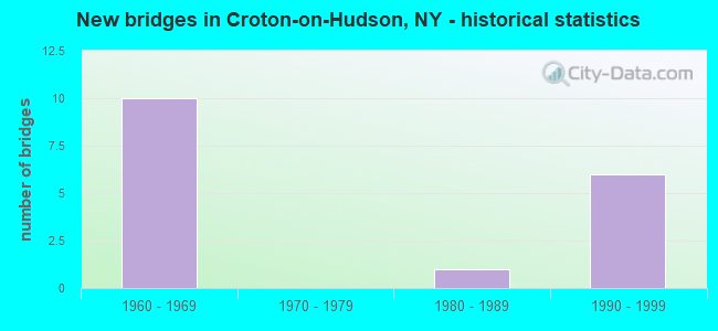
- New bridges - historical statistics
- 101960-1969
- 11980-1989
- 61990-1999
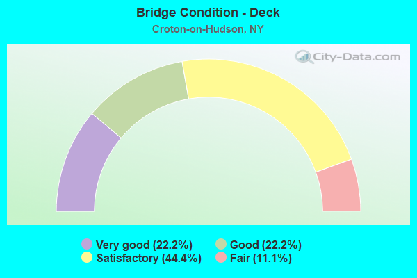
- Bridge Condition - Deck
- 22.2%Very good
- 22.2%Good
- 44.4%Satisfactory
- 11.1%Fair
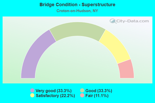
- Bridge Condition - Superstructure
- 33.3%Very good
- 33.3%Good
- 22.2%Satisfactory
- 11.1%Fair
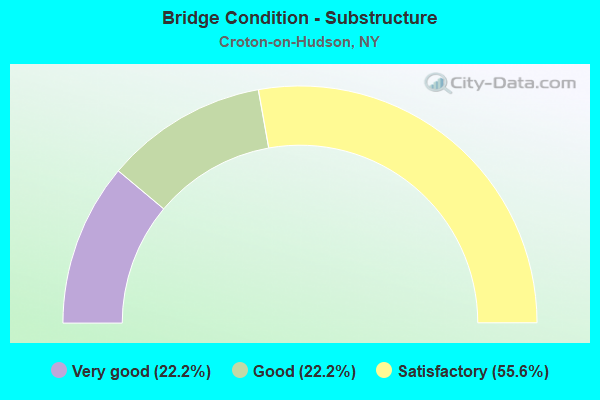
- Bridge Condition - Substructure
- 22.2%Very good
- 22.2%Good
- 55.6%Satisfactory
Find on map >> Show street view
Structure Number: 1004971, Location: 1.2 MI S JCT RTS 9 & 129 (Lat: 41.187231, Lng: -73.874344), Route carried "on" structure: US 9, Year Built: 1998, Status: Open, Structure Length: 14.78m (48.49ft), Average Daily Traffic: 21,347 (year 2020), Truck Traffic: 6%, Average Future Daily Traffic: 30,113 (year 2040), Design Load: HS 25 or greater, Features Intersected: CROTON RIVER
Minimum Vertical Clearance: 30+ m (98+ ft), Kilometerpoint: 32.405, Lanes on structure: 3, Base Highway Network: Yes, Owner: State Highway Agency, Approaching Roadway Width: 14.9m (48.9ft), Material/Design: Steel continuous, Design/Construction: Stringer/Multi-beam, Number Of Spans In Main Unit: 4, Length of Maximum Span: 36.5m (119.8ft), Curb or Sidewalk Widths: Left: 3.7m (12.1ft), Right: 0.0m, Curb-To-Curb Width: 14.6m (47.9ft), Out-to-Out Width: 19.2m (63.0ft)
Condition: Deck: Very good, Superstructure: Very good, Substructure: Very good, Channel: Very good, Operating Rating: 73.5 metric tons, Method Used To Determine Operating Rating: Load Factor (LF), Inventory Rating: 44.5 metric tons, Method Used To Determine Inventory Rating: Load Factor (LF), Structural Evaluation: Equal to present desirable criteria, Deck Geometry: Meets minimum limits, Waterway Adequacy: Equal to present minimum criteria, Approach Roadway Alignment: Equal to present desirable criteria, Length Of Structure Improvement: 14.78m (48.49ft), Designated Inspection Frequency: Every 24 months, Inspection Date: November 2020, Bridge Improvement Cost: $10,708,000, Roadway Improvement Cost: $6,271,000, Total Project Cost: $16,979,000 ( Estimate for 2021), Deck Structure Type: Concrete Cast-file-Place, Wearing Surface/Protective System: Wearing Surface: Integral Concrete, Deck Protection: Epoxy Coated Reinforcing
Find on map >> Show street view
Structure Number: 1004972, Location: 1.2 MI S JCT RTS 9 & 129 (Lat: 41.188139, Lng: -73.875392), Route carried "on" structure: Interstate 9, Year Built: 1998, Status: Open, Structure Length: 14.78m (48.49ft), Average Daily Traffic: 21,347 (year 2020), Truck Traffic: 6%, Average Future Daily Traffic: 30,113 (year 2040), Design Load: HS 25 or greater, Features Intersected: CROTON RIVER
Minimum Vertical Clearance: 30+ m (98+ ft), Kilometerpoint: 32.470, Lanes on structure: 3, Base Highway Network: Yes, Owner: State Highway Agency, Approaching Roadway Width: 14.9m (48.9ft), Material/Design: Steel continuous, Design/Construction: Stringer/Multi-beam, Number Of Spans In Main Unit: 4, Length of Maximum Span: 36.5m (119.8ft), Curb-To-Curb Width: 14.6m (47.9ft), Out-to-Out Width: 15.3m (50.2ft)
Condition: Deck: Very good, Superstructure: Very good, Substructure: Very good, Channel: Very good, Operating Rating: 78.0 metric tons, Method Used To Determine Operating Rating: Load Factor (LF), Inventory Rating: 47.2 metric tons, Method Used To Determine Inventory Rating: Load Factor (LF), Structural Evaluation: Equal to present desirable criteria, Deck Geometry: Meets minimum limits, Waterway Adequacy: Equal to present minimum criteria, Approach Roadway Alignment: Equal to present desirable criteria, Length Of Structure Improvement: 14.78m (48.49ft), Designated Inspection Frequency: Every 24 months, Inspection Date: November 2020, Bridge Improvement Cost: $8,532,000, Roadway Improvement Cost: $4,997,000, Total Project Cost: $13,529,000 ( Estimate for 2021), Deck Structure Type: Concrete Cast-file-Place, Wearing Surface/Protective System: Wearing Surface: Integral Concrete, Deck Protection: Epoxy Coated Reinforcing
Find on map >> Show street view
Structure Number: 1004989, Location: 0.8 MI S JCT RTS 9+129 (Lat: 41.192975, Lng: -73.882050), Route carried "on" structure: US 9, Year Built: 1964, Status: Open, Structure Length: 4.94m (16.21ft), Average Daily Traffic: 35,965 (year 2020), Truck Traffic: 7%, Average Future Daily Traffic: 50,735 (year 2040), Design Load: H 20, Features Intersected: RTE 9A
Minimum Vertical Clearance: 30+ m (98+ ft), Kilometerpoint: 33.306, Lanes on structure: 5, Lanes under structure: 4, Base Highway Network: Yes, Owner: State Highway Agency, Approaching Roadway Width: 29.6m (97.1ft), Skew: 21 degrees, Material/Design: Steel, Design/Construction: Stringer/Multi-beam, Number Of Spans In Main Unit: 3, Length of Maximum Span: 21.6m (70.9ft), Curb-To-Curb Width: 22.1m (72.5ft), Out-to-Out Width: 23.6m (77.4ft)
Condition: Deck: Fair, Superstructure: Fair, Substructure: Satisfactory, Operating Rating: 74.4 metric tons, Method Used To Determine Operating Rating: Load Factor (LF), Inventory Rating: 44.5 metric tons, Method Used To Determine Inventory Rating: Load Factor (LF), Structural Evaluation: Somewhat better than minimum adequacy, Deck Geometry: Meets minimum limits, Underclear: Somewhat better than minimum adequacy, Approach Roadway Alignment: Equal to present desirable criteria, Length Of Structure Improvement: 4.93m (16.17ft), Designated Inspection Frequency: Every 24 months, Inspection Date: April 2021, Bridge Improvement Cost: $4,650,000, Roadway Improvement Cost: $2,723,000, Total Project Cost: $7,373,000 ( Estimate for 2021), Deck Structure Type: Concrete Cast-file-Place, Wearing Surface/Protective System: Wearing Surface: Bituminous, Membrane: Other
Find on map >> Show street view
Structure Number: 1004991, Location: JCT RTS 9+129 (Lat: 41.201469, Lng: -73.887961), Route carried "on" structure: US 9, Year Built: 1963, Status: Open, Structure Length: 4.08m (13.39ft), Average Daily Traffic: 17,983 (year 2020), Truck Traffic: 7%, Average Future Daily Traffic: 25,368 (year 2040), Design Load: HS 20+Mod, Features Intersected: RTE 129
Minimum Vertical Clearance: 30+ m (98+ ft), Kilometerpoint: 34.400, Lanes on structure: 2, Lanes under structure: 4, Base Highway Network: Yes, Owner: State Highway Agency, Approaching Roadway Width: 11.0m (36.1ft), Material/Design: Steel, Design/Construction: Stringer/Multi-beam, Number Of Spans In Main Unit: 3, Length of Maximum Span: 18.2m (59.7ft), Curb-To-Curb Width: 9.1m (29.9ft), Out-to-Out Width: 10.7m (35.1ft)
Condition: Deck: Satisfactory, Superstructure: Satisfactory, Substructure: Satisfactory, Operating Rating: 75.3 metric tons, Method Used To Determine Operating Rating: Load Factor (LF), Inventory Rating: 45.4 metric tons, Method Used To Determine Inventory Rating: Load Factor (LF), Structural Evaluation: Equal to present minimum criteria, Deck Geometry: High priority of replacement, Underclear: Meets minimum limits, Approach Roadway Alignment: Equal to present desirable criteria, Length Of Structure Improvement: 4.08m (13.39ft), Designated Inspection Frequency: Every 24 months, Inspection Date: July 2020, Bridge Improvement Cost: $1,774,000, Roadway Improvement Cost: $1,039,000, Total Project Cost: $2,812,000 ( Estimate for 2021), Deck Structure Type: Concrete Cast-file-Place, Wearing Surface/Protective System: Wearing Surface: Bituminous, Membrane: Other
Find on map >> Show street view
Structure Number: 1004992, Location: JCT RTS 9+129 (Lat: 41.201572, Lng: -73.887839), Route carried "on" structure: US 9, Year Built: 1963, Status: Open, Structure Length: 4.08m (13.39ft), Average Daily Traffic: 17,983 (year 2020), Truck Traffic: 7%, Average Future Daily Traffic: 25,368 (year 2040), Design Load: HS 20+Mod, Features Intersected: RTE 129
Minimum Vertical Clearance: 30+ m (98+ ft), Kilometerpoint: 34.400, Lanes on structure: 2, Lanes under structure: 4, Base Highway Network: Yes, Owner: State Highway Agency, Approaching Roadway Width: 11.0m (36.1ft), Material/Design: Steel, Design/Construction: Stringer/Multi-beam, Number Of Spans In Main Unit: 3, Length of Maximum Span: 18.3m (60.0ft), Curb-To-Curb Width: 9.1m (29.9ft), Out-to-Out Width: 10.7m (35.1ft)
Condition: Deck: Satisfactory, Superstructure: Good, Substructure: Satisfactory, Operating Rating: 75.3 metric tons, Method Used To Determine Operating Rating: Load Factor (LF), Inventory Rating: 45.4 metric tons, Method Used To Determine Inventory Rating: Load Factor (LF), Structural Evaluation: Equal to present minimum criteria, Deck Geometry: High priority of replacement, Underclear: Meets minimum limits, Approach Roadway Alignment: Equal to present desirable criteria, Length Of Structure Improvement: 4.08m (13.39ft), Designated Inspection Frequency: Every 24 months, Inspection Date: July 2020, Bridge Improvement Cost: $1,774,000, Roadway Improvement Cost: $1,039,000, Total Project Cost: $2,812,000 ( Estimate for 2021), Deck Structure Type: Concrete Cast-file-Place, Wearing Surface/Protective System: Wearing Surface: Bituminous, Membrane: Other
Find on map >> Show street view
Structure Number: 100501, Location: .7 MI N JCT US 9 & SH 129 (Lat: 41.209542, Lng: -73.896300), Route carried "on" structure: Other road , Year Built: 1962, Year Reconstructed: 2018, Status: Open, Structure Length: 7.32m (24.02ft), Average Daily Traffic: 829 (year 2017), Truck Traffic: 3%, Average Future Daily Traffic: 1,007 (year 2040), Design Load: HS 20, Features Intersected: 9 9 87032173 SB, Ramp,, Facility Carried by Structure: SENASQUA ROAD
Minimum Vertical Clearance: 30+ m (98+ ft), Kilometerpoint: 0.032, Lanes on structure: 2, Lanes under structure: 5, Owner: State Highway Agency, Approaching Roadway Width: 12.5m (41.0ft), Skew: 21 degrees, Material/Design: Steel, Design/Construction: Stringer/Multi-beam, Number Of Spans In Main Unit: 4, Length of Maximum Span: 23.4m (76.8ft), Curb-To-Curb Width: 11.6m (38.1ft), Out-to-Out Width: 12.6m (41.3ft)
Condition: Deck: Satisfactory, Superstructure: Satisfactory, Substructure: Good, Operating Rating: 62.2 metric tons, Method Used To Determine Operating Rating: Load and Resistance Factor Rating (LRFR) rating reported by rating factor(RF) method using HL-93 loadings, Inventory Rating: 48.0 metric tons, Method Used To Determine Inventory Rating: Load and Resistance Factor Rating (LRFR) rating reported by rating factor(RF) method using HL-93 loadings, Structural Evaluation: Equal to present minimum criteria, Deck Geometry: Better than present minimum criteria, Underclear: Meets minimum limits, Approach Roadway Alignment: Equal to present desirable criteria, Length Of Structure Improvement: 7.31m (23.98ft), Designated Inspection Frequency: Every 24 months, Inspection Date: May 2021, Bridge Improvement Cost: $3,508,000, Roadway Improvement Cost: $2,055,000, Total Project Cost: $5,563,000 ( Estimate for 2021), Deck Structure Type: Concrete Cast-file-Place, Wearing Surface/Protective System: Wearing Surface: Bituminous, Membrane: Other
Find on map >> Show street view
Structure Number: 100502, Location: 2.0 MI N JCT RTS 9+129 (Lat: 41.222169, Lng: -73.912306), Route carried "on" structure: Other road , Year Built: 1963, Status: Open, Structure Length: 5.24m (17.19ft), Average Daily Traffic: 138 (year 2017), Truck Traffic: 4%, Average Future Daily Traffic: 193 (year 2037), Design Load: HS 20, Features Intersected: 9 9 87032186 SB, RTE 9, Facility Carried by Structure: WARREN RD
Minimum Vertical Clearance: 30+ m (98+ ft), Kilometerpoint: 0.113, Lanes on structure: 2, Lanes under structure: 4, Owner: State Highway Agency, Approaching Roadway Width: 7.9m (25.9ft), Material/Design: Steel, Design/Construction: Stringer/Multi-beam, Number Of Spans In Main Unit: 2, Length of Maximum Span: 25.6m (84.0ft), Curb or Sidewalk Widths: Left: 1.1m (3.6ft), Right: 0.0m, Curb-To-Curb Width: 8.5m (27.9ft), Out-to-Out Width: 10.6m (34.8ft)
Condition: Deck: Good, Superstructure: Good, Substructure: Satisfactory, Inventory Rating: 60.8 metric tons, Method Used To Determine Inventory Rating: Load Factor (LF), Structural Evaluation: Equal to present minimum criteria, Deck Geometry: Equal to present minimum criteria, Underclear: Meets minimum limits, Approach Roadway Alignment: Equal to present desirable criteria, Length Of Structure Improvement: 5.24m (17.19ft), Designated Inspection Frequency: Every 24 months, Inspection Date: May 2021, Bridge Improvement Cost: $2,390,000, Roadway Improvement Cost: $1,400,000, Total Project Cost: $3,790,000 ( Estimate for 2021), Deck Structure Type: Concrete Cast-file-Place, Wearing Surface/Protective System: Wearing Surface: Bituminous, Membrane: Other
Find on map >> Show street view
Structure Number: 227005, Location: .5 MI SW JCT SH9A & MAPLE (Lat: 41.198669, Lng: -73.887117), Route carried "on" structure: Other road , Year Built: 1987, Status: Open, Structure Length: 5.12m (16.80ft), Average Daily Traffic: 345 (year 2016), Truck Traffic: 4%, Average Future Daily Traffic: 483 (year 2036), Design Load: HS 20, Features Intersected: MNRR HU LINE, Facility Carried by Structure: HALFMOON BAY ROAD
Minimum Vertical Clearance: 30+ m (98+ ft), Kilometerpoint: 1.545, Lanes on structure: 2, Owner: Town or Township Highway Agency, Approaching Roadway Width: 8.5m (27.9ft), Skew: 1 degrees, Material/Design: Steel, Design/Construction: Stringer/Multi-beam, Number Of Spans In Main Unit: 3, Number Of Approach Spans: 2, Length of Maximum Span: 14.9m (48.9ft), Curb or Sidewalk Widths: Left: 1.4m (4.6ft), Right: 0.0m, Curb-To-Curb Width: 7.6m (24.9ft), Out-to-Out Width: 9.8m (32.2ft)
Condition: Deck: Satisfactory, Superstructure: Good, Substructure: Satisfactory, Operating Rating: 34.5 metric tons, Method Used To Determine Operating Rating: Load Factor (LF), Inventory Rating: 34.5 metric tons, Method Used To Determine Inventory Rating: Load Factor (LF), Structural Evaluation: Equal to present minimum criteria, Deck Geometry: Somewhat better than minimum adequacy, Underclear: High priority of corrective action, Approach Roadway Alignment: Equal to present desirable criteria, Length Of Structure Improvement: 5.12m (16.80ft), Designated Inspection Frequency: Every 24 months, Inspection Date: October 2021, Bridge Improvement Cost: $1,923,000, Roadway Improvement Cost: $1,126,000, Total Project Cost: $3,049,000 ( Estimate for 2021), Wearing Surface/Protective System: Wearing Surface: Bituminous
Find on map >> Show street view
Structure Number: 33479, Location: IN CROTON-ON-HUDSON (Lat: 41.191092, Lng: -73.884792), Route carried "on" structure: Other road , Year Built: 1996, Status: Open, Structure Length: 32.74m (107.41ft), Average Daily Traffic: 3,323 (year 2017), Truck Traffic: 11%, Average Future Daily Traffic: 4,111 (year 2040), Design Load: HS 25 or greater, Features Intersected: YARD ROAD, MNRR HU LINE,, Facility Carried by Structure: CROTON POINT AVE
Minimum Vertical Clearance: 30+ m (98+ ft), Kilometerpoint: 0.274, Lanes on structure: 2, Lanes under structure: 1, Owner: Railroad, Maintenance Responsibility: County Highway Agency, Approaching Roadway Width: 8.5m (27.9ft), Skew: 1 degrees, Material/Design: Steel continuous, Design/Construction: Stringer/Multi-beam, Number Of Spans In Main Unit: 9, Length of Maximum Span: 45.1m (148.0ft), Curb or Sidewalk Widths: Left: 0.0m, Right: 1.7m (5.6ft), Curb-To-Curb Width: 8.5m (27.9ft), Out-to-Out Width: 11.0m (36.1ft)
Condition: Deck: Good, Superstructure: Very good, Substructure: Good, Operating Rating: 84.4 metric tons, Method Used To Determine Operating Rating: Load Factor (LF), Inventory Rating: 43.5 metric tons, Method Used To Determine Inventory Rating: Load Factor (LF), Structural Evaluation: Better than present minimum criteria, Deck Geometry: Meets minimum limits, Underclear: Equal to present minimum criteria, Approach Roadway Alignment: Equal to present desirable criteria, Length Of Structure Improvement: 32.73m (107.38ft), Designated Inspection Frequency: Every 24 months, Inspection Date: November 2020, Bridge Improvement Cost: $13,349,000, Roadway Improvement Cost: $7,817,000, Total Project Cost: $21,165,000 ( Estimate for 2021), Deck Structure Type: Concrete Cast-file-Place, Wearing Surface/Protective System: Wearing Surface: Integral Concrete, Deck Protection: Epoxy Coated Reinforcing
Find on map >> Show street view
Structure Number: 1004989, Location: 0.8 MI S JCT RTS 9+129 (Lat: 41.192975, Lng: -73.882050), Route carried "under" structure: State highway 9A, Year Built: 1964, Structure Length: 0. m, Average Daily Traffic: 30,958 (year 2000), Features Intersected: RTE 9A, Facility Carried by Structure: RTE 9
Minimum Vertical Clearance: 6.12m (20.08ft), Kilometerpoint: 26.130, Lanes on structure: 5, Lanes under structure: 4, Material/Design: Steel, Design/Construction: Stringer/Multi-beam, Length of Maximum Span: 21.6m (70.9ft)
Find on map >> Show street view
Structure Number: 1004991, Location: JCT RTS 9+129 (Lat: 41.201469, Lng: -73.887961), Route carried "under" structure: Ramp State highway 129, Year Built: 1963, Structure Length: 0. m, Average Daily Traffic: 8,899 (year 2002), Features Intersected: RTE 129, Facility Carried by Structure: RTE 9
Minimum Vertical Clearance: 4.87m (15.98ft), Kilometerpoint: 1.577, Lanes on structure: 2, Lanes under structure: 4, Material/Design: Steel, Design/Construction: Stringer/Multi-beam, Length of Maximum Span: 18.2m (59.7ft)
Find on map >> Show street view
Structure Number: 1004992, Location: JCT RTS 9+129 (Lat: 41.201572, Lng: -73.887839), Route carried "under" structure: Ramp State highway 129, Year Built: 1963, Structure Length: 0. m, Average Daily Traffic: 8,899 (year 2002), Features Intersected: RTE 129, Facility Carried by Structure: RTE 9
Minimum Vertical Clearance: 4.78m (15.68ft), Kilometerpoint: 1.577, Lanes on structure: 2, Lanes under structure: 4, Material/Design: Steel, Design/Construction: Stringer/Multi-beam, Length of Maximum Span: 18.3m (60.0ft)
Find on map >> Show street view
Structure Number: 100501, Location: .7 MI N JCT US 9 & SH 129 (Lat: 41.209542, Lng: -73.896300), Route carried "under" structure: US 9, Year Built: 1962, Structure Length: 0. m, Average Daily Traffic: 38,475 (year 1999), Features Intersected: 9 9 87032173 SB, Ramp,, Facility Carried by Structure: SENASQUA ROAD
Minimum Vertical Clearance: 5.71m (18.73ft), Kilometerpoint: 27.868, Lanes on structure: 2, Lanes under structure: 2, Material/Design: Steel, Design/Construction: Stringer/Multi-beam, Length of Maximum Span: 23.4m (76.8ft)
Find on map >> Show street view
Structure Number: 100502, Location: 2.0 MI N JCT RTS 9+129 (Lat: 41.222169, Lng: -73.912306), Route carried "under" structure: US 9, Year Built: 1963, Structure Length: 0. m, Average Daily Traffic: 38,475 (year 1999), Features Intersected: 9 9 87032186 SB, RTE 9, Facility Carried by Structure: WARREN RD
Minimum Vertical Clearance: 5.15m (16.90ft), Kilometerpoint: 29.992, Lanes on structure: 2, Lanes under structure: 2, Material/Design: Steel, Design/Construction: Stringer/Multi-beam, Length of Maximum Span: 25.6m (84.0ft)
Find on map >> Show street view
Structure Number: 226866, Location: 1.7 MI N OF US9 / CROTON (Lat: 41.205717, Lng: -73.892669), Route carried "under" structure: US 9, Year Built: 1998, Structure Length: 0. m, Average Daily Traffic: 38,475 (year 1999), Features Intersected: 9 9 87032170 NB, RTE 9, Facility Carried by Structure: PEDESTRIAN BRIDGE
Minimum Vertical Clearance: 7.99m (26.21ft), Kilometerpoint: 27.353, Lanes under structure: 2, Material/Design: Steel, Design/Construction: Stringer/Multi-beam, Length of Maximum Span: 36.2m (118.8ft)
Find on map >> Show street view
Structure Number: 226866, Location: 1.7 MI N OF US9 / CROTON (Lat: 41.205717, Lng: -73.892669), Route carried "under" structure: US , Year Built: 1998, Structure Length: 0. m, Features Intersected: 9 9 87032170 NB, RTE 9, Facility Carried by Structure: PEDESTRIAN BRIDGE
Minimum Vertical Clearance: 5.79m (19.00ft), Kilometerpoint: 27.353, Lanes under structure: 2, Material/Design: Steel, Design/Construction: Stringer/Multi-beam, Length of Maximum Span: 36.2m (118.8ft)
Find on map >> Show street view
Structure Number: 33479, Location: IN CROTON-ON-HUDSON (Lat: 41.191092, Lng: -73.884792), Route carried "under" structure: Other road , Year Built: 1996, Structure Length: 0. m, Average Daily Traffic: 1,000 (year 2021), Features Intersected: YARD ROAD, MNRR HU LINE,, Facility Carried by Structure: CROTON POINT AVE
Minimum Vertical Clearance: 4.85m (15.91ft), Kilometerpoint: 0.000, Lanes on structure: 2, Lanes under structure: 1, Material/Design: Steel continuous, Design/Construction: Stringer/Multi-beam, Length of Maximum Span: 45.1m (148.0ft)