Bridge Statistics for Crown Point, Indiana (IN)
Condition, Traffic, Stress, Structural Evaluation, Project Costs
- National Bridge Inventory (NBI) Statistics
- 36Number of bridges
- 259ft / 79.0mTotal length
- $1,328,000Total costs
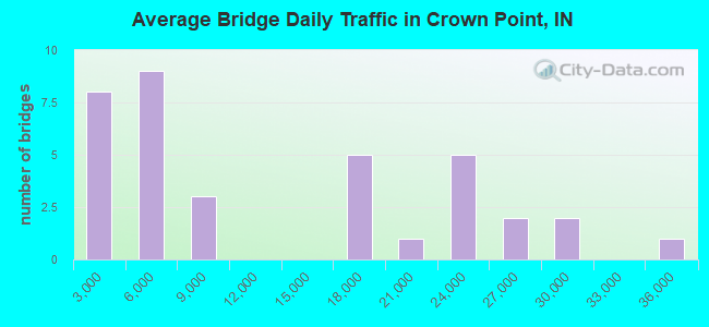
- 429,075Total average daily traffic
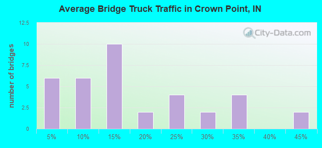
- 99,022Total average daily truck traffic
- National Bridge Inventory (NBI) Registered Bridges for Crown Point
- No street view available for this location
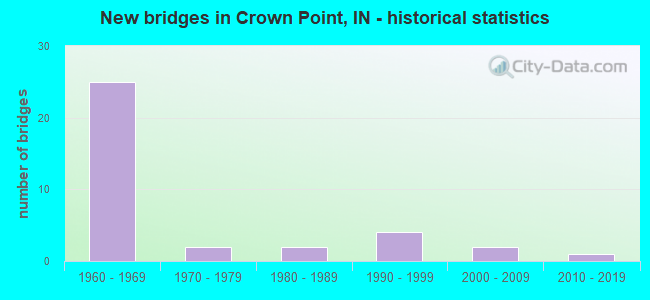
- New bridges - historical statistics
- 251960-1969
- 21970-1979
- 21980-1989
- 41990-1999
- 22000-2009
- 12010-2019
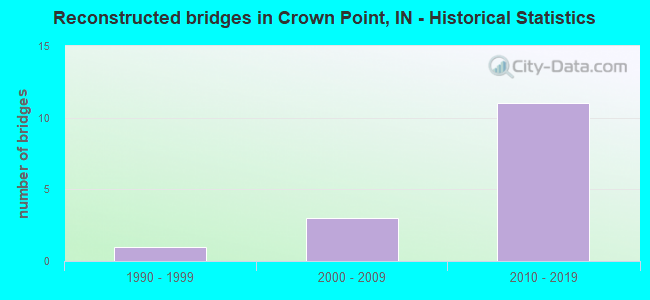
- Reconstructed bridges - Historical Statistics
- 11990-1999
- 32000-2009
- 112010-2019
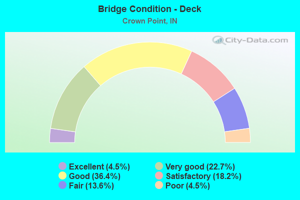
- Bridge Condition - Deck
- 4.5%Excellent
- 22.7%Very good
- 36.4%Good
- 18.2%Satisfactory
- 13.6%Fair
- 4.5%Poor
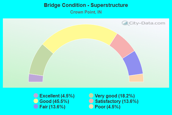
- Bridge Condition - Superstructure
- 4.5%Excellent
- 18.2%Very good
- 45.5%Good
- 13.6%Satisfactory
- 13.6%Fair
- 4.5%Poor
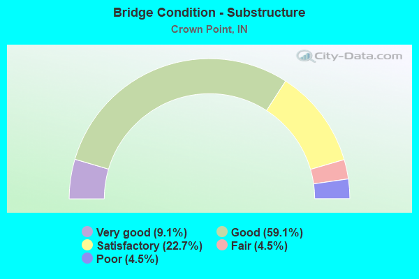
- Bridge Condition - Substructure
- 9.1%Very good
- 59.1%Good
- 22.7%Satisfactory
- 4.5%Fair
- 4.5%Poor
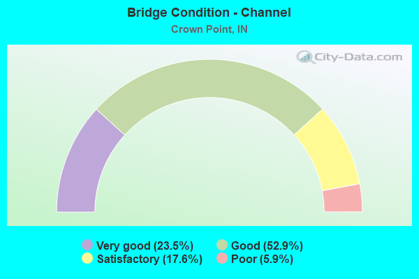
- Bridge Condition - Channel
- 23.5%Very good
- 52.9%Good
- 17.6%Satisfactory
- 5.9%Poor
Find on map >> Show street view
Structure Number: 1947, Location: 01.93 N US 231 (Lat: 41.428481, Lng: -87.335472), Route carried "on" structure: State highway 53, Year Built: 1996, Year Reconstructed: 2015, Status: Open, Structure Length: 2.38m (7.81ft), Average Daily Traffic: 15,088 (year 2004), Truck Traffic: 5%, Average Future Daily Traffic: 21,259 (year 2030), Design Load: HS 20, Features Intersected: BEAVER DAM DITCH
Minimum Vertical Clearance: 30+ m (98+ ft), Kilometerpoint: 3.106, Lanes on structure: 2, Owner: State Highway Agency, Approaching Roadway Width: 10.1m (33.1ft), Skew: 3 degrees, Material/Design: Concrete continuous, Design/Construction: Slab, Number Of Spans In Main Unit: 3, Length of Maximum Span: 9.3m (30.5ft), Curb-To-Curb Width: 21.1m (69.2ft), Out-to-Out Width: 22.0m (72.2ft)
Condition: Deck: Satisfactory, Superstructure: Satisfactory, Substructure: Good, Channel: Very good, Operating Rating: 36.9 metric tons, Method Used To Determine Operating Rating: Load and Resistance Factor Rating (LRFR) rating reported by rating factor(RF) method using HL-93 loadings, Inventory Rating: 28.5 metric tons, Method Used To Determine Inventory Rating: Load and Resistance Factor Rating (LRFR) rating reported by rating factor(RF) method using HL-93 loadings, Structural Evaluation: Equal to present minimum criteria, Deck Geometry: Superior to present desirable criteria, Waterway Adequacy: Superior to present desirable criteria, Approach Roadway Alignment: Equal to present desirable criteria, Designated Inspection Frequency: Every 24 months, Inspection Date: Febuary 2021, Deck Structure Type: Concrete Cast-file-Place, Wearing Surface/Protective System: Wearing Surface: Latex Concrete, Deck Protection: Epoxy Coated Reinforcing
Find on map >> Show street view
Structure Number: 1987, Location: 01.40 N US 231 (Lat: 41.438161, Lng: -87.364739), Route carried "on" structure: State highway 55, Year Built: 1985, Year Reconstructed: 2015, Status: Open, Structure Length: 2.13m (6.99ft), Average Daily Traffic: 24,373 (year 2004), Truck Traffic: 5%, Average Future Daily Traffic: 34,342 (year 2030), Design Load: HS 20, Features Intersected: MAIN BEAVER DAM DITCH
Minimum Vertical Clearance: 30+ m (98+ ft), Kilometerpoint: 30.513, Lanes on structure: 5, Owner: State Highway Agency, Approaching Roadway Width: 19.2m (63.0ft), Skew: 1 degrees, Material/Design: Concrete continuous, Design/Construction: Slab, Number Of Spans In Main Unit: 3, Length of Maximum Span: 7.8m (25.6ft), Curb or Sidewalk Widths: Left: 1.8m (5.9ft), Right: 1.8m (5.9ft), Curb-To-Curb Width: 19.1m (62.7ft), Out-to-Out Width: 23.5m (77.1ft)
Condition: Deck: Good, Superstructure: Good, Substructure: Satisfactory, Channel: Satisfactory, Operating Rating: 37.3 metric tons, Method Used To Determine Operating Rating: Load and Resistance Factor Rating (LRFR) rating reported by rating factor(RF) method using HL-93 loadings, Inventory Rating: 28.8 metric tons, Method Used To Determine Inventory Rating: Load and Resistance Factor Rating (LRFR) rating reported by rating factor(RF) method using HL-93 loadings, Structural Evaluation: Equal to present minimum criteria, Deck Geometry: Meets minimum limits, Waterway Adequacy: Superior to present desirable criteria, Approach Roadway Alignment: Equal to present desirable criteria, Designated Inspection Frequency: Every 24 months, Inspection Date: September 2021, Deck Structure Type: Concrete Cast-file-Place, Wearing Surface/Protective System: Wearing Surface: Latex Concrete, Deck Protection: Epoxy Coated Reinforcing
Find on map >> Show street view
Structure Number: 384, Location: 03.58 N SR 2 (Lat: 41.340081, Lng: -87.308908), Route carried "on" structure: Alternate County highway , Year Built: 1964, Year Reconstructed: 2018, Status: Open, Structure Length: 6.58m (21.59ft), Average Daily Traffic: 428 (year 2004), Truck Traffic: 10%, Average Future Daily Traffic: 711 (year 2030), Design Load: HS 20, Features Intersected: I-65 NB/SB, Facility Carried by Structure: CR H-10/153RD AVE
Minimum Vertical Clearance: 30+ m (98+ ft), Kilometerpoint: 0.000, Lanes on structure: 2, Lanes under structure: 4, Owner: State Highway Agency, Approaching Roadway Width: 7.3m (24.0ft), Skew: 1 degrees, Material/Design: Steel continuous, Design/Construction: Stringer/Multi-beam, Number Of Spans In Main Unit: 2, Number Of Approach Spans: 2, Length of Maximum Span: 20.7m (67.9ft), Curb-To-Curb Width: 8.0m (26.2ft), Out-to-Out Width: 8.9m (29.2ft)
Condition: Deck: Fair, Superstructure: Fair, Substructure: Good, Operating Rating: 32.1 metric tons, Method Used To Determine Operating Rating: Load and Resistance Factor Rating (LRFR) rating reported by rating factor(RF) method using HL-93 loadings, Inventory Rating: 24.6 metric tons, Method Used To Determine Inventory Rating: Load and Resistance Factor Rating (LRFR) rating reported by rating factor(RF) method using HL-93 loadings, Structural Evaluation: Somewhat better than minimum adequacy, Deck Geometry: Somewhat better than minimum adequacy, Underclear: Meets minimum limits, Approach Roadway Alignment: Equal to present desirable criteria, Designated Inspection Frequency: Every 24 months, Inspection Date: April 2021, Deck Structure Type: Concrete Cast-file-Place, Wearing Surface/Protective System: Wearing Surface: Latex Concrete
Find on map >> Show street view
Structure Number: 3841, Location: 04.81 N SR 2 (Lat: 41.357561, Lng: -87.315689), Route carried "on" structure: Interstate 65, Year Built: 1964, Year Reconstructed: 2018, Status: Open, Structure Length: 3.46m (11.35ft), Average Daily Traffic: 25,990 (year 2015), Truck Traffic: 44%, Average Future Daily Traffic: 31,464 (year 2035), Design Load: HS 20, Features Intersected: WIRTZ DITCH
Minimum Vertical Clearance: 30+ m (98+ ft), Kilometerpoint: 392.873, Lanes on structure: 2, Base Highway Network: Yes (, Subroute: 1), Owner: State Highway Agency, Approaching Roadway Width: 17.1m (56.1ft), Skew: 4 degrees, Material/Design: Prestressed concrete continuous, Design/Construction: Stringer/Multi-beam, Number Of Spans In Main Unit: 3, Length of Maximum Span: 11.3m (37.1ft), Curb-To-Curb Width: 17.1m (56.1ft), Out-to-Out Width: 18.0m (59.1ft)
Condition: Deck: Very good, Superstructure: Very good, Substructure: Good, Channel: Good, Operating Rating: 58.0 metric tons, Method Used To Determine Operating Rating: Load and Resistance Factor Rating (LRFR) rating reported by rating factor(RF) method using HL-93 loadings, Inventory Rating: 26.9 metric tons, Method Used To Determine Inventory Rating: Load and Resistance Factor Rating (LRFR) rating reported by rating factor(RF) method using HL-93 loadings, Structural Evaluation: Equal to present minimum criteria, Deck Geometry: Superior to present desirable criteria, Waterway Adequacy: Superior to present desirable criteria, Approach Roadway Alignment: Equal to present desirable criteria, Designated Inspection Frequency: Every 24 months, Inspection Date: April 2021, Deck Structure Type: Concrete Cast-file-Place, Wearing Surface/Protective System: Wearing Surface: Latex Concrete, Deck Protection: Epoxy Coated Reinforcing
Find on map >> Show street view
Structure Number: 3842, Location: 04.81 N SR 2 (Lat: 41.357689, Lng: -87.316072), Route carried "on" structure: Interstate 65, Year Built: 1964, Year Reconstructed: 2018, Status: Open, Structure Length: 3.46m (11.35ft), Average Daily Traffic: 19,607 (year 2015), Truck Traffic: 44%, Average Future Daily Traffic: 23,736 (year 2035), Design Load: HS 20, Features Intersected: WIRTZ DITCH
Minimum Vertical Clearance: 30+ m (98+ ft), Kilometerpoint: 392.873, Lanes on structure: 3, Base Highway Network: Yes (, Subroute: 1), Owner: State Highway Agency, Approaching Roadway Width: 17.1m (56.1ft), Skew: 4 degrees, Material/Design: Prestressed concrete continuous, Design/Construction: Stringer/Multi-beam, Number Of Spans In Main Unit: 3, Length of Maximum Span: 11.3m (37.1ft), Curb-To-Curb Width: 17.1m (56.1ft), Out-to-Out Width: 18.0m (59.1ft)
Condition: Deck: Very good, Superstructure: Very good, Substructure: Good, Channel: Very good, Operating Rating: 58.0 metric tons, Method Used To Determine Operating Rating: Load and Resistance Factor Rating (LRFR) rating reported by rating factor(RF) method using HL-93 loadings, Inventory Rating: 26.9 metric tons, Method Used To Determine Inventory Rating: Load and Resistance Factor Rating (LRFR) rating reported by rating factor(RF) method using HL-93 loadings, Structural Evaluation: Equal to present minimum criteria, Deck Geometry: Equal to present minimum criteria, Waterway Adequacy: Superior to present desirable criteria, Approach Roadway Alignment: Equal to present desirable criteria, Designated Inspection Frequency: Every 24 months, Inspection Date: April 2021, Deck Structure Type: Concrete Cast-file-Place, Wearing Surface/Protective System: Wearing Surface: Latex Concrete, Deck Protection: Epoxy Coated Reinforcing
Find on map >> Show street view
Structure Number: 3843, Location: 01.73 S US 231 (Lat: 41.369211, Lng: -87.320458), Route carried "on" structure: Alternate County highway , Year Built: 1964, Year Reconstructed: 2018, Status: Open, Structure Length: 6.56m (21.52ft), Average Daily Traffic: 431 (year 2015), Truck Traffic: 5%, Average Future Daily Traffic: 641 (year 2035), Design Load: HS 20, Features Intersected: I-65 NB/SB, Facility Carried by Structure: CR H-4/137TH AVE
Minimum Vertical Clearance: 30+ m (98+ ft), Kilometerpoint: 0.000, Lanes on structure: 2, Lanes under structure: 6, Owner: State Highway Agency, Approaching Roadway Width: 7.3m (24.0ft), Skew: 1 degrees, Material/Design: Steel continuous, Design/Construction: Stringer/Multi-beam, Number Of Spans In Main Unit: 2, Number Of Approach Spans: 2, Length of Maximum Span: 20.9m (68.6ft), Curb-To-Curb Width: 8.0m (26.2ft), Out-to-Out Width: 8.9m (29.2ft)
Condition: Deck: Satisfactory, Superstructure: Fair, Substructure: Satisfactory, Operating Rating: 38.6 metric tons, Method Used To Determine Operating Rating: Load and Resistance Factor Rating (LRFR) rating reported by rating factor(RF) method using HL-93 loadings, Inventory Rating: 29.8 metric tons, Method Used To Determine Inventory Rating: Load and Resistance Factor Rating (LRFR) rating reported by rating factor(RF) method using HL-93 loadings, Structural Evaluation: Somewhat better than minimum adequacy, Deck Geometry: Somewhat better than minimum adequacy, Underclear: Meets minimum limits, Approach Roadway Alignment: Equal to present desirable criteria, Designated Inspection Frequency: Every 24 months, Inspection Date: April 2021, Deck Structure Type: Concrete Cast-file-Place, Wearing Surface/Protective System: Wearing Surface: Latex Concrete
Find on map >> Show street view
Structure Number: 3844, Location: 05.38 S US 30 (Lat: 41.393450, Lng: -87.323861), Route carried "on" structure: Interstate 65, Year Built: 1964, Year Reconstructed: 2018, Status: Open, Structure Length: 9.45m (31.00ft), Average Daily Traffic: 28,977 (year 2015), Truck Traffic: 34%, Average Future Daily Traffic: 29,526 (year 2035), Design Load: HS 20+Mod, Features Intersected: US 231 NB/SB, ABANDONED
Minimum Vertical Clearance: 30+ m (98+ ft), Kilometerpoint: 396.993, Lanes on structure: 4, Lanes under structure: 4, Base Highway Network: Yes (, Subroute: 1), Owner: State Highway Agency, Approaching Roadway Width: 20.7m (67.9ft), Skew: 2 degrees, Material/Design: Steel continuous, Design/Construction: Stringer/Multi-beam, Number Of Spans In Main Unit: 5, Length of Maximum Span: 25.3m (83.0ft), Curb-To-Curb Width: 20.8m (68.2ft), Out-to-Out Width: 21.7m (71.2ft)
Condition: Deck: Very good, Superstructure: Very good, Substructure: Good, Operating Rating: 57.0 metric tons, Method Used To Determine Operating Rating: Load Factor (LF), Inventory Rating: 34.1 metric tons, Method Used To Determine Inventory Rating: Load Factor (LF), Structural Evaluation: Better than present minimum criteria, Deck Geometry: Equal to present minimum criteria, Underclear: Superior to present desirable criteria, Approach Roadway Alignment: Equal to present desirable criteria, Designated Inspection Frequency: Every 24 months, Inspection Date: April 2021, Deck Structure Type: Concrete Cast-file-Place, Wearing Surface/Protective System: Wearing Surface: Monolithic Concrete, Deck Protection: Epoxy Coated Reinforcing
Find on map >> Show street view
Structure Number: 3845, Location: 05.38 S US 30 (Lat: 41.393669, Lng: -87.324161), Route carried "on" structure: Interstate 65, Year Built: 1964, Year Reconstructed: 2018, Status: Open, Structure Length: 9.44m (30.97ft), Average Daily Traffic: 21,860 (year 2015), Truck Traffic: 34%, Average Future Daily Traffic: 22,274 (year 2035), Design Load: HS 20, Features Intersected: US 231 NB/SB, ABANDONED
Minimum Vertical Clearance: 30+ m (98+ ft), Kilometerpoint: 396.993, Lanes on structure: 4, Lanes under structure: 4, Base Highway Network: Yes (, Subroute: 1), Owner: State Highway Agency, Approaching Roadway Width: 20.7m (67.9ft), Skew: 2 degrees, Material/Design: Steel continuous, Design/Construction: Stringer/Multi-beam, Number Of Spans In Main Unit: 5, Length of Maximum Span: 25.3m (83.0ft), Curb-To-Curb Width: 20.7m (67.9ft), Out-to-Out Width: 21.6m (70.9ft)
Condition: Deck: Very good, Superstructure: Good, Substructure: Very good, Operating Rating: 52.1 metric tons, Method Used To Determine Operating Rating: Load and Resistance Factor (LRFR), Inventory Rating: 50.0 metric tons, Method Used To Determine Inventory Rating: Load and Resistance Factor (LRFR), Structural Evaluation: Better than present minimum criteria, Deck Geometry: Equal to present minimum criteria, Underclear: Superior to present desirable criteria, Approach Roadway Alignment: Equal to present desirable criteria, Designated Inspection Frequency: Every 24 months, Inspection Date: April 2021, Deck Structure Type: Concrete Cast-file-Place, Wearing Surface/Protective System: Wearing Surface: Monolithic Concrete, Deck Protection: Epoxy Coated Reinforcing
Find on map >> Show street view
Structure Number: 3846, Location: 01.36 N US 231 (Lat: 41.412900, Lng: -87.321458), Route carried "on" structure: Alternate County highway , Year Built: 1965, Year Reconstructed: 2004, Status: Open, Structure Length: 6.32m (20.73ft), Average Daily Traffic: 3,247 (year 2004), Truck Traffic: 10%, Average Future Daily Traffic: 6,300 (year 2030), Design Load: HS 20, Features Intersected: I-65, Facility Carried by Structure: 113TH AVENUE
Minimum Vertical Clearance: 30+ m (98+ ft), Kilometerpoint: 399.257, Lanes on structure: 2, Lanes under structure: 4, Owner: State Highway Agency, Approaching Roadway Width: 6.1m (20.0ft), Material/Design: Steel continuous, Design/Construction: Stringer/Multi-beam, Number Of Spans In Main Unit: 2, Number Of Approach Spans: 2, Length of Maximum Span: 19.8m (65.0ft), Curb-To-Curb Width: 8.1m (26.6ft), Out-to-Out Width: 9.0m (29.5ft)
Condition: Deck: Fair, Superstructure: Satisfactory, Substructure: Satisfactory, Operating Rating: 57.0 metric tons, Method Used To Determine Operating Rating: Load Factor (LF), Inventory Rating: 34.1 metric tons, Method Used To Determine Inventory Rating: Load Factor (LF), Structural Evaluation: Equal to present minimum criteria, Deck Geometry: High priority of corrective action, Underclear: Equal to present minimum criteria, Approach Roadway Alignment: Equal to present desirable criteria, Designated Inspection Frequency: Every 24 months, Inspection Date: April 2021, Deck Structure Type: Concrete Cast-file-Place, Wearing Surface/Protective System: Wearing Surface: Latex Concrete
Find on map >> Show street view
Structure Number: 3849, Location: 01.86 N US 231 (Lat: 41.420161, Lng: -87.321319), Route carried "on" structure: Interstate 65, Year Built: 1965, Year Reconstructed: 2018, Status: Open, Structure Length: 3.54m (11.61ft), Average Daily Traffic: 22,253 (year 2004), Truck Traffic: 34%, Average Future Daily Traffic: 40,300 (year 2030), Design Load: HS 20+Mod, Features Intersected: 109TH AVENUE
Minimum Vertical Clearance: 30+ m (98+ ft), Kilometerpoint: 399.986, Lanes on structure: 2, Lanes under structure: 2, Base Highway Network: Yes (, Subroute: 1), Owner: State Highway Agency, Approaching Roadway Width: 19.5m (64.0ft), Material/Design: Steel continuous, Design/Construction: Stringer/Multi-beam, Number Of Spans In Main Unit: 3, Length of Maximum Span: 13.7m (44.9ft), Curb-To-Curb Width: 19.5m (64.0ft), Out-to-Out Width: 20.3m (66.6ft)
Condition: Deck: Good, Superstructure: Good, Substructure: Good, Operating Rating: 65.4 metric tons, Method Used To Determine Operating Rating: Load and Resistance Factor Rating (LRFR) rating reported by rating factor(RF) method using HL-93 loadings, Inventory Rating: 50.2 metric tons, Method Used To Determine Inventory Rating: Load and Resistance Factor Rating (LRFR) rating reported by rating factor(RF) method using HL-93 loadings, Structural Evaluation: Better than present minimum criteria, Deck Geometry: Superior to present desirable criteria, Underclear: Meets minimum limits, Approach Roadway Alignment: Equal to present desirable criteria, Designated Inspection Frequency: Every 24 months, Inspection Date: April 2021, Deck Structure Type: Concrete Cast-file-Place, Wearing Surface/Protective System: Wearing Surface: Epoxy Overlay
Find on map >> Show street view
Structure Number: 385, Location: 01.86 N US 231 (Lat: 41.420150, Lng: -87.321625), Route carried "on" structure: Interstate 65, Year Built: 1965, Year Reconstructed: 2018, Status: Open, Structure Length: 3.54m (11.61ft), Average Daily Traffic: 22,253 (year 2004), Truck Traffic: 34%, Average Future Daily Traffic: 40,300 (year 2030), Design Load: HS 20+Mod, Features Intersected: 109TH AVENUE
Minimum Vertical Clearance: 30+ m (98+ ft), Kilometerpoint: 399.986, Lanes on structure: 2, Lanes under structure: 2, Base Highway Network: Yes (, Subroute: 1), Owner: State Highway Agency, Approaching Roadway Width: 19.5m (64.0ft), Material/Design: Steel continuous, Design/Construction: Stringer/Multi-beam, Number Of Spans In Main Unit: 3, Length of Maximum Span: 13.7m (44.9ft), Curb-To-Curb Width: 19.5m (64.0ft), Out-to-Out Width: 20.3m (66.6ft)
Condition: Deck: Good, Superstructure: Good, Substructure: Good, Operating Rating: 65.4 metric tons, Method Used To Determine Operating Rating: Load and Resistance Factor Rating (LRFR) rating reported by rating factor(RF) method using HL-93 loadings, Inventory Rating: 50.2 metric tons, Method Used To Determine Inventory Rating: Load and Resistance Factor Rating (LRFR) rating reported by rating factor(RF) method using HL-93 loadings, Structural Evaluation: Better than present minimum criteria, Deck Geometry: Superior to present desirable criteria, Underclear: Meets minimum limits, Approach Roadway Alignment: Equal to present desirable criteria, Designated Inspection Frequency: Every 24 months, Inspection Date: April 2021, Deck Structure Type: Concrete Cast-file-Place, Wearing Surface/Protective System: Wearing Surface: Epoxy Overlay
Find on map >> Show street view
Structure Number: 3851, Location: 02.16 N US 231 N JCT (Lat: 41.424439, Lng: -87.321331), Route carried "on" structure: Interstate 65, Year Built: 1966, Year Reconstructed: 2009, Status: Open, Structure Length: 2.79m (9.15ft), Average Daily Traffic: 35,847 (year 2015), Truck Traffic: 28%, Average Future Daily Traffic: 38,418 (year 2035), Design Load: HS 20+Mod, Features Intersected: MAIN BEAVER DAM DITCH
Minimum Vertical Clearance: 30+ m (98+ ft), Kilometerpoint: 400.469, Lanes on structure: 4, Base Highway Network: Yes (, Subroute: 1), Owner: State Highway Agency, Approaching Roadway Width: 23.2m (76.1ft), Skew: 2 degrees, Material/Design: Concrete continuous, Design/Construction: Slab, Number Of Spans In Main Unit: 3, Length of Maximum Span: 11.0m (36.1ft), Curb-To-Curb Width: 27.2m (89.2ft), Out-to-Out Width: 28.1m (92.2ft)
Condition: Deck: Good, Superstructure: Good, Substructure: Good, Channel: Good, Operating Rating: 36.6 metric tons, Method Used To Determine Operating Rating: Load and Resistance Factor Rating (LRFR) rating reported by rating factor(RF) method using HL-93 loadings, Inventory Rating: 28.2 metric tons, Method Used To Determine Inventory Rating: Load and Resistance Factor Rating (LRFR) rating reported by rating factor(RF) method using HL-93 loadings, Structural Evaluation: Better than present minimum criteria, Deck Geometry: Superior to present desirable criteria, Waterway Adequacy: Superior to present desirable criteria, Approach Roadway Alignment: Equal to present desirable criteria, Designated Inspection Frequency: Every 24 months, Inspection Date: April 2021, Deck Structure Type: Concrete Cast-file-Place, Wearing Surface/Protective System: Wearing Surface: Epoxy Overlay, Deck Protection: Epoxy Coated Reinforcing
Find on map >> Show street view
Structure Number: 3852, Location: 02.16 N US 231 N JCT (Lat: 41.424531, Lng: -87.321608), Route carried "on" structure: Interstate 65, Year Built: 1966, Year Reconstructed: 2009, Status: Open, Structure Length: 2.79m (9.15ft), Average Daily Traffic: 27,043 (year 2015), Truck Traffic: 28%, Average Future Daily Traffic: 28,982 (year 2035), Design Load: HS 20+Mod, Features Intersected: MAIN BEAVER DAM DITCH
Minimum Vertical Clearance: 30+ m (98+ ft), Kilometerpoint: 400.469, Lanes on structure: 4, Base Highway Network: Yes (, Subroute: 1), Owner: State Highway Agency, Approaching Roadway Width: 25.0m (82.0ft), Skew: 2 degrees, Material/Design: Concrete continuous, Design/Construction: Slab, Number Of Spans In Main Unit: 3, Length of Maximum Span: 11.0m (36.1ft), Curb-To-Curb Width: 28.8m (94.5ft), Out-to-Out Width: 29.7m (97.4ft)
Condition: Deck: Good, Superstructure: Good, Substructure: Good, Channel: Good, Operating Rating: 36.6 metric tons, Method Used To Determine Operating Rating: Load and Resistance Factor Rating (LRFR) rating reported by rating factor(RF) method using HL-93 loadings, Inventory Rating: 28.2 metric tons, Method Used To Determine Inventory Rating: Load and Resistance Factor Rating (LRFR) rating reported by rating factor(RF) method using HL-93 loadings, Structural Evaluation: Better than present minimum criteria, Deck Geometry: Superior to present desirable criteria, Waterway Adequacy: Superior to present desirable criteria, Approach Roadway Alignment: Equal to present desirable criteria, Designated Inspection Frequency: Every 24 months, Inspection Date: April 2021, Deck Structure Type: Concrete Cast-file-Place, Wearing Surface/Protective System: Wearing Surface: Epoxy Overlay, Deck Protection: Epoxy Coated Reinforcing
Find on map >> Show street view
Structure Number: 4500027, Location: 00.50 W of ARIZONA (Lat: 41.354650, Lng: -87.301750), Route carried "on" structure: County highway , Year Built: 1997, Status: Open, Structure Length: 1.31m (4.30ft), Average Daily Traffic: 124 (year 2012), Truck Traffic: 1%, Average Future Daily Traffic: 164 (year 2020), Design Load: HS 20, Features Intersected: STONEY RUN DITCH, Facility Carried by Structure: 145TH AVENUE
Minimum Vertical Clearance: 30+ m (98+ ft), Kilometerpoint: 0.000, Lanes on structure: 2, Owner: County Highway Agency, Approaching Roadway Width: 6.2m (20.3ft), Material/Design: Prestressed concrete, Design/Construction: Box Beam or Girders - Single/Spread, Number Of Spans In Main Unit: 1, Length of Maximum Span: 12.2m (40.0ft), Curb-To-Curb Width: 8.5m (27.9ft), Out-to-Out Width: 8.7m (28.5ft)
Condition: Deck: Very good, Superstructure: Very good, Substructure: Good, Channel: Good, Operating Rating: 54.5 metric tons, Method Used To Determine Operating Rating: Field evaluation and documented engineering judgment, Inventory Rating: 32.7 metric tons, Method Used To Determine Inventory Rating: Field evaluation and documented engineering judgment, Structural Evaluation: Better than present minimum criteria, Deck Geometry: Equal to present minimum criteria, Waterway Adequacy: Superior to present desirable criteria, Approach Roadway Alignment: Equal to present desirable criteria, Designated Inspection Frequency: Every 24 months, Inspection Date: August 2020, Deck Structure Type: Concrete Cast-file-Place, Wearing Surface/Protective System: Wearing Surface: Monolithic Concrete, Deck Protection: Epoxy Coated Reinforcing
Find on map >> Show street view
Structure Number: 4500056, Location: 00.10 S. of 101st Ave (Lat: 41.432011, Lng: -87.340361), Route carried "on" structure: City street , Year Built: 1988, Status: Posted for load, Structure Length: 1.88m (6.17ft), Average Daily Traffic: 1,622 (year 2012), Truck Traffic: 1%, Average Future Daily Traffic: 2,101 (year 2038), Design Load: HS 20, Features Intersected: BEAVER DAM DITCH, Facility Carried by Structure: MADISON STREET
Minimum Vertical Clearance: 30+ m (98+ ft), Kilometerpoint: 0.000, Lanes on structure: 2, Owner: County Highway Agency, Approaching Roadway Width: 6.3m (20.7ft), Skew: 2 degrees, Material/Design: Wood or Timber, Design/Construction: Slab, Number Of Spans In Main Unit: 3, Length of Maximum Span: 7.7m (25.3ft), Curb or Sidewalk Widths: Left: 0.2m (0.7ft), Right: 0.2m (0.7ft), Curb-To-Curb Width: 7.4m (24.3ft), Out-to-Out Width: 7.8m (25.6ft)
Condition: Deck: Good, Superstructure: Good, Substructure: Satisfactory, Channel: Satisfactory, Operating Rating: 45.0 metric tons, Method Used To Determine Operating Rating: Allowable Stress (AS), Inventory Rating: 32.6 metric tons, Method Used To Determine Inventory Rating: Allowable Stress (AS), Structural Evaluation: Equal to present minimum criteria, Deck Geometry: Meets minimum limits, Waterway Adequacy: Equal to present desirable criteria, Approach Roadway Alignment: Equal to present desirable criteria, Length Of Structure Improvement: 1.89m (6.20ft), Designated Inspection Frequency: Every 24 months, Inspection Date: August 2020, Bridge Improvement Cost: $95,000, Roadway Improvement Cost: $10,000, Total Project Cost: $143,000 ( Estimate for 2018), Deck Structure Type: Wood or Timber, Wearing Surface/Protective System: Wearing Surface: Bituminous, Deck Protection: Other
Find on map >> Show street view
Structure Number: 4500062, Location: 00.90 E. of SHEFFIELD AVE (Lat: 41.344661, Lng: -87.498831), Route carried "on" structure: County highway , Year Built: 1967, Year Reconstructed: 2010, Status: Open, Structure Length: 1.54m (5.05ft), Average Daily Traffic: 2,047 (year 2019), Truck Traffic: 14%, Average Future Daily Traffic: 2,523 (year 2040), Features Intersected: WEST CREEK, Facility Carried by Structure: 151ST AVENUE
Minimum Vertical Clearance: 30+ m (98+ ft), Kilometerpoint: 0.000, Lanes on structure: 2, Owner: County Highway Agency, Approaching Roadway Width: 6.2m (20.3ft), Material/Design: Prestressed concrete, Design/Construction: Box Beam or Girders - Multiple, Number Of Spans In Main Unit: 1, Length of Maximum Span: 15.1m (49.5ft), Curb-To-Curb Width: 7.1m (23.3ft), Out-to-Out Width: 7.3m (24.0ft)
Condition: Deck: Satisfactory, Superstructure: Satisfactory, Substructure: Good, Channel: Good, Operating Rating: 48.7 metric tons, Method Used To Determine Operating Rating: Load and Resistance Factor (LRFR), Inventory Rating: 40.3 metric tons, Method Used To Determine Inventory Rating: Load and Resistance Factor (LRFR), Structural Evaluation: Equal to present minimum criteria, Deck Geometry: High priority of replacement, Waterway Adequacy: Superior to present desirable criteria, Approach Roadway Alignment: Equal to present desirable criteria, Designated Inspection Frequency: Every 24 months, Inspection Date: August 2020, Deck Structure Type: Concrete Precast Panels, Wearing Surface/Protective System: Wearing Surface: Bituminous, Membrane: Preformed Fabric
Find on map >> Show street view
Structure Number: 4500063, Location: 00.20 S. of 101st Ave (Lat: 41.431239, Lng: -87.392431), Route carried "on" structure: City street , Year Built: 1960, Status: Posted for load, Structure Length: 0.91m (2.99ft), Average Daily Traffic: 4,369 (year 2018), Truck Traffic: 9%, Average Future Daily Traffic: 5,493 (year 2041), Design Load: HS 20, Features Intersected: BRANCH BEAVER DAM DITCH, Facility Carried by Structure: CLARK STREET
Minimum Vertical Clearance: 30+ m (98+ ft), Kilometerpoint: 0.000, Lanes on structure: 2, Owner: County Highway Agency, Approaching Roadway Width: 6.4m (21.0ft), Skew: 3 degrees, Material/Design: Concrete, Design/Construction: Slab, Number Of Spans In Main Unit: 1, Length of Maximum Span: 7.3m (24.0ft), Curb-To-Curb Width: 7.6m (24.9ft), Out-to-Out Width: 8.6m (28.2ft)
Condition: Deck: Poor, Superstructure: Poor, Substructure: Fair, Channel: Satisfactory, Operating Rating: 46.4 metric tons, Method Used To Determine Operating Rating: Field evaluation and documented engineering judgment, Inventory Rating: 27.8 metric tons, Method Used To Determine Inventory Rating: Field evaluation and documented engineering judgment, Structural Evaluation: Meets minimum limits, Deck Geometry: High priority of replacement, Waterway Adequacy: Equal to present desirable criteria, Approach Roadway Alignment: Equal to present minimum criteria, Length Of Structure Improvement: 1.71m (5.61ft), Designated Inspection Frequency: Every 12 months, Inspection Date: August 2021, Bridge Improvement Cost: $618,000, Roadway Improvement Cost: $43,000, Total Project Cost: $661,000 ( Estimate for 2021), Deck Structure Type: Concrete Cast-file-Place, Wearing Surface/Protective System: Wearing Surface: Bituminous
Find on map >> Show street view
Structure Number: 4500064, Location: 00.50 W. OF CLARK ST (Lat: 41.435111, Lng: -87.400000), Route carried "on" structure: City street , Year Built: 2001, Status: Open, Structure Length: 1.15m (3.77ft), Average Daily Traffic: 3,734 (year 2018), Truck Traffic: 12%, Average Future Daily Traffic: 4,557 (year 2038), Design Load: HS 20, Features Intersected: BRANCH BEAVER DAM DITCH, Facility Carried by Structure: 101ST AVENUE
Minimum Vertical Clearance: 30+ m (98+ ft), Kilometerpoint: 0.000, Lanes on structure: 2, Owner: County Highway Agency, Approaching Roadway Width: 7.3m (24.0ft), Material/Design: Concrete, Design/Construction: Culvert, Number Of Spans In Main Unit: 1, Length of Maximum Span: 11.0m (36.1ft)
Condition: Channel: Very good, Culverts: Good, Operating Rating: 54.5 metric tons, Method Used To Determine Operating Rating: Field evaluation and documented engineering judgment, Inventory Rating: 32.7 metric tons, Method Used To Determine Inventory Rating: Field evaluation and documented engineering judgment, Structural Evaluation: Better than present minimum criteria, Waterway Adequacy: Superior to present desirable criteria, Approach Roadway Alignment: Equal to present desirable criteria, Designated Inspection Frequency: Every 24 months, Inspection Date: August 2020
Find on map >> Show street view
Structure Number: 4500079, Location: 00.20 E of IOWA ST (Lat: 41.398331, Lng: -87.301769), Route carried "on" structure: County highway , Year Built: 1977, Year Reconstructed: 2008, Status: Posted for load, Structure Length: 1.03m (3.38ft), Average Daily Traffic: 125 (year 2021), Truck Traffic: 3%, Average Future Daily Traffic: 153 (year 2041), Design Load: HS 20, Features Intersected: NILES DITCH, Facility Carried by Structure: 121ST AVENUE
Minimum Vertical Clearance: 30+ m (98+ ft), Kilometerpoint: 0.000, Lanes on structure: 2, Owner: County Highway Agency, Approaching Roadway Width: 5.5m (18.0ft), Skew: 3 degrees, Material/Design: Prestressed concrete, Design/Construction: Box Beam or Girders - Multiple, Number Of Spans In Main Unit: 1, Length of Maximum Span: 10.0m (32.8ft), Curb or Sidewalk Widths: Left: 0.5m (1.6ft), Right: 0.5m (1.6ft), Curb-To-Curb Width: 7.9m (25.9ft), Out-to-Out Width: 8.8m (28.9ft)
Condition: Deck: Satisfactory, Superstructure: Good, Substructure: Poor, Channel: Good, Operating Rating: 39.6 metric tons, Method Used To Determine Operating Rating: Load Factor (LF), Inventory Rating: 23.7 metric tons, Method Used To Determine Inventory Rating: Load Factor (LF), Structural Evaluation: Meets minimum limits, Deck Geometry: Somewhat better than minimum adequacy, Waterway Adequacy: Better than present minimum criteria, Approach Roadway Alignment: Equal to present desirable criteria, Length Of Structure Improvement: 1.03m (3.38ft), Designated Inspection Frequency: Every 12 months, Inspection Date: August 2021, Bridge Improvement Cost: $296,000, Roadway Improvement Cost: $50,000, Total Project Cost: $346,000 ( Estimate for 2021), Deck Structure Type: Concrete Cast-file-Place, Wearing Surface/Protective System: Wearing Surface: Integral Concrete, Deck Protection: Epoxy Coated Reinforcing
Find on map >> Show street view
Structure Number: 4500083, Location: 00.40 E of IOWA ST (Lat: 41.412931, Lng: -87.297450), Route carried "on" structure: County highway , Year Built: 1970, Status: Open, Structure Length: 1.37m (4.49ft), Average Daily Traffic: 3,137 (year 2012), Truck Traffic: 1%, Average Future Daily Traffic: 4,064 (year 2038), Design Load: HS 20, Features Intersected: NILES DITCH, Facility Carried by Structure: 113TH AVENUE
Minimum Vertical Clearance: 30+ m (98+ ft), Kilometerpoint: 0.000, Lanes on structure: 2, Owner: County Highway Agency, Approaching Roadway Width: 6.2m (20.3ft), Material/Design: Prestressed concrete, Design/Construction: Box Beam or Girders - Multiple, Number Of Spans In Main Unit: 1, Length of Maximum Span: 13.4m (44.0ft), Curb or Sidewalk Widths: Left: 0.2m (0.7ft), Right: 0.2m (0.7ft), Curb-To-Curb Width: 7.5m (24.6ft), Out-to-Out Width: 7.9m (25.9ft)
Condition: Deck: Fair, Superstructure: Fair, Substructure: Satisfactory, Channel: Good, Operating Rating: 57.7 metric tons, Method Used To Determine Operating Rating: Load Factor (LF), Inventory Rating: 34.5 metric tons, Method Used To Determine Inventory Rating: Load Factor (LF), Structural Evaluation: Somewhat better than minimum adequacy, Deck Geometry: High priority of replacement, Waterway Adequacy: Better than present minimum criteria, Approach Roadway Alignment: Equal to present desirable criteria, Length Of Structure Improvement: 1.37m (4.49ft), Designated Inspection Frequency: Every 24 months, Inspection Date: August 2020, Bridge Improvement Cost: $100,000, Roadway Improvement Cost: $32,000, Total Project Cost: $132,000 ( Estimate for 2018), Deck Structure Type: Concrete Precast Panels, Wearing Surface/Protective System: Wearing Surface: Bituminous
Find on map >> Show street view
Structure Number: 4500089, Location: 00.10 N. of 101st Ave (Lat: 41.435611, Lng: -87.354981), Route carried "on" structure: City street , Year Built: 1990, Status: Open, Structure Length: 2.30m (7.55ft), Average Daily Traffic: 6,062 (year 2018), Truck Traffic: 1%, Average Future Daily Traffic: 7,397 (year 2038), Design Load: HS 20, Features Intersected: BEAVER DAM DITCH, Facility Carried by Structure: MERRILLVILLE ROAD
Minimum Vertical Clearance: 30+ m (98+ ft), Kilometerpoint: 0.000, Lanes on structure: 4, Owner: County Highway Agency, Approaching Roadway Width: 14.3m (46.9ft), Material/Design: Prestressed concrete, Design/Construction: Box Beam or Girders - Multiple, Number Of Spans In Main Unit: 1, Length of Maximum Span: 21.9m (71.9ft), Curb-To-Curb Width: 14.7m (48.2ft), Out-to-Out Width: 15.3m (50.2ft)
Condition: Deck: Good, Superstructure: Good, Substructure: Good, Channel: Good, Operating Rating: 54.5 metric tons, Method Used To Determine Operating Rating: Field evaluation and documented engineering judgment, Inventory Rating: 32.7 metric tons, Method Used To Determine Inventory Rating: Field evaluation and documented engineering judgment, Structural Evaluation: Better than present minimum criteria, Deck Geometry: High priority of replacement, Waterway Adequacy: Superior to present desirable criteria, Approach Roadway Alignment: Equal to present desirable criteria, Designated Inspection Frequency: Every 24 months, Inspection Date: August 2020, Deck Structure Type: Concrete Cast-file-Place, Wearing Surface/Protective System: Wearing Surface: Monolithic Concrete
Find on map >> Show street view
Structure Number: 4500106, Location: 00.40 N. of 101st Ave (Lat: 41.441739, Lng: -87.392539), Route carried "on" structure: City street , Year Built: 2000, Status: Open, Structure Length: 2.33m (7.64ft), Average Daily Traffic: 4,369 (year 2019), Truck Traffic: 9%, Average Future Daily Traffic: 5,332 (year 2038), Design Load: HS 20, Features Intersected: BEAVER DAM DITCH, Facility Carried by Structure: CLARK STREET
Minimum Vertical Clearance: 30+ m (98+ ft), Kilometerpoint: 0.000, Lanes on structure: 2, Owner: County Highway Agency, Approaching Roadway Width: 6.7m (22.0ft), Material/Design: Prestressed concrete, Design/Construction: Stringer/Multi-beam, Number Of Spans In Main Unit: 1, Length of Maximum Span: 22.9m (75.1ft), Curb-To-Curb Width: 8.8m (28.9ft), Out-to-Out Width: 9.8m (32.2ft)
Condition: Deck: Good, Superstructure: Good, Substructure: Good, Channel: Very good, Operating Rating: 57.7 metric tons, Method Used To Determine Operating Rating: Load Factor (LF), Inventory Rating: 34.5 metric tons, Method Used To Determine Inventory Rating: Load Factor (LF), Structural Evaluation: Better than present minimum criteria, Deck Geometry: Meets minimum limits, Waterway Adequacy: Superior to present desirable criteria, Approach Roadway Alignment: Equal to present desirable criteria, Length Of Structure Improvement: 2.35m (7.71ft), Designated Inspection Frequency: Every 24 months, Inspection Date: August 2020, Bridge Improvement Cost: $31,000, Roadway Improvement Cost: $15,000, Total Project Cost: $46,000 ( Estimate for 2018), Deck Structure Type: Concrete Precast Panels, Wearing Surface/Protective System: Wearing Surface: Monolithic Concrete
Find on map >> Show street view
Structure Number: 4500189, Location: 00.20 E. of IOWA ST. (Lat: 41.383781, Lng: -87.303350), Route carried "on" structure: County highway , Year Built: 1992, Status: Posted for load, Structure Length: 0.63m (2.07ft), Average Daily Traffic: 30 (year 2016), Truck Traffic: 5%, Average Future Daily Traffic: 39 (year 2040), Design Load: HS 20, Features Intersected: BRANCH OF NILES DITCH, Facility Carried by Structure: 129TH AVENUE
Minimum Vertical Clearance: 30+ m (98+ ft), Kilometerpoint: 0.000, Lanes on structure: 2, Owner: County Highway Agency, Approaching Roadway Width: 4.0m (13.1ft), Skew: 2 degrees, Material/Design: Steel, Design/Construction: Culvert, Number Of Spans In Main Unit: 2, Length of Maximum Span: 2.6m (8.5ft)
Condition: Channel: Poor, Culverts: Good, Operating Rating: 31.1 metric tons, Method Used To Determine Operating Rating: Load and Resistance Factor (LRFR), Inventory Rating: 24.0 metric tons, Method Used To Determine Inventory Rating: Load and Resistance Factor (LRFR), Structural Evaluation: Equal to present minimum criteria, Waterway Adequacy: Better than present minimum criteria, Approach Roadway Alignment: Equal to present desirable criteria, Bridge Posting: Required (Relationship of Operating Rating to Maximum Legal Load: 0.1 - 9.9% below), Designated Inspection Frequency: Every 24 months, Inspection Date: August 2020
Find on map >> Show street view
Structure Number: 4500404, Location: 00.10 N of 153rd AVENUE (Lat: 41.342111, Lng: -87.277461), Route carried "on" structure: County highway , Year Built: 2019, Status: Open, Structure Length: 2.07m (6.79ft), Average Daily Traffic: 345 (year 2012), Truck Traffic: 3%, Average Future Daily Traffic: 456 (year 2040), Design Load: HL 93, Features Intersected: STONEY RUN DITCH, Facility Carried by Structure: CLAY ST
Minimum Vertical Clearance: 30+ m (98+ ft), Kilometerpoint: 0.000, Lanes on structure: 2, Owner: County Highway Agency, Approaching Roadway Width: 8.8m (28.9ft), Skew: 3 degrees, Material/Design: Prestressed concrete, Design/Construction: Box Beam or Girders - Multiple, Number Of Spans In Main Unit: 1, Length of Maximum Span: 19.8m (65.0ft), Curb-To-Curb Width: 8.8m (28.9ft), Out-to-Out Width: 9.1m (29.9ft)
Condition: Deck: Excellent, Superstructure: Excellent, Substructure: Very good, Channel: Good, Operating Rating: 73.1 metric tons, Method Used To Determine Operating Rating: Load and Resistance Factor (LRFR), Inventory Rating: 54.3 metric tons, Method Used To Determine Inventory Rating: Load and Resistance Factor (LRFR), Structural Evaluation: Equal to present desirable criteria, Deck Geometry: Equal to present minimum criteria, Waterway Adequacy: Equal to present desirable criteria, Approach Roadway Alignment: Equal to present desirable criteria, Designated Inspection Frequency: Every 24 months, Inspection Date: August 2020, Deck Structure Type: Concrete Cast-file-Place, Wearing Surface/Protective System: Wearing Surface: Monolithic Concrete, Deck Protection: Epoxy Coated Reinforcing
Find on map >> Show street view
Structure Number: 384, Location: 03.58 N SR-2 (Lat: 41.340081, Lng: -87.308908), Route carried "under" structure: Interstate 65, Year Built: 1964, Structure Length: 0. m, Average Daily Traffic: 17,850 (year 2004), Truck Traffic: 20%, Features Intersected: I-65 NBL, Facility Carried by Structure: CR H-10/153RD AVE
Minimum Vertical Clearance: 4.93m (16.17ft), Kilometerpoint: 390.894, Lanes on structure: 2, Lanes under structure: 4, Material/Design: Steel continuous, Design/Construction: Stringer/Multi-beam, Length of Maximum Span: 20.7m (67.9ft)
Find on map >> Show street view
Structure Number: 384, Location: 03.58 N SR-2 (Lat: 41.340081, Lng: -87.308908), Route carried "under" structure: Interstate 65, Year Built: 1964, Structure Length: 0. m, Average Daily Traffic: 17,850 (year 2004), Truck Traffic: 20%, Features Intersected: I-65 SBL, Facility Carried by Structure: CR H-10/153RD AVE
Minimum Vertical Clearance: 4.93m (16.17ft), Kilometerpoint: 390.894, Lanes on structure: 2, Lanes under structure: 4, Material/Design: Steel continuous, Design/Construction: Stringer/Multi-beam, Length of Maximum Span: 20.7m (67.9ft)
Find on map >> Show street view
Structure Number: 3843, Location: 01.73 S US 231 (Lat: 41.369211, Lng: -87.320458), Route carried "under" structure: Interstate 65, Year Built: 1964, Structure Length: 0. m, Average Daily Traffic: 17,850 (year 2004), Truck Traffic: 20%, Features Intersected: I-65 NB, Facility Carried by Structure: CR H-4/137TH AVE
Minimum Vertical Clearance: 4.90m (16.08ft), Kilometerpoint: 394.209, Lanes on structure: 2, Lanes under structure: 2, Material/Design: Steel continuous, Design/Construction: Stringer/Multi-beam, Length of Maximum Span: 20.7m (67.9ft)
Find on map >> Show street view
Structure Number: 3843, Location: 01.73 S US 231 (Lat: 41.369211, Lng: -87.320458), Route carried "under" structure: Interstate 65, Year Built: 1964, Structure Length: 0. m, Average Daily Traffic: 17,850 (year 2004), Truck Traffic: 20%, Features Intersected: I-65 SB, Facility Carried by Structure: CR H-4/137TH AVE
Minimum Vertical Clearance: 4.90m (16.08ft), Kilometerpoint: 394.209, Lanes on structure: 2, Lanes under structure: 2, Material/Design: Steel continuous, Design/Construction: Stringer/Multi-beam, Length of Maximum Span: 20.7m (67.9ft)
Find on map >> Show street view
Structure Number: 3844, Location: 05.38 S US-30 (Lat: 41.393450, Lng: -87.323861), Route carried "under" structure: US 231, Year Built: 1964, Structure Length: 0. m, Average Daily Traffic: 5,530 (year 2004), Truck Traffic: 10%, Features Intersected: US-231 NBL, Facility Carried by Structure: I-65 NB
Minimum Vertical Clearance: 7.70m (25.26ft), Kilometerpoint: 10.960, Lanes on structure: 3, Lanes under structure: 4, Material/Design: Steel continuous, Design/Construction: Stringer/Multi-beam, Length of Maximum Span: 25.3m (83.0ft)
Find on map >> Show street view
Structure Number: 3844, Location: 05.38 S US-30 (Lat: 41.393450, Lng: -87.323861), Route carried "under" structure: US 231, Year Built: 1964, Structure Length: 0. m, Average Daily Traffic: 5,530 (year 2004), Truck Traffic: 10%, Features Intersected: US-231 SBL, Facility Carried by Structure: I-65 NB
Minimum Vertical Clearance: 7.70m (25.26ft), Kilometerpoint: 10.960, Lanes on structure: 3, Lanes under structure: 4, Material/Design: Steel continuous, Design/Construction: Stringer/Multi-beam, Length of Maximum Span: 25.3m (83.0ft)
Find on map >> Show street view
Structure Number: 3845, Location: 05.38 S US-30 (Lat: 41.393669, Lng: -87.324164), Route carried "under" structure: US 231, Year Built: 1964, Structure Length: 0. m, Average Daily Traffic: 5,530 (year 2004), Truck Traffic: 10%, Features Intersected: US-231 NBL, Facility Carried by Structure: I-65 SB
Minimum Vertical Clearance: 7.95m (26.08ft), Kilometerpoint: 10.944, Lanes on structure: 3, Lanes under structure: 4, Material/Design: Steel continuous, Design/Construction: Stringer/Multi-beam, Length of Maximum Span: 25.3m (83.0ft)
Find on map >> Show street view
Structure Number: 3845, Location: 05.38 S US-30 (Lat: 41.393669, Lng: -87.324164), Route carried "under" structure: US 231, Year Built: 1964, Structure Length: 0. m, Average Daily Traffic: 5,530 (year 2004), Truck Traffic: 10%, Features Intersected: US-231 SBL, Facility Carried by Structure: I-65 SB
Minimum Vertical Clearance: 7.95m (26.08ft), Kilometerpoint: 10.944, Lanes on structure: 3, Lanes under structure: 4, Material/Design: Steel continuous, Design/Construction: Stringer/Multi-beam, Length of Maximum Span: 25.3m (83.0ft)
Find on map >> Show street view
Structure Number: 3846, Location: 01.36 N US-231 (Lat: 41.412900, Lng: -87.321458), Route carried "under" structure: Interstate 65, Year Built: 1965, Structure Length: 0. m, Average Daily Traffic: 22,250 (year 2004), Truck Traffic: 15%, Features Intersected: I-65 NBL, Facility Carried by Structure: 113TH AVENUE
Minimum Vertical Clearance: 4.90m (16.08ft), Kilometerpoint: 399.182, Lanes on structure: 2, Lanes under structure: 4, Material/Design: Steel continuous, Design/Construction: Stringer/Multi-beam, Length of Maximum Span: 19.8m (65.0ft)
Find on map >> Show street view
Structure Number: 3846, Location: 01.36 N US-231 (Lat: 41.412900, Lng: -87.321458), Route carried "under" structure: Interstate 65, Year Built: 1965, Structure Length: 0. m, Average Daily Traffic: 22,250 (year 2004), Truck Traffic: 15%, Features Intersected: I-65 SBL, Facility Carried by Structure: 113TH AVENUE
Minimum Vertical Clearance: 4.88m (16.01ft), Kilometerpoint: 399.182, Lanes on structure: 2, Lanes under structure: 4, Material/Design: Steel continuous, Design/Construction: Stringer/Multi-beam, Length of Maximum Span: 19.8m (65.0ft)
Find on map >> Show street view
Structure Number: 3849, Location: 01.86 N US 231 (Lat: 41.420161, Lng: -87.321328), Route carried "under" structure: City street , Year Built: 1965, Structure Length: 0. m, Average Daily Traffic: 8,847 (year 2004), Truck Traffic: 10%, Features Intersected: 109TH AVENUE, Facility Carried by Structure: I-65 NB
Minimum Vertical Clearance: 5.39m (17.68ft), Kilometerpoint: 0.000, Lanes on structure: 2, Lanes under structure: 2, Material/Design: Steel continuous, Design/Construction: Stringer/Multi-beam, Length of Maximum Span: 13.7m (44.9ft)
Find on map >> Show street view
Structure Number: 385, Location: 01.86 N US 231 (Lat: 41.420150, Lng: -87.321625), Route carried "under" structure: City street , Year Built: 1965, Structure Length: 0. m, Average Daily Traffic: 8,847 (year 2004), Truck Traffic: 10%, Features Intersected: I-65 SB, Facility Carried by Structure: 109th Avenue
Minimum Vertical Clearance: 5.39m (17.68ft), Kilometerpoint: 0.000, Lanes on structure: 2, Lanes under structure: 2, Material/Design: Steel continuous, Design/Construction: Stringer/Multi-beam, Length of Maximum Span: 13.7m (44.9ft)