Bridge Statistics for Crown Point, New York (NY)
Condition, Traffic, Stress, Structural Evaluation, Project Costs
- National Bridge Inventory (NBI) Statistics
- 11Number of bridges
- 299ft / 90.8mTotal length
- $76,062,000Total costs
- 11,133Total average daily traffic
- 778Total average daily truck traffic
- 12,889Total future (year 2036) average daily traffic
- National Bridge Inventory (NBI) Registered Bridges for Crown Point
- No street view available for this location
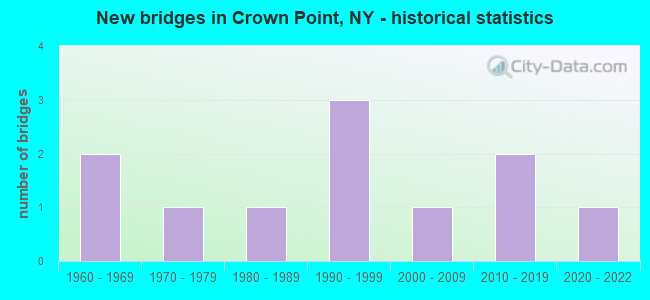
- New bridges - historical statistics
- 21960-1969
- 11970-1979
- 11980-1989
- 31990-1999
- 12000-2009
- 22010-2019
- 12020-2022


- Bridge Condition - Deck
- 18.2%Excellent
- 9.1%Very good
- 45.5%Good
- 18.2%Satisfactory
- 9.1%Fair

- Bridge Condition - Superstructure
- 9.1%Excellent
- 36.4%Very good
- 27.3%Good
- 9.1%Satisfactory
- 18.2%Fair

- Bridge Condition - Substructure
- 27.3%Excellent
- 9.1%Very good
- 27.3%Good
- 36.4%Satisfactory

- Bridge Condition - Channel
- 10.0%Excellent
- 30.0%Very good
- 20.0%Good
- 30.0%Satisfactory
- 10.0%Fair
Find on map >> Show street view
Structure Number: 105005, Location: SOUTH OF CROWN POINT (Lat: 43.997281, Lng: -73.447803), Route carried "on" structure: State highway 185, Year Built: 1982, Status: Open, Structure Length: 8.08m (26.51ft), Average Daily Traffic: 3,006 (year 2020), Truck Traffic: 6%, Average Future Daily Traffic: 3,205 (year 2040), Design Load: HS 20, Features Intersected: DELAWARE & HDSN
Minimum Vertical Clearance: 30+ m (98+ ft), Kilometerpoint: 0.531, Lanes on structure: 2, Base Highway Network: Yes, Owner: State Highway Agency, Approaching Roadway Width: 12.2m (40.0ft), Material/Design: Steel, Design/Construction: Stringer/Multi-beam, Number Of Spans In Main Unit: 3, Length of Maximum Span: 27.1m (88.9ft), Curb-To-Curb Width: 11.3m (37.1ft), Out-to-Out Width: 12.2m (40.0ft)
Condition: Deck: Good, Superstructure: Good, Substructure: Good, Operating Rating: 71.0 metric tons, Method Used To Determine Operating Rating: Load and Resistance Factor Rating (LRFR) rating reported by rating factor(RF) method using HL-93 loadings, Inventory Rating: 54.8 metric tons, Method Used To Determine Inventory Rating: Load and Resistance Factor Rating (LRFR) rating reported by rating factor(RF) method using HL-93 loadings, Structural Evaluation: Better than present minimum criteria, Deck Geometry: Somewhat better than minimum adequacy, Underclear: Equal to present minimum criteria, Approach Roadway Alignment: Equal to present desirable criteria, Length Of Structure Improvement: 8.07m (26.48ft), Designated Inspection Frequency: Every 24 months, Inspection Date: July 2020, Bridge Improvement Cost: $2,135,000, Roadway Improvement Cost: $1,250,000, Total Project Cost: $3,385,000 ( Estimate for 2021), Deck Structure Type: Concrete Cast-file-Place, Wearing Surface/Protective System: Wearing Surface: Integral Concrete, Deck Protection: Epoxy Coated Reinforcing
Find on map >> Show street view
Structure Number: 105356, Location: RT 9N 0.4 MI N CROWN POIN (Lat: 43.956056, Lng: -73.432197), Route carried "on" structure: US 9N, Year Built: 2008, Status: Open, Structure Length: 1.98m (6.50ft), Average Daily Traffic: 2,463 (year 2018), Truck Traffic: 9%, Average Future Daily Traffic: 2,759 (year 2040), Design Load: HL 93, Features Intersected: PUTNAM CREEK
Minimum Vertical Clearance: 30+ m (98+ ft), Kilometerpoint: 21.770, Lanes on structure: 2, Base Highway Network: Yes, Owner: State Highway Agency, Approaching Roadway Width: 9.8m (32.2ft), Skew: 1 degrees, Material/Design: Prestressed concrete, Design/Construction: Box Beam or Girders - Multiple, Number Of Spans In Main Unit: 1, Length of Maximum Span: 18.6m (61.0ft), Curb-To-Curb Width: 9.8m (32.2ft), Out-to-Out Width: 10.8m (35.4ft)
Condition: Deck: Satisfactory, Superstructure: Very good, Substructure: Good, Channel: Satisfactory, Inventory Rating: 61.7 metric tons, Method Used To Determine Inventory Rating: Load Factor (LF), Structural Evaluation: Better than present minimum criteria, Deck Geometry: Meets minimum limits, Waterway Adequacy: Equal to present minimum criteria, Approach Roadway Alignment: Equal to present desirable criteria, Length Of Structure Improvement: 1.98m (6.50ft), Designated Inspection Frequency: Every 24 months, Inspection Date: June 2020, Bridge Improvement Cost: $688,000, Roadway Improvement Cost: $403,000, Total Project Cost: $1,091,000 ( Estimate for 2021), Wearing Surface/Protective System: Wearing Surface: Integral Concrete
Find on map >> Show street view
Structure Number: 330183, Location: ONE MI NE CROWN PT CENTER (Lat: 43.950494, Lng: -73.457950), Route carried "on" structure: County highway , Year Built: 1997, Status: Open, Structure Length: 1.98m (6.50ft), Average Daily Traffic: 378 (year 2018), Truck Traffic: 7%, Average Future Daily Traffic: 529 (year 2038), Design Load: HS 25 or greater, Features Intersected: PUTNAM CREEK, Facility Carried by Structure: CR 2, IRONVILLE RO
Minimum Vertical Clearance: 30+ m (98+ ft), Kilometerpoint: 13.789, Lanes on structure: 2, Owner: County Highway Agency, Approaching Roadway Width: 8.5m (27.9ft), Skew: 3 degrees, Material/Design: Prestressed concrete, Design/Construction: Box Beam or Girders - Multiple, Number Of Spans In Main Unit: 1, Length of Maximum Span: 18.2m (59.7ft), Curb-To-Curb Width: 8.5m (27.9ft), Out-to-Out Width: 10.1m (33.1ft)
Condition: Deck: Satisfactory, Superstructure: Good, Substructure: Good, Channel: Very good, Operating Rating: 88.9 metric tons, Method Used To Determine Operating Rating: Load Factor (LF), Inventory Rating: 43.5 metric tons, Method Used To Determine Inventory Rating: Load Factor (LF), Structural Evaluation: Better than present minimum criteria, Deck Geometry: Equal to present minimum criteria, Waterway Adequacy: Superior to present desirable criteria, Approach Roadway Alignment: Equal to present desirable criteria, Length Of Structure Improvement: 1.98m (6.50ft), Designated Inspection Frequency: Every 24 months, Inspection Date: July 2021, Bridge Improvement Cost: $693,000, Roadway Improvement Cost: $406,000, Total Project Cost: $1,099,000 ( Estimate for 2021), Wearing Surface/Protective System: Wearing Surface: Monolithic Concrete
Find on map >> Show street view
Structure Number: 330184, Location: .25 MI E CROWN POINT CTR (Lat: 43.943178, Lng: -73.463139), Route carried "on" structure: ServiceOther road , Year Built: 1995, Status: Open, Structure Length: 1.71m (5.61ft), Truck Traffic: 10%, Design Load: HS 20, Features Intersected: PUTNAM CREEK, Facility Carried by Structure: FISH HATCHERY RD
Minimum Vertical Clearance: 30+ m (98+ ft), Kilometerpoint: 0.064, Lanes on structure: 1, Owner: County Highway Agency, Approaching Roadway Width: 4.3m (14.1ft), Material/Design: Steel, Design/Construction: Stringer/Multi-beam, Number Of Spans In Main Unit: 1, Length of Maximum Span: 15.8m (51.8ft), Curb-To-Curb Width: 4.3m (14.1ft), Out-to-Out Width: 4.9m (16.1ft)
Condition: Deck: Very good, Superstructure: Very good, Substructure: Very good, Channel: Good, Inventory Rating: 60.8 metric tons, Method Used To Determine Inventory Rating: Load Factor (LF), Structural Evaluation: Equal to present desirable criteria, Deck Geometry: Equal to present minimum criteria, Waterway Adequacy: Superior to present desirable criteria, Approach Roadway Alignment: Equal to present desirable criteria, Length Of Structure Improvement: 1.70m (5.58ft), Designated Inspection Frequency: Every 24 months, Inspection Date: April 2020, Bridge Improvement Cost: $200,000, Roadway Improvement Cost: $117,000, Total Project Cost: $317,000 ( Estimate for 2021), Deck Structure Type: Concrete Cast-file-Place, Wearing Surface/Protective System: Wearing Surface: Integral Concrete, Deck Protection: Epoxy Coated Reinforcing
Find on map >> Show street view
Structure Number: 330185, Location: CROWN POINT (Lat: 43.940958, Lng: -73.470656), Route carried "on" structure: County highway , Year Built: 1978, Status: Open, Structure Length: 1.25m (4.10ft), Average Daily Traffic: 718 (year 2019), Truck Traffic: 4%, Average Future Daily Traffic: 1,005 (year 2039), Design Load: H 20, Features Intersected: PUTNAM CREEK, Facility Carried by Structure: CR 7 BRADFORD HIL
Minimum Vertical Clearance: 30+ m (98+ ft), Kilometerpoint: 6.919, Lanes on structure: 2, Owner: County Highway Agency, Approaching Roadway Width: 7.9m (25.9ft), Material/Design: Steel, Design/Construction: Stringer/Multi-beam, Number Of Spans In Main Unit: 1, Length of Maximum Span: 11.5m (37.7ft), Curb-To-Curb Width: 7.9m (25.9ft), Out-to-Out Width: 8.5m (27.9ft)
Condition: Deck: Fair, Superstructure: Fair, Substructure: Satisfactory, Channel: Satisfactory, Operating Rating: 32.7 metric tons, Method Used To Determine Operating Rating: Load Factor (LF), Inventory Rating: 19.1 metric tons, Method Used To Determine Inventory Rating: Load Factor (LF), Structural Evaluation: Somewhat better than minimum adequacy, Deck Geometry: Somewhat better than minimum adequacy, Waterway Adequacy: Superior to present desirable criteria, Approach Roadway Alignment: Equal to present desirable criteria, Length Of Structure Improvement: 1.24m (4.07ft), Designated Inspection Frequency: Every 24 months, Inspection Date: April 2020, Bridge Improvement Cost: $353,000, Roadway Improvement Cost: $206,000, Total Project Cost: $559,000 ( Estimate for 2021), Deck Structure Type: Wood or Timber, Wearing Surface/Protective System: Wearing Surface: Bituminous
Find on map >> Show street view
Structure Number: 330186, Location: .25 MILE EAST OF IRONVILL (Lat: 43.922603, Lng: -73.531922), Route carried "on" structure: Other road , Year Built: 2020, Status: Open, Structure Length: 1.98m (6.50ft), Average Daily Traffic: 46 (year 2018), Truck Traffic: 6%, Average Future Daily Traffic: 64 (year 2038), Design Load: HL 93, Features Intersected: PUTNAM CREEK, Facility Carried by Structure: PEASLEY ROAD
Minimum Vertical Clearance: 30+ m (98+ ft), Kilometerpoint: 0.177, Lanes on structure: 1, Owner: County Highway Agency, Approaching Roadway Width: 4.3m (14.1ft), Material/Design: Steel, Design/Construction: Stringer/Multi-beam, Number Of Spans In Main Unit: 1, Length of Maximum Span: 19.5m (64.0ft), Curb-To-Curb Width: 4.3m (14.1ft), Out-to-Out Width: 4.6m (15.1ft)
Condition: Deck: Excellent, Superstructure: Excellent, Substructure: Excellent, Channel: Very good, Inventory Rating: 59.9 metric tons, Method Used To Determine Inventory Rating: Load Factor (LF), Structural Evaluation: Superior to present desirable criteria, Deck Geometry: Equal to present minimum criteria, Waterway Adequacy: Better than present minimum criteria, Approach Roadway Alignment: Meets minimum limits, Length Of Structure Improvement: 1.98m (6.50ft), Designated Inspection Frequency: Every 24 months, Critical Feature Inspection Frequency: Every 24 months, Inspection Date: November 2020, Critical Feature Inspection Date: November 2020, Bridge Improvement Cost: $199,000, Roadway Improvement Cost: $117,000, Total Project Cost: $316,000 ( Estimate for 2021), Deck Structure Type: Concrete Cast-file-Place, Wearing Surface/Protective System: Wearing Surface: Integral Concrete
Find on map >> Show street view
Structure Number: 330253, Location: 7MI NW TICONDEROGA (Lat: 43.930656, Lng: -73.510183), Route carried "on" structure: County highway , Year Built: 1961, Status: Open, Structure Length: 1.04m (3.41ft), Average Daily Traffic: 338 (year 2016), Truck Traffic: 7%, Average Future Daily Traffic: 473 (year 2036), Features Intersected: PUTNAM CREEK, Facility Carried by Structure: AMY HILL RD CR 47
Minimum Vertical Clearance: 30+ m (98+ ft), Kilometerpoint: 0.080, Lanes on structure: 2, Owner: County Highway Agency, Approaching Roadway Width: 6.1m (20.0ft), Material/Design: Steel, Design/Construction: Stringer/Multi-beam, Number Of Spans In Main Unit: 1, Length of Maximum Span: 9.1m (29.9ft), Curb-To-Curb Width: 6.1m (20.0ft), Out-to-Out Width: 7.0m (23.0ft)
Condition: Deck: Good, Superstructure: Satisfactory, Substructure: Satisfactory, Channel: Satisfactory, Operating Rating: 48.0 metric tons, Method Used To Determine Operating Rating: Load and Resistance Factor Rating (LRFR) rating reported by rating factor(RF) method using HL-93 loadings, Inventory Rating: 36.9 metric tons, Method Used To Determine Inventory Rating: Load and Resistance Factor Rating (LRFR) rating reported by rating factor(RF) method using HL-93 loadings, Structural Evaluation: Equal to present minimum criteria, Deck Geometry: Meets minimum limits, Waterway Adequacy: Meets minimum limits, Approach Roadway Alignment: Meets minimum limits, Length Of Structure Improvement: 1.03m (3.38ft), Designated Inspection Frequency: Every 24 months, Inspection Date: June 2020, Bridge Improvement Cost: $302,000, Roadway Improvement Cost: $177,000, Total Project Cost: $479,000 ( Estimate for 2021), Deck Structure Type: Concrete Cast-file-Place, Wearing Surface/Protective System: Wearing Surface: Bituminous
Find on map >> Show street view
Structure Number: 330254, Location: 1.5MI W CROWN PT CENTER (Lat: 43.944633, Lng: -73.501714), Route carried "on" structure: Other road , Year Built: 1960, Status: Posted for load, Structure Length: 1.07m (3.51ft), Average Daily Traffic: 265 (year 2018), Truck Traffic: 21%, Average Future Daily Traffic: 371 (year 2038), Features Intersected: PUTNAM CREEK, Facility Carried by Structure: HAMILTON ROAD
Minimum Vertical Clearance: 30+ m (98+ ft), Kilometerpoint: 0.048, Lanes on structure: 2, Owner: County Highway Agency, Approaching Roadway Width: 6.7m (22.0ft), Skew: 2 degrees, Material/Design: Steel, Design/Construction: Stringer/Multi-beam, Number Of Spans In Main Unit: 1, Length of Maximum Span: 9.8m (32.2ft), Curb-To-Curb Width: 6.6m (21.7ft), Out-to-Out Width: 7.0m (23.0ft)
Condition: Deck: Good, Superstructure: Fair, Substructure: Satisfactory, Channel: Fair, Operating Rating: 65.3 metric tons, Method Used To Determine Operating Rating: Load Factor (LF), Inventory Rating: 39.0 metric tons, Method Used To Determine Inventory Rating: Load Factor (LF), Structural Evaluation: Somewhat better than minimum adequacy, Deck Geometry: Meets minimum limits, Waterway Adequacy: Meets minimum limits, Approach Roadway Alignment: Meets minimum limits, Bridge Posting: Required (Relationship of Operating Rating to Maximum Legal Load: > 39.9% below), Length Of Structure Improvement: 1.06m (3.48ft), Designated Inspection Frequency: Every 12 months, Inspection Date: June 2021, Bridge Improvement Cost: $360,000, Roadway Improvement Cost: $211,000, Total Project Cost: $571,000 ( Estimate for 2021), Deck Structure Type: Concrete Cast-file-Place, Wearing Surface/Protective System: Wearing Surface: Bituminous
Find on map >> Show street view
Structure Number: 330255, Location: 1.5 MI W OF CROWN POINT (Lat: 43.944044, Lng: -73.486025), Route carried "on" structure: County highway , Year Built: 1994, Year Reconstructed: 2007, Status: Open, Structure Length: 2.19m (7.19ft), Average Daily Traffic: 378 (year 2018), Truck Traffic: 7%, Average Future Daily Traffic: 529 (year 2038), Design Load: HS 25 or greater, Features Intersected: PUTNAM CREEK, Facility Carried by Structure: CR 2 CREEK ROAD
Minimum Vertical Clearance: 30+ m (98+ ft), Kilometerpoint: 10.909, Lanes on structure: 2, Owner: County Highway Agency, Approaching Roadway Width: 7.9m (25.9ft), Skew: 4 degrees, Material/Design: Steel, Design/Construction: Stringer/Multi-beam, Number Of Spans In Main Unit: 1, Length of Maximum Span: 21.0m (68.9ft), Curb-To-Curb Width: 7.9m (25.9ft), Out-to-Out Width: 8.7m (28.5ft)
Condition: Deck: Good, Superstructure: Good, Substructure: Satisfactory, Channel: Good, Inventory Rating: 70.8 metric tons, Method Used To Determine Inventory Rating: Load Factor (LF), Structural Evaluation: Equal to present minimum criteria, Deck Geometry: Somewhat better than minimum adequacy, Waterway Adequacy: Superior to present desirable criteria, Approach Roadway Alignment: Equal to present desirable criteria, Length Of Structure Improvement: 2.19m (7.19ft), Designated Inspection Frequency: Every 24 months, Inspection Date: April 2020, Bridge Improvement Cost: $525,000, Roadway Improvement Cost: $307,000, Total Project Cost: $832,000 ( Estimate for 2021), Deck Structure Type: Concrete Cast-file-Place, Wearing Surface/Protective System: Wearing Surface: Integral Concrete, Deck Protection: Epoxy Coated Reinforcing
Find on map >> Show street view
Structure Number: 330256, Location: 1 MI W CROWN PT (Lat: 43.942092, Lng: -73.503233), Route carried "on" structure: County highway , Year Built: 2014, Status: Open, Structure Length: 2.32m (7.61ft), Average Daily Traffic: 535 (year 2018), Truck Traffic: 7%, Average Future Daily Traffic: 749 (year 2038), Features Intersected: PUTNAM CREEK, Facility Carried by Structure: CR 2, CREEK RD.
Minimum Vertical Clearance: 30+ m (98+ ft), Kilometerpoint: 9.026, Lanes on structure: 2, Owner: County Highway Agency, Approaching Roadway Width: 7.3m (24.0ft), Skew: 4 degrees, Material/Design: Steel, Design/Construction: Stringer/Multi-beam, Number Of Spans In Main Unit: 1, Length of Maximum Span: 21.6m (70.9ft), Curb-To-Curb Width: 7.3m (24.0ft), Out-to-Out Width: 8.1m (26.6ft)
Condition: Deck: Excellent, Superstructure: Very good, Substructure: Excellent, Channel: Very good, Operating Rating: 88.9 metric tons, Method Used To Determine Operating Rating: Load Factor (LF), Inventory Rating: 52.6 metric tons, Method Used To Determine Inventory Rating: Load Factor (LF), Structural Evaluation: Equal to present desirable criteria, Deck Geometry: Meets minimum limits, Waterway Adequacy: Superior to present desirable criteria, Approach Roadway Alignment: Equal to present minimum criteria, Length Of Structure Improvement: 2.31m (7.58ft), Designated Inspection Frequency: Every 24 months, Inspection Date: September 2020, Bridge Improvement Cost: $708,000, Roadway Improvement Cost: $415,000, Total Project Cost: $1,122,000 ( Estimate for 2021), Deck Structure Type: Concrete Cast-file-Place, Wearing Surface/Protective System: Wearing Surface: Integral Concrete, Deck Protection: Epoxy Coated Reinforcing
Find on map >> Show street view
Structure Number: 552118, Location: 16.2MI NE OF JCT.9N&22&74 (Lat: 44.030164, Lng: -73.425269), Route carried "on" structure: State highway 185, Year Built: 2011, Status: Open, Structure Length: 67.18m (220.41ft), Average Daily Traffic: 3,006 (year 2020), Truck Traffic: 6%, Average Future Daily Traffic: 3,205 (year 2040), Design Load: HL 93, Features Intersected: LAKE CHAMPLAIN
Minimum Vertical Clearance: 7.62m (25.00ft), Kilometerpoint: 6.211, Lanes on structure: 2, Base Highway Network: Yes, Owner: State Highway Agency, Approaching Roadway Width: 9.8m (32.2ft), Navigation Control: Yes ( Vertical Clearance: 22.9m (75.1ft), Horizontal Clearance: 91.4m (299.9ft)), Material/Design: Steel, Design/Construction: Arch - Thru, Number Of Spans In Main Unit: 1, Number Of Approach Spans: 7, Length of Maximum Span: 122.5m (401.9ft), Curb or Sidewalk Widths: Left: 1.5m (4.9ft), Right: 1.5m (4.9ft), Curb-To-Curb Width: 9.8m (32.2ft), Out-to-Out Width: 14.4m (47.2ft)
Condition: Deck: Good, Superstructure: Very good, Substructure: Excellent, Channel: Excellent, Inventory Rating: 40.8 metric tons, Method Used To Determine Inventory Rating: Field evaluation and documented engineering judgment, Structural Evaluation: Equal to present desirable criteria, Deck Geometry: Meets minimum limits, Waterway Adequacy: Equal to present desirable criteria, Approach Roadway Alignment: Better than present minimum criteria, Length Of Structure Improvement: 67.17m (220.37ft), Designated Inspection Frequency: Every 24 months, Critical Feature Inspection Frequency: Every 24 months, Underwater Inspection Frequency: Every 60 months, Inspection Date: October 2021, Critical Feature Inspection Date: October 2021, Underwater Inspection Date: October 2017, Bridge Improvement Cost: $41,808,000, Roadway Improvement Cost: $24,483,000, Total Project Cost: $66,291,000 ( Estimate for 2021), Deck Structure Type: Concrete Cast-file-Place, Wearing Surface/Protective System: Wearing Surface: Integral Concrete, Deck Protection: Epoxy Coated Reinforcing