Bridge Statistics for Croydon, Pennsylvania (PA)
Condition, Traffic, Stress, Structural Evaluation, Project Costs
- National Bridge Inventory (NBI) Statistics
- 24Number of bridges
- 325ft / 98.6mTotal length
- $8,050,000Total costs
- 576,634Total average daily traffic
- 42,031Total average daily truck traffic
- National Bridge Inventory (NBI) Registered Bridges for Croydon
- No street view available for this location
- New bridges - historical statistics
- 11930-1939
- 181960-1969
- 11980-1989
- 41990-1999
- Reconstructed bridges - Historical Statistics
- 11970-1979
- 21980-1989
- 11990-1999
- 02000-2009
- 12010-2019
- Bridge Condition - Deck
- 36.4%Good
- 45.5%Satisfactory
- 18.2%Fair
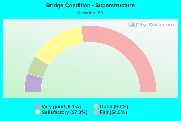
- Bridge Condition - Superstructure
- 9.1%Very good
- 9.1%Good
- 27.3%Satisfactory
- 54.5%Fair
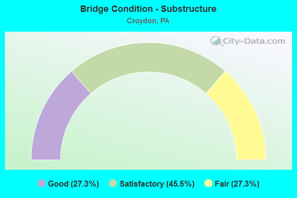
- Bridge Condition - Substructure
- 27.3%Good
- 45.5%Satisfactory
- 27.3%Fair
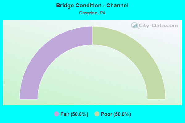
- Bridge Condition - Channel
- 50.0%Fair
- 50.0%Poor
Find on map >> Show street view
Structure Number: 6843, Location: 1MI.N.EDDINGTON 42B12 (Lat: 40.092400, Lng: -74.919972), Route carried "on" structure: Interstate 95, Year Built: 1964, Status: Open, Structure Length: 8.47m (27.79ft), Average Daily Traffic: 44,372 (year 2021), Truck Traffic: 8%, Average Future Daily Traffic: 48,073 (year 2032), Design Load: HS 20+Mod, Features Intersected: BRISTOL PIKE
Minimum Vertical Clearance: 30+ m (98+ ft), Kilometerpoint: 6.442, Lanes on structure: 3, Lanes under structure: 2, Base Highway Network: Yes, Owner: State Highway Agency, Approaching Roadway Width: 17.1m (56.1ft), Skew: 15 degrees, Material/Design: Steel, Design/Construction: Stringer/Multi-beam, Number Of Spans In Main Unit: 1, Number Of Approach Spans: 2, Length of Maximum Span: 40.5m (132.9ft), Curb or Sidewalk Widths: Left: 0.2m (0.7ft), Right: 0.2m (0.7ft), Curb-To-Curb Width: 13.4m (44.0ft), Out-to-Out Width: 15.1m (49.5ft)
Condition: Deck: Fair, Superstructure: Fair, Substructure: Fair, Operating Rating: 76.2 metric tons, Method Used To Determine Operating Rating: Load Factor (LF), Inventory Rating: 45.4 metric tons, Method Used To Determine Inventory Rating: Load Factor (LF), Structural Evaluation: Somewhat better than minimum adequacy, Deck Geometry: Meets minimum limits, Underclear: Equal to present minimum criteria, Approach Roadway Alignment: Equal to present desirable criteria, Length Of Structure Improvement: 9.40m (30.84ft), Designated Inspection Frequency: Every 24 months, Inspection Date: January 2020, Bridge Improvement Cost: $66,000, Roadway Improvement Cost: $195,000, Total Project Cost: $893,000, Deck Structure Type: Concrete Cast-file-Place, Wearing Surface/Protective System: Wearing Surface: Bituminous
Find on map >> Show street view
Structure Number: 6845, Location: 1MI.N.EDDINGTON 42B12 (Lat: 40.092264, Lng: -74.920572), Route carried "on" structure: Interstate 95, Year Built: 1964, Status: Open, Structure Length: 8.93m (29.30ft), Average Daily Traffic: 44,587 (year 2021), Truck Traffic: 7%, Average Future Daily Traffic: 47,759 (year 2032), Design Load: HS 20+Mod, Features Intersected: BRISTOL PIKE
Minimum Vertical Clearance: 30+ m (98+ ft), Kilometerpoint: 6.408, Lanes on structure: 3, Lanes under structure: 2, Base Highway Network: Yes, Owner: State Highway Agency, Approaching Roadway Width: 17.1m (56.1ft), Skew: 15 degrees, Material/Design: Steel, Design/Construction: Stringer/Multi-beam, Number Of Spans In Main Unit: 1, Number Of Approach Spans: 2, Length of Maximum Span: 41.5m (136.2ft), Curb or Sidewalk Widths: Left: 0.2m (0.7ft), Right: 0.2m (0.7ft), Curb-To-Curb Width: 13.4m (44.0ft), Out-to-Out Width: 15.1m (49.5ft)
Condition: Deck: Fair, Superstructure: Fair, Substructure: Fair, Operating Rating: 81.6 metric tons, Method Used To Determine Operating Rating: Load Factor (LF), Inventory Rating: 49.0 metric tons, Method Used To Determine Inventory Rating: Load Factor (LF), Structural Evaluation: Somewhat better than minimum adequacy, Deck Geometry: Meets minimum limits, Underclear: High priority of corrective action, Approach Roadway Alignment: Equal to present desirable criteria, Length Of Structure Improvement: 9.90m (32.48ft), Designated Inspection Frequency: Every 24 months, Inspection Date: January 2020, Bridge Improvement Cost: $70,000, Roadway Improvement Cost: $205,000, Total Project Cost: $940,000, Deck Structure Type: Concrete Cast-file-Place, Wearing Surface/Protective System: Wearing Surface: Bituminous
Find on map >> Show street view
Structure Number: 6846, Location: 1MI.N.EDDINGTON 42B12 (Lat: 40.094744, Lng: -74.918097), Route carried "on" structure: Interstate 95, Year Built: 1964, Year Reconstructed: 2010, Status: Open, Structure Length: 4.42m (14.50ft), Average Daily Traffic: 44,587 (year 2021), Truck Traffic: 7%, Average Future Daily Traffic: 47,759 (year 2032), Design Load: HS 20, Features Intersected: MAPLE AVENUE (T454)
Minimum Vertical Clearance: 30+ m (98+ ft), Kilometerpoint: 6.408, Lanes on structure: 3, Lanes under structure: 2, Base Highway Network: Yes, Owner: State Highway Agency, Approaching Roadway Width: 14.3m (46.9ft), Skew: 14 degrees, Material/Design: Prestressed concrete, Design/Construction: Stringer/Multi-beam, Number Of Spans In Main Unit: 3, Length of Maximum Span: 17.1m (56.1ft), Curb or Sidewalk Widths: Left: 0.5m (1.6ft), Right: 0.5m (1.6ft), Curb-To-Curb Width: 15.8m (51.8ft), Out-to-Out Width: 17.6m (57.7ft)
Condition: Deck: Good, Superstructure: Fair, Substructure: Satisfactory, Operating Rating: 61.7 metric tons, Method Used To Determine Operating Rating: Load Factor (LF), Inventory Rating: 26.3 metric tons, Method Used To Determine Inventory Rating: Load Factor (LF), Structural Evaluation: Somewhat better than minimum adequacy, Deck Geometry: Somewhat better than minimum adequacy, Underclear: Somewhat better than minimum adequacy, Approach Roadway Alignment: Equal to present desirable criteria, Length Of Structure Improvement: 4.40m (14.44ft), Designated Inspection Frequency: Every 24 months, Inspection Date: December 2019, Bridge Improvement Cost: $84,000, Roadway Improvement Cost: $429,000, Total Project Cost: $1,137,000, Deck Structure Type: Concrete Cast-file-Place, Wearing Surface/Protective System: Wearing Surface: Bituminous, Deck Protection: Epoxy Coated Reinforcing
Find on map >> Show street view
Structure Number: 6849, Location: 1MI.S.CROYDON 42D11 (Lat: 40.101786, Lng: -74.908156), Route carried "on" structure: Interstate 95, Year Built: 1964, Year Reconstructed: 1980, Status: Open, Structure Length: 1.01m (3.31ft), Average Daily Traffic: 44,372 (year 2021), Truck Traffic: 8%, Average Future Daily Traffic: 48,073 (year 2032), Design Load: HS 20+Mod, Features Intersected: KLECKNER ROAD
Minimum Vertical Clearance: 30+ m (98+ ft), Kilometerpoint: 8.055, Lanes on structure: 3, Lanes under structure: 2, Base Highway Network: Yes, Owner: State Highway Agency, Approaching Roadway Width: 15.5m (50.9ft), Skew: 10 degrees, Material/Design: Concrete, Design/Construction: Frame, Number Of Spans In Main Unit: 1, Length of Maximum Span: 9.1m (29.9ft), Curb or Sidewalk Widths: Left: 0.2m (0.7ft), Right: 0.2m (0.7ft), Curb-To-Curb Width: 16.2m (53.1ft), Out-to-Out Width: 17.9m (58.7ft)
Condition: Deck: Satisfactory, Superstructure: Satisfactory, Substructure: Satisfactory, Operating Rating: 53.5 metric tons, Method Used To Determine Operating Rating: Load Factor (LF), Inventory Rating: 31.8 metric tons, Method Used To Determine Inventory Rating: Load Factor (LF), Structural Evaluation: Equal to present minimum criteria, Deck Geometry: Equal to present minimum criteria, Underclear: High priority of corrective action, Approach Roadway Alignment: Equal to present desirable criteria, Length Of Structure Improvement: 1.60m (5.25ft), Designated Inspection Frequency: Every 24 months, Inspection Date: January 2020, Deck Structure Type: Concrete Cast-file-Place, Wearing Surface/Protective System: Wearing Surface: Bituminous
Find on map >> Show street view
Structure Number: 685, Location: 1MI.S.CROYDON 42D11 (Lat: 40.101983, Lng: -74.908381), Route carried "on" structure: Interstate 95, Year Built: 1964, Year Reconstructed: 1981, Status: Open, Structure Length: 1.04m (3.41ft), Average Daily Traffic: 44,587 (year 2021), Truck Traffic: 7%, Average Future Daily Traffic: 47,759 (year 2032), Design Load: HS 20+Mod, Features Intersected: KLECKNER ROAD
Minimum Vertical Clearance: 30+ m (98+ ft), Kilometerpoint: 8.018, Lanes on structure: 3, Lanes under structure: 2, Base Highway Network: Yes, Owner: State Highway Agency, Approaching Roadway Width: 15.5m (50.9ft), Skew: 10 degrees, Material/Design: Concrete, Design/Construction: Frame, Number Of Spans In Main Unit: 1, Length of Maximum Span: 9.1m (29.9ft), Curb or Sidewalk Widths: Left: 0.2m (0.7ft), Right: 0.2m (0.7ft), Curb-To-Curb Width: 16.2m (53.1ft), Out-to-Out Width: 17.5m (57.4ft)
Condition: Deck: Satisfactory, Superstructure: Satisfactory, Substructure: Satisfactory, Operating Rating: 53.5 metric tons, Method Used To Determine Operating Rating: Load Factor (LF), Inventory Rating: 31.8 metric tons, Method Used To Determine Inventory Rating: Load Factor (LF), Structural Evaluation: Equal to present minimum criteria, Deck Geometry: Equal to present minimum criteria, Underclear: High priority of corrective action, Approach Roadway Alignment: Equal to present desirable criteria, Length Of Structure Improvement: 1.60m (5.25ft), Designated Inspection Frequency: Every 24 months, Inspection Date: January 2020, Deck Structure Type: Concrete Cast-file-Place, Wearing Surface/Protective System: Wearing Surface: Bituminous
Find on map >> Show street view
Structure Number: 6851, Location: CROYDON 42E10 (Lat: 40.104242, Lng: -74.902072), Route carried "on" structure: Interstate 95, Year Built: 1964, Status: Open, Structure Length: 18.14m (59.51ft), Average Daily Traffic: 44,372 (year 2021), Truck Traffic: 8%, Average Future Daily Traffic: 48,073 (year 2032), Design Load: HS 20+Mod, Features Intersected: NESHAMINY CR & SR 2027
Minimum Vertical Clearance: 30+ m (98+ ft), Kilometerpoint: 8.771, Lanes on structure: 3, Lanes under structure: 2, Base Highway Network: Yes, Owner: State Highway Agency, Approaching Roadway Width: 14.0m (45.9ft), Skew: 12 degrees, Material/Design: Prestressed concrete, Design/Construction: Stringer/Multi-beam, Number Of Spans In Main Unit: 7, Number Of Approach Spans: 1, Length of Maximum Span: 26.5m (86.9ft), Curb or Sidewalk Widths: Left: 0.2m (0.7ft), Right: 0.2m (0.7ft), Curb-To-Curb Width: 13.4m (44.0ft), Out-to-Out Width: 15.1m (49.5ft)
Condition: Deck: Satisfactory, Superstructure: Fair, Substructure: Satisfactory, Channel: Poor, Operating Rating: 61.7 metric tons, Method Used To Determine Operating Rating: Load Factor (LF), Inventory Rating: 21.8 metric tons, Method Used To Determine Inventory Rating: Load Factor (LF), Structural Evaluation: Somewhat better than minimum adequacy, Deck Geometry: Meets minimum limits, Underclear: High priority of corrective action, Waterway Adequacy: Superior to present desirable criteria, Approach Roadway Alignment: Equal to present desirable criteria, Length Of Structure Improvement: 18.10m (59.38ft), Designated Inspection Frequency: Every 24 months, Inspection Date: Febuary 2020, Bridge Improvement Cost: $179,000, Roadway Improvement Cost: $527,000, Total Project Cost: $2,417,000, Deck Structure Type: Concrete Cast-file-Place, Wearing Surface/Protective System: Wearing Surface: Monolithic Concrete, Deck Protection: Epoxy Coated Reinforcing
Find on map >> Show street view
Structure Number: 6854, Location: CROYDON 42E10 (Lat: 40.104622, Lng: -74.901661), Route carried "on" structure: Interstate 95, Year Built: 1964, Status: Open, Structure Length: 18.14m (59.51ft), Average Daily Traffic: 44,587 (year 2021), Truck Traffic: 7%, Average Future Daily Traffic: 47,759 (year 2032), Design Load: HS 20+Mod, Features Intersected: NESHAMINY CR & APPL 276
Minimum Vertical Clearance: 30+ m (98+ ft), Kilometerpoint: 8.798, Lanes on structure: 3, Lanes under structure: 2, Base Highway Network: Yes, Owner: State Highway Agency, Approaching Roadway Width: 14.0m (45.9ft), Skew: 12 degrees, Material/Design: Prestressed concrete, Design/Construction: Stringer/Multi-beam, Number Of Spans In Main Unit: 7, Number Of Approach Spans: 1, Length of Maximum Span: 26.5m (86.9ft), Curb or Sidewalk Widths: Left: 0.2m (0.7ft), Right: 0.2m (0.7ft), Curb-To-Curb Width: 13.4m (44.0ft), Out-to-Out Width: 15.1m (49.5ft)
Condition: Deck: Good, Superstructure: Fair, Substructure: Good, Channel: Poor, Operating Rating: 61.7 metric tons, Method Used To Determine Operating Rating: Load Factor (LF), Inventory Rating: 21.8 metric tons, Method Used To Determine Inventory Rating: Load Factor (LF), Structural Evaluation: Somewhat better than minimum adequacy, Deck Geometry: Meets minimum limits, Underclear: Equal to present minimum criteria, Waterway Adequacy: Superior to present desirable criteria, Approach Roadway Alignment: Equal to present desirable criteria, Length Of Structure Improvement: 18.10m (59.38ft), Designated Inspection Frequency: Every 24 months, Inspection Date: Febuary 2020, Bridge Improvement Cost: $179,000, Roadway Improvement Cost: $527,000, Total Project Cost: $2,417,000, Deck Structure Type: Concrete Cast-file-Place, Wearing Surface/Protective System: Wearing Surface: Monolithic Concrete, Deck Protection: Epoxy Coated Reinforcing
Find on map >> Show street view
Structure Number: 7156, Location: 2MI.TO BRISTOL 46C01 (Lat: 40.084803, Lng: -74.911117), Route carried "on" structure: State highway , Year Built: 1939, Year Reconstructed: 1980, Status: Open, Structure Length: 9.60m (31.50ft), Average Daily Traffic: 9,139 (year 2020), Truck Traffic: 8%, Average Future Daily Traffic: 14,547 (year 2032), Design Load: HS 20, Features Intersected: NESHAMINY CREEK, Facility Carried by Structure: STATE ROAD
Minimum Vertical Clearance: 30+ m (98+ ft), Kilometerpoint: 6.870, Lanes on structure: 2, Owner: State Highway Agency, Approaching Roadway Width: 7.9m (25.9ft), Material/Design: Steel, Design/Construction: Girder and Floorbeam System, Number Of Spans In Main Unit: 3, Length of Maximum Span: 31.1m (102.0ft), Curb or Sidewalk Widths: Left: 1.6m (5.2ft), Right: 0.2m (0.7ft), Curb-To-Curb Width: 7.0m (23.0ft), Out-to-Out Width: 8.2m (26.9ft)
Condition: Deck: Satisfactory, Superstructure: Fair, Substructure: Fair, Channel: Fair, Operating Rating: 75.3 metric tons, Method Used To Determine Operating Rating: Load Factor (LF), Inventory Rating: 44.5 metric tons, Method Used To Determine Inventory Rating: Load Factor (LF), Structural Evaluation: Somewhat better than minimum adequacy, Deck Geometry: High priority of replacement, Waterway Adequacy: Equal to present minimum criteria, Approach Roadway Alignment: Better than present minimum criteria, Length Of Structure Improvement: 10.60m (34.78ft), Designated Inspection Frequency: Every 24 months, Critical Feature Inspection Frequency: Every 24 months, Underwater Inspection Frequency: Every 60 months, Inspection Date: August 2020, Critical Feature Inspection Date: August 2020, Underwater Inspection Date: November 2016, Bridge Improvement Cost: $18,000, Roadway Improvement Cost: $54,000, Total Project Cost: $246,000, Deck Structure Type: Concrete Cast-file-Place, Wearing Surface/Protective System: Wearing Surface: Monolithic Concrete, Deck Protection: Epoxy Coated Reinforcing
Find on map >> Show street view
Structure Number: 7167, Location: .2MI.N.STATE ROAD 46C01 (Lat: 40.086575, Lng: -74.915328), Route carried "on" structure: State highway , Year Built: 1985, Status: Open, Structure Length: 0.94m (3.08ft), Average Daily Traffic: 1,577 (year 2020), Truck Traffic: 6%, Average Future Daily Traffic: 2,809 (year 2032), Design Load: HS 25 or greater, Features Intersected: BR.NESHAMINY CREEK, Facility Carried by Structure: TOTEM ROAD
Minimum Vertical Clearance: 30+ m (98+ ft), Kilometerpoint: 0.389, Lanes on structure: 2, Owner: State Highway Agency, Approaching Roadway Width: 10.4m (34.1ft), Material/Design: Concrete, Design/Construction: Channel Beam, Number Of Spans In Main Unit: 1, Length of Maximum Span: 9.1m (29.9ft), Curb-To-Curb Width: 10.1m (33.1ft), Out-to-Out Width: 11.1m (36.4ft)
Condition: Deck: Satisfactory, Superstructure: Satisfactory, Substructure: Good, Channel: Fair, Inventory Rating: 79.8 metric tons, Method Used To Determine Inventory Rating: Load Factor (LF), Structural Evaluation: Equal to present minimum criteria, Deck Geometry: Somewhat better than minimum adequacy, Waterway Adequacy: Equal to present minimum criteria, Approach Roadway Alignment: Equal to present desirable criteria, Length Of Structure Improvement: 1.60m (5.25ft), Designated Inspection Frequency: Every 24 months, Inspection Date: March 2020, Deck Structure Type: Concrete Cast-file-Place, Wearing Surface/Protective System: Wearing Surface: Monolithic Concrete, Deck Protection: Epoxy Coated Reinforcing
Find on map >> Show street view
Structure Number: 7765, Location: BRISTOL INTERCH. 42F09 (Lat: 40.110472, Lng: -74.891361), Route carried "on" structure: Ramp State highway , Year Built: 1969, Year Reconstructed: 1998, Status: Open, Structure Length: 13.75m (45.11ft), Average Daily Traffic: 9,432 (year 2021), Truck Traffic: 7%, Average Future Daily Traffic: 18,114 (year 2032), Design Load: HS 20, Features Intersected: INTERSTATE 95, Facility Carried by Structure: RAMP A SOUTHBOUND
Minimum Vertical Clearance: 30+ m (98+ ft), Kilometerpoint: 0.000, Lanes on structure: 2, Lanes under structure: 4, Base Highway Network: Yes, Owner: State Highway Agency, Approaching Roadway Width: 12.2m (40.0ft), Skew: 5 degrees, Material/Design: Steel continuous, Design/Construction: Stringer/Multi-beam, Number Of Spans In Main Unit: 2, Number Of Approach Spans: 2, Length of Maximum Span: 47.9m (157.2ft), Curb or Sidewalk Widths: Left: 0.2m (0.7ft), Right: 0.2m (0.7ft), Curb-To-Curb Width: 12.2m (40.0ft), Out-to-Out Width: 13.4m (44.0ft)
Condition: Deck: Good, Superstructure: Good, Substructure: Satisfactory, Operating Rating: 59.9 metric tons, Method Used To Determine Operating Rating: Load Factor (LF), Inventory Rating: 36.3 metric tons, Method Used To Determine Inventory Rating: Load Factor (LF), Structural Evaluation: Equal to present minimum criteria, Deck Geometry: Superior to present desirable criteria, Underclear: Somewhat better than minimum adequacy, Approach Roadway Alignment: Equal to present desirable criteria, Length Of Structure Improvement: 14.50m (47.57ft), Designated Inspection Frequency: Every 24 months, Inspection Date: January 2020, Deck Structure Type: Concrete Cast-file-Place, Wearing Surface/Protective System: Wearing Surface: Latex Concrete
Find on map >> Show street view
Structure Number: 40186, Location: KEYSTONE INDST.PK. 42F09 (Lat: 40.109758, Lng: -74.892461), Route carried "on" structure: Ramp State highway , Year Built: 1999, Status: Open, Structure Length: 14.17m (46.49ft), Average Daily Traffic: 4,784 (year 2021), Truck Traffic: 6%, Average Future Daily Traffic: 6,581 (year 2032), Design Load: HS 25 or greater, Features Intersected: RAMP A;INTERSTATE 95, Facility Carried by Structure: RAMP D
Minimum Vertical Clearance: 30+ m (98+ ft), Kilometerpoint: 0.000, Lanes on structure: 1, Lanes under structure: 6, Base Highway Network: Yes, Owner: State Highway Agency, Approaching Roadway Width: 9.4m (30.8ft), Skew: 2 degrees, Material/Design: Steel continuous, Design/Construction: Stringer/Multi-beam, Number Of Spans In Main Unit: 3, Length of Maximum Span: 50.6m (166.0ft), Curb or Sidewalk Widths: Left: 0.2m (0.7ft), Right: 0.2m (0.7ft), Curb-To-Curb Width: 9.4m (30.8ft), Out-to-Out Width: 10.5m (34.4ft)
Condition: Deck: Good, Superstructure: Very good, Substructure: Good, Operating Rating: 82.6 metric tons, Method Used To Determine Operating Rating: Load Factor (LF), Inventory Rating: 49.0 metric tons, Method Used To Determine Inventory Rating: Load Factor (LF), Structural Evaluation: Better than present minimum criteria, Deck Geometry: Superior to present desirable criteria, Underclear: Equal to present minimum criteria, Approach Roadway Alignment: Somewhat better than minimum adequacy, Length Of Structure Improvement: 15.10m (49.54ft), Designated Inspection Frequency: Every 24 months, Inspection Date: July 2021, Deck Structure Type: Concrete Cast-file-Place, Wearing Surface/Protective System: Wearing Surface: Monolithic Concrete, Deck Protection: Epoxy Coated Reinforcing
Find on map >> Show street view
Structure Number: 6843, Location: 1MI.N.EDDINGTON 42B12 (Lat: 40.092400, Lng: -74.919972), Route carried "under" structure: US 13, Year Built: 1964, Structure Length: 0. m, Average Daily Traffic: 15,097 (year 2021), Truck Traffic: 7%, Features Intersected: BRISTOL PIKE, Facility Carried by Structure: INTERSTATE 95 (NB)
Minimum Vertical Clearance: 4.72m (15.49ft), Kilometerpoint: 5.813, Lanes on structure: 3, Lanes under structure: 2, Material/Design: Steel, Design/Construction: Stringer/Multi-beam, Length of Maximum Span: 40.5m (132.9ft)
Find on map >> Show street view
Structure Number: 6844, Location: 1MI.N.EDDINGTON 42B12 (Lat: 40.094378, Lng: -74.918017), Route carried "under" structure: State highway , Year Built: 1964, Structure Length: 0. m, Average Daily Traffic: 850 (year 1980), Truck Traffic: 7%, Features Intersected: MAPLE AVENUE (T454), Facility Carried by Structure: INTERSTATE 95 (NB)
Minimum Vertical Clearance: 4.49m (14.73ft), Kilometerpoint: 0.000, Lanes on structure: 3, Lanes under structure: 2, Material/Design: Prestressed concrete, Design/Construction: Stringer/Multi-beam, Length of Maximum Span: 17.1m (56.1ft)
Find on map >> Show street view
Structure Number: 6845, Location: 1MI.N.EDDINGTON 42B12 (Lat: 40.092264, Lng: -74.920572), Route carried "under" structure: US 13, Year Built: 1964, Structure Length: 0. m, Average Daily Traffic: 15,097 (year 2021), Truck Traffic: 7%, Features Intersected: BRISTOL PIKE, Facility Carried by Structure: INTERSTATE 95 (SB)
Minimum Vertical Clearance: 4.40m (14.44ft), Kilometerpoint: 5.813, Lanes on structure: 3, Lanes under structure: 2, Material/Design: Steel, Design/Construction: Stringer/Multi-beam, Length of Maximum Span: 41.5m (136.2ft)
Find on map >> Show street view
Structure Number: 6846, Location: 1MI.N.EDDINGTON 42B12 (Lat: 40.094744, Lng: -74.918097), Route carried "under" structure: State highway , Year Built: 1964, Structure Length: 0. m, Average Daily Traffic: 850 (year 1980), Truck Traffic: 7%, Features Intersected: MAPLE AVENUE (T454), Facility Carried by Structure: INTERSTATE 95 (SB)
Minimum Vertical Clearance: 4.42m (14.50ft), Kilometerpoint: 0.000, Lanes on structure: 3, Lanes under structure: 2, Material/Design: Prestressed concrete, Design/Construction: Stringer/Multi-beam, Length of Maximum Span: 17.1m (56.1ft)
Find on map >> Show street view
Structure Number: 6849, Location: 1MI.S.CROYDON 42D11 (Lat: 40.101786, Lng: -74.908156), Route carried "under" structure: State highway , Year Built: 1964, Structure Length: 0. m, Average Daily Traffic: 1,000 (year 1980), Truck Traffic: 7%, Features Intersected: KLECKNER ROAD, Facility Carried by Structure: INTERSTATE 95 (NB)
Minimum Vertical Clearance: 4.40m (14.44ft), Kilometerpoint: 0.000, Lanes on structure: 3, Lanes under structure: 2, Material/Design: Concrete, Design/Construction: Frame, Length of Maximum Span: 9.1m (29.9ft)
Find on map >> Show street view
Structure Number: 685, Location: 1MI.S.CROYDON 42D11 (Lat: 40.101983, Lng: -74.908381), Route carried "under" structure: State highway , Year Built: 1964, Structure Length: 0. m, Average Daily Traffic: 1,000 (year 1980), Truck Traffic: 7%, Features Intersected: KLECKNER ROAD, Facility Carried by Structure: INTERSTATE 95 (SB)
Minimum Vertical Clearance: 4.19m (13.75ft), Kilometerpoint: 0.000, Lanes on structure: 3, Lanes under structure: 2, Material/Design: Concrete, Design/Construction: Frame, Length of Maximum Span: 9.1m (29.9ft)
Find on map >> Show street view
Structure Number: 6851, Location: CROYDON 42E10 (Lat: 40.104242, Lng: -74.902072), Route carried "under" structure: State highway , Year Built: 1964, Structure Length: 0. m, Average Daily Traffic: 9,497 (year 2022), Truck Traffic: 4%, Features Intersected: NESHAMINY CR & SR 2027, Facility Carried by Structure: INTERSTATE 95 (NB)
Minimum Vertical Clearance: 4.15m (13.62ft), Kilometerpoint: 0.922, Lanes on structure: 3, Lanes under structure: 2, Material/Design: Prestressed concrete, Design/Construction: Stringer/Multi-beam, Length of Maximum Span: 26.5m (86.9ft)
Find on map >> Show street view
Structure Number: 6854, Location: CROYDON 42E10 (Lat: 40.104622, Lng: -74.901661), Route carried "under" structure: State highway , Year Built: 1964, Structure Length: 0. m, Average Daily Traffic: 9,497 (year 2022), Truck Traffic: 4%, Features Intersected: NESHAMINY CR & APPL 276, Facility Carried by Structure: INTERSTATE 95 (SB)
Minimum Vertical Clearance: 4.69m (15.39ft), Kilometerpoint: 0.922, Lanes on structure: 3, Lanes under structure: 2, Material/Design: Prestressed concrete, Design/Construction: Stringer/Multi-beam, Length of Maximum Span: 26.5m (86.9ft)
Find on map >> Show street view
Structure Number: 7765, Location: BRISTOL INTERCH. 42F09 (Lat: 40.110472, Lng: -74.891361), Route carried "under" structure: Interstate 95, Year Built: 1969, Structure Length: 0. m, Average Daily Traffic: 44,372 (year 2021), Truck Traffic: 8%, Features Intersected: INTERSTATE 95, Facility Carried by Structure: RAMP A SOUTHBOUND
Minimum Vertical Clearance: 5.08m (16.67ft), Kilometerpoint: 9.637, Lanes on structure: 2, Lanes under structure: 2, Material/Design: Steel continuous, Design/Construction: Stringer/Multi-beam, Length of Maximum Span: 47.9m (157.2ft)
Find on map >> Show street view
Structure Number: 7765, Location: BRISTOL INTERCH. 42F09 (Lat: 40.110472, Lng: -74.891361), Route carried "under" structure: Interstate 95, Year Built: 1969, Structure Length: 0. m, Average Daily Traffic: 44,587 (year 2021), Truck Traffic: 7%, Features Intersected: INTERSTATE 95, Facility Carried by Structure: RAMP A SOUTHBOUND
Minimum Vertical Clearance: 4.93m (16.17ft), Kilometerpoint: 9.643, Lanes on structure: 2, Lanes under structure: 2, Material/Design: Steel continuous, Design/Construction: Stringer/Multi-beam, Length of Maximum Span: 47.9m (157.2ft)
Find on map >> Show street view
Structure Number: 40186, Location: KEYSTONE INDST.PK. 42F09 (Lat: 40.109758, Lng: -74.892461), Route carried "under" structure: Interstate 95, Year Built: 1999, Structure Length: 0. m, Average Daily Traffic: 44,372 (year 2021), Truck Traffic: 8%, Features Intersected: RAMP A;INTERSTATE 95, Facility Carried by Structure: RAMP D
Minimum Vertical Clearance: 7.56m (24.80ft), Kilometerpoint: 9.637, Lanes on structure: 1, Lanes under structure: 2, Material/Design: Steel continuous, Design/Construction: Stringer/Multi-beam, Length of Maximum Span: 50.6m (166.0ft)
Find on map >> Show street view
Structure Number: 40186, Location: KEYSTONE INDST.PK. 42F09 (Lat: 40.109758, Lng: -74.892461), Route carried "under" structure: Ramp State highway , Year Built: 1999, Structure Length: 0. m, Average Daily Traffic: 9,432 (year 2021), Truck Traffic: 7%, Features Intersected: RAMP A;INTERSTATE 95, Facility Carried by Structure: RAMP D
Minimum Vertical Clearance: 5.57m (18.27ft), Kilometerpoint: 0.000, Lanes on structure: 1, Lanes under structure: 2, Material/Design: Steel continuous, Design/Construction: Stringer/Multi-beam, Length of Maximum Span: 50.6m (166.0ft)
Find on map >> Show street view
Structure Number: 40186, Location: KEYSTONE INDST.PK. 42F09 (Lat: 40.109758, Lng: -74.892461), Route carried "under" structure: Interstate 95, Year Built: 1999, Structure Length: 0. m, Average Daily Traffic: 44,587 (year 2021), Truck Traffic: 7%, Features Intersected: RAMP A;INTERSTATE 95, Facility Carried by Structure: RAMP D
Minimum Vertical Clearance: 9.14m (29.99ft), Kilometerpoint: 9.643, Lanes on structure: 1, Lanes under structure: 2, Material/Design: Steel continuous, Design/Construction: Stringer/Multi-beam, Length of Maximum Span: 50.6m (166.0ft)