Bridge Statistics for Crystal City, Missouri (MO)
Condition, Traffic, Stress, Structural Evaluation, Project Costs
- National Bridge Inventory (NBI) Statistics
- 16Number of bridges
- 164ft / 49.7mTotal length
- $3,092,000Total costs
- 124,960Total average daily traffic
- 24,978Total average daily truck traffic
- National Bridge Inventory (NBI) Registered Bridges for Crystal City
- No street view available for this location
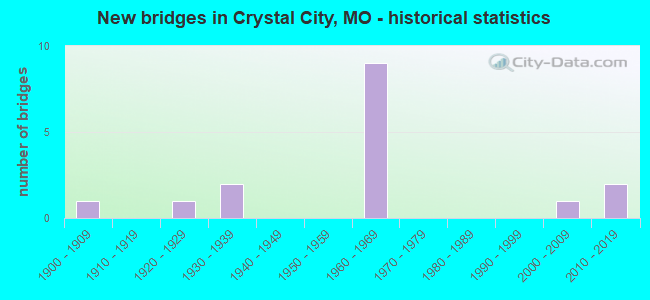
- New bridges - historical statistics
- 11900-1909
- 11920-1929
- 21930-1939
- 91960-1969
- 12000-2009
- 22010-2019

- Reconstructed bridges - Historical Statistics
- 11940-1949
- 01950-1959
- 01960-1969
- 21970-1979
- 11980-1989
- 01990-1999
- 22000-2009


- Bridge Condition - Deck
- 60.0%Good
- 30.0%Satisfactory
- 10.0%Poor

- Bridge Condition - Superstructure
- 10.0%Very good
- 80.0%Good
- 10.0%Poor

- Bridge Condition - Substructure
- 60.0%Good
- 30.0%Satisfactory
- 10.0%Poor

- Bridge Condition - Channel
- 20.0%Good
- 60.0%Satisfactory
- 20.0%Poor
Find on map >> Show street view
Structure Number: 1902, Location: S 1916 T 40 N R 6 E (Lat: 38.185100, Lng: -90.388658), Route carried "on" structure: Interstate 55, Year Built: 1969, Status: Open, Structure Length: 5.67m (18.60ft), Average Daily Traffic: 12,970 (year 2021), Truck Traffic: 22%, Average Future Daily Traffic: 23,995 (year 2041), Design Load: HS 20+Mod, Features Intersected: UNKNOWN RR
Minimum Vertical Clearance: 30+ m (98+ ft), Kilometerpoint: 58.274, Lanes on structure: 2, Base Highway Network: Yes, Owner: State Highway Agency, Approaching Roadway Width: 11.6m (38.1ft), Skew: 4 degrees, Material/Design: Steel continuous, Design/Construction: Stringer/Multi-beam, Number Of Spans In Main Unit: 3, Length of Maximum Span: 22.3m (73.2ft), Curb-To-Curb Width: 11.6m (38.1ft), Out-to-Out Width: 12.4m (40.7ft)
Condition: Deck: Good, Superstructure: Good, Substructure: Satisfactory, Operating Rating: 60.3 metric tons, Method Used To Determine Operating Rating: Load Factor (LF), Inventory Rating: 36.0 metric tons, Method Used To Determine Inventory Rating: Load Factor (LF), Structural Evaluation: Equal to present minimum criteria, Deck Geometry: Equal to present minimum criteria, Underclear: Superior to present desirable criteria, Approach Roadway Alignment: Equal to present desirable criteria, Designated Inspection Frequency: Every 24 months, Inspection Date: November 2020, Deck Structure Type: Concrete Cast-file-Place, Wearing Surface/Protective System: Wearing Surface: Latex Concrete, Membrane: Built-up
Find on map >> Show street view
Structure Number: 1903, Location: S 1916 T 40 N R 6 E (Lat: 38.185433, Lng: -90.388608), Route carried "on" structure: Interstate 55, Year Built: 1969, Status: Open, Structure Length: 5.85m (19.19ft), Average Daily Traffic: 13,069 (year 2021), Truck Traffic: 27%, Average Future Daily Traffic: 24,178 (year 2041), Design Load: HS 20+Mod, Features Intersected: UNKNOWN RR
Minimum Vertical Clearance: 30+ m (98+ ft), Kilometerpoint: 279.413, Lanes on structure: 2, Base Highway Network: Yes, Owner: State Highway Agency, Approaching Roadway Width: 11.6m (38.1ft), Skew: 4 degrees, Material/Design: Steel continuous, Design/Construction: Stringer/Multi-beam, Number Of Spans In Main Unit: 3, Length of Maximum Span: 22.3m (73.2ft), Curb-To-Curb Width: 11.6m (38.1ft), Out-to-Out Width: 12.4m (40.7ft)
Condition: Deck: Good, Superstructure: Very good, Substructure: Good, Operating Rating: 61.2 metric tons, Method Used To Determine Operating Rating: Load Factor (LF), Inventory Rating: 36.9 metric tons, Method Used To Determine Inventory Rating: Load Factor (LF), Structural Evaluation: Better than present minimum criteria, Deck Geometry: Equal to present minimum criteria, Underclear: Superior to present desirable criteria, Approach Roadway Alignment: Equal to present desirable criteria, Designated Inspection Frequency: Every 24 months, Inspection Date: November 2020, Deck Structure Type: Concrete Cast-file-Place, Wearing Surface/Protective System: Wearing Surface: Latex Concrete, Membrane: Built-up
Find on map >> Show street view
Structure Number: 1904, Location: S 1915 T 40 N R 6 E (Lat: 38.181558, Lng: -90.384294), Route carried "on" structure: Interstate 55, Year Built: 1969, Year Reconstructed: 1984, Status: Open, Structure Length: 7.07m (23.20ft), Average Daily Traffic: 13,069 (year 2021), Truck Traffic: 27%, Average Future Daily Traffic: 24,178 (year 2041), Design Load: HS 20+Mod, Features Intersected: PLATTIN CR
Minimum Vertical Clearance: 30+ m (98+ ft), Kilometerpoint: 278.839, Lanes on structure: 2, Base Highway Network: Yes, Owner: State Highway Agency, Approaching Roadway Width: 11.6m (38.1ft), Material/Design: Steel continuous, Design/Construction: Stringer/Multi-beam, Number Of Spans In Main Unit: 3, Length of Maximum Span: 27.4m (89.9ft), Curb-To-Curb Width: 11.6m (38.1ft), Out-to-Out Width: 12.5m (41.0ft)
Condition: Deck: Satisfactory, Superstructure: Good, Substructure: Good, Channel: Good, Operating Rating: 57.6 metric tons, Method Used To Determine Operating Rating: Load Factor (LF), Inventory Rating: 34.2 metric tons, Method Used To Determine Inventory Rating: Load Factor (LF), Structural Evaluation: Better than present minimum criteria, Deck Geometry: Equal to present minimum criteria, Waterway Adequacy: Equal to present desirable criteria, Approach Roadway Alignment: Equal to present desirable criteria, Designated Inspection Frequency: Every 24 months, Inspection Date: November 2020, Deck Structure Type: Concrete Cast-file-Place, Wearing Surface/Protective System: Wearing Surface: Latex Concrete, Membrane: Built-up
Find on map >> Show street view
Structure Number: 1906, Location: S 28 T 40 N R 6 E (Lat: 38.157983, Lng: -90.357922), Route carried "on" structure: Interstate 55, Year Built: 1969, Year Reconstructed: 2009, Status: Open, Structure Length: 4.54m (14.90ft), Average Daily Traffic: 13,165 (year 2021), Truck Traffic: 22%, Average Future Daily Traffic: 24,355 (year 2041), Design Load: HS 20+Mod, Features Intersected: US 61
Minimum Vertical Clearance: 30+ m (98+ ft), Kilometerpoint: 62.341, Lanes on structure: 2, Lanes under structure: 2, Base Highway Network: Yes, Owner: State Highway Agency, Approaching Roadway Width: 11.6m (38.1ft), Skew: 3 degrees, Material/Design: Steel continuous, Design/Construction: Stringer/Multi-beam, Number Of Spans In Main Unit: 3, Length of Maximum Span: 18.0m (59.1ft), Curb-To-Curb Width: 11.6m (38.1ft), Out-to-Out Width: 12.4m (40.7ft)
Condition: Deck: Satisfactory, Superstructure: Good, Substructure: Satisfactory, Operating Rating: 56.7 metric tons, Method Used To Determine Operating Rating: Load Factor (LF), Inventory Rating: 34.2 metric tons, Method Used To Determine Inventory Rating: Load Factor (LF), Structural Evaluation: Equal to present minimum criteria, Deck Geometry: Equal to present minimum criteria, Underclear: Superior to present desirable criteria, Approach Roadway Alignment: Equal to present desirable criteria, Designated Inspection Frequency: Every 24 months, Inspection Date: November 2020, Deck Structure Type: Concrete Cast-file-Place, Wearing Surface/Protective System: Wearing Surface: Latex Concrete
Find on map >> Show street view
Structure Number: 1907, Location: S 28 T 40 N R 6 E (Lat: 38.157956, Lng: -90.357567), Route carried "on" structure: Interstate 55, Year Built: 1969, Year Reconstructed: 2009, Status: Open, Structure Length: 3.87m (12.70ft), Average Daily Traffic: 11,260 (year 2021), Truck Traffic: 36%, Average Future Daily Traffic: 20,831 (year 2041), Design Load: HS 20+Mod, Features Intersected: US 61
Minimum Vertical Clearance: 30+ m (98+ ft), Kilometerpoint: 275.317, Lanes on structure: 2, Lanes under structure: 2, Base Highway Network: Yes, Owner: State Highway Agency, Approaching Roadway Width: 11.6m (38.1ft), Skew: 3 degrees, Material/Design: Steel continuous, Design/Construction: Stringer/Multi-beam, Number Of Spans In Main Unit: 3, Length of Maximum Span: 18.0m (59.1ft), Curb-To-Curb Width: 11.6m (38.1ft), Out-to-Out Width: 12.4m (40.7ft)
Condition: Deck: Satisfactory, Superstructure: Good, Substructure: Good, Operating Rating: 55.8 metric tons, Method Used To Determine Operating Rating: Load Factor (LF), Inventory Rating: 33.3 metric tons, Method Used To Determine Inventory Rating: Load Factor (LF), Structural Evaluation: Better than present minimum criteria, Deck Geometry: Equal to present minimum criteria, Underclear: Better than present minimum criteria, Approach Roadway Alignment: Equal to present desirable criteria, Designated Inspection Frequency: Every 24 months, Inspection Date: November 2020, Deck Structure Type: Concrete Cast-file-Place, Wearing Surface/Protective System: Wearing Surface: Latex Concrete
Find on map >> Show street view
Structure Number: 19179, Location: S 1906 T 40 N R 6 E (Lat: 38.203225, Lng: -90.382350), Route carried "on" structure: County highway 214, Year Built: 1920, Year Reconstructed: 1984, Status: Open, Structure Length: 6.83m (22.41ft), Average Daily Traffic: 150 (year 2021), Truck Traffic: 2%, Average Future Daily Traffic: 255 (year 2041), Design Load: H 15, Features Intersected: PLATTIN CR, Facility Carried by Structure: VFW DR
Minimum Vertical Clearance: 30+ m (98+ ft), Kilometerpoint: 0.322, Lanes on structure: 2, Owner: Local Agency, Approaching Roadway Width: 8.5m (27.9ft), Material/Design: Steel continuous, Design/Construction: Stringer/Multi-beam, Number Of Spans In Main Unit: 3, Length of Maximum Span: 30.5m (100.1ft), Curb-To-Curb Width: 8.5m (27.9ft), Out-to-Out Width: 9.1m (29.9ft)
Condition: Deck: Good, Superstructure: Good, Substructure: Good, Channel: Satisfactory, Operating Rating: 36.0 metric tons, Method Used To Determine Operating Rating: Allowable Stress (AS), Inventory Rating: 17.1 metric tons, Method Used To Determine Inventory Rating: Allowable Stress (AS), Structural Evaluation: Somewhat better than minimum adequacy, Deck Geometry: Equal to present minimum criteria, Waterway Adequacy: Equal to present minimum criteria, Approach Roadway Alignment: Equal to present minimum criteria, Designated Inspection Frequency: Every 24 months, Inspection Date: January 2021, Deck Structure Type: Concrete Cast-file-Place, Wearing Surface/Protective System: Wearing Surface: Monolithic Concrete
Find on map >> Show street view
Structure Number: 22107, Location: S 215 T 39 N R 6 E (Lat: 38.126472, Lng: -90.371361), Route carried "on" structure: County highway 340, Year Built: 1900, Status: Posted for load, Structure Length: 1.25m (4.10ft), Average Daily Traffic: 400 (year 2021), Truck Traffic: 5%, Average Future Daily Traffic: 800 (year 2041), Features Intersected: TRIB HOCUM HOLLOW, Facility Carried by Structure: HARNESS RD
Minimum Vertical Clearance: 30+ m (98+ ft), Kilometerpoint: 2.092, Lanes on structure: 2, Owner: County Highway Agency, Approaching Roadway Width: 10.1m (33.1ft), Material/Design: Steel, Design/Construction: Stringer/Multi-beam, Number Of Spans In Main Unit: 1, Length of Maximum Span: 12.2m (40.0ft), Curb-To-Curb Width: 9.2m (30.2ft), Out-to-Out Width: 9.8m (32.2ft)
Condition: Deck: Poor, Superstructure: Good, Substructure: Poor, Channel: Poor, Operating Rating: 21.6 metric tons, Method Used To Determine Operating Rating: Field evaluation and documented engineering judgment, Inventory Rating: 12.6 metric tons, Method Used To Determine Inventory Rating: Field evaluation and documented engineering judgment, Structural Evaluation: Meets minimum limits, Deck Geometry: Equal to present minimum criteria, Waterway Adequacy: Better than present minimum criteria, Approach Roadway Alignment: Somewhat better than minimum adequacy, Bridge Posting: Required (Relationship of Operating Rating to Maximum Legal Load: 30.0 - 39.9% below), Length Of Structure Improvement: 0.19m (0.62ft), Designated Inspection Frequency: Every 24 months, Inspection Date: January 2021, Bridge Improvement Cost: $171,000, Roadway Improvement Cost: $17,000, Total Project Cost: $257,000 ( Estimate for 2022), Deck Structure Type: Concrete Cast-file-Place, Wearing Surface/Protective System: Wearing Surface: Monolithic Concrete
Find on map >> Show street view
Structure Number: 29661, Location: S 5 T 40 N R 6 E (Lat: 38.219889, Lng: -90.377575), Route carried "on" structure: County highway , Year Built: 2003, Status: Posted for load, Structure Length: 3.57m (11.71ft), Average Daily Traffic: 1,200 (year 2021), Truck Traffic: 2%, Average Future Daily Traffic: 2,040 (year 2041), Design Load: HS 20, Features Intersected: BNSF RR, Facility Carried by Structure: MISSISSIPPI AVE
Minimum Vertical Clearance: 30+ m (98+ ft), Kilometerpoint: 0.000, Lanes on structure: 2, Owner: City or Municipal Highway Agency, Approaching Roadway Width: 9.1m (29.9ft), Skew: 2 degrees, Material/Design: Steel continuous, Design/Construction: Stringer/Multi-beam, Number Of Spans In Main Unit: 3, Length of Maximum Span: 18.0m (59.1ft), Curb-To-Curb Width: 9.1m (29.9ft), Out-to-Out Width: 9.9m (32.5ft)
Condition: Deck: Good, Superstructure: Good, Substructure: Good, Operating Rating: 95.4 metric tons, Method Used To Determine Operating Rating: Load Factor (LF), Inventory Rating: 45.0 metric tons, Method Used To Determine Inventory Rating: Load Factor (LF), Structural Evaluation: Better than present minimum criteria, Deck Geometry: Somewhat better than minimum adequacy, Approach Roadway Alignment: Equal to present minimum criteria, Designated Inspection Frequency: Every 24 months, Inspection Date: March 2021, Deck Structure Type: Concrete Cast-file-Place, Wearing Surface/Protective System: Wearing Surface: Monolithic Concrete
Find on map >> Show street view
Structure Number: 34137, Location: S 5 T 40 N R 6 E (Lat: 38.227803, Lng: -90.378031), Route carried "on" structure: City street , Year Built: 2013, Status: Open, Structure Length: 1.71m (5.61ft), Average Daily Traffic: 1,000 (year 2021), Truck Traffic: 10%, Average Future Daily Traffic: 1,700 (year 2041), Design Load: HS 20, Features Intersected: UP RR, Facility Carried by Structure: MISSISSIPPI AVE
Minimum Vertical Clearance: 30+ m (98+ ft), Kilometerpoint: 0.000, Lanes on structure: 2, Owner: City or Municipal Highway Agency, Approaching Roadway Width: 9.1m (29.9ft), Skew: 3 degrees, Material/Design: Concrete, Design/Construction: Slab, Number Of Spans In Main Unit: 1, Length of Maximum Span: 16.2m (53.1ft), Curb or Sidewalk Widths: Left: 2.2m (7.2ft), Right: 2.2m (7.2ft), Curb-To-Curb Width: 9.4m (30.8ft), Out-to-Out Width: 17.1m (56.1ft)
Condition: Deck: Good, Superstructure: Good, Substructure: Good, Operating Rating: 82.8 metric tons, Method Used To Determine Operating Rating: Load Factor (LF), Inventory Rating: 49.5 metric tons, Method Used To Determine Inventory Rating: Load Factor (LF), Structural Evaluation: Better than present minimum criteria, Deck Geometry: Equal to present minimum criteria, Underclear: Equal to present minimum criteria, Approach Roadway Alignment: Equal to present desirable criteria, Designated Inspection Frequency: Every 24 months, Inspection Date: March 2021, Deck Structure Type: Concrete Cast-file-Place, Wearing Surface/Protective System: Wearing Surface: Monolithic Concrete, Deck Protection: Epoxy Coated Reinforcing
Find on map >> Show street view
Structure Number: 5411, Location: S 1906 T 40 N R 6 E (Lat: 38.218308, Lng: -90.385472), Route carried "on" structure: US 61, Year Built: 1931, Year Reconstructed: 1954, Status: Open, Structure Length: 0.76m (2.49ft), Average Daily Traffic: 15,359 (year 2021), Truck Traffic: 3%, Average Future Daily Traffic: 26,110 (year 2041), Design Load: H 15, Features Intersected: BR OF PLATTIN CR
Minimum Vertical Clearance: 30+ m (98+ ft), Kilometerpoint: 320.036, Lanes on structure: 4, Base Highway Network: Yes, Owner: State Highway Agency, Approaching Roadway Width: 12.2m (40.0ft), Skew: 20 degrees, Material/Design: Concrete continuous, Design/Construction: Culvert, Number Of Spans In Main Unit: 2, Length of Maximum Span: 3.7m (12.1ft)
Condition: Channel: Satisfactory, Culverts: Fair, Operating Rating: 64.8 metric tons, Method Used To Determine Operating Rating: Load Factor (LF), Inventory Rating: 38.7 metric tons, Method Used To Determine Inventory Rating: Load Factor (LF), Structural Evaluation: Somewhat better than minimum adequacy, Waterway Adequacy: Equal to present desirable criteria, Approach Roadway Alignment: Equal to present desirable criteria, Designated Inspection Frequency: Every 24 months, Inspection Date: December 2020
Find on map >> Show street view
Structure Number: 5749, Location: S 2977 T 41 N R 6 E (Lat: 38.264458, Lng: -90.389714), Route carried "on" structure: US 61, Year Built: 1933, Year Reconstructed: 1985, Status: Posted for load, Structure Length: 8.56m (28.08ft), Average Daily Traffic: 8,937 (year 2021), Truck Traffic: 3%, Average Future Daily Traffic: 15,193 (year 2041), Design Load: H 15, Features Intersected: JOACHIM CR
Minimum Vertical Clearance: 4.70m (15.42ft), Kilometerpoint: 314.489, Lanes on structure: 4, Owner: State Highway Agency, Approaching Roadway Width: 12.2m (40.0ft), Skew: 1 degrees, Material/Design: Steel, Design/Construction: Truss - Thru, Number Of Spans In Main Unit: 1, Number Of Approach Spans: 4, Length of Maximum Span: 36.6m (120.1ft), Curb-To-Curb Width: 12.8m (42.0ft), Out-to-Out Width: 13.1m (43.0ft)
Condition: Deck: Good, Superstructure: Poor, Substructure: Satisfactory, Channel: Satisfactory, Operating Rating: 36.9 metric tons, Method Used To Determine Operating Rating: Load Factor (LF), Inventory Rating: 21.6 metric tons, Method Used To Determine Inventory Rating: Load Factor (LF), Structural Evaluation: Meets minimum limits, Deck Geometry: High priority of replacement, Waterway Adequacy: Somewhat better than minimum adequacy, Approach Roadway Alignment: Equal to present desirable criteria, Length Of Structure Improvement: 0.96m (3.15ft), Designated Inspection Frequency: Every 24 months, Critical Feature Inspection Frequency: Every 24 months, Underwater Inspection Frequency: Every 60 months, Inspection Date: January 2021, Critical Feature Inspection Date: January 2021, Underwater Inspection Date: June 2020, Bridge Improvement Cost: $1,890,000, Roadway Improvement Cost: $189,000, Total Project Cost: $2,835,000 ( Estimate for 2022), Deck Structure Type: Concrete Cast-file-Place, Wearing Surface/Protective System: Wearing Surface: Monolithic Concrete, Deck Protection: Epoxy Coated Reinforcing
Find on map >> Show street view
Structure Number: 1481, Location: S 1906 T 40 N R 6 E (Lat: 38.192206, Lng: -90.395753), Route carried "under" structure: Interstate 55, Year Built: 1969, Structure Length: 0. m, Average Daily Traffic: 12,970 (year 2021), Truck Traffic: 22%, Features Intersected: IS 55, Facility Carried by Structure: US 61 S
Minimum Vertical Clearance: 6.50m (21.33ft), Kilometerpoint: 57.307, Lanes on structure: 2, Lanes under structure: 2, Material/Design: Steel continuous, Design/Construction: Stringer/Multi-beam, Length of Maximum Span: 36.9m (121.1ft)
Find on map >> Show street view
Structure Number: 1481, Location: S 1906 T 40 N R 6 E (Lat: 38.192206, Lng: -90.395753), Route carried "under" structure: Interstate 55, Year Built: 1969, Structure Length: 0. m, Average Daily Traffic: 13,069 (year 2021), Truck Traffic: 27%, Features Intersected: IS 55, Facility Carried by Structure: US 61 S
Minimum Vertical Clearance: 5.28m (17.32ft), Kilometerpoint: 280.445, Lanes on structure: 2, Lanes under structure: 2, Material/Design: Steel continuous, Design/Construction: Stringer/Multi-beam, Length of Maximum Span: 36.9m (121.1ft)
Find on map >> Show street view
Structure Number: 1906, Location: S 28 T 40 N R 6 E (Lat: 38.157983, Lng: -90.357922), Route carried "under" structure: US 61, Year Built: 1969, Structure Length: 0. m, Average Daily Traffic: 2,562 (year 2021), Truck Traffic: 15%, Features Intersected: US 61, Facility Carried by Structure: IS 55 S
Minimum Vertical Clearance: 5.04m (16.54ft), Kilometerpoint: 328.852, Lanes on structure: 2, Lanes under structure: 2, Material/Design: Steel continuous, Design/Construction: Stringer/Multi-beam, Length of Maximum Span: 18.0m (59.1ft)
Find on map >> Show street view
Structure Number: 1907, Location: S 28 T 40 N R 6 E (Lat: 38.157956, Lng: -90.357567), Route carried "under" structure: US 61, Year Built: 1969, Structure Length: 0. m, Average Daily Traffic: 2,562 (year 2021), Truck Traffic: 15%, Features Intersected: US 61, Facility Carried by Structure: IS 55 N
Minimum Vertical Clearance: 4.83m (15.85ft), Kilometerpoint: 328.883, Lanes on structure: 2, Lanes under structure: 2, Material/Design: Steel continuous, Design/Construction: Stringer/Multi-beam, Length of Maximum Span: 18.0m (59.1ft)
Find on map >> Show street view
Structure Number: 33516, Location: S 416 T 40 N R 6 E (Lat: 38.224783, Lng: -90.405356), Route carried "under" structure: City street , Year Built: 2011, Structure Length: 0. m, Average Daily Traffic: 3,218 (year 2021), Truck Traffic: 3%, Features Intersected: CST FIFTH ST, Facility Carried by Structure: IS 55 S
Minimum Vertical Clearance: 10.06m (33.01ft), Kilometerpoint: 0.048, Lanes on structure: 4, Lanes under structure: 2, Material/Design: Steel continuous, Design/Construction: Stringer/Multi-beam, Length of Maximum Span: 34.7m (113.8ft)