Bridge Statistics for Cucumber, West Virginia (WV)
Condition, Traffic, Stress, Structural Evaluation, Project Costs
- National Bridge Inventory (NBI) Statistics
- 11Number of bridges
- 62ft / 19.3mTotal length
- $5,375,000Total costs
- 5,630Total average daily traffic
- 857Total average daily truck traffic
- National Bridge Inventory (NBI) Registered Bridges for Cucumber
- No street view available for this location
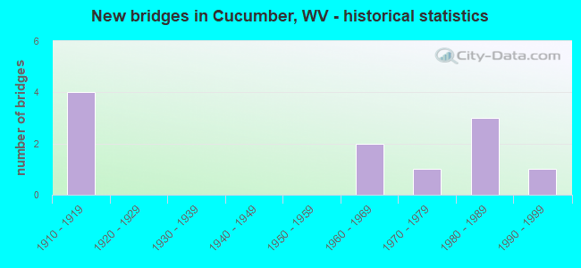
- New bridges - historical statistics
- 41910-1919
- 21960-1969
- 11970-1979
- 31980-1989
- 11990-1999

- Reconstructed bridges - Historical Statistics
- 11980-1989
- 01990-1999
- 02000-2009
- 02010-2019
- 12020-2022

- Bridge Condition - Deck
- 25.0%Satisfactory
- 50.0%Fair
- 12.5%Poor
- 12.5%Serious

- Bridge Condition - Superstructure
- 10.0%Very good
- 60.0%Fair
- 10.0%Poor
- 20.0%Serious

- Bridge Condition - Substructure
- 10.0%Good
- 10.0%Satisfactory
- 50.0%Fair
- 30.0%Poor

- Bridge Condition - Channel
- 10.0%Very good
- 50.0%Good
- 20.0%Satisfactory
- 10.0%Fair
- 10.0%Poor
Find on map >> Show street view
Structure Number: 24A078, Location: 0.03 MI. W. OF WV. 16 (Lat: 37.237781, Lng: -81.610469), Route carried "on" structure: County highway 1100, Year Built: 1916, Status: Posted for load, Structure Length: 2.19m (7.19ft), Average Daily Traffic: 500 (year 2018), Truck Traffic: 6%, Average Future Daily Traffic: 500 (year 2038), Features Intersected: JACOBS FORK, Facility Carried by Structure: CR. 11
Minimum Vertical Clearance: 30+ m (98+ ft), Kilometerpoint: 3.187, Lanes on structure: 1, Owner: State Highway Agency, Approaching Roadway Width: 7.3m (24.0ft), Material/Design: Concrete, Design/Construction: Arch - Deck, Number Of Spans In Main Unit: 1, Length of Maximum Span: 15.2m (49.9ft), Curb-To-Curb Width: 4.5m (14.8ft), Out-to-Out Width: 5.5m (18.0ft)
Condition: Superstructure: Fair, Substructure: Fair, Channel: Poor, Operating Rating: 28.1 metric tons, Method Used To Determine Operating Rating: Field evaluation and documented engineering judgment, Inventory Rating: 11.8 metric tons, Method Used To Determine Inventory Rating: Field evaluation and documented engineering judgment, Structural Evaluation: Meets minimum limits, Deck Geometry: High priority of replacement, Waterway Adequacy: Equal to present desirable criteria, Approach Roadway Alignment: Equal to present minimum criteria, Length Of Structure Improvement: 2.19m (7.19ft), Designated Inspection Frequency: Every 24 months, Inspection Date: May 2020, Bridge Improvement Cost: $650,000, Roadway Improvement Cost: $50,000, Total Project Cost: $700,000 ( Estimate for 2014)
Find on map >> Show street view
Structure Number: 24A088, Location: 0.11 MI E OF WV 16 (Lat: 37.265500, Lng: -81.617181), Route carried "on" structure: County highway 1206, Year Built: 1915, Year Reconstructed: 1985, Status: Open, Structure Length: 1.93m (6.33ft), Average Daily Traffic: 250 (year 2019), Truck Traffic: 6%, Average Future Daily Traffic: 250 (year 2039), Design Load: HS 20, Features Intersected: CUCUMBER CREEK, Facility Carried by Structure: CR 12/6
Minimum Vertical Clearance: 30+ m (98+ ft), Kilometerpoint: 0.177, Lanes on structure: 1, Owner: State Highway Agency, Approaching Roadway Width: 4.9m (16.1ft), Skew: 4 degrees, Material/Design: Steel, Design/Construction: Stringer/Multi-beam, Number Of Spans In Main Unit: 2, Length of Maximum Span: 8.5m (27.9ft), Curb-To-Curb Width: 4.5m (14.8ft), Out-to-Out Width: 5.0m (16.4ft)
Condition: Deck: Fair, Superstructure: Fair, Substructure: Fair, Channel: Satisfactory, Operating Rating: 78.0 metric tons, Method Used To Determine Operating Rating: Load Factor (LF), Inventory Rating: 46.3 metric tons, Method Used To Determine Inventory Rating: Load Factor (LF), Structural Evaluation: Somewhat better than minimum adequacy, Deck Geometry: High priority of replacement, Waterway Adequacy: Superior to present desirable criteria, Approach Roadway Alignment: Meets minimum limits, Length Of Structure Improvement: 1.92m (6.30ft), Designated Inspection Frequency: Every 24 months, Other Special Inspection Frequency: Every 12 months, Inspection Date: May 2021, Other Special Inspection Date: May 2021, Bridge Improvement Cost: $500,000, Roadway Improvement Cost: $50,000, Total Project Cost: $550,000 ( Estimate for 2019), Deck Structure Type: Wood or Timber, Wearing Surface/Protective System: Wearing Surface: Bituminous
Find on map >> Show street view
Structure Number: 24A1, Location: 0.14 MI N OF CR 12/6 (Lat: 37.266119, Lng: -81.620669), Route carried "on" structure: State highway 1600, Year Built: 1979, Year Reconstructed: 2020, Status: Open, Structure Length: 2.46m (8.07ft), Average Daily Traffic: 950 (year 2018), Truck Traffic: 17%, Average Future Daily Traffic: 950 (year 2038), Design Load: HL 93, Features Intersected: JACOBS FORK, Facility Carried by Structure: WV 16
Minimum Vertical Clearance: 30+ m (98+ ft), Kilometerpoint: 10.139, Lanes on structure: 2, Owner: State Highway Agency, Approaching Roadway Width: 6.7m (22.0ft), Skew: 4 degrees, Material/Design: Prestressed concrete, Design/Construction: Box Beam or Girders - Multiple, Number Of Spans In Main Unit: 1, Length of Maximum Span: 22.8m (74.8ft), Curb-To-Curb Width: 8.3m (27.2ft), Out-to-Out Width: 8.4m (27.6ft)
Condition: Deck: Satisfactory, Superstructure: Very good, Substructure: Good, Channel: Very good, Operating Rating: 67.1 metric tons, Method Used To Determine Operating Rating: Load and Resistance Factor (LRFR), Inventory Rating: 51.7 metric tons, Method Used To Determine Inventory Rating: Load and Resistance Factor (LRFR), Structural Evaluation: Better than present minimum criteria, Deck Geometry: Somewhat better than minimum adequacy, Waterway Adequacy: Equal to present desirable criteria, Approach Roadway Alignment: Meets minimum limits, Designated Inspection Frequency: Every 24 months, Inspection Date: Febuary 2021, Deck Structure Type: Other, Wearing Surface/Protective System: Wearing Surface: Integral Concrete, Deck Protection: Epoxy Coated Reinforcing
Find on map >> Show street view
Structure Number: 24A101, Location: 0.15 MI S OF CR 16/2 (Lat: 37.266039, Lng: -81.623450), Route carried "on" structure: State highway 1600, Year Built: 1916, Status: Posted for load, Structure Length: 2.16m (7.09ft), Average Daily Traffic: 950 (year 2018), Truck Traffic: 17%, Average Future Daily Traffic: 950 (year 2038), Features Intersected: JACOBS FORK, Facility Carried by Structure: WV 16
Minimum Vertical Clearance: 30+ m (98+ ft), Kilometerpoint: 10.380, Lanes on structure: 2, Base Highway Network: Yes, Owner: State Highway Agency, Approaching Roadway Width: 6.7m (22.0ft), Skew: 4 degrees, Material/Design: Concrete, Design/Construction: Arch - Deck, Number Of Spans In Main Unit: 1, Length of Maximum Span: 15.4m (50.5ft), Curb-To-Curb Width: 8.3m (27.2ft), Out-to-Out Width: 9.2m (30.2ft)
Condition: Superstructure: Serious, Substructure: Poor, Channel: Good, Operating Rating: 23.6 metric tons, Method Used To Determine Operating Rating: Field evaluation and documented engineering judgment, Inventory Rating: 10.0 metric tons, Method Used To Determine Inventory Rating: Field evaluation and documented engineering judgment, Structural Evaluation: High priority of replacement, Deck Geometry: Somewhat better than minimum adequacy, Waterway Adequacy: Equal to present desirable criteria, Approach Roadway Alignment: Meets minimum limits, Bridge Posting: Required (Relationship of Operating Rating to Maximum Legal Load: 30.0 - 39.9% below), Length Of Structure Improvement: 2.16m (7.09ft), Designated Inspection Frequency: Every 24 months, Other Special Inspection Frequency: Every 12 months, Inspection Date: January 2021, Other Special Inspection Date: January 2021, Bridge Improvement Cost: $800,000, Roadway Improvement Cost: $100,000, Total Project Cost: $900,000 ( Estimate for 2021)
Find on map >> Show street view
Structure Number: 24A102, Location: 0.39 MI N OF CR 12/6 (Lat: 37.267119, Lng: -81.623750), Route carried "on" structure: State highway 1600, Year Built: 1916, Status: Posted for load, Structure Length: 2.01m (6.59ft), Average Daily Traffic: 950 (year 2018), Truck Traffic: 17%, Average Future Daily Traffic: 950 (year 2038), Features Intersected: JACOBS FORK, Facility Carried by Structure: WV 16
Minimum Vertical Clearance: 30+ m (98+ ft), Kilometerpoint: 10.541, Lanes on structure: 2, Base Highway Network: Yes, Owner: State Highway Agency, Approaching Roadway Width: 6.1m (20.0ft), Skew: 4 degrees, Material/Design: Concrete, Design/Construction: Arch - Deck, Number Of Spans In Main Unit: 1, Length of Maximum Span: 13.7m (44.9ft), Curb-To-Curb Width: 8.4m (27.6ft), Out-to-Out Width: 9.1m (29.9ft)
Condition: Deck: Serious, Superstructure: Serious, Substructure: Fair, Channel: Good, Operating Rating: 28.1 metric tons, Method Used To Determine Operating Rating: Field evaluation and documented engineering judgment, Inventory Rating: 11.8 metric tons, Method Used To Determine Inventory Rating: Field evaluation and documented engineering judgment, Structural Evaluation: High priority of replacement, Deck Geometry: Somewhat better than minimum adequacy, Waterway Adequacy: Equal to present minimum criteria, Approach Roadway Alignment: High priority of corrective action, Bridge Posting: Required (Relationship of Operating Rating to Maximum Legal Load: 10.0 - 19.9% below), Length Of Structure Improvement: 2.01m (6.59ft), Designated Inspection Frequency: Every 24 months, Inspection Date: March 2021, Bridge Improvement Cost: $1,250,000, Roadway Improvement Cost: $250,000, Total Project Cost: $1,500,000 ( Estimate for 2021)
Find on map >> Show street view
Structure Number: 24A103, Location: 0.04 MI.N.OFCR.16/2 (Lat: 37.278950, Lng: -81.628150), Route carried "on" structure: State highway 1600, Year Built: 1968, Status: Open, Structure Length: 2.37m (7.78ft), Average Daily Traffic: 950 (year 2019), Truck Traffic: 17%, Average Future Daily Traffic: 950 (year 2039), Features Intersected: JACOBS FORK, Facility Carried by Structure: WV 16
Minimum Vertical Clearance: 30+ m (98+ ft), Kilometerpoint: 12.295, Lanes on structure: 2, Base Highway Network: Yes, Owner: State Highway Agency, Approaching Roadway Width: 6.7m (22.0ft), Skew: 9 degrees, Material/Design: Concrete continuous, Design/Construction: Frame, Number Of Spans In Main Unit: 1, Number Of Approach Spans: 2, Length of Maximum Span: 8.2m (26.9ft), Curb-To-Curb Width: 12.2m (40.0ft), Out-to-Out Width: 12.9m (42.3ft)
Condition: Deck: Fair, Superstructure: Fair, Substructure: Fair, Channel: Satisfactory, Operating Rating: 53.5 metric tons, Method Used To Determine Operating Rating: Field evaluation and documented engineering judgment, Inventory Rating: 24.5 metric tons, Method Used To Determine Inventory Rating: Field evaluation and documented engineering judgment, Structural Evaluation: Somewhat better than minimum adequacy, Deck Geometry: Equal to present desirable criteria, Waterway Adequacy: Equal to present minimum criteria, Approach Roadway Alignment: Better than present minimum criteria, Designated Inspection Frequency: Every 24 months, Other Special Inspection Frequency: Every 12 months, Inspection Date: April 2020, Other Special Inspection Date: April 2021, Deck Structure Type: Concrete Cast-file-Place, Wearing Surface/Protective System: Wearing Surface: Bituminous
Find on map >> Show street view
Structure Number: 24A222, Location: 0.06 MI NORTH OF WV 16 (Lat: 37.271081, Lng: -81.620750), Route carried "on" structure: County highway 1617, Year Built: 1988, Status: Open, Structure Length: 1.67m (5.48ft), Average Daily Traffic: 70 (year 2018), Truck Traffic: 6%, Average Future Daily Traffic: 70 (year 2038), Design Load: HS 20, Features Intersected: JACOBS FORK, Facility Carried by Structure: COUNTY ROUTE 16/17
Minimum Vertical Clearance: 30+ m (98+ ft), Kilometerpoint: 0.097, Lanes on structure: 1, Owner: State Highway Agency, Approaching Roadway Width: 6.1m (20.0ft), Skew: 3 degrees, Material/Design: Steel, Design/Construction: Stringer/Multi-beam, Number Of Spans In Main Unit: 1, Length of Maximum Span: 15.1m (49.5ft), Curb-To-Curb Width: 4.8m (15.7ft), Out-to-Out Width: 5.0m (16.4ft)
Condition: Deck: Satisfactory, Superstructure: Fair, Substructure: Poor, Channel: Fair, Operating Rating: 88.9 metric tons, Method Used To Determine Operating Rating: Load Factor (LF), Inventory Rating: 82.5 metric tons, Method Used To Determine Inventory Rating: Load Factor (LF), Structural Evaluation: Meets minimum limits, Deck Geometry: Equal to present desirable criteria, Waterway Adequacy: Equal to present minimum criteria, Approach Roadway Alignment: Equal to present minimum criteria, Length Of Structure Improvement: 1.51m (4.95ft), Designated Inspection Frequency: Every 24 months, Inspection Date: August 2020, Bridge Improvement Cost: $550,000, Roadway Improvement Cost: $100,000, Total Project Cost: $650,000 ( Estimate for 2018), Deck Structure Type: Wood or Timber, Wearing Surface/Protective System: Wearing Surface: Bituminous
Find on map >> Show street view
Structure Number: 24A228, Location: 0.03 MI. S. OF CR.16/11 (Lat: 37.261861, Lng: -81.621081), Route carried "on" structure: County highway 1612, Year Built: 1980, Status: Open, Structure Length: 1.59m (5.22ft), Average Daily Traffic: 20 (year 2018), Truck Traffic: 6%, Average Future Daily Traffic: 20 (year 2038), Features Intersected: JACOBS FORK, Facility Carried by Structure: CR. 16/12
Minimum Vertical Clearance: 30+ m (98+ ft), Kilometerpoint: 0.048, Lanes on structure: 1, Owner: State Highway Agency, Approaching Roadway Width: 5.5m (18.0ft), Material/Design: Steel, Design/Construction: Stringer/Multi-beam, Number Of Spans In Main Unit: 1, Length of Maximum Span: 13.6m (44.6ft), Curb or Sidewalk Widths: Left: 0.2m (0.7ft), Right: 0.2m (0.7ft), Curb-To-Curb Width: 3.3m (10.8ft), Out-to-Out Width: 3.7m (12.1ft)
Condition: Deck: Fair, Superstructure: Fair, Substructure: Poor, Channel: Good, Operating Rating: 66.2 metric tons, Method Used To Determine Operating Rating: Load Factor (LF), Inventory Rating: 39.0 metric tons, Method Used To Determine Inventory Rating: Load Factor (LF), Structural Evaluation: Meets minimum limits, Deck Geometry: High priority of replacement, Waterway Adequacy: Better than present minimum criteria, Approach Roadway Alignment: Meets minimum limits, Length Of Structure Improvement: 1.59m (5.22ft), Designated Inspection Frequency: Every 24 months, Critical Feature Inspection Frequency: Every 24 months, Inspection Date: June 2020, Critical Feature Inspection Date: June 2020, Bridge Improvement Cost: $400,000, Roadway Improvement Cost: $25,000, Total Project Cost: $425,000 ( Estimate for 2020), Deck Structure Type: Wood or Timber
Find on map >> Show street view
Structure Number: 24A231, Location: 0.01 MI. S. OF WV. 16 (Lat: 37.265089, Lng: -81.619169), Route carried "on" structure: County highway 1613, Year Built: 1989, Status: Open, Structure Length: 1.64m (5.38ft), Average Daily Traffic: 20 (year 2018), Truck Traffic: 6%, Average Future Daily Traffic: 20 (year 2038), Design Load: HS 25 or greater, Features Intersected: JACOBS FORK, Facility Carried by Structure: CR. 16/13
Minimum Vertical Clearance: 30+ m (98+ ft), Kilometerpoint: 0.016, Lanes on structure: 2, Owner: State Highway Agency, Approaching Roadway Width: 4.3m (14.1ft), Material/Design: Prestressed concrete, Design/Construction: Box Beam or Girders - Multiple, Number Of Spans In Main Unit: 1, Length of Maximum Span: 15.2m (49.9ft), Curb-To-Curb Width: 6.4m (21.0ft), Out-to-Out Width: 6.5m (21.3ft)
Condition: Deck: Poor, Superstructure: Poor, Substructure: Fair, Channel: Good, Operating Rating: 88.9 metric tons, Method Used To Determine Operating Rating: Load Factor (LF), Inventory Rating: 68.9 metric tons, Method Used To Determine Inventory Rating: Load Factor (LF), Structural Evaluation: Meets minimum limits, Deck Geometry: Somewhat better than minimum adequacy, Waterway Adequacy: Better than present minimum criteria, Approach Roadway Alignment: Meets minimum limits, Length Of Structure Improvement: 1.64m (5.38ft), Designated Inspection Frequency: Every 24 months, Inspection Date: March 2020, Bridge Improvement Cost: $600,000, Roadway Improvement Cost: $50,000, Total Project Cost: $650,000 ( Estimate for 2020), Deck Structure Type: Other, Wearing Surface/Protective System: Deck Protection: Epoxy Coated Reinforcing
Find on map >> Show street view
Structure Number: 24A239, Location: 0.01 MI. S. OF WV. 16 (Lat: 37.286650, Lng: -81.639050), Route carried "on" structure: County highway 1609, Year Built: 1995, Status: Open, Structure Length: 1.27m (4.17ft), Average Daily Traffic: 20 (year 2018), Truck Traffic: 6%, Average Future Daily Traffic: 20 (year 2038), Design Load: HS 25 or greater, Features Intersected: JACOBS FORK, Facility Carried by Structure: CR. 16/9
Minimum Vertical Clearance: 30+ m (98+ ft), Kilometerpoint: 0.016, Lanes on structure: 2, Owner: State Highway Agency, Approaching Roadway Width: 4.9m (16.1ft), Material/Design: Prestressed concrete, Design/Construction: Box Beam or Girders - Multiple, Number Of Spans In Main Unit: 1, Length of Maximum Span: 11.6m (38.1ft), Curb-To-Curb Width: 6.5m (21.3ft), Out-to-Out Width: 6.6m (21.7ft)
Condition: Deck: Fair, Superstructure: Fair, Substructure: Satisfactory, Channel: Good, Operating Rating: 88.9 metric tons, Method Used To Determine Operating Rating: Load Factor (LF), Inventory Rating: 60.8 metric tons, Method Used To Determine Inventory Rating: Load Factor (LF), Structural Evaluation: Somewhat better than minimum adequacy, Deck Geometry: Somewhat better than minimum adequacy, Waterway Adequacy: Better than present minimum criteria, Approach Roadway Alignment: Meets minimum limits, Designated Inspection Frequency: Every 24 months, Inspection Date: January 2020, Deck Structure Type: Other, Wearing Surface/Protective System: Deck Protection: Epoxy Coated Reinforcing
Find on map >> Show street view
Structure Number: 24A104, Location: 0.08 MI NORTH OF CR 16/2 (Lat: 37.279669, Lng: -81.628239), Route carried "under" structure: State highway 1600, Year Built: 1969, Structure Length: 0. m, Average Daily Traffic: 950 (year 2018), Truck Traffic: 17%, Features Intersected: NORFOLK SOUTHERN RW, Facility Carried by Structure: NS RAILWAY
Minimum Vertical Clearance: 4.42m (14.50ft), Kilometerpoint: 12.360, Lanes under structure: 2, Material/Design: Steel, Design/Construction: Stringer/Multi-beam, Length of Maximum Span: 17.1m (56.1ft)