Bridge Statistics for Cumberland, Virginia (VA)
Condition, Traffic, Stress, Structural Evaluation, Project Costs
- National Bridge Inventory (NBI) Statistics
- 13Number of bridges
- 72ft / 21.7mTotal length
- $2,065,000Total costs
- 4,652Total average daily traffic
- 222Total average daily truck traffic
- 5,534Total future (year 2040) average daily traffic
- National Bridge Inventory (NBI) Registered Bridges for Cumberland
- No street view available for this location
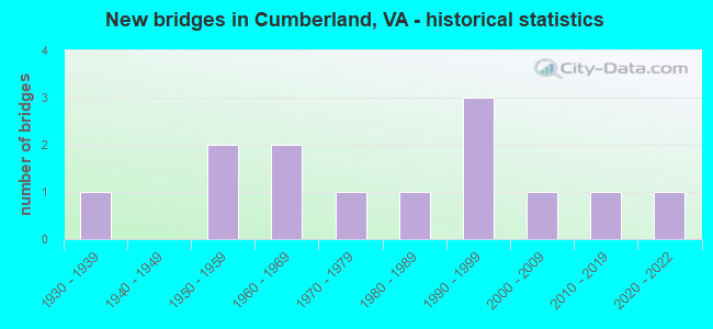
- New bridges - historical statistics
- 11930-1939
- 21950-1959
- 21960-1969
- 11970-1979
- 11980-1989
- 31990-1999
- 12000-2009
- 12010-2019
- 12020-2022

- Bridge Condition - Deck
- 30.0%Very good
- 50.0%Good
- 20.0%Satisfactory

- Bridge Condition - Superstructure
- 40.0%Very good
- 40.0%Good
- 20.0%Satisfactory

- Bridge Condition - Substructure
- 20.0%Very good
- 70.0%Good
- 10.0%Satisfactory

- Bridge Condition - Channel
- 69.2%Good
- 23.1%Satisfactory
- 7.7%Fair

- Bridge Condition - Culverts
- 33.3%Excellent
- 33.3%Good
- 33.3%Satisfactory
Find on map >> Show street view
Structure Number: 5711, Location: 0.02 Rt 633/0.79 Buck CL (Lat: 37.484192, Lng: -78.320803), Route carried "on" structure: US 60, Year Built: 1988, Status: Open, Structure Length: 4.33m (14.21ft), Average Daily Traffic: 2,405 (year 2020), Truck Traffic: 9%, Average Future Daily Traffic: 2,646 (year 2040), Design Load: HS 20+Mod, Features Intersected: Willis River, Facility Carried by Structure: Anderson Highway
Minimum Vertical Clearance: 30+ m (98+ ft), Kilometerpoint: 221.286, Lanes on structure: 2, Base Highway Network: Yes, Owner: State Highway Agency, Approaching Roadway Width: 8.5m (27.9ft), Material/Design: Steel, Design/Construction: Stringer/Multi-beam, Number Of Spans In Main Unit: 2, Length of Maximum Span: 20.8m (68.2ft), Curb-To-Curb Width: 12.8m (42.0ft), Out-to-Out Width: 14.0m (45.9ft)
Condition: Deck: Good, Superstructure: Good, Substructure: Good, Channel: Good, Operating Rating: 89.8 metric tons, Method Used To Determine Operating Rating: Load and Resistance Factor (LRFR), Inventory Rating: 83.5 metric tons, Method Used To Determine Inventory Rating: Load and Resistance Factor (LRFR), Structural Evaluation: Better than present minimum criteria, Deck Geometry: Equal to present minimum criteria, Waterway Adequacy: Equal to present desirable criteria, Approach Roadway Alignment: Equal to present desirable criteria, Designated Inspection Frequency: Every 24 months, Inspection Date: April 2020, Deck Structure Type: Concrete Cast-file-Place, Wearing Surface/Protective System: Deck Protection: Epoxy Coated Reinforcing
Find on map >> Show street view
Structure Number: 572, Location: 0.58-Rt.620 / 0.30-Rt.631 (Lat: 37.442392, Lng: -78.206669), Route carried "on" structure: County highway 600, Year Built: 1952, Status: Posted for load, Structure Length: 2.99m (9.81ft), Average Daily Traffic: 502 (year 2017), Average Future Daily Traffic: 733 (year 2040), Features Intersected: Big Guinea Creek, Facility Carried by Structure: Stoney Point Road
Minimum Vertical Clearance: 30+ m (98+ ft), Kilometerpoint: 8.467, Lanes on structure: 2, Owner: State Highway Agency, Approaching Roadway Width: 5.2m (17.1ft), Material/Design: Steel, Design/Construction: Stringer/Multi-beam, Number Of Spans In Main Unit: 3, Length of Maximum Span: 10.0m (32.8ft), Curb or Sidewalk Widths: Left: 0.3m (1.0ft), Right: 0.3m (1.0ft), Curb-To-Curb Width: 6.1m (20.0ft), Out-to-Out Width: 6.7m (22.0ft)
Condition: Deck: Satisfactory, Superstructure: Satisfactory, Substructure: Good, Channel: Satisfactory, Operating Rating: 35.4 metric tons, Method Used To Determine Operating Rating: Load Factor (LF), Inventory Rating: 20.9 metric tons, Method Used To Determine Inventory Rating: Load Factor (LF), Structural Evaluation: Somewhat better than minimum adequacy, Deck Geometry: High priority of corrective action, Waterway Adequacy: Somewhat better than minimum adequacy, Approach Roadway Alignment: Equal to present minimum criteria, Length Of Structure Improvement: 3.87m (12.70ft), Designated Inspection Frequency: Every 12 months, Inspection Date: July 2021, Bridge Improvement Cost: $391,000, Roadway Improvement Cost: $39,000, Total Project Cost: $587,000 ( Estimate for 2015), Deck Structure Type: Concrete Cast-file-Place, Wearing Surface/Protective System: Wearing Surface: Latex Concrete, Membrane: Other
Find on map >> Show street view
Structure Number: 575, Location: 2.27 to 633 / 1.98 to 628 (Lat: 37.506764, Lng: -78.308572), Route carried "on" structure: County highway 629, Year Built: 1932, Status: Open, Structure Length: 0.79m (2.59ft), Average Daily Traffic: 56 (year 2017), Average Future Daily Traffic: 62 (year 2040), Features Intersected: Rock Point Creek, Facility Carried by Structure: Oak Hill Road
Minimum Vertical Clearance: 30+ m (98+ ft), Kilometerpoint: 3.887, Lanes on structure: 2, Owner: State Highway Agency, Approaching Roadway Width: 5.2m (17.1ft), Material/Design: Concrete, Design/Construction: Slab, Number Of Spans In Main Unit: 1, Length of Maximum Span: 7.3m (24.0ft), Curb or Sidewalk Widths: Left: 0.5m (1.6ft), Right: 0.5m (1.6ft), Curb-To-Curb Width: 5.8m (19.0ft), Out-to-Out Width: 6.6m (21.7ft)
Condition: Deck: Satisfactory, Superstructure: Satisfactory, Substructure: Satisfactory, Channel: Satisfactory, Operating Rating: 49.9 metric tons, Method Used To Determine Operating Rating: Field evaluation and documented engineering judgment, Inventory Rating: 29.9 metric tons, Method Used To Determine Inventory Rating: Field evaluation and documented engineering judgment, Structural Evaluation: Equal to present minimum criteria, Deck Geometry: Meets minimum limits, Waterway Adequacy: Equal to present minimum criteria, Approach Roadway Alignment: Equal to present desirable criteria, Length Of Structure Improvement: 1.43m (4.69ft), Designated Inspection Frequency: Every 12 months, Inspection Date: April 2021, Bridge Improvement Cost: $280,000, Roadway Improvement Cost: $25,000, Total Project Cost: $375,000, Deck Structure Type: Concrete Cast-file-Place
Find on map >> Show street view
Structure Number: 5752, Location: 0.43 to 600 - 0.37 to 644 (Lat: 37.446356, Lng: -78.214136), Route carried "on" structure: County highway 631, Year Built: 1954, Year Reconstructed: 2000, Status: Open, Structure Length: 0.79m (2.59ft), Average Daily Traffic: 54 (year 2020), Average Future Daily Traffic: 59 (year 2040), Design Load: HS 20, Features Intersected: Tearwallet Creek, Facility Carried by Structure: Davenport Road
Minimum Vertical Clearance: 30+ m (98+ ft), Kilometerpoint: 7.192, Lanes on structure: 2, Owner: State Highway Agency, Approaching Roadway Width: 5.5m (18.0ft), Material/Design: Steel, Design/Construction: Stringer/Multi-beam, Number Of Spans In Main Unit: 1, Length of Maximum Span: 6.8m (22.3ft), Curb-To-Curb Width: 6.7m (22.0ft), Out-to-Out Width: 6.9m (22.6ft)
Condition: Deck: Very good, Superstructure: Very good, Substructure: Good, Channel: Good, Operating Rating: 60.8 metric tons, Method Used To Determine Operating Rating: Load and Resistance Factor (LRFR), Inventory Rating: 47.2 metric tons, Method Used To Determine Inventory Rating: Load and Resistance Factor (LRFR), Structural Evaluation: Better than present minimum criteria, Deck Geometry: Somewhat better than minimum adequacy, Waterway Adequacy: Somewhat better than minimum adequacy, Approach Roadway Alignment: Equal to present desirable criteria, Designated Inspection Frequency: Every 24 months, Inspection Date: June 2020, Deck Structure Type: Wood or Timber, Wearing Surface/Protective System: Wearing Surface: Bituminous
Find on map >> Show street view
Structure Number: 5753, Location: 0.10 to 60 / 0.94 to 629 (Lat: 37.484547, Lng: -78.318494), Route carried "on" structure: County highway 633, Year Built: 1961, Year Reconstructed: 2011, Status: Open, Structure Length: 1.09m (3.58ft), Average Daily Traffic: 21 (year 2020), Average Future Daily Traffic: 23 (year 2040), Design Load: HS 20+Mod, Features Intersected: Rock Creek, Facility Carried by Structure: Rock Creek Road
Minimum Vertical Clearance: 30+ m (98+ ft), Kilometerpoint: 7.038, Lanes on structure: 2, Owner: State Highway Agency, Approaching Roadway Width: 4.6m (15.1ft), Material/Design: Steel, Design/Construction: Stringer/Multi-beam, Number Of Spans In Main Unit: 1, Length of Maximum Span: 9.8m (32.2ft), Curb-To-Curb Width: 6.2m (20.3ft), Out-to-Out Width: 6.9m (22.6ft)
Condition: Deck: Very good, Superstructure: Very good, Substructure: Very good, Channel: Good, Operating Rating: 86.2 metric tons, Method Used To Determine Operating Rating: Load Factor (LF), Inventory Rating: 51.7 metric tons, Method Used To Determine Inventory Rating: Load Factor (LF), Structural Evaluation: Equal to present desirable criteria, Deck Geometry: Somewhat better than minimum adequacy, Waterway Adequacy: Somewhat better than minimum adequacy, Approach Roadway Alignment: Equal to present minimum criteria, Length Of Structure Improvement: 1.65m (5.41ft), Designated Inspection Frequency: Every 24 months, Inspection Date: April 2021, Bridge Improvement Cost: $166,000, Roadway Improvement Cost: $17,000, Total Project Cost: $249,000, Deck Structure Type: Wood or Timber, Wearing Surface/Protective System: Wearing Surface: Bituminous, Membrane: Other
Find on map >> Show street view
Structure Number: 5759, Location: 1.30 to 45 - 0.70 to 660 (Lat: 37.427219, Lng: -78.318056), Route carried "on" structure: County highway 640, Year Built: 1968, Year Reconstructed: 2008, Status: Open, Structure Length: 1.26m (4.13ft), Average Daily Traffic: 364 (year 2017), Average Future Daily Traffic: 414 (year 2040), Features Intersected: Little Guinea Creek, Facility Carried by Structure: Holman Mill Road
Minimum Vertical Clearance: 30+ m (98+ ft), Kilometerpoint: 4.666, Lanes on structure: 2, Owner: State Highway Agency, Approaching Roadway Width: 5.2m (17.1ft), Material/Design: Steel, Design/Construction: Stringer/Multi-beam, Number Of Spans In Main Unit: 1, Length of Maximum Span: 11.5m (37.7ft), Curb-To-Curb Width: 6.7m (22.0ft), Out-to-Out Width: 7.3m (24.0ft)
Condition: Deck: Very good, Superstructure: Very good, Substructure: Good, Channel: Good, Operating Rating: 51.7 metric tons, Method Used To Determine Operating Rating: Load Factor (LF), Inventory Rating: 30.8 metric tons, Method Used To Determine Inventory Rating: Load Factor (LF), Structural Evaluation: Better than present minimum criteria, Deck Geometry: Meets minimum limits, Waterway Adequacy: Somewhat better than minimum adequacy, Approach Roadway Alignment: Meets minimum limits, Length Of Structure Improvement: 1.92m (6.30ft), Designated Inspection Frequency: Every 24 months, Inspection Date: April 2020, Bridge Improvement Cost: $335,000, Roadway Improvement Cost: $33,000, Total Project Cost: $503,000 ( Estimate for 2014), Deck Structure Type: Wood or Timber, Wearing Surface/Protective System: Wearing Surface: Bituminous, Membrane: Preformed Fabric
Find on map >> Show street view
Structure Number: 5761, Location: 2.00 to 13 - 0.50 to 600 (Lat: 37.481781, Lng: -78.220111), Route carried "on" structure: County highway 643, Year Built: 1974, Status: Open, Structure Length: 0.63m (2.07ft), Average Daily Traffic: 181 (year 2020), Average Future Daily Traffic: 253 (year 2040), Design Load: HS 20, Features Intersected: Trib.Little Guinea Creek, Facility Carried by Structure: Mottley Mill Road
Minimum Vertical Clearance: 30+ m (98+ ft), Kilometerpoint: 0.805, Lanes on structure: 2, Owner: State Highway Agency, Approaching Roadway Width: 5.2m (17.1ft), Material/Design: Concrete, Design/Construction: Culvert, Number Of Spans In Main Unit: 2, Length of Maximum Span: 3.1m (10.2ft)
Condition: Channel: Good, Culverts: Satisfactory, Operating Rating: 84.4 metric tons, Method Used To Determine Operating Rating: Load Factor (LF), Inventory Rating: 49.9 metric tons, Method Used To Determine Inventory Rating: Load Factor (LF), Structural Evaluation: Equal to present minimum criteria, Waterway Adequacy: Better than present minimum criteria, Approach Roadway Alignment: Equal to present minimum criteria, Designated Inspection Frequency: Every 24 months, Inspection Date: March 2021
Find on map >> Show street view
Structure Number: 24708, Location: 0.95 to 642 - 0.85 to 631 (Lat: 37.468114, Lng: -78.242781), Route carried "on" structure: County highway 641, Year Built: 1996, Status: Open, Structure Length: 0.78m (2.56ft), Average Daily Traffic: 344 (year 2020), Average Future Daily Traffic: 482 (year 2040), Design Load: HS 20, Features Intersected: Tear Wallet Creek, Facility Carried by Structure: Simms Road
Minimum Vertical Clearance: 30+ m (98+ ft), Kilometerpoint: 1.368, Lanes on structure: 2, Owner: State Highway Agency, Approaching Roadway Width: 5.5m (18.0ft), Material/Design: Concrete, Design/Construction: Culvert, Number Of Spans In Main Unit: 3, Length of Maximum Span: 2.4m (7.9ft)
Condition: Channel: Fair, Culverts: Good, Operating Rating: 64.4 metric tons, Method Used To Determine Operating Rating: Load Factor (LF), Inventory Rating: 38.1 metric tons, Method Used To Determine Inventory Rating: Load Factor (LF), Structural Evaluation: Better than present minimum criteria, Waterway Adequacy: Better than present minimum criteria, Approach Roadway Alignment: Equal to present desirable criteria, Length Of Structure Improvement: 0.76m (2.49ft), Designated Inspection Frequency: Every 24 months, Inspection Date: November 2021, Bridge Improvement Cost: $234,000, Roadway Improvement Cost: $23,000, Total Project Cost: $351,000
Find on map >> Show street view
Structure Number: 24989, Location: 1.56 to 600 / 1.51 to 13 (Lat: 37.469956, Lng: -78.188933), Route carried "on" structure: County highway 654, Year Built: 1997, Status: Open, Structure Length: 1.25m (4.10ft), Average Daily Traffic: 258 (year 2017), Average Future Daily Traffic: 301 (year 2040), Design Load: HS 20+Mod, Features Intersected: Little Guinea Creek, Facility Carried by Structure: Sunnyside Road
Minimum Vertical Clearance: 30+ m (98+ ft), Kilometerpoint: 2.414, Lanes on structure: 2, Owner: State Highway Agency, Approaching Roadway Width: 5.5m (18.0ft), Material/Design: Prestressed concrete, Design/Construction: Slab, Number Of Spans In Main Unit: 1, Length of Maximum Span: 11.7m (38.4ft), Curb-To-Curb Width: 7.2m (23.6ft), Out-to-Out Width: 8.5m (27.9ft)
Condition: Deck: Good, Superstructure: Very good, Substructure: Good, Channel: Good, Operating Rating: 61.7 metric tons, Method Used To Determine Operating Rating: Load and Resistance Factor (LRFR), Inventory Rating: 47.2 metric tons, Method Used To Determine Inventory Rating: Load and Resistance Factor (LRFR), Structural Evaluation: Better than present minimum criteria, Deck Geometry: Meets minimum limits, Waterway Adequacy: Equal to present desirable criteria, Approach Roadway Alignment: Equal to present minimum criteria, Designated Inspection Frequency: Every 24 months, Inspection Date: April 2021, Deck Structure Type: Other, Wearing Surface/Protective System: Wearing Surface: Bituminous, Membrane: Epoxy
Find on map >> Show street view
Structure Number: 26154, Location: 1.68 to 693 - 0.70 to 660 (Lat: 37.421667, Lng: -78.270075), Route carried "on" structure: County highway 639, Year Built: 1999, Status: Open, Structure Length: 3.00m (9.84ft), Average Daily Traffic: 221 (year 2020), Truck Traffic: 3%, Average Future Daily Traffic: 243 (year 2040), Features Intersected: Big Guinea Creek, Facility Carried by Structure: Putney Road
Minimum Vertical Clearance: 30+ m (98+ ft), Kilometerpoint: 2.349, Lanes on structure: 2, Owner: State Highway Agency, Approaching Roadway Width: 6.4m (21.0ft), Skew: 3 degrees, Material/Design: Steel, Design/Construction: Stringer/Multi-beam, Number Of Spans In Main Unit: 1, Length of Maximum Span: 28.1m (92.2ft), Curb-To-Curb Width: 7.2m (23.6ft), Out-to-Out Width: 8.2m (26.9ft)
Condition: Deck: Good, Superstructure: Good, Substructure: Good, Channel: Good, Operating Rating: 55.3 metric tons, Method Used To Determine Operating Rating: Load Factor (LF), Inventory Rating: 32.7 metric tons, Method Used To Determine Inventory Rating: Load Factor (LF), Structural Evaluation: Better than present minimum criteria, Deck Geometry: Meets minimum limits, Waterway Adequacy: Better than present minimum criteria, Approach Roadway Alignment: Equal to present minimum criteria, Designated Inspection Frequency: Every 24 months, Inspection Date: May 2021, Deck Structure Type: Concrete Cast-file-Place, Wearing Surface/Protective System: Deck Protection: Epoxy Coated Reinforcing
Find on map >> Show street view
Structure Number: 28375, Location: 1.00 to 623 - 1.30 to 624 (Lat: 37.544231, Lng: -78.237689), Route carried "on" structure: County highway 626, Year Built: 2006, Status: Open, Structure Length: 0.79m (2.59ft), Average Daily Traffic: 151 (year 2020), Average Future Daily Traffic: 211 (year 2040), Design Load: HS 20+Mod, Features Intersected: Bonbrook Creek, Facility Carried by Structure: Bonbrook Creek Rd
Minimum Vertical Clearance: 30+ m (98+ ft), Kilometerpoint: 1.603, Lanes on structure: 2, Owner: State Highway Agency, Approaching Roadway Width: 4.9m (16.1ft), Material/Design: Concrete, Design/Construction: Frame, Number Of Spans In Main Unit: 1, Length of Maximum Span: 7.3m (24.0ft), Curb-To-Curb Width: 9.5m (31.2ft), Out-to-Out Width: 11.0m (36.1ft)
Condition: Deck: Good, Superstructure: Good, Substructure: Very good, Channel: Good, Operating Rating: 76.2 metric tons, Method Used To Determine Operating Rating: Load and Resistance Factor (LRFR), Inventory Rating: 59.0 metric tons, Method Used To Determine Inventory Rating: Load and Resistance Factor (LRFR), Structural Evaluation: Better than present minimum criteria, Deck Geometry: Equal to present minimum criteria, Waterway Adequacy: Somewhat better than minimum adequacy, Approach Roadway Alignment: Equal to present minimum criteria, Designated Inspection Frequency: Every 24 months, Inspection Date: August 2020
Find on map >> Show street view
Structure Number: 29563, Location: Amelia/Cumberland Co Line (Lat: 37.427706, Lng: -78.230811), Route carried "on" structure: County highway 620, Year Built: 2015, Status: Open, Structure Length: 3.20m (10.50ft), Average Daily Traffic: 66 (year 2020), Average Future Daily Traffic: 75 (year 2040), Design Load: HS 20+Mod, Features Intersected: APPOMATTOX RIVER, Facility Carried by Structure: STONEY POINT ROAD
Minimum Vertical Clearance: 30.18m (99.02ft), Kilometerpoint: 8.914, Lanes on structure: 2, Owner: State Highway Agency, Approaching Roadway Width: 6.7m (22.0ft), Material/Design: Steel, Design/Construction: Truss - Thru, Number Of Spans In Main Unit: 1, Length of Maximum Span: 30.6m (100.4ft), Curb-To-Curb Width: 7.0m (23.0ft), Out-to-Out Width: 7.3m (24.0ft)
Condition: Deck: Good, Superstructure: Good, Substructure: Good, Channel: Satisfactory, Operating Rating: 77.5 metric tons, Method Used To Determine Operating Rating: Load Factor (LF), Inventory Rating: 46.4 metric tons, Method Used To Determine Inventory Rating: Load Factor (LF), Structural Evaluation: Better than present minimum criteria, Deck Geometry: Somewhat better than minimum adequacy, Waterway Adequacy: Equal to present minimum criteria, Approach Roadway Alignment: Meets minimum limits, Designated Inspection Frequency: Every 12 months, Critical Feature Inspection Frequency: Every 12 months, Inspection Date: November 2021, Critical Feature Inspection Date: November 2021, Deck Structure Type: Concrete Cast-file-Place, Wearing Surface/Protective System: Deck Protection: Other
Find on map >> Show street view
Structure Number: 30911, Location: 0.5 Rt 631 / 0.7 Rt 600 (Lat: 37.439886, Lng: -78.219761), Route carried "on" structure: County highway 644, Year Built: 2021, Status: Open, Structure Length: 0.78m (2.56ft), Average Daily Traffic: 29 (year 2020), Average Future Daily Traffic: 32 (year 2040), Design Load: HL 93, Features Intersected: Big Guinea Creek, Facility Carried by Structure: Forest Hill Road
Minimum Vertical Clearance: 30+ m (98+ ft), Kilometerpoint: 0.000, Lanes on structure: 2, Owner: State Highway Agency, Approaching Roadway Width: 5.8m (19.0ft), Skew: 1 degrees, Material/Design: Concrete, Design/Construction: Culvert, Number Of Spans In Main Unit: 2, Length of Maximum Span: 3.7m (12.1ft)
Condition: Channel: Good, Culverts: Excellent, Operating Rating: 61.7 metric tons, Method Used To Determine Operating Rating: Load and Resistance Factor (LRFR), Inventory Rating: 47.2 metric tons, Method Used To Determine Inventory Rating: Load and Resistance Factor (LRFR), Structural Evaluation: Superior to present desirable criteria, Waterway Adequacy: Better than present minimum criteria, Approach Roadway Alignment: Equal to present desirable criteria, Designated Inspection Frequency: Every 24 months, Inspection Date: June 2021