Bridge Statistics for Dakota Ridge, Colorado (CO)
Condition, Traffic, Stress, Structural Evaluation, Project Costs
- National Bridge Inventory (NBI) Statistics
- 18Number of bridges
- 138ft / 42.0mTotal length
- $2,130,000Total costs
- 209,239Total average daily traffic
- 5,622Total average daily truck traffic
- National Bridge Inventory (NBI) Registered Bridges for Dakota Ridge
- No street view available for this location
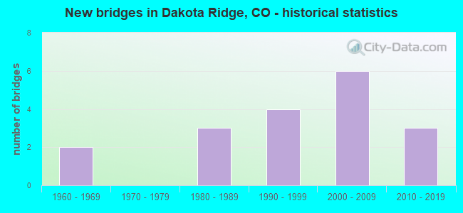
- New bridges - historical statistics
- 21960-1969
- 31980-1989
- 41990-1999
- 62000-2009
- 32010-2019
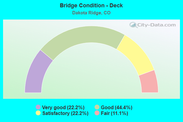
- Bridge Condition - Deck
- 22.2%Very good
- 44.4%Good
- 22.2%Satisfactory
- 11.1%Fair
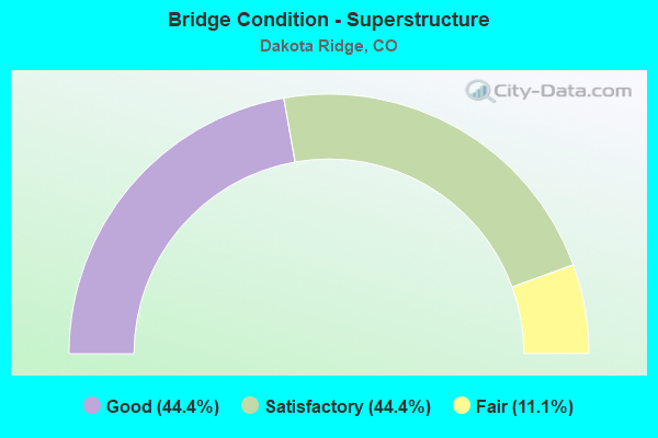
- Bridge Condition - Superstructure
- 44.4%Good
- 44.4%Satisfactory
- 11.1%Fair
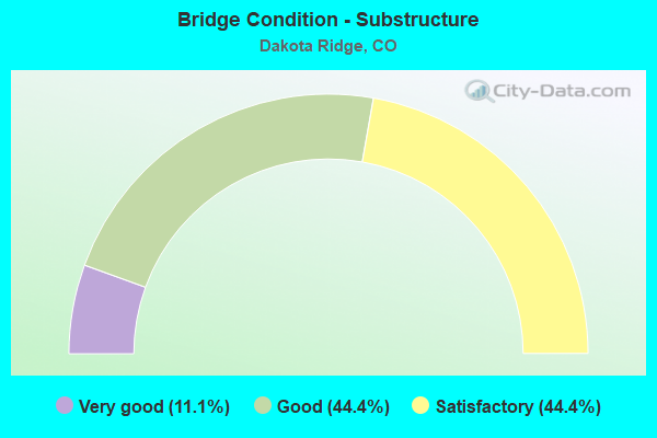
- Bridge Condition - Substructure
- 11.1%Very good
- 44.4%Good
- 44.4%Satisfactory
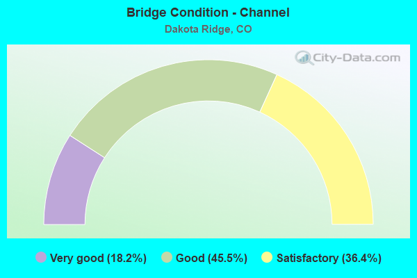
- Bridge Condition - Channel
- 18.2%Very good
- 45.5%Good
- 36.4%Satisfactory
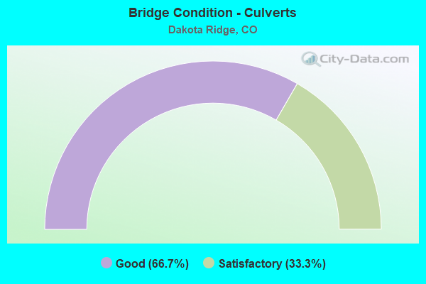
- Bridge Condition - Culverts
- 66.7%Good
- 33.3%Satisfactory
Find on map >> Show street view
Structure Number: F-16-NL, Location: 1.2 MI S OF JCT SH 285 (Lat: 39.624397, Lng: -105.153458), Route carried "on" structure: State highway 470A, Year Built: 1990, Status: Open, Structure Length: 5.88m (19.29ft), Average Daily Traffic: 31,500 (year 2020), Truck Traffic: 2%, Average Future Daily Traffic: 41,580 (year 2040), Design Load: HS 20, Features Intersected: BELLEVIEW AVE, Facility Carried by Structure: SH 470 ML WBND
Minimum Vertical Clearance: 30+ m (98+ ft), Kilometerpoint: 11.103, Lanes on structure: 2, Lanes under structure: 4, Base Highway Network: Yes, Owner: State Highway Agency, Approaching Roadway Width: 11.6m (38.1ft), Skew: 13 degrees, Material/Design: Prestressed concrete continuous, Design/Construction: Stringer/Multi-beam, Number Of Spans In Main Unit: 2, Length of Maximum Span: 29.0m (95.1ft), Curb-To-Curb Width: 11.6m (38.1ft), Out-to-Out Width: 12.6m (41.3ft)
Condition: Deck: Satisfactory, Superstructure: Satisfactory, Substructure: Satisfactory, Operating Rating: 59.2 metric tons, Method Used To Determine Operating Rating: Load Factor (LF), Inventory Rating: 35.5 metric tons, Method Used To Determine Inventory Rating: Load Factor (LF), Structural Evaluation: Equal to present minimum criteria, Deck Geometry: Equal to present minimum criteria, Underclear: Somewhat better than minimum adequacy, Approach Roadway Alignment: Equal to present desirable criteria, Designated Inspection Frequency: Every 24 months, Inspection Date: December 2021, Deck Structure Type: Concrete Cast-file-Place, Wearing Surface/Protective System: Wearing Surface: Bituminous, Membrane: Preformed Fabric, Deck Protection: Epoxy Coated Reinforcing
Find on map >> Show street view
Structure Number: F-16-NM, Location: 1.2 MI S OF JCT SH 285 (Lat: 39.624397, Lng: -105.153769), Route carried "on" structure: State highway 470A, Year Built: 1990, Status: Open, Structure Length: 5.88m (19.29ft), Average Daily Traffic: 31,500 (year 2020), Truck Traffic: 2%, Average Future Daily Traffic: 41,580 (year 2040), Design Load: HS 20+Mod, Features Intersected: BELLEVIEW AVE, Facility Carried by Structure: SH 470 ML EBND
Minimum Vertical Clearance: 30+ m (98+ ft), Kilometerpoint: 11.088, Lanes on structure: 2, Lanes under structure: 4, Base Highway Network: Yes, Owner: State Highway Agency, Approaching Roadway Width: 11.6m (38.1ft), Skew: 13 degrees, Material/Design: Prestressed concrete continuous, Design/Construction: Stringer/Multi-beam, Number Of Spans In Main Unit: 2, Length of Maximum Span: 29.0m (95.1ft), Curb-To-Curb Width: 11.6m (38.1ft), Out-to-Out Width: 12.6m (41.3ft)
Condition: Deck: Satisfactory, Superstructure: Satisfactory, Substructure: Satisfactory, Operating Rating: 50.2 metric tons, Method Used To Determine Operating Rating: Load Factor (LF), Inventory Rating: 30.0 metric tons, Method Used To Determine Inventory Rating: Load Factor (LF), Structural Evaluation: Equal to present minimum criteria, Deck Geometry: Equal to present minimum criteria, Underclear: Meets minimum limits, Approach Roadway Alignment: Equal to present desirable criteria, Designated Inspection Frequency: Every 24 months, Inspection Date: December 2021, Deck Structure Type: Concrete Cast-file-Place, Wearing Surface/Protective System: Wearing Surface: Bituminous, Membrane: Preformed Fabric, Deck Protection: Epoxy Coated Reinforcing
Find on map >> Show street view
Structure Number: F-16-NN, Location: 1.1 MI S OF BELLEVIEW (Lat: 39.609508, Lng: -105.152753), Route carried "on" structure: City street , Year Built: 1990, Status: Open, Structure Length: 6.79m (22.28ft), Average Daily Traffic: 11,524 (year 2021), Truck Traffic: 4%, Average Future Daily Traffic: 13,253 (year 2041), Design Load: HS 20, Features Intersected: SH 470 ML, Facility Carried by Structure: BOWLES AVE
Minimum Vertical Clearance: 30+ m (98+ ft), Kilometerpoint: 0.040, Lanes on structure: 4, Lanes under structure: 4, Owner: State Highway Agency, Approaching Roadway Width: 23.2m (76.1ft), Skew: 2 degrees, Material/Design: Prestressed concrete continuous, Design/Construction: Box Beam or Girders - Multiple, Number Of Spans In Main Unit: 2, Length of Maximum Span: 34.0m (111.5ft), Curb or Sidewalk Widths: Left: 2.9m (9.5ft), Right: 0.0m, Curb-To-Curb Width: 28.7m (94.2ft), Out-to-Out Width: 32.6m (107.0ft)
Condition: Deck: Good, Superstructure: Fair, Substructure: Satisfactory, Operating Rating: 64.9 metric tons, Method Used To Determine Operating Rating: Load Factor (LF), Inventory Rating: 38.8 metric tons, Method Used To Determine Inventory Rating: Load Factor (LF), Structural Evaluation: Somewhat better than minimum adequacy, Deck Geometry: Superior to present desirable criteria, Underclear: Superior to present desirable criteria, Approach Roadway Alignment: Equal to present desirable criteria, Designated Inspection Frequency: Every 24 months, Inspection Date: December 2021, Deck Structure Type: Concrete Cast-file-Place, Wearing Surface/Protective System: Wearing Surface: Bituminous
Find on map >> Show street view
Structure Number: F-16-PI, Location: 0.5 MI S. OF BOWLES (Lat: 39.602008, Lng: -105.153733), Route carried "on" structure: State highway 470A, Year Built: 1988, Status: Open, Structure Length: 8.24m (27.03ft), Average Daily Traffic: 29,000 (year 2020), Truck Traffic: 3%, Average Future Daily Traffic: 39,150 (year 2040), Design Load: HS 20+Mod, Features Intersected: DUTCH CREEK, Facility Carried by Structure: SH 470 ML EBND
Minimum Vertical Clearance: 30+ m (98+ ft), Kilometerpoint: 13.705, Lanes on structure: 2, Base Highway Network: Yes, Owner: State Highway Agency, Approaching Roadway Width: 11.6m (38.1ft), Material/Design: Steel continuous, Design/Construction: Stringer/Multi-beam, Number Of Spans In Main Unit: 2, Length of Maximum Span: 40.8m (133.9ft), Curb-To-Curb Width: 11.6m (38.1ft), Out-to-Out Width: 12.6m (41.3ft)
Condition: Deck: Good, Superstructure: Good, Substructure: Good, Channel: Good, Operating Rating: 70.0 metric tons, Method Used To Determine Operating Rating: Load Factor (LF), Inventory Rating: 42.0 metric tons, Method Used To Determine Inventory Rating: Load Factor (LF), Structural Evaluation: Better than present minimum criteria, Deck Geometry: Equal to present minimum criteria, Waterway Adequacy: Equal to present desirable criteria, Approach Roadway Alignment: Equal to present desirable criteria, Designated Inspection Frequency: Every 24 months, Inspection Date: August 2021, Deck Structure Type: Concrete Cast-file-Place, Wearing Surface/Protective System: Wearing Surface: Bituminous, Membrane: Preformed Fabric, Deck Protection: Epoxy Coated Reinforcing
Find on map >> Show street view
Structure Number: F-16-SG, Location: 0.9 MI E OF JCT SH 8 (Lat: 39.628789, Lng: -105.178700), Route carried "on" structure: US 285D, Year Built: 2008, Status: Open, Structure Length: 2.30m (7.55ft), Average Daily Traffic: 39,000 (year 2020), Truck Traffic: 5%, Average Future Daily Traffic: 50,700 (year 2040), Design Load: HS 25 or greater, Features Intersected: COUNTY ROAD 60, Facility Carried by Structure: US 285 ML
Minimum Vertical Clearance: 30+ m (98+ ft), Kilometerpoint: 140.410, Lanes on structure: 4, Lanes under structure: 2, Base Highway Network: Yes, Owner: State Highway Agency, Approaching Roadway Width: 24.7m (81.0ft), Skew: 32 degrees, Material/Design: Prestressed concrete, Design/Construction: Box Beam or Girders - Multiple, Number Of Spans In Main Unit: 1, Length of Maximum Span: 22.2m (72.8ft), Curb-To-Curb Width: 24.7m (81.0ft), Out-to-Out Width: 26.2m (86.0ft)
Condition: Deck: Good, Superstructure: Good, Substructure: Good, Operating Rating: 78.3 metric tons, Method Used To Determine Operating Rating: Load Factor (LF), Inventory Rating: 42.5 metric tons, Method Used To Determine Inventory Rating: Load Factor (LF), Structural Evaluation: Better than present minimum criteria, Deck Geometry: Superior to present desirable criteria, Underclear: Superior to present desirable criteria, Approach Roadway Alignment: Equal to present desirable criteria, Length Of Structure Improvement: 3.82m (12.53ft), Designated Inspection Frequency: Every 24 months, Inspection Date: June 2021, Bridge Improvement Cost: $1,420,000, Roadway Improvement Cost: $142,000, Total Project Cost: $2,130,000, Deck Structure Type: Concrete Cast-file-Place, Wearing Surface/Protective System: Wearing Surface: Bituminous, Membrane: Built-up, Deck Protection: Epoxy Coated Reinforcing
Find on map >> Show street view
Structure Number: F-18-01, Location: 1.0 MI E OF CO 8 (Lat: 39.630781, Lng: -105.174903), Route carried "on" structure: County highway , Year Built: 2018, Status: Open, Structure Length: 3.23m (10.60ft), Average Daily Traffic: 220 (year 2021), Truck Traffic: 2%, Average Future Daily Traffic: 253 (year 2041), Design Load: HL 93, Features Intersected: TURKEY CREEK, Facility Carried by Structure: HOGBACK ROAD
Minimum Vertical Clearance: 30.17m (98.98ft), Kilometerpoint: 0.708, Lanes on structure: 2, Owner: County Highway Agency, Approaching Roadway Width: 10.4m (34.1ft), Material/Design: Prestressed concrete, Design/Construction: Box Beam or Girders - Multiple, Number Of Spans In Main Unit: 1, Length of Maximum Span: 30.5m (100.1ft), Curb or Sidewalk Widths: Left: 1.8m (5.9ft), Right: 0.0m, Curb-To-Curb Width: 10.4m (34.1ft), Out-to-Out Width: 13.1m (43.0ft)
Condition: Deck: Very good, Superstructure: Good, Substructure: Very good, Channel: Very good, Operating Rating: 42.8 metric tons, Method Used To Determine Operating Rating: Load and Resistance Factor Rating (LRFR) rating reported by rating factor(RF) method using HL-93 loadings, Inventory Rating: 33.0 metric tons, Method Used To Determine Inventory Rating: Load and Resistance Factor Rating (LRFR) rating reported by rating factor(RF) method using HL-93 loadings, Structural Evaluation: Better than present minimum criteria, Deck Geometry: Better than present minimum criteria, Waterway Adequacy: Equal to present desirable criteria, Approach Roadway Alignment: Equal to present desirable criteria, Designated Inspection Frequency: Every 24 months, Inspection Date: November 2020, Deck Structure Type: Concrete Cast-file-Place, Wearing Surface/Protective System: Wearing Surface: Bituminous, Membrane: Built-up, Deck Protection: Epoxy Coated Reinforcing
Find on map >> Show street view
Structure Number: G-18-79, Location: .5 MI S OF QUINCY (Lat: 39.631233, Lng: -105.142872), Route carried "on" structure: County highway , Year Built: 1980, Status: Open, Structure Length: 0.74m (2.43ft), Average Daily Traffic: 1,665 (year 2021), Truck Traffic: 2%, Average Future Daily Traffic: 1,914 (year 2041), Design Load: HS 20, Features Intersected: WEAVER CREEK, Facility Carried by Structure: YOUNGFIELD ST
Minimum Vertical Clearance: 30+ m (98+ ft), Kilometerpoint: 0.473, Lanes on structure: 2, Owner: County Highway Agency, Approaching Roadway Width: 19.5m (64.0ft), Skew: 3 degrees, Material/Design: Concrete, Design/Construction: Culvert, Number Of Spans In Main Unit: 2, Length of Maximum Span: 3.5m (11.5ft), Curb or Sidewalk Widths: Left: 1.4m (4.6ft), Right: 1.4m (4.6ft), Out-to-Out Width: 27.7m (90.9ft)
Condition: Channel: Good, Culverts: Good, Operating Rating: 36.3 metric tons, Method Used To Determine Operating Rating: Field evaluation and documented engineering judgment, Inventory Rating: 32.7 metric tons, Method Used To Determine Inventory Rating: Field evaluation and documented engineering judgment, Structural Evaluation: Better than present minimum criteria, Waterway Adequacy: Equal to present desirable criteria, Approach Roadway Alignment: Equal to present desirable criteria, Designated Inspection Frequency: Every 48 months, Inspection Date: Febuary 2019
Find on map >> Show street view
Structure Number: G-18-9, Location: 0.6 mi S. of Quincy Ave (Lat: 39.627778, Lng: -105.155139), Route carried "on" structure: County highway , Year Built: 2012, Status: Open, Structure Length: 0.67m (2.20ft), Average Daily Traffic: 1,067 (year 2021), Average Future Daily Traffic: 1,227 (year 2041), Design Load: HS 20, Features Intersected: WEAVER CREEK, Facility Carried by Structure: ELDRIDGE STREET
Minimum Vertical Clearance: 30.45m (99.90ft), Kilometerpoint: 0.473, Lanes on structure: 2, Owner: County Highway Agency, Approaching Roadway Width: 11.0m (36.1ft), Skew: 1 degrees, Material/Design: Concrete, Design/Construction: Culvert, Number Of Spans In Main Unit: 2, Length of Maximum Span: 3.2m (10.5ft), Curb or Sidewalk Widths: Left: 0.0m, Right: 1.2m (3.9ft), Out-to-Out Width: 19.1m (62.7ft)
Condition: Channel: Good, Culverts: Satisfactory, Structural Evaluation: Equal to present minimum criteria, Waterway Adequacy: Equal to present desirable criteria, Approach Roadway Alignment: Equal to present desirable criteria, Designated Inspection Frequency: Every 24 months, Inspection Date: April 2021
Find on map >> Show street view
Structure Number: G-18-91, Location: 0.3 mi N. of Bellview Ave (Lat: 39.626183, Lng: -105.156456), Route carried "on" structure: County highway , Year Built: 2006, Status: Open, Structure Length: 0.61m (2.00ft), Average Daily Traffic: 9,838 (year 2021), Average Future Daily Traffic: 11,314 (year 2041), Design Load: HS 20, Features Intersected: WEAVER CREEK, Facility Carried by Structure: W. QUINCY AVENUE
Minimum Vertical Clearance: 30.45m (99.90ft), Kilometerpoint: 0.295, Lanes on structure: 4, Owner: County Highway Agency, Approaching Roadway Width: 19.1m (62.7ft), Skew: 20 degrees, Material/Design: Concrete, Design/Construction: Culvert, Number Of Spans In Main Unit: 1, Length of Maximum Span: 6.1m (20.0ft), Curb or Sidewalk Widths: Left: 2.4m (7.9ft), Right: 0.0m, Out-to-Out Width: 36.0m (118.1ft)
Condition: Channel: Good, Culverts: Satisfactory, Structural Evaluation: Equal to present minimum criteria, Waterway Adequacy: Equal to present desirable criteria, Approach Roadway Alignment: Equal to present desirable criteria, Designated Inspection Frequency: Every 24 months, Inspection Date: April 2021
Find on map >> Show street view
Structure Number: H-18-11, Location: 0.1 MI SOUTH OF QUINCY (Lat: 39.637081, Lng: -105.128631), Route carried "on" structure: County highway , Year Built: 2000, Status: Open, Structure Length: 0.77m (2.53ft), Average Daily Traffic: 16,238 (year 2021), Average Future Daily Traffic: 18,674 (year 2041), Design Load: HS 20, Features Intersected: WEAVER CREEK, Facility Carried by Structure: SIMMS STREET
Minimum Vertical Clearance: 30.45m (99.90ft), Kilometerpoint: 6.536, Lanes on structure: 4, Owner: County Highway Agency, Approaching Roadway Width: 15.2m (49.9ft), Skew: 20 degrees, Material/Design: Concrete, Design/Construction: Culvert, Number Of Spans In Main Unit: 2, Length of Maximum Span: 3.7m (12.1ft), Curb or Sidewalk Widths: Left: 2.6m (8.5ft), Right: 2.6m (8.5ft), Curb-To-Curb Width: 19.8m (65.0ft), Out-to-Out Width: 28.1m (92.2ft)
Condition: Channel: Very good, Culverts: Good, Operating Rating: 69.3 metric tons, Method Used To Determine Operating Rating: Load Factor (LF), Inventory Rating: 41.5 metric tons, Method Used To Determine Inventory Rating: Load Factor (LF), Structural Evaluation: Better than present minimum criteria, Deck Geometry: Better than present minimum criteria, Waterway Adequacy: Equal to present desirable criteria, Approach Roadway Alignment: Equal to present desirable criteria, Designated Inspection Frequency: Every 24 months, Inspection Date: March 2021
Find on map >> Show street view
Structure Number: H-18-115, Location: 0.15 MI E OF SIMMS AVE (Lat: 39.638658, Lng: -105.125567), Route carried "on" structure: County highway , Year Built: 2012, Status: Open, Structure Length: 1.04m (3.41ft), Average Daily Traffic: 7,474 (year 2021), Truck Traffic: 1%, Average Future Daily Traffic: 8,595 (year 2041), Features Intersected: WEAVER CREEK, Facility Carried by Structure: QUINCY AVENUE
Minimum Vertical Clearance: 30.45m (99.90ft), Kilometerpoint: 4.405, Lanes on structure: 2, Owner: County Highway Agency, Approaching Roadway Width: 13.2m (43.3ft), Skew: 20 degrees, Material/Design: Concrete, Design/Construction: Culvert, Number Of Spans In Main Unit: 2, Length of Maximum Span: 4.9m (16.1ft), Curb or Sidewalk Widths: Left: 0.0m, Right: 2.7m (8.9ft), Out-to-Out Width: 39.9m (130.9ft)
Condition: Channel: Satisfactory, Culverts: Good, Operating Rating: 36.3 metric tons, Method Used To Determine Operating Rating: Field evaluation and documented engineering judgment, Inventory Rating: 32.7 metric tons, Method Used To Determine Inventory Rating: Field evaluation and documented engineering judgment, Structural Evaluation: Better than present minimum criteria, Waterway Adequacy: Equal to present minimum criteria, Approach Roadway Alignment: Equal to present desirable criteria, Designated Inspection Frequency: Every 24 months, Inspection Date: April 2021
Find on map >> Show street view
Structure Number: H-18-94, Location: E OF APTS SW KIPLING ST (Lat: 39.651814, Lng: -105.115561), Route carried "on" structure: County highway , Year Built: 2002, Status: Open, Structure Length: 2.75m (9.02ft), Average Daily Traffic: 9 (year 2021), Average Future Daily Traffic: 10 (year 2041), Design Load: HS 20, Features Intersected: WEAVER CREEK, Facility Carried by Structure: EMERG. ACCESS RD
Minimum Vertical Clearance: 30+ m (98+ ft), Kilometerpoint: 0.000, Lanes on structure: 2, Owner: County Highway Agency, Approaching Roadway Width: 7.6m (24.9ft), Material/Design: Prestressed concrete, Design/Construction: Stringer/Multi-beam, Number Of Spans In Main Unit: 1, Length of Maximum Span: 26.0m (85.3ft), Curb-To-Curb Width: 7.3m (24.0ft), Out-to-Out Width: 8.2m (26.9ft)
Condition: Deck: Very good, Superstructure: Good, Substructure: Good, Channel: Satisfactory, Operating Rating: 63.8 metric tons, Method Used To Determine Operating Rating: Load Factor (LF), Inventory Rating: 38.3 metric tons, Method Used To Determine Inventory Rating: Load Factor (LF), Structural Evaluation: Better than present minimum criteria, Deck Geometry: Equal to present minimum criteria, Waterway Adequacy: Equal to present desirable criteria, Approach Roadway Alignment: Equal to present desirable criteria, Designated Inspection Frequency: Every 24 months, Inspection Date: March 2021, Deck Structure Type: Concrete Cast-file-Place, Wearing Surface/Protective System: Wearing Surface: Monolithic Concrete, Deck Protection: Epoxy Coated Reinforcing
Find on map >> Show street view
Structure Number: H-18-95, Location: 0.2 MI SOUTH OF BELLEVIEW (Lat: 39.620339, Lng: -105.128708), Route carried "on" structure: County highway , Year Built: 2002, Status: Open, Structure Length: 0.81m (2.66ft), Average Daily Traffic: 13,889 (year 2021), Truck Traffic: 1%, Average Future Daily Traffic: 15,973 (year 2041), Design Load: HS 25 or greater, Features Intersected: NORTH COON CREEK, Facility Carried by Structure: SIMMS STREET
Minimum Vertical Clearance: 30+ m (98+ ft), Kilometerpoint: 4.661, Lanes on structure: 4, Owner: County Highway Agency, Approaching Roadway Width: 28.5m (93.5ft), Skew: 20 degrees, Material/Design: Concrete, Design/Construction: Culvert, Number Of Spans In Main Unit: 2, Length of Maximum Span: 3.7m (12.1ft), Curb or Sidewalk Widths: Left: 2.4m (7.9ft), Right: 2.4m (7.9ft), Curb-To-Curb Width: 12.0m (39.4ft), Out-to-Out Width: 42.6m (139.8ft)
Condition: Channel: Good, Culverts: Good, Operating Rating: 64.4 metric tons, Method Used To Determine Operating Rating: Load Factor (LF), Inventory Rating: 38.6 metric tons, Method Used To Determine Inventory Rating: Load Factor (LF), Structural Evaluation: Better than present minimum criteria, Deck Geometry: High priority of replacement, Waterway Adequacy: Equal to present desirable criteria, Approach Roadway Alignment: Equal to present desirable criteria, Designated Inspection Frequency: Every 24 months, Inspection Date: March 2021
Find on map >> Show street view
Structure Number: H-18-96, Location: .1 MI W OF KIPLING (Lat: 39.633422, Lng: -105.111381), Route carried "on" structure: County highway , Year Built: 1963, Status: Open, Structure Length: 1.11m (3.64ft), Average Daily Traffic: 3,162 (year 2021), Truck Traffic: 2%, Average Future Daily Traffic: 3,636 (year 2041), Design Load: HS 20, Features Intersected: HARRIMAN CANAL, Facility Carried by Structure: LAKEHURST WAY
Minimum Vertical Clearance: 30.45m (99.90ft), Kilometerpoint: 0.168, Lanes on structure: 2, Owner: County Highway Agency, Approaching Roadway Width: 14.0m (45.9ft), Skew: 5 degrees, Material/Design: Prestressed concrete, Design/Construction: Tee Beam, Number Of Spans In Main Unit: 1, Length of Maximum Span: 10.1m (33.1ft), Curb or Sidewalk Widths: Left: 1.2m (3.9ft), Right: 1.2m (3.9ft), Curb-To-Curb Width: 14.0m (45.9ft), Out-to-Out Width: 16.5m (54.1ft)
Condition: Deck: Good, Superstructure: Satisfactory, Substructure: Good, Channel: Satisfactory, Operating Rating: 36.3 metric tons, Method Used To Determine Operating Rating: Field evaluation and documented engineering judgment, Inventory Rating: 32.7 metric tons, Method Used To Determine Inventory Rating: Field evaluation and documented engineering judgment, Structural Evaluation: Equal to present minimum criteria, Deck Geometry: Superior to present desirable criteria, Waterway Adequacy: Equal to present desirable criteria, Approach Roadway Alignment: Equal to present desirable criteria, Designated Inspection Frequency: Every 24 months, Inspection Date: March 2021, Deck Structure Type: Concrete Cast-file-Place, Wearing Surface/Protective System: Wearing Surface: Bituminous
Find on map >> Show street view
Structure Number: H-18-97, Location: .1 MI W OF KIPLING (Lat: 39.634319, Lng: -105.112194), Route carried "on" structure: County highway , Year Built: 1964, Status: Open, Structure Length: 1.14m (3.74ft), Average Daily Traffic: 447 (year 2021), Truck Traffic: 2%, Average Future Daily Traffic: 514 (year 2041), Design Load: HS 20, Features Intersected: HARRIMAN CANAL, Facility Carried by Structure: SURREY DRIVE
Minimum Vertical Clearance: 30.45m (99.90ft), Kilometerpoint: 0.441, Lanes on structure: 2, Owner: County Highway Agency, Approaching Roadway Width: 10.5m (34.4ft), Skew: 3 degrees, Material/Design: Prestressed concrete, Design/Construction: Tee Beam, Number Of Spans In Main Unit: 1, Length of Maximum Span: 11.2m (36.7ft), Curb or Sidewalk Widths: Left: 1.2m (3.9ft), Right: 1.2m (3.9ft), Curb-To-Curb Width: 10.6m (34.8ft), Out-to-Out Width: 13.0m (42.7ft)
Condition: Deck: Fair, Superstructure: Satisfactory, Substructure: Satisfactory, Channel: Satisfactory, Operating Rating: 36.3 metric tons, Method Used To Determine Operating Rating: Field evaluation and documented engineering judgment, Inventory Rating: 32.7 metric tons, Method Used To Determine Inventory Rating: Field evaluation and documented engineering judgment, Structural Evaluation: Equal to present minimum criteria, Deck Geometry: Equal to present minimum criteria, Waterway Adequacy: Equal to present desirable criteria, Approach Roadway Alignment: Equal to present minimum criteria, Designated Inspection Frequency: Every 24 months, Inspection Date: March 2021, Deck Structure Type: Concrete Cast-file-Place, Wearing Surface/Protective System: Wearing Surface: Monolithic Concrete
Find on map >> Show street view
Structure Number: F-16-NE, Location: 0.5 MI SE OF SH470+US285 (Lat: 39.631825, Lng: -105.160664), Route carried "under" structure: State highway 470A, Year Built: 1989, Structure Length: 0. m, Average Daily Traffic: 7,906 (year 2016), Truck Traffic: 6%, Features Intersected: SH 470 ML, Facility Carried by Structure: QUINCY AVE
Minimum Vertical Clearance: 7.19m (23.59ft), Kilometerpoint: 1.072, Lanes on structure: 4, Lanes under structure: 7, Material/Design: Prestressed concrete continuous, Design/Construction: Box Beam or Girders - Multiple, Length of Maximum Span: 46.0m (150.9ft)
Find on map >> Show street view
Structure Number: F-16-NN, Location: 1.1 MI S OF BELLEVIEW (Lat: 39.609508, Lng: -105.152753), Route carried "under" structure: State highway 470A, Year Built: 1990, Structure Length: 0. m, Average Daily Traffic: 4,800 (year 2018), Truck Traffic: 6%, Features Intersected: SH 470 ML, Facility Carried by Structure: BOWLES AVE
Minimum Vertical Clearance: 5.39m (17.68ft), Kilometerpoint: 0.042, Lanes on structure: 4, Lanes under structure: 4, Material/Design: Prestressed concrete continuous, Design/Construction: Box Beam or Girders - Multiple, Length of Maximum Span: 34.0m (111.5ft)
Find on map >> Show street view
Structure Number: F-16-SG, Location: 0.9 MI E OF JCT SH 8 (Lat: 39.628789, Lng: -105.178700), Route carried "under" structure: County highway , Year Built: 2008, Structure Length: 0. m, Features Intersected: COUNTY ROAD 60, Facility Carried by Structure: US 285 ML
Minimum Vertical Clearance: 16.93m (55.54ft), Kilometerpoint: 0.000, Lanes on structure: 4, Lanes under structure: 2, Material/Design: Prestressed concrete, Design/Construction: Box Beam or Girders - Multiple, Length of Maximum Span: 22.2m (72.8ft)