Bridge Statistics for Daleville, Alabama (AL)
Condition, Traffic, Stress, Structural Evaluation, Project Costs
- National Bridge Inventory (NBI) Statistics
- 23Number of bridges
- 400ft / 122mTotal length
- $44,528,000Total costs
- 104,362Total average daily traffic
- 4,305Total average daily truck traffic
- 142,174Total future (year 2030) average daily traffic
- National Bridge Inventory (NBI) Registered Bridges for Daleville
- No street view available for this location
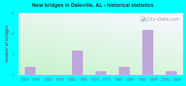
- New bridges - historical statistics
- 21940-1949
- 61960-1969
- 11970-1979
- 21980-1989
- 111990-1999
- 12000-2009


- Bridge Condition - Deck
- 30.8%Very good
- 38.5%Good
- 23.1%Satisfactory
- 7.7%Fair

- Bridge Condition - Superstructure
- 30.8%Very good
- 53.8%Good
- 15.4%Satisfactory

- Bridge Condition - Substructure
- 38.5%Very good
- 46.2%Good
- 15.4%Satisfactory

- Bridge Condition - Channel
- 19.0%Very good
- 47.6%Good
- 23.8%Satisfactory
- 9.5%Fair

- Bridge Condition - Culverts
- 10.0%Excellent
- 10.0%Very good
- 50.0%Good
- 30.0%Satisfactory
Find on map >> Show street view
Structure Number: 2757, Location: 2.5 MI. E. OF DALEVILLE (Lat: 31.310917, Lng: -85.682450), Route carried "on" structure: State highway 134, Year Built: 1943, Status: Open, Structure Length: 1.13m (3.71ft), Average Daily Traffic: 4,460 (year 2013), Truck Traffic: 5%, Average Future Daily Traffic: 6,422 (year 2033), Design Load: H 15, Features Intersected: STREAM
Minimum Vertical Clearance: 30+ m (98+ ft), Kilometerpoint: 60.317, Lanes on structure: 2, Owner: State Highway Agency, Approaching Roadway Width: 12.2m (40.0ft), Skew: 3 degrees, Material/Design: Concrete, Design/Construction: Culvert, Number Of Spans In Main Unit: 5, Length of Maximum Span: 2.1m (6.9ft)
Condition: Channel: Satisfactory, Culverts: Satisfactory, Operating Rating: 34.5 metric tons, Method Used To Determine Operating Rating: Load Factor (LF), Inventory Rating: 20.7 metric tons, Method Used To Determine Inventory Rating: Load Factor (LF), Structural Evaluation: Somewhat better than minimum adequacy, Waterway Adequacy: Equal to present desirable criteria, Approach Roadway Alignment: Equal to present desirable criteria, Length Of Structure Improvement: 1.80m (5.91ft), Designated Inspection Frequency: Every 24 months, Inspection Date: May 2021, Bridge Improvement Cost: $697,000, Roadway Improvement Cost: $70,000, Total Project Cost: $767,000 ( Estimate for 2022)
Find on map >> Show street view
Structure Number: 3775, Location: 1.25 MI SE OF BLUFF (Lat: 33.802689, Lng: -87.910669), Route carried "on" structure: County highway 107, Year Built: 1992, Status: Open, Structure Length: 0.98m (3.22ft), Average Daily Traffic: 60 (year 1996), Average Future Daily Traffic: 70 (year 2030), Design Load: HS 20, Features Intersected: HELL'S CREEK, Facility Carried by Structure: KIRKLAND RD.
Minimum Vertical Clearance: 30+ m (98+ ft), Kilometerpoint: 0.000, Lanes on structure: 2, Owner: County Highway Agency, Approaching Roadway Width: 8.5m (27.9ft), Material/Design: Concrete, Design/Construction: Culvert, Number Of Spans In Main Unit: 3, Length of Maximum Span: 3.0m (9.8ft)
Condition: Channel: Fair, Culverts: Good, Operating Rating: 56.2 metric tons, Method Used To Determine Operating Rating: Load Factor (LF), Inventory Rating: 33.6 metric tons, Method Used To Determine Inventory Rating: Load Factor (LF), Structural Evaluation: Better than present minimum criteria, Waterway Adequacy: Better than present minimum criteria, Approach Roadway Alignment: Equal to present desirable criteria, Length Of Structure Improvement: 1.66m (5.45ft), Designated Inspection Frequency: Every 24 months, Inspection Date: March 2021, Bridge Improvement Cost: $402,000, Roadway Improvement Cost: $40,000, Total Project Cost: $442,000 ( Estimate for 2022)
Find on map >> Show street view
Structure Number: 745, Location: SEC-33 T-4-N R-24-E (Lat: 31.272719, Lng: -85.647886), Route carried "on" structure: County highway 121, Year Built: 1961, Status: Posted for load, Structure Length: 7.74m (25.39ft), Average Daily Traffic: 121 (year 2005), Truck Traffic: 8%, Average Future Daily Traffic: 180 (year 2034), Design Load: H 15, Features Intersected: LITTLE CHOC RIVER
Minimum Vertical Clearance: 30+ m (98+ ft), Kilometerpoint: 0.000, Lanes on structure: 2, Owner: County Highway Agency, Approaching Roadway Width: 9.1m (29.9ft), Material/Design: Concrete, Design/Construction: Tee Beam, Number Of Spans In Main Unit: 7, Length of Maximum Span: 10.4m (34.1ft), Curb-To-Curb Width: 6.7m (22.0ft), Out-to-Out Width: 7.6m (24.9ft)
Condition: Deck: Satisfactory, Superstructure: Good, Substructure: Good, Channel: Good, Operating Rating: 35.7 metric tons, Method Used To Determine Operating Rating: Load Factor (LF), Inventory Rating: 21.4 metric tons, Method Used To Determine Inventory Rating: Load Factor (LF), Structural Evaluation: Equal to present minimum criteria, Deck Geometry: Meets minimum limits, Waterway Adequacy: Equal to present minimum criteria, Approach Roadway Alignment: Better than present minimum criteria, Bridge Posting: Required (Relationship of Operating Rating to Maximum Legal Load: 0.1 - 9.9% below), Length Of Structure Improvement: 8.75m (28.71ft), Designated Inspection Frequency: Every 24 months, Other Special Inspection Frequency: Every 12 months, Inspection Date: October 2021, Other Special Inspection Date: October 2021, Bridge Improvement Cost: $1,441,000, Roadway Improvement Cost: $144,000, Total Project Cost: $1,585,000 ( Estimate for 2022), Deck Structure Type: Concrete Cast-file-Place
Find on map >> Show street view
Structure Number: 9159, Location: 3 MI. E. OF DALEVILLE (Lat: 31.275617, Lng: -85.678950), Route carried "on" structure: US 84, Year Built: 1966, Status: Open, Structure Length: 15.21m (49.90ft), Average Daily Traffic: 9,165 (year 2013), Truck Traffic: 4%, Average Future Daily Traffic: 12,295 (year 2033), Design Load: HS 20, Features Intersected: CHOCTAWHATCHEE RIVER
Minimum Vertical Clearance: 30+ m (98+ ft), Kilometerpoint: 308.690, Lanes on structure: 2, Base Highway Network: Yes, Owner: State Highway Agency, Approaching Roadway Width: 12.2m (40.0ft), Material/Design: Steel continuous, Design/Construction: Stringer/Multi-beam, Number Of Spans In Main Unit: 3, Number Of Approach Spans: 7, Length of Maximum Span: 30.5m (100.1ft), Curb or Sidewalk Widths: Left: 0.5m (1.6ft), Right: 0.5m (1.6ft), Curb-To-Curb Width: 8.5m (27.9ft), Out-to-Out Width: 10.1m (33.1ft)
Condition: Deck: Fair, Superstructure: Good, Substructure: Good, Channel: Good, Operating Rating: 39.2 metric tons, Method Used To Determine Operating Rating: Load Factor (LF), Inventory Rating: 23.4 metric tons, Method Used To Determine Inventory Rating: Load Factor (LF), Structural Evaluation: Somewhat better than minimum adequacy, Deck Geometry: High priority of corrective action, Waterway Adequacy: Equal to present desirable criteria, Approach Roadway Alignment: Equal to present desirable criteria, Length Of Structure Improvement: 15.98m (52.43ft), Designated Inspection Frequency: Every 24 months, Inspection Date: March 2020, Bridge Improvement Cost: $3,616,000, Roadway Improvement Cost: $362,000, Total Project Cost: $3,978,000 ( Estimate for 2022), Deck Structure Type: Concrete Cast-file-Place
Find on map >> Show street view
Structure Number: 9677, Location: SEC-28 T-4-N R-23-E (Lat: 31.285453, Lng: -85.751511), Route carried "on" structure: County highway 24, Year Built: 1968, Status: Open, Structure Length: 1.10m (3.61ft), Average Daily Traffic: 1,406 (year 2006), Truck Traffic: 5%, Average Future Daily Traffic: 2,089 (year 2034), Design Load: H 15, Features Intersected: SNELL BRIDGE CREEK
Minimum Vertical Clearance: 7.56m (24.80ft), Kilometerpoint: 0.000, Lanes on structure: 2, Owner: County Highway Agency, Approaching Roadway Width: 9.1m (29.9ft), Skew: 4 degrees, Material/Design: Concrete, Design/Construction: Culvert, Number Of Spans In Main Unit: 2, Length of Maximum Span: 3.7m (12.1ft)
Condition: Channel: Satisfactory, Culverts: Satisfactory, Operating Rating: 62.6 metric tons, Method Used To Determine Operating Rating: Load Factor (LF), Inventory Rating: 37.6 metric tons, Method Used To Determine Inventory Rating: Load Factor (LF), Structural Evaluation: Equal to present minimum criteria, Waterway Adequacy: Equal to present minimum criteria, Approach Roadway Alignment: Better than present minimum criteria, Length Of Structure Improvement: 1.77m (5.81ft), Designated Inspection Frequency: Every 24 months, Inspection Date: June 2020, Bridge Improvement Cost: $666,000, Roadway Improvement Cost: $67,000, Total Project Cost: $733,000 ( Estimate for 2022)
Find on map >> Show street view
Structure Number: 9678, Location: SEC-27 T-4-N R-23-E (Lat: 31.285369, Lng: -85.738753), Route carried "on" structure: County highway 24, Year Built: 1968, Status: Open, Structure Length: 8.78m (28.81ft), Average Daily Traffic: 1,406 (year 2006), Truck Traffic: 8%, Average Future Daily Traffic: 2,089 (year 2034), Design Load: HS 20, Features Intersected: CLAYBANK CREEK
Minimum Vertical Clearance: 7.56m (24.80ft), Kilometerpoint: 0.000, Lanes on structure: 2, Owner: County Highway Agency, Approaching Roadway Width: 9.1m (29.9ft), Material/Design: Steel, Design/Construction: Stringer/Multi-beam, Number Of Spans In Main Unit: 1, Number Of Approach Spans: 7, Length of Maximum Span: 15.2m (49.9ft), Curb-To-Curb Width: 8.5m (27.9ft), Out-to-Out Width: 9.6m (31.5ft)
Condition: Deck: Good, Superstructure: Good, Substructure: Good, Channel: Satisfactory, Operating Rating: 50.5 metric tons, Method Used To Determine Operating Rating: Load Factor (LF), Inventory Rating: 30.4 metric tons, Method Used To Determine Inventory Rating: Load Factor (LF), Structural Evaluation: Better than present minimum criteria, Deck Geometry: Somewhat better than minimum adequacy, Waterway Adequacy: Better than present minimum criteria, Approach Roadway Alignment: Better than present minimum criteria, Length Of Structure Improvement: 9.76m (32.02ft), Designated Inspection Frequency: Every 24 months, Inspection Date: October 2021, Bridge Improvement Cost: $2,075,000, Roadway Improvement Cost: $208,000, Total Project Cost: $2,283,000 ( Estimate for 2022), Deck Structure Type: Concrete Cast-file-Place
Find on map >> Show street view
Structure Number: 9982, Location: 4.5 MI SW OF COFFEE SPRI (Lat: 31.096600, Lng: -85.934375), Route carried "on" structure: County highway 8, Year Built: 1969, Status: Open, Structure Length: 1.14m (3.74ft), Average Daily Traffic: 125 (year 2020), Truck Traffic: 4%, Average Future Daily Traffic: 150 (year 2040), Design Load: H 15, Features Intersected: LONG BRANCH
Minimum Vertical Clearance: 30+ m (98+ ft), Kilometerpoint: 0.010, Lanes on structure: 2, Owner: County Highway Agency, Approaching Roadway Width: 8.5m (27.9ft), Material/Design: Concrete, Design/Construction: Culvert, Number Of Spans In Main Unit: 3, Length of Maximum Span: 3.7m (12.1ft)
Condition: Channel: Good, Culverts: Good, Operating Rating: 88.9 metric tons, Method Used To Determine Operating Rating: Load Factor (LF), Inventory Rating: 88.9 metric tons, Method Used To Determine Inventory Rating: Load Factor (LF), Structural Evaluation: Better than present minimum criteria, Waterway Adequacy: Better than present minimum criteria, Approach Roadway Alignment: Better than present minimum criteria, Length Of Structure Improvement: 1.81m (5.94ft), Designated Inspection Frequency: Every 24 months, Inspection Date: July 2020, Bridge Improvement Cost: $554,000, Roadway Improvement Cost: $55,000, Total Project Cost: $609,000 ( Estimate for 2022)
Find on map >> Show street view
Structure Number: 9983, Location: 0.16 MI N OF PINEBROOK DR (Lat: 32.401392, Lng: -86.188333), Route carried "on" structure: City street , Year Built: 1969, Status: Open, Structure Length: 7.32m (24.02ft), Average Daily Traffic: 2,800 (year 2006), Truck Traffic: 1%, Average Future Daily Traffic: 3,920 (year 2038), Design Load: H 15, Features Intersected: MONTGOMERY EAST DITCH, Facility Carried by Structure: WARES FERRY RD
Minimum Vertical Clearance: 30+ m (98+ ft), Kilometerpoint: 4.199, Lanes on structure: 2, Owner: City or Municipal Highway Agency, Approaching Roadway Width: 13.4m (44.0ft), Material/Design: Concrete, Design/Construction: Channel Beam, Number Of Spans In Main Unit: 10, Length of Maximum Span: 7.3m (24.0ft), Curb-To-Curb Width: 7.3m (24.0ft), Out-to-Out Width: 8.4m (27.6ft)
Condition: Deck: Satisfactory, Superstructure: Satisfactory, Substructure: Satisfactory, Channel: Satisfactory, Operating Rating: 49.6 metric tons, Method Used To Determine Operating Rating: Load Factor (LF), Inventory Rating: 29.8 metric tons, Method Used To Determine Inventory Rating: Load Factor (LF), Structural Evaluation: Equal to present minimum criteria, Deck Geometry: High priority of replacement, Waterway Adequacy: Equal to present minimum criteria, Approach Roadway Alignment: Better than present minimum criteria, Length Of Structure Improvement: 8.35m (27.40ft), Designated Inspection Frequency: Every 24 months, Inspection Date: September 2020, Bridge Improvement Cost: $1,545,000, Roadway Improvement Cost: $155,000, Total Project Cost: $1,700,000 ( Estimate for 2022), Deck Structure Type: Concrete Precast Panels, Wearing Surface/Protective System: Wearing Surface: Bituminous
Find on map >> Show street view
Structure Number: 11476, Location: FORT RUCKER GATE (Lat: 31.321467, Lng: -85.710433), Route carried "on" structure: State highway 85, Year Built: 1975, Status: Open, Structure Length: 3.96m (12.99ft), Average Daily Traffic: 11,910 (year 2013), Truck Traffic: 3%, Average Future Daily Traffic: 15,978 (year 2033), Design Load: HS 20, Features Intersected: WIREGRASS CENTRAL R.R.
Minimum Vertical Clearance: 30+ m (98+ ft), Kilometerpoint: 35.876, Lanes on structure: 5, Owner: State Highway Agency, Approaching Roadway Width: 19.5m (64.0ft), Skew: 2 degrees, Material/Design: Steel, Design/Construction: Stringer/Multi-beam, Number Of Spans In Main Unit: 1, Number Of Approach Spans: 2, Length of Maximum Span: 18.9m (62.0ft), Curb or Sidewalk Widths: Left: 1.5m (4.9ft), Right: 1.5m (4.9ft), Curb-To-Curb Width: 19.5m (64.0ft), Out-to-Out Width: 23.2m (76.1ft)
Condition: Deck: Good, Superstructure: Good, Substructure: Good, Operating Rating: 48.4 metric tons, Method Used To Determine Operating Rating: Load Factor (LF), Inventory Rating: 29.0 metric tons, Method Used To Determine Inventory Rating: Load Factor (LF), Structural Evaluation: Better than present minimum criteria, Deck Geometry: Meets minimum limits, Underclear: Somewhat better than minimum adequacy, Approach Roadway Alignment: Equal to present desirable criteria, Length Of Structure Improvement: 4.91m (16.11ft), Designated Inspection Frequency: Every 24 months, Inspection Date: March 2021, Bridge Improvement Cost: $2,558,000, Roadway Improvement Cost: $256,000, Total Project Cost: $2,814,000 ( Estimate for 2022), Deck Structure Type: Concrete Cast-file-Place
Find on map >> Show street view
Structure Number: 1338, Location: JCT. DALE CO. 114 (Lat: 31.308114, Lng: -85.743336), Route carried "on" structure: State highway 37, Year Built: 1984, Status: Open, Structure Length: 0.69m (2.26ft), Average Daily Traffic: 3,400 (year 2013), Truck Traffic: 3%, Average Future Daily Traffic: 4,472 (year 2033), Design Load: HS 20, Features Intersected: LITTLE CLAYBANK CREEK
Minimum Vertical Clearance: 30+ m (98+ ft), Kilometerpoint: 0.491, Lanes on structure: 2, Owner: State Highway Agency, Approaching Roadway Width: 12.2m (40.0ft), Skew: 4 degrees, Material/Design: Concrete, Design/Construction: Culvert, Number Of Spans In Main Unit: 2, Length of Maximum Span: 2.4m (7.9ft)
Condition: Channel: Good, Culverts: Good, Operating Rating: 88.9 metric tons, Method Used To Determine Operating Rating: Load Factor (LF), Inventory Rating: 83.7 metric tons, Method Used To Determine Inventory Rating: Load Factor (LF), Structural Evaluation: Better than present minimum criteria, Waterway Adequacy: Equal to present desirable criteria, Approach Roadway Alignment: Equal to present desirable criteria, Length Of Structure Improvement: 1.33m (4.36ft), Designated Inspection Frequency: Every 24 months, Inspection Date: Febuary 2021, Bridge Improvement Cost: $747,000, Roadway Improvement Cost: $75,000, Total Project Cost: $822,000 ( Estimate for 2022), Wearing Surface/Protective System: Wearing Surface: Bituminous
Find on map >> Show street view
Structure Number: 13381, Location: 1 MI. W. SR 85 (Lat: 31.305683, Lng: -85.743600), Route carried "on" structure: US 84, Year Built: 1984, Status: Open, Structure Length: 20.42m (66.99ft), Average Daily Traffic: 9,465 (year 2013), Truck Traffic: 4%, Average Future Daily Traffic: 12,698 (year 2033), Design Load: HS 20, Features Intersected: CLAYBANK CREEK
Minimum Vertical Clearance: 30+ m (98+ ft), Kilometerpoint: 301.556, Lanes on structure: 2, Base Highway Network: Yes, Owner: State Highway Agency, Approaching Roadway Width: 13.4m (44.0ft), Material/Design: Steel continuous, Design/Construction: Stringer/Multi-beam, Number Of Spans In Main Unit: 3, Number Of Approach Spans: 12, Length of Maximum Span: 30.5m (100.1ft), Curb-To-Curb Width: 13.4m (44.0ft), Out-to-Out Width: 14.3m (46.9ft)
Condition: Deck: Good, Superstructure: Good, Substructure: Good, Channel: Fair, Operating Rating: 57.2 metric tons, Method Used To Determine Operating Rating: Load Factor (LF), Inventory Rating: 34.3 metric tons, Method Used To Determine Inventory Rating: Load Factor (LF), Structural Evaluation: Better than present minimum criteria, Deck Geometry: Superior to present desirable criteria, Waterway Adequacy: Equal to present desirable criteria, Approach Roadway Alignment: Equal to present desirable criteria, Length Of Structure Improvement: 20.42m (66.99ft), Designated Inspection Frequency: Every 24 months, Inspection Date: March 2020, Bridge Improvement Cost: $6,441,000, Roadway Improvement Cost: $644,000, Total Project Cost: $7,085,000 ( Estimate for 2022), Deck Structure Type: Concrete Cast-file-Place
Find on map >> Show street view
Structure Number: 15122, Location: DALEVILLE (Lat: 31.285000, Lng: -85.758333), Route carried "on" structure: City street , Year Built: 1990, Status: Open, Structure Length: 1.04m (3.41ft), Average Daily Traffic: 100 (year 1996), Average Future Daily Traffic: 150 (year 2034), Design Load: HS 20, Features Intersected: LITTLE CLAYBANK CREEK, Facility Carried by Structure: BRUER DRIVE
Minimum Vertical Clearance: 30+ m (98+ ft), Kilometerpoint: 0.200, Lanes on structure: 2, Owner: City or Municipal Highway Agency, Approaching Roadway Width: 8.5m (27.9ft), Material/Design: Concrete, Design/Construction: Channel Beam, Number Of Spans In Main Unit: 1, Length of Maximum Span: 10.4m (34.1ft), Curb or Sidewalk Widths: Left: 0.2m (0.7ft), Right: 0.2m (0.7ft), Curb-To-Curb Width: 7.3m (24.0ft), Out-to-Out Width: 8.2m (26.9ft)
Condition: Deck: Very good, Superstructure: Very good, Substructure: Very good, Channel: Very good, Operating Rating: 67.6 metric tons, Method Used To Determine Operating Rating: Load Factor (LF), Inventory Rating: 40.6 metric tons, Method Used To Determine Inventory Rating: Load Factor (LF), Structural Evaluation: Equal to present desirable criteria, Deck Geometry: Equal to present minimum criteria, Waterway Adequacy: Equal to present minimum criteria, Approach Roadway Alignment: Better than present minimum criteria, Length Of Structure Improvement: 1.71m (5.61ft), Designated Inspection Frequency: Every 24 months, Inspection Date: December 2020, Bridge Improvement Cost: $305,000, Roadway Improvement Cost: $31,000, Total Project Cost: $336,000 ( Estimate for 2022), Deck Structure Type: Concrete Precast Panels
Find on map >> Show street view
Structure Number: 15934, Location: DALE-HOUSTON CO.LINE (Lat: 31.262817, Lng: -85.668650), Route carried "on" structure: US 84, Year Built: 1994, Status: Open, Structure Length: 8.38m (27.49ft), Average Daily Traffic: 9,165 (year 2013), Truck Traffic: 4%, Average Future Daily Traffic: 12,295 (year 2033), Design Load: HS 20, Features Intersected: LITTLE CHOCTAWHATCHEE R.
Minimum Vertical Clearance: 30+ m (98+ ft), Kilometerpoint: 310.420, Lanes on structure: 2, Base Highway Network: Yes, Owner: State Highway Agency, Approaching Roadway Width: 12.2m (40.0ft), Material/Design: Prestressed concrete, Design/Construction: Stringer/Multi-beam, Number Of Spans In Main Unit: 1, Number Of Approach Spans: 2, Length of Maximum Span: 35.1m (115.2ft), Curb-To-Curb Width: 12.2m (40.0ft), Out-to-Out Width: 13.0m (42.7ft)
Condition: Deck: Very good, Superstructure: Good, Substructure: Very good, Channel: Good, Operating Rating: 77.9 metric tons, Method Used To Determine Operating Rating: Load Factor (LF), Inventory Rating: 44.9 metric tons, Method Used To Determine Inventory Rating: Load Factor (LF), Structural Evaluation: Better than present minimum criteria, Deck Geometry: Better than present minimum criteria, Waterway Adequacy: Equal to present desirable criteria, Approach Roadway Alignment: Equal to present desirable criteria, Length Of Structure Improvement: 9.38m (30.77ft), Designated Inspection Frequency: Every 24 months, Inspection Date: March 2020, Bridge Improvement Cost: $2,700,000, Roadway Improvement Cost: $270,000, Total Project Cost: $2,970,000 ( Estimate for 2022), Deck Structure Type: Concrete Cast-file-Place
Find on map >> Show street view
Structure Number: 15935, Location: 3 MI.E. OF DALEVILLE (Lat: 31.275800, Lng: -85.678767), Route carried "on" structure: US 84, Year Built: 1994, Status: Open, Structure Length: 16.22m (53.22ft), Average Daily Traffic: 9,165 (year 2013), Truck Traffic: 4%, Average Future Daily Traffic: 12,295 (year 2033), Design Load: HS 20, Features Intersected: CHOCTAWHATCHEE RIVER
Minimum Vertical Clearance: 30+ m (98+ ft), Kilometerpoint: 308.690, Lanes on structure: 2, Base Highway Network: Yes, Owner: State Highway Agency, Approaching Roadway Width: 13.7m (44.9ft), Material/Design: Prestressed concrete, Design/Construction: Stringer/Multi-beam, Number Of Spans In Main Unit: 3, Number Of Approach Spans: 8, Length of Maximum Span: 30.5m (100.1ft), Curb-To-Curb Width: 12.2m (40.0ft), Out-to-Out Width: 13.0m (42.7ft)
Condition: Deck: Good, Superstructure: Very good, Substructure: Very good, Channel: Good, Operating Rating: 59.9 metric tons, Method Used To Determine Operating Rating: Load Factor (LF), Inventory Rating: 35.8 metric tons, Method Used To Determine Inventory Rating: Load Factor (LF), Structural Evaluation: Equal to present desirable criteria, Deck Geometry: Better than present minimum criteria, Waterway Adequacy: Superior to present desirable criteria, Approach Roadway Alignment: Superior to present desirable criteria, Length Of Structure Improvement: 16.96m (55.64ft), Designated Inspection Frequency: Every 24 months, Inspection Date: March 2020, Bridge Improvement Cost: $4,885,000, Roadway Improvement Cost: $489,000, Total Project Cost: $5,374,000 ( Estimate for 2022), Deck Structure Type: Concrete Cast-file-Place
Find on map >> Show street view
Structure Number: 15936, Location: 2.5 MI E.OF DALEVILLE (Lat: 31.279167, Lng: -85.684517), Route carried "on" structure: US 84, Year Built: 1993, Status: Open, Structure Length: 1.10m (3.61ft), Average Daily Traffic: 9,165 (year 2013), Truck Traffic: 4%, Average Future Daily Traffic: 12,295 (year 2033), Design Load: HS 20, Features Intersected: BRANCH
Minimum Vertical Clearance: 30+ m (98+ ft), Kilometerpoint: 308.014, Lanes on structure: 2, Base Highway Network: Yes, Owner: State Highway Agency, Approaching Roadway Width: 14.0m (45.9ft), Skew: 3 degrees, Material/Design: Concrete, Design/Construction: Culvert, Number Of Spans In Main Unit: 3, Length of Maximum Span: 3.5m (11.5ft)
Condition: Channel: Good, Culverts: Satisfactory, Operating Rating: 88.9 metric tons, Method Used To Determine Operating Rating: Load Factor (LF), Inventory Rating: 88.9 metric tons, Method Used To Determine Inventory Rating: Load Factor (LF), Structural Evaluation: Equal to present minimum criteria, Waterway Adequacy: Equal to present desirable criteria, Approach Roadway Alignment: Equal to present desirable criteria, Length Of Structure Improvement: 1.77m (5.81ft), Designated Inspection Frequency: Every 24 months, Inspection Date: March 2020, Bridge Improvement Cost: $1,778,000, Roadway Improvement Cost: $178,000, Total Project Cost: $1,956,000 ( Estimate for 2022)
Find on map >> Show street view
Structure Number: 16039, Location: 2.5 MI.E.OF DALEVILLE (Lat: 31.278683, Lng: -85.685117), Route carried "on" structure: US 84, Year Built: 1995, Status: Open, Structure Length: 1.24m (4.07ft), Average Daily Traffic: 9,165 (year 2013), Truck Traffic: 4%, Average Future Daily Traffic: 12,295 (year 2033), Design Load: HS 20, Features Intersected: BRANCH
Minimum Vertical Clearance: 30+ m (98+ ft), Kilometerpoint: 308.014, Lanes on structure: 2, Base Highway Network: Yes, Owner: State Highway Agency, Approaching Roadway Width: 17.1m (56.1ft), Skew: 2 degrees, Material/Design: Concrete, Design/Construction: Culvert, Number Of Spans In Main Unit: 4, Length of Maximum Span: 2.7m (8.9ft)
Condition: Channel: Satisfactory, Culverts: Good, Operating Rating: 88.9 metric tons, Method Used To Determine Operating Rating: Load Factor (LF), Inventory Rating: 88.9 metric tons, Method Used To Determine Inventory Rating: Load Factor (LF), Structural Evaluation: Better than present minimum criteria, Waterway Adequacy: Equal to present desirable criteria, Approach Roadway Alignment: Equal to present desirable criteria, Length Of Structure Improvement: 1.92m (6.30ft), Designated Inspection Frequency: Every 24 months, Inspection Date: March 2020, Bridge Improvement Cost: $1,308,000, Roadway Improvement Cost: $131,000, Total Project Cost: $1,439,000 ( Estimate for 2022)
Find on map >> Show street view
Structure Number: 16109, Location: DALE-HOUSTON CO. LINE (Lat: 31.262683, Lng: -85.668800), Route carried "on" structure: US 84, Year Built: 1994, Status: Open, Structure Length: 8.38m (27.49ft), Average Daily Traffic: 9,165 (year 2013), Truck Traffic: 4%, Average Future Daily Traffic: 12,295 (year 2033), Design Load: HS 20, Features Intersected: LITTLE CHOCTAWHATCHEE R.
Minimum Vertical Clearance: 30+ m (98+ ft), Kilometerpoint: 310.420, Lanes on structure: 2, Base Highway Network: Yes, Owner: State Highway Agency, Approaching Roadway Width: 12.2m (40.0ft), Material/Design: Prestressed concrete, Design/Construction: Stringer/Multi-beam, Number Of Spans In Main Unit: 1, Number Of Approach Spans: 2, Length of Maximum Span: 35.1m (115.2ft), Curb-To-Curb Width: 9.9m (32.5ft), Out-to-Out Width: 13.0m (42.7ft)
Condition: Deck: Very good, Superstructure: Good, Substructure: Very good, Channel: Good, Operating Rating: 77.6 metric tons, Method Used To Determine Operating Rating: Load Factor (LF), Inventory Rating: 43.6 metric tons, Method Used To Determine Inventory Rating: Load Factor (LF), Structural Evaluation: Better than present minimum criteria, Deck Geometry: Meets minimum limits, Waterway Adequacy: Equal to present desirable criteria, Approach Roadway Alignment: Equal to present desirable criteria, Length Of Structure Improvement: 9.38m (30.77ft), Designated Inspection Frequency: Every 24 months, Inspection Date: March 2020, Bridge Improvement Cost: $2,700,000, Roadway Improvement Cost: $270,000, Total Project Cost: $2,970,000 ( Estimate for 2022), Deck Structure Type: Concrete Cast-file-Place
Find on map >> Show street view
Structure Number: 16111, Location: 3.6 MI.E.OF DALEVILLE (Lat: 31.312967, Lng: -85.672550), Route carried "on" structure: State highway 134, Year Built: 1994, Status: Open, Structure Length: 3.75m (12.30ft), Average Daily Traffic: 4,460 (year 2013), Truck Traffic: 4%, Average Future Daily Traffic: 6,422 (year 2033), Design Load: HS 20, Features Intersected: DILLY BRANCH
Minimum Vertical Clearance: 30+ m (98+ ft), Kilometerpoint: 61.281, Lanes on structure: 2, Owner: State Highway Agency, Approaching Roadway Width: 12.2m (40.0ft), Material/Design: Prestressed concrete continuous, Design/Construction: Stringer/Multi-beam, Number Of Spans In Main Unit: 3, Length of Maximum Span: 12.5m (41.0ft), Curb-To-Curb Width: 12.2m (40.0ft), Out-to-Out Width: 13.1m (43.0ft)
Condition: Deck: Good, Superstructure: Very good, Substructure: Good, Channel: Good, Operating Rating: 47.1 metric tons, Method Used To Determine Operating Rating: Load Factor (LF), Inventory Rating: 26.7 metric tons, Method Used To Determine Inventory Rating: Load Factor (LF), Structural Evaluation: Equal to present minimum criteria, Deck Geometry: Equal to present minimum criteria, Waterway Adequacy: Equal to present desirable criteria, Approach Roadway Alignment: Equal to present desirable criteria, Length Of Structure Improvement: 4.68m (15.35ft), Designated Inspection Frequency: Every 24 months, Inspection Date: May 2021, Bridge Improvement Cost: $1,380,000, Roadway Improvement Cost: $138,000, Total Project Cost: $1,518,000 ( Estimate for 2022), Deck Structure Type: Concrete Cast-file-Place
Find on map >> Show street view
Structure Number: 16234, Location: 3.8 MI. E. OF DALEVILLE (Lat: 31.316017, Lng: -85.661783), Route carried "on" structure: State highway 134, Year Built: 1995, Status: Open, Structure Length: 6.40m (21.00ft), Average Daily Traffic: 4,460 (year 2013), Truck Traffic: 4%, Average Future Daily Traffic: 6,422 (year 2033), Design Load: HS 20, Features Intersected: KELLY MILL CREEK
Minimum Vertical Clearance: 30+ m (98+ ft), Kilometerpoint: 62.309, Lanes on structure: 2, Owner: State Highway Agency, Approaching Roadway Width: 10.7m (35.1ft), Skew: 3 degrees, Material/Design: Prestressed concrete, Design/Construction: Stringer/Multi-beam, Number Of Spans In Main Unit: 3, Length of Maximum Span: 21.3m (69.9ft), Curb-To-Curb Width: 12.2m (40.0ft), Out-to-Out Width: 13.0m (42.7ft)
Condition: Deck: Very good, Superstructure: Very good, Substructure: Very good, Channel: Very good, Operating Rating: 83.8 metric tons, Method Used To Determine Operating Rating: Load Factor (LF), Inventory Rating: 47.0 metric tons, Method Used To Determine Inventory Rating: Load Factor (LF), Structural Evaluation: Equal to present desirable criteria, Deck Geometry: Equal to present minimum criteria, Waterway Adequacy: Equal to present desirable criteria, Approach Roadway Alignment: Equal to present desirable criteria, Length Of Structure Improvement: 7.44m (24.41ft), Designated Inspection Frequency: Every 24 months, Inspection Date: May 2021, Bridge Improvement Cost: $2,143,000, Roadway Improvement Cost: $214,000, Total Project Cost: $2,357,000 ( Estimate for 2022), Deck Structure Type: Concrete Cast-file-Place
Find on map >> Show street view
Structure Number: 16258, Location: TANK HILL GATE, FT RUCKER (Lat: 31.314164, Lng: -85.733203), Route carried "on" structure: US 37, Year Built: 1943, Status: Posted for load, Structure Length: 3.20m (10.50ft), Average Daily Traffic: 80 (year 2013), Truck Traffic: 3%, Average Future Daily Traffic: 105 (year 2033), Design Load: H 15, Features Intersected: WIREGRASS CENTRAL RR
Minimum Vertical Clearance: 30+ m (98+ ft), Kilometerpoint: 1.204, Lanes on structure: 2, Owner: State Highway Agency, Approaching Roadway Width: 11.0m (36.1ft), Skew: 1 degrees, Material/Design: Wood or Timber, Design/Construction: Stringer/Multi-beam, Number Of Spans In Main Unit: 5, Length of Maximum Span: 7.3m (24.0ft), Curb or Sidewalk Widths: Left: 0.5m (1.6ft), Right: 0.5m (1.6ft), Curb-To-Curb Width: 7.2m (23.6ft), Out-to-Out Width: 8.9m (29.2ft)
Condition: Deck: Satisfactory, Superstructure: Satisfactory, Substructure: Satisfactory, Operating Rating: 37.4 metric tons, Method Used To Determine Operating Rating: Allowable Stress (AS), Inventory Rating: 19.7 metric tons, Method Used To Determine Inventory Rating: Allowable Stress (AS), Structural Evaluation: Somewhat better than minimum adequacy, Deck Geometry: Somewhat better than minimum adequacy, Approach Roadway Alignment: Equal to present desirable criteria, Bridge Posting: Required (Relationship of Operating Rating to Maximum Legal Load: 20.0 - 29.9% below), Length Of Structure Improvement: 4.07m (13.35ft), Designated Inspection Frequency: Every 24 months, Other Special Inspection Frequency: Every 12 months, Inspection Date: Febuary 2022, Other Special Inspection Date: Febuary 2022, Bridge Improvement Cost: $808,000, Roadway Improvement Cost: $81,000, Total Project Cost: $889,000 ( Estimate for 2022), Deck Structure Type: Concrete Cast-file-Place
Find on map >> Show street view
Structure Number: 16671, Location: SEC 29, T4N, R4E (Lat: 31.286417, Lng: -85.659431), Route carried "on" structure: County highway 31, Year Built: 1996, Status: Open, Structure Length: 1.17m (3.84ft), Average Daily Traffic: 612 (year 2007), Truck Traffic: 5%, Average Future Daily Traffic: 909 (year 2034), Design Load: H 20, Features Intersected: HWY 31
Minimum Vertical Clearance: 7.56m (24.80ft), Kilometerpoint: 0.000, Lanes on structure: 2, Owner: County Highway Agency, Approaching Roadway Width: 9.1m (29.9ft), Material/Design: Concrete, Design/Construction: Culvert, Number Of Spans In Main Unit: 3, Length of Maximum Span: 3.7m (12.1ft)
Condition: Channel: Very good, Culverts: Very good, Operating Rating: 58.2 metric tons, Method Used To Determine Operating Rating: Load Factor (LF), Inventory Rating: 34.8 metric tons, Method Used To Determine Inventory Rating: Load Factor (LF), Structural Evaluation: Equal to present desirable criteria, Waterway Adequacy: Equal to present minimum criteria, Approach Roadway Alignment: Better than present minimum criteria, Length Of Structure Improvement: 1.85m (6.07ft), Designated Inspection Frequency: Every 24 months, Inspection Date: May 2020, Bridge Improvement Cost: $449,000, Roadway Improvement Cost: $45,000, Total Project Cost: $494,000 ( Estimate for 2022)
Find on map >> Show street view
Structure Number: 16672, Location: SEC 17, T3N, R23E (Lat: 31.228692, Lng: -85.769728), Route carried "on" structure: County highway 26, Year Built: 1996, Status: Open, Structure Length: 1.13m (3.71ft), Average Daily Traffic: 167 (year 2006), Truck Traffic: 2%, Average Future Daily Traffic: 248 (year 2034), Design Load: H 15, Features Intersected: BRACKIN MILL CREEK
Minimum Vertical Clearance: 30+ m (98+ ft), Kilometerpoint: 0.000, Lanes on structure: 2, Owner: County Highway Agency, Approaching Roadway Width: 7.9m (25.9ft), Skew: 3 degrees, Material/Design: Concrete, Design/Construction: Culvert, Number Of Spans In Main Unit: 3, Length of Maximum Span: 3.7m (12.1ft)
Condition: Channel: Very good, Culverts: Excellent, Operating Rating: 88.9 metric tons, Method Used To Determine Operating Rating: Load Factor (LF), Inventory Rating: 88.9 metric tons, Method Used To Determine Inventory Rating: Load Factor (LF), Structural Evaluation: Superior to present desirable criteria, Waterway Adequacy: Equal to present minimum criteria, Approach Roadway Alignment: Better than present minimum criteria, Length Of Structure Improvement: 1.81m (5.94ft), Designated Inspection Frequency: Every 24 months, Inspection Date: June 2020, Bridge Improvement Cost: $678,000, Roadway Improvement Cost: $68,000, Total Project Cost: $746,000 ( Estimate for 2022)
Find on map >> Show street view
Structure Number: 1859, Location: R-23-E T-4-N SEC-22 (Lat: 31.310192, Lng: -85.735861), Route carried "on" structure: Spur County highway 114, Year Built: 2001, Status: Open, Structure Length: 1.06m (3.48ft), Average Daily Traffic: 4,340 (year 2001), Truck Traffic: 10%, Average Future Daily Traffic: 6,080 (year 2034), Design Load: H 20, Features Intersected: SPUR OFF CLAY BANK CREEK
Minimum Vertical Clearance: 30+ m (98+ ft), Kilometerpoint: 0.000, Lanes on structure: 2, Owner: County Highway Agency, Approaching Roadway Width: 7.3m (24.0ft), Skew: 4 degrees, Material/Design: Concrete, Design/Construction: Culvert, Number Of Spans In Main Unit: 2, Length of Maximum Span: 3.7m (12.1ft)
Condition: Channel: Good, Culverts: Good, Operating Rating: 61.8 metric tons, Method Used To Determine Operating Rating: Load Factor (LF), Inventory Rating: 37.1 metric tons, Method Used To Determine Inventory Rating: Load Factor (LF), Structural Evaluation: Better than present minimum criteria, Waterway Adequacy: Better than present minimum criteria, Approach Roadway Alignment: Better than present minimum criteria, Length Of Structure Improvement: 1.74m (5.71ft), Designated Inspection Frequency: Every 24 months, Inspection Date: May 2020, Bridge Improvement Cost: $601,000, Roadway Improvement Cost: $60,000, Total Project Cost: $661,000 ( Estimate for 2022)