Bridge Statistics for Daleville, Indiana (IN)
Condition, Traffic, Stress, Structural Evaluation, Project Costs
- National Bridge Inventory (NBI) Statistics
- 29Number of bridges
- 203ft / 62.4mTotal length
- $1,549,000Total costs
- 278,141Total average daily traffic
- 54,900Total average daily truck traffic
- National Bridge Inventory (NBI) Registered Bridges for Daleville
- No street view available for this location
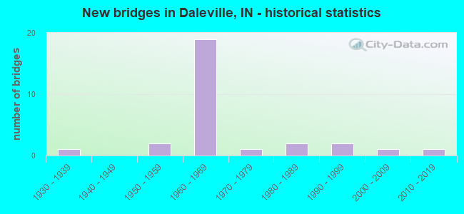
- New bridges - historical statistics
- 11930-1939
- 21950-1959
- 191960-1969
- 11970-1979
- 21980-1989
- 21990-1999
- 12000-2009
- 12010-2019

- Reconstructed bridges - Historical Statistics
- 31990-1999
- 12000-2009
- 12010-2019


- Bridge Condition - Deck
- 41.7%Good
- 50.0%Satisfactory
- 8.3%Fair

- Bridge Condition - Superstructure
- 41.7%Good
- 33.3%Satisfactory
- 25.0%Fair

- Bridge Condition - Substructure
- 16.7%Very good
- 41.7%Good
- 8.3%Satisfactory
- 33.3%Fair

- Bridge Condition - Channel
- 33.3%Very good
- 22.2%Good
- 22.2%Satisfactory
- 22.2%Fair
Find on map >> Show street view
Structure Number: 2891, Location: 00.48 W US 41 (Lat: 41.144869, Lng: -87.462669), Route carried "on" structure: State highway 10, Year Built: 2018, Status: Open, Structure Length: 2.96m (9.71ft), Average Daily Traffic: 3,638 (year 2020), Truck Traffic: 38%, Average Future Daily Traffic: 5,110 (year 2037), Design Load: HL 93, Features Intersected: BEAVER LAKE DITCH
Minimum Vertical Clearance: 30+ m (98+ ft), Kilometerpoint: 5.649, Lanes on structure: 2, Owner: State Highway Agency, Approaching Roadway Width: 12.2m (40.0ft), Material/Design: Concrete, Design/Construction: Slab, Number Of Spans In Main Unit: 2, Length of Maximum Span: 14.5m (47.6ft), Curb-To-Curb Width: 12.0m (39.4ft), Out-to-Out Width: 12.9m (42.3ft)
Condition: Deck: Good, Superstructure: Good, Substructure: Very good, Channel: Very good, Operating Rating: 77.8 metric tons, Method Used To Determine Operating Rating: Load and Resistance Factor Rating (LRFR) rating reported by rating factor(RF) method using HL-93 loadings, Inventory Rating: 60.3 metric tons, Method Used To Determine Inventory Rating: Load and Resistance Factor Rating (LRFR) rating reported by rating factor(RF) method using HL-93 loadings, Structural Evaluation: Better than present minimum criteria, Deck Geometry: Somewhat better than minimum adequacy, Waterway Adequacy: Equal to present desirable criteria, Approach Roadway Alignment: Equal to present desirable criteria, Designated Inspection Frequency: Every 24 months, Inspection Date: January 2022, Deck Structure Type: Concrete Cast-file-Place, Wearing Surface/Protective System: Wearing Surface: Monolithic Concrete, Deck Protection: Epoxy Coated Reinforcing
Find on map >> Show street view
Structure Number: 2025, Location: 00.53 W US 31 (Lat: 38.685461, Lng: -85.788089), Route carried "on" structure: State highway 56, Year Built: 1959, Year Reconstructed: 2000, Status: Open, Structure Length: 6.80m (22.31ft), Average Daily Traffic: 19,188 (year 2004), Truck Traffic: 10%, Average Future Daily Traffic: 27,471 (year 2030), Design Load: HS 20, Features Intersected: I-65 NB/SB
Minimum Vertical Clearance: 30+ m (98+ ft), Kilometerpoint: 8.771, Lanes on structure: 4, Lanes under structure: 5, Owner: State Highway Agency, Approaching Roadway Width: 26.8m (87.9ft), Skew: 20 degrees, Material/Design: Steel continuous, Design/Construction: Stringer/Multi-beam, Number Of Spans In Main Unit: 4, Length of Maximum Span: 21.5m (70.5ft), Curb-To-Curb Width: 26.8m (87.9ft), Out-to-Out Width: 28.9m (94.8ft)
Condition: Deck: Good, Superstructure: Good, Substructure: Fair, Operating Rating: 52.5 metric tons, Method Used To Determine Operating Rating: Load and Resistance Factor Rating (LRFR) rating reported by rating factor(RF) method using HL-93 loadings, Inventory Rating: 40.5 metric tons, Method Used To Determine Inventory Rating: Load and Resistance Factor Rating (LRFR) rating reported by rating factor(RF) method using HL-93 loadings, Structural Evaluation: Somewhat better than minimum adequacy, Deck Geometry: Superior to present desirable criteria, Underclear: Equal to present minimum criteria, Approach Roadway Alignment: Equal to present desirable criteria, Designated Inspection Frequency: Every 24 months, Inspection Date: March 2021, Deck Structure Type: Concrete Cast-file-Place, Wearing Surface/Protective System: Wearing Surface: Monolithic Concrete, Deck Protection: Epoxy Coated Reinforcing
Find on map >> Show street view
Structure Number: 2033, Location: 00.80 W SR 7 (Lat: 38.741831, Lng: -85.406814), Route carried "on" structure: State highway 56, Year Built: 1987, Status: Open, Structure Length: 6.95m (22.80ft), Average Daily Traffic: 8,065 (year 2004), Truck Traffic: 5%, Average Future Daily Traffic: 11,506 (year 2033), Design Load: HS 20, Features Intersected: CROOKED CREEK
Minimum Vertical Clearance: 30+ m (98+ ft), Kilometerpoint: 22.370, Lanes on structure: 2, Owner: State Highway Agency, Approaching Roadway Width: 14.0m (45.9ft), Skew: 2 degrees, Material/Design: Prestressed concrete continuous, Design/Construction: Stringer/Multi-beam, Number Of Spans In Main Unit: 3, Length of Maximum Span: 22.9m (75.1ft), Curb-To-Curb Width: 13.4m (44.0ft), Out-to-Out Width: 14.3m (46.9ft)
Condition: Deck: Satisfactory, Superstructure: Satisfactory, Substructure: Good, Channel: Good, Operating Rating: 59.7 metric tons, Method Used To Determine Operating Rating: Load Factor (LF), Inventory Rating: 30.1 metric tons, Method Used To Determine Inventory Rating: Load Factor (LF), Structural Evaluation: Equal to present minimum criteria, Deck Geometry: Equal to present minimum criteria, Waterway Adequacy: Equal to present desirable criteria, Approach Roadway Alignment: Equal to present desirable criteria, Designated Inspection Frequency: Every 24 months, Inspection Date: August 2020, Deck Structure Type: Concrete Cast-file-Place, Wearing Surface/Protective System: Wearing Surface: Monolithic Concrete, Deck Protection: Epoxy Coated Reinforcing
Find on map >> Show street view
Structure Number: 2034, Location: 00.18 W SR 7 (Lat: 38.739331, Lng: -85.396150), Route carried "on" structure: State highway 56, Year Built: 1976, Status: Open, Structure Length: 4.63m (15.19ft), Average Daily Traffic: 8,962 (year 2004), Truck Traffic: 5%, Average Future Daily Traffic: 12,779 (year 2030), Design Load: HS 20, Features Intersected: ABANDONED RR
Minimum Vertical Clearance: 30+ m (98+ ft), Kilometerpoint: 23.368, Lanes on structure: 2, Owner: State Highway Agency, Approaching Roadway Width: 12.2m (40.0ft), Skew: 1 degrees, Material/Design: Steel continuous, Design/Construction: Stringer/Multi-beam, Number Of Spans In Main Unit: 3, Length of Maximum Span: 19.5m (64.0ft), Curb or Sidewalk Widths: Left: 1.5m (4.9ft), Right: 1.5m (4.9ft), Curb-To-Curb Width: 12.2m (40.0ft), Out-to-Out Width: 17.0m (55.8ft)
Condition: Deck: Fair, Superstructure: Fair, Substructure: Good, Operating Rating: 41.1 metric tons, Method Used To Determine Operating Rating: Load and Resistance Factor Rating (LRFR) rating reported by rating factor(RF) method using HL-93 loadings, Inventory Rating: 31.8 metric tons, Method Used To Determine Inventory Rating: Load and Resistance Factor Rating (LRFR) rating reported by rating factor(RF) method using HL-93 loadings, Structural Evaluation: Somewhat better than minimum adequacy, Deck Geometry: Somewhat better than minimum adequacy, Approach Roadway Alignment: Equal to present desirable criteria, Designated Inspection Frequency: Every 24 months, Inspection Date: August 2020, Deck Structure Type: Concrete Cast-file-Place, Wearing Surface/Protective System: Wearing Surface: Monolithic Concrete
Find on map >> Show street view
Structure Number: 24163, Location: 01.67 N I-69 (Lat: 40.113361, Lng: -85.537189), Route carried "on" structure: State highway 67, Year Built: 1998, Status: Open, Structure Length: 0.97m (3.18ft), Average Daily Traffic: 13,688 (year 2004), Truck Traffic: 10%, Average Future Daily Traffic: 19,000 (year 2030), Design Load: HS 20, Features Intersected: SHOEMAKER DITCH
Minimum Vertical Clearance: 30+ m (98+ ft), Kilometerpoint: 6.164, Lanes on structure: 8, Base Highway Network: Yes (, Subroute: 1), Owner: State Highway Agency, Approaching Roadway Width: 25.3m (83.0ft), Skew: 4 degrees, Material/Design: Concrete, Design/Construction: Culvert, Number Of Spans In Main Unit: 2, Length of Maximum Span: 4.5m (14.8ft)
Condition: Channel: Very good, Culverts: Good, Operating Rating: 54.5 metric tons, Method Used To Determine Operating Rating: Field evaluation and documented engineering judgment, Inventory Rating: 32.7 metric tons, Method Used To Determine Inventory Rating: Field evaluation and documented engineering judgment, Structural Evaluation: Better than present minimum criteria, Waterway Adequacy: Superior to present desirable criteria, Approach Roadway Alignment: Equal to present desirable criteria, Designated Inspection Frequency: Every 24 months, Inspection Date: Febuary 2021
Find on map >> Show street view
Structure Number: 3106, Location: 01.01 S SR 62 (Lat: 38.039000, Lng: -87.309850), Route carried "on" structure: State highway 261, Year Built: 2004, Status: Open, Structure Length: 2.13m (6.99ft), Average Daily Traffic: 6,229 (year 2004), Truck Traffic: 10%, Average Future Daily Traffic: 10,341 (year 2034), Design Load: HS 20+Mod, Features Intersected: KELLY PRONG DITCH
Minimum Vertical Clearance: 30+ m (98+ ft), Kilometerpoint: 10.799, Lanes on structure: 2, Owner: State Highway Agency, Approaching Roadway Width: 10.4m (34.1ft), Material/Design: Concrete continuous, Design/Construction: Slab, Number Of Spans In Main Unit: 3, Length of Maximum Span: 8.0m (26.2ft), Curb-To-Curb Width: 10.6m (34.8ft), Out-to-Out Width: 11.5m (37.7ft)
Condition: Deck: Good, Superstructure: Good, Substructure: Very good, Channel: Very good, Operating Rating: 36.0 metric tons, Method Used To Determine Operating Rating: Load and Resistance Factor Rating (LRFR) rating reported by rating factor(RF) method using HL-93 loadings, Inventory Rating: 27.9 metric tons, Method Used To Determine Inventory Rating: Load and Resistance Factor Rating (LRFR) rating reported by rating factor(RF) method using HL-93 loadings, Structural Evaluation: Better than present minimum criteria, Deck Geometry: Meets minimum limits, Waterway Adequacy: Equal to present desirable criteria, Approach Roadway Alignment: Equal to present desirable criteria, Designated Inspection Frequency: Every 24 months, Inspection Date: July 2020, Deck Structure Type: Concrete Cast-file-Place, Wearing Surface/Protective System: Wearing Surface: Monolithic Concrete, Deck Protection: Epoxy Coated Reinforcing
Find on map >> Show street view
Structure Number: 3932, Location: 01.54 S SR 67 (Lat: 40.091931, Lng: -85.571181), Route carried "on" structure: Alternate County highway , Year Built: 1963, Year Reconstructed: 1995, Status: Open, Structure Length: 6.64m (21.78ft), Average Daily Traffic: 714 (year 2004), Truck Traffic: 10%, Average Future Daily Traffic: 1,185 (year 2032), Design Load: HS 20, Features Intersected: I-69, Facility Carried by Structure: CR 700 S
Minimum Vertical Clearance: 30+ m (98+ ft), Kilometerpoint: 0.000, Lanes on structure: 2, Lanes under structure: 4, Owner: State Highway Agency, Approaching Roadway Width: 6.1m (20.0ft), Skew: 1 degrees, Material/Design: Prestressed concrete, Design/Construction: Stringer/Multi-beam, Number Of Spans In Main Unit: 4, Length of Maximum Span: 20.1m (65.9ft), Curb-To-Curb Width: 8.0m (26.2ft), Out-to-Out Width: 8.9m (29.2ft)
Condition: Deck: Satisfactory, Superstructure: Fair, Substructure: Fair, Operating Rating: 51.2 metric tons, Method Used To Determine Operating Rating: Load and Resistance Factor Rating (LRFR) rating reported by rating factor(RF) method using HL-93 loadings, Inventory Rating: 36.6 metric tons, Method Used To Determine Inventory Rating: Load and Resistance Factor Rating (LRFR) rating reported by rating factor(RF) method using HL-93 loadings, Structural Evaluation: Somewhat better than minimum adequacy, Deck Geometry: Somewhat better than minimum adequacy, Underclear: Meets minimum limits, Approach Roadway Alignment: Equal to present desirable criteria, Designated Inspection Frequency: Every 24 months, Inspection Date: August 2021, Deck Structure Type: Concrete Cast-file-Place, Wearing Surface/Protective System: Wearing Surface: Latex Concrete
Find on map >> Show street view
Structure Number: 3938, Location: 01.16 N SR 32 (Lat: 40.134839, Lng: -85.568000), Route carried "on" structure: County highway , Year Built: 1963, Year Reconstructed: 2015, Status: Open, Structure Length: 6.38m (20.93ft), Average Daily Traffic: 916 (year 2004), Truck Traffic: 10%, Average Future Daily Traffic: 1,521 (year 2032), Design Load: HS 20, Features Intersected: I-69, Facility Carried by Structure: CR 400 S
Minimum Vertical Clearance: 30+ m (98+ ft), Kilometerpoint: 0.000, Lanes on structure: 2, Lanes under structure: 4, Owner: State Highway Agency, Approaching Roadway Width: 6.1m (20.0ft), Material/Design: Concrete continuous, Design/Construction: Stringer/Multi-beam, Number Of Spans In Main Unit: 4, Length of Maximum Span: 20.1m (65.9ft), Curb or Sidewalk Widths: Left: 0.5m (1.6ft), Right: 0.5m (1.6ft), Curb-To-Curb Width: 7.3m (24.0ft), Out-to-Out Width: 8.9m (29.2ft)
Condition: Deck: Satisfactory, Superstructure: Satisfactory, Substructure: Good, Operating Rating: 30.5 metric tons, Method Used To Determine Operating Rating: Load and Resistance Factor Rating (LRFR) rating reported by rating factor(RF) method using HL-93 loadings, Inventory Rating: 23.7 metric tons, Method Used To Determine Inventory Rating: Load and Resistance Factor Rating (LRFR) rating reported by rating factor(RF) method using HL-93 loadings, Structural Evaluation: Equal to present minimum criteria, Deck Geometry: Meets minimum limits, Underclear: Meets minimum limits, Approach Roadway Alignment: Equal to present desirable criteria, Designated Inspection Frequency: Every 24 months, Inspection Date: August 2021, Deck Structure Type: Concrete Cast-file-Place, Wearing Surface/Protective System: Wearing Surface: Epoxy Overlay
Find on map >> Show street view
Structure Number: 1800099, Location: 00.15 E of CR 575 W (Lat: 40.091569, Lng: -85.492111), Route carried "on" structure: County highway 98, Year Built: 1954, Status: Posted for load, Structure Length: 2.35m (7.71ft), Average Daily Traffic: 423 (year 2018), Truck Traffic: 2%, Average Future Daily Traffic: 760 (year 2038), Design Load: H 15, Features Intersected: BELL CREEK, Facility Carried by Structure: CR 700 SOUTH
Minimum Vertical Clearance: 30+ m (98+ ft), Kilometerpoint: 0.000, Lanes on structure: 2, Owner: County Highway Agency, Approaching Roadway Width: 5.5m (18.0ft), Material/Design: Concrete continuous, Design/Construction: Slab, Number Of Spans In Main Unit: 3, Length of Maximum Span: 9.4m (30.8ft), Curb or Sidewalk Widths: Left: 0.3m (1.0ft), Right: 0.3m (1.0ft), Curb-To-Curb Width: 6.8m (22.3ft), Out-to-Out Width: 8.2m (26.9ft)
Condition: Deck: Satisfactory, Superstructure: Satisfactory, Substructure: Fair, Channel: Fair, Operating Rating: 24.2 metric tons, Method Used To Determine Operating Rating: Field evaluation and documented engineering judgment, Inventory Rating: 24.2 metric tons, Method Used To Determine Inventory Rating: Field evaluation and documented engineering judgment, Structural Evaluation: Somewhat better than minimum adequacy, Deck Geometry: Meets minimum limits, Waterway Adequacy: Better than present minimum criteria, Approach Roadway Alignment: Equal to present minimum criteria, Bridge Posting: Required (Relationship of Operating Rating to Maximum Legal Load: 20.0 - 29.9% below), Length Of Structure Improvement: 3.20m (10.50ft), Designated Inspection Frequency: Every 24 months, Inspection Date: October 2020, Bridge Improvement Cost: $588,000, Roadway Improvement Cost: $190,000, Total Project Cost: $982,000 ( Estimate for 2021), Deck Structure Type: Concrete Cast-file-Place, Wearing Surface/Protective System: Wearing Surface: Bituminous
Find on map >> Show street view
Structure Number: 1800102, Location: 00.35 E of CR 800 W (Lat: 40.120669, Lng: -85.530961), Route carried "on" structure: County highway 16, Year Built: 1930, Year Reconstructed: 1999, Status: Open, Structure Length: 0.93m (3.05ft), Average Daily Traffic: 88 (year 2018), Truck Traffic: 1%, Average Future Daily Traffic: 170 (year 2038), Features Intersected: SHOEMAKER DITCH, Facility Carried by Structure: CR 500S
Minimum Vertical Clearance: 30+ m (98+ ft), Kilometerpoint: 0.000, Lanes on structure: 2, Owner: County Highway Agency, Approaching Roadway Width: 6.4m (21.0ft), Material/Design: Concrete, Design/Construction: Tee Beam, Number Of Spans In Main Unit: 1, Length of Maximum Span: 8.7m (28.5ft), Curb or Sidewalk Widths: Left: 0.2m (0.7ft), Right: 0.2m (0.7ft), Curb-To-Curb Width: 7.3m (24.0ft), Out-to-Out Width: 8.4m (27.6ft)
Condition: Deck: Satisfactory, Superstructure: Fair, Substructure: Fair, Channel: Fair, Operating Rating: 32.7 metric tons, Method Used To Determine Operating Rating: Field evaluation and documented engineering judgment, Inventory Rating: 32.7 metric tons, Method Used To Determine Inventory Rating: Field evaluation and documented engineering judgment, Structural Evaluation: Somewhat better than minimum adequacy, Deck Geometry: Equal to present minimum criteria, Waterway Adequacy: Meets minimum limits, Approach Roadway Alignment: Equal to present minimum criteria, Length Of Structure Improvement: 1.59m (5.22ft), Designated Inspection Frequency: Every 24 months, Inspection Date: October 2020, Bridge Improvement Cost: $259,000, Roadway Improvement Cost: $200,000, Total Project Cost: $567,000 ( Estimate for 2021), Deck Structure Type: Concrete Cast-file-Place, Wearing Surface/Protective System: Wearing Surface: Latex Concrete
Find on map >> Show street view
Structure Number: 1800103, Location: 00.25 S of CR 400 S (Lat: 40.131239, Lng: -85.557114), Route carried "on" structure: County highway , Year Built: 1965, Year Reconstructed: 1999, Status: Open, Structure Length: 11.31m (37.11ft), Average Daily Traffic: 505 (year 2018), Truck Traffic: 3%, Average Future Daily Traffic: 910 (year 2038), Design Load: HS 20, Features Intersected: WHITE RIVER, Facility Carried by Structure: CR 900 WEST
Minimum Vertical Clearance: 30+ m (98+ ft), Kilometerpoint: 0.000, Lanes on structure: 2, Owner: County Highway Agency, Approaching Roadway Width: 6.7m (22.0ft), Skew: 3 degrees, Material/Design: Prestressed concrete, Design/Construction: Stringer/Multi-beam, Number Of Spans In Main Unit: 5, Length of Maximum Span: 22.3m (73.2ft), Curb or Sidewalk Widths: Left: 0.3m (1.0ft), Right: 0.3m (1.0ft), Curb-To-Curb Width: 8.4m (27.6ft), Out-to-Out Width: 9.4m (30.8ft)
Condition: Deck: Satisfactory, Superstructure: Satisfactory, Substructure: Satisfactory, Channel: Satisfactory, Operating Rating: 32.7 metric tons, Method Used To Determine Operating Rating: Field evaluation and documented engineering judgment, Inventory Rating: 32.7 metric tons, Method Used To Determine Inventory Rating: Field evaluation and documented engineering judgment, Structural Evaluation: Equal to present minimum criteria, Deck Geometry: Somewhat better than minimum adequacy, Waterway Adequacy: Equal to present desirable criteria, Approach Roadway Alignment: Equal to present minimum criteria, Designated Inspection Frequency: Every 24 months, Inspection Date: October 2020, Deck Structure Type: Concrete Cast-file-Place, Wearing Surface/Protective System: Wearing Surface: Latex Concrete
Find on map >> Show street view
Structure Number: 1800208, Location: 00.50 S of CR 550 S (Lat: 40.106150, Lng: -85.537522), Route carried "on" structure: County highway 13, Year Built: 1991, Status: Open, Structure Length: 1.09m (3.58ft), Average Daily Traffic: 26,525 (year 2018), Truck Traffic: 2%, Average Future Daily Traffic: 48,140 (year 2038), Design Load: HS 20, Features Intersected: SHOEMAKER DITCH, Facility Carried by Structure: CR 800 WEST
Minimum Vertical Clearance: 30+ m (98+ ft), Kilometerpoint: 0.000, Lanes on structure: 2, Owner: County Highway Agency, Approaching Roadway Width: 6.1m (20.0ft), Skew: 5 degrees, Material/Design: Concrete continuous, Design/Construction: Slab, Number Of Spans In Main Unit: 1, Length of Maximum Span: 9.1m (29.9ft), Curb-To-Curb Width: 7.5m (24.6ft), Out-to-Out Width: 7.9m (25.9ft)
Condition: Deck: Good, Superstructure: Good, Substructure: Good, Channel: Satisfactory, Operating Rating: 51.4 metric tons, Method Used To Determine Operating Rating: Load and Resistance Factor (LRFR), Inventory Rating: 38.2 metric tons, Method Used To Determine Inventory Rating: Load and Resistance Factor (LRFR), Structural Evaluation: Better than present minimum criteria, Deck Geometry: High priority of replacement, Waterway Adequacy: Somewhat better than minimum adequacy, Approach Roadway Alignment: Equal to present minimum criteria, Designated Inspection Frequency: Every 24 months, Inspection Date: October 2020, Deck Structure Type: Concrete Cast-file-Place, Wearing Surface/Protective System: Wearing Surface: Bituminous, Deck Protection: Epoxy Coated Reinforcing
Find on map >> Show street view
Structure Number: 4800095, Location: 00.50 N SR 32 (Lat: 40.119731, Lng: -85.575967), Route carried "on" structure: County highway 69, Year Built: 1987, Status: Open, Structure Length: 9.21m (30.22ft), Average Daily Traffic: 704 (year 2016), Truck Traffic: 4%, Average Future Daily Traffic: 997 (year 2036), Design Load: HS 20, Features Intersected: WHITE RIVER, Facility Carried by Structure: CR 500E
Minimum Vertical Clearance: 30+ m (98+ ft), Kilometerpoint: 0.000, Lanes on structure: 2, Owner: County Highway Agency, Approaching Roadway Width: 6.7m (22.0ft), Skew: 2 degrees, Material/Design: Prestressed concrete continuous, Design/Construction: Stringer/Multi-beam, Number Of Spans In Main Unit: 3, Length of Maximum Span: 30.8m (101.0ft), Curb-To-Curb Width: 7.9m (25.9ft), Out-to-Out Width: 8.7m (28.5ft)
Condition: Deck: Good, Superstructure: Good, Substructure: Good, Channel: Good, Operating Rating: 81.0 metric tons, Method Used To Determine Operating Rating: Load Factor (LF), Inventory Rating: 40.2 metric tons, Method Used To Determine Inventory Rating: Load Factor (LF), Structural Evaluation: Better than present minimum criteria, Deck Geometry: Somewhat better than minimum adequacy, Waterway Adequacy: Equal to present desirable criteria, Approach Roadway Alignment: Equal to present desirable criteria, Designated Inspection Frequency: Every 24 months, Inspection Date: September 2020, Deck Structure Type: Concrete Precast Panels, Wearing Surface/Protective System: Wearing Surface: Monolithic Concrete, Deck Protection: Epoxy Coated Reinforcing
Find on map >> Show street view
Structure Number: 1073, Location: 04.49 E SR 9 (Lat: 40.118161, Lng: -85.568789), Route carried "under" structure: Interstate 69, Year Built: 1962, Structure Length: 0. m, Average Daily Traffic: 17,585 (year 2006), Truck Traffic: 34%, Features Intersected: I-69 NBL, Facility Carried by Structure: SR 32
Minimum Vertical Clearance: 5.51m (18.08ft), Kilometerpoint: 54.299, Lanes on structure: 2, Lanes under structure: 8, Material/Design: Steel continuous, Design/Construction: Stringer/Multi-beam, Length of Maximum Span: 22.1m (72.5ft)
Find on map >> Show street view
Structure Number: 1073, Location: 04.49 E SR 9 (Lat: 40.118161, Lng: -85.568789), Route carried "under" structure: Interstate 69, Year Built: 1962, Structure Length: 0. m, Average Daily Traffic: 17,585 (year 2006), Truck Traffic: 34%, Features Intersected: I-69 SBL, Facility Carried by Structure: SR 32
Minimum Vertical Clearance: 5.16m (16.93ft), Kilometerpoint: 54.299, Lanes on structure: 2, Lanes under structure: 8, Material/Design: Steel continuous, Design/Construction: Stringer/Multi-beam, Length of Maximum Span: 22.1m (72.5ft)
Find on map >> Show street view
Structure Number: 1073, Location: 04.49 E SR 9 (Lat: 40.118161, Lng: -85.568789), Route carried "under" structure: Ramp Interstate 69, Year Built: 1962, Structure Length: 0. m, Average Daily Traffic: 4,000 (year 2006), Truck Traffic: 34%, Features Intersected: I-69 NBL CD, Facility Carried by Structure: SR 32
Minimum Vertical Clearance: 6.10m (20.01ft), Kilometerpoint: 54.299, Lanes on structure: 2, Lanes under structure: 8, Material/Design: Steel continuous, Design/Construction: Stringer/Multi-beam, Length of Maximum Span: 22.1m (72.5ft)
Find on map >> Show street view
Structure Number: 1073, Location: 04.49 E SR 9 (Lat: 40.118161, Lng: -85.568789), Route carried "under" structure: Ramp Interstate 69, Year Built: 1962, Structure Length: 0. m, Average Daily Traffic: 3,170 (year 2006), Truck Traffic: 34%, Features Intersected: I-69 SBL CD, Facility Carried by Structure: SR 32
Minimum Vertical Clearance: 5.31m (17.42ft), Kilometerpoint: 54.299, Lanes on structure: 2, Lanes under structure: 8, Material/Design: Steel continuous, Design/Construction: Stringer/Multi-beam, Length of Maximum Span: 22.1m (72.5ft)
Find on map >> Show street view
Structure Number: 3932, Location: 01.54 S SR 67 (Lat: 40.091931, Lng: -85.571181), Route carried "under" structure: Interstate 69, Year Built: 1963, Structure Length: 0. m, Average Daily Traffic: 21,370 (year 2006), Truck Traffic: 31%, Features Intersected: I-69 NBL, Facility Carried by Structure: CR 700S
Minimum Vertical Clearance: 5.01m (16.44ft), Kilometerpoint: 373.191, Lanes on structure: 2, Lanes under structure: 4, Material/Design: Prestressed concrete, Design/Construction: Stringer/Multi-beam, Length of Maximum Span: 20.1m (65.9ft)
Find on map >> Show street view
Structure Number: 3932, Location: 01.54 S SR 67 (Lat: 40.091931, Lng: -85.571181), Route carried "under" structure: Interstate 69, Year Built: 1963, Structure Length: 0. m, Average Daily Traffic: 21,370 (year 2006), Truck Traffic: 31%, Features Intersected: I-69 SBL, Facility Carried by Structure: CR 700S
Minimum Vertical Clearance: 4.93m (16.17ft), Kilometerpoint: 373.191, Lanes on structure: 2, Lanes under structure: 4, Material/Design: Prestressed concrete, Design/Construction: Stringer/Multi-beam, Length of Maximum Span: 20.1m (65.9ft)
Find on map >> Show street view
Structure Number: 3933, Location: 00.31 S SR 32 (Lat: 40.113800, Lng: -85.568681), Route carried "under" structure: State highway 67, Year Built: 1963, Structure Length: 0. m, Average Daily Traffic: 7,228 (year 2004), Truck Traffic: 5%, Features Intersected: SR 67 WBL, Facility Carried by Structure: I-69 NB
Minimum Vertical Clearance: 5.03m (16.50ft), Kilometerpoint: 3.492, Lanes on structure: 2, Lanes under structure: 4, Material/Design: Prestressed concrete continuous, Design/Construction: Stringer/Multi-beam, Length of Maximum Span: 13.4m (44.0ft)
Find on map >> Show street view
Structure Number: 3933, Location: 00.31 S SR 32 (Lat: 40.113800, Lng: -85.568681), Route carried "under" structure: State highway 67, Year Built: 1963, Structure Length: 0. m, Average Daily Traffic: 7,227 (year 2004), Truck Traffic: 5%, Features Intersected: SR 67 EBL, Facility Carried by Structure: I-69 NB
Minimum Vertical Clearance: 5.13m (16.83ft), Kilometerpoint: 3.492, Lanes on structure: 2, Lanes under structure: 4, Material/Design: Prestressed concrete continuous, Design/Construction: Stringer/Multi-beam, Length of Maximum Span: 13.4m (44.0ft)
Find on map >> Show street view
Structure Number: 3934, Location: 00.31 S SR 32 (Lat: 40.113850, Lng: -85.568981), Route carried "under" structure: State highway 67, Year Built: 1963, Structure Length: 0. m, Average Daily Traffic: 9,615 (year 2010), Truck Traffic: 6%, Features Intersected: SR 67 WBL, Facility Carried by Structure: I-69 SB
Minimum Vertical Clearance: 5.01m (16.44ft), Kilometerpoint: 3.460, Lanes on structure: 2, Lanes under structure: 4, Material/Design: Prestressed concrete continuous, Design/Construction: Stringer/Multi-beam, Length of Maximum Span: 13.4m (44.0ft)
Find on map >> Show street view
Structure Number: 3934, Location: 00.31 S SR 32 (Lat: 40.113850, Lng: -85.568981), Route carried "under" structure: State highway 67, Year Built: 1963, Structure Length: 0. m, Average Daily Traffic: 9,615 (year 2010), Truck Traffic: 6%, Features Intersected: SR 67 EBL, Facility Carried by Structure: I-69 SB
Minimum Vertical Clearance: 5.16m (16.93ft), Kilometerpoint: 3.460, Lanes on structure: 2, Lanes under structure: 4, Material/Design: Prestressed concrete continuous, Design/Construction: Stringer/Multi-beam, Length of Maximum Span: 13.4m (44.0ft)
Find on map >> Show street view
Structure Number: 3935, Location: 00.02 S SR 32 (Lat: 40.117919, Lng: -85.568789), Route carried "under" structure: Interstate 69, Year Built: 1964, Structure Length: 0. m, Average Daily Traffic: 17,585 (year 2006), Truck Traffic: 34%, Features Intersected: I-69 SBL, Facility Carried by Structure: N&S RR
Minimum Vertical Clearance: 4.90m (16.08ft), Kilometerpoint: 376.136, Lanes under structure: 8, Material/Design: Steel, Design/Construction: Girder and Floorbeam System, Length of Maximum Span: 22.1m (72.5ft)
Find on map >> Show street view
Structure Number: 3935, Location: 00.02 S SR 32 (Lat: 40.117919, Lng: -85.568789), Route carried "under" structure: Ramp Interstate 69, Year Built: 1964, Structure Length: 0. m, Average Daily Traffic: 4,000 (year 2006), Truck Traffic: 34%, Features Intersected: I-69 NBL-CD, Facility Carried by Structure: N&S RR
Minimum Vertical Clearance: 5.89m (19.32ft), Kilometerpoint: 376.136, Lanes under structure: 8, Material/Design: Steel, Design/Construction: Girder and Floorbeam System, Length of Maximum Span: 22.1m (72.5ft)
Find on map >> Show street view
Structure Number: 3935, Location: 00.02 S SR 32 (Lat: 40.117919, Lng: -85.568789), Route carried "under" structure: Ramp Interstate 69, Year Built: 1964, Structure Length: 0. m, Average Daily Traffic: 3,170 (year 2006), Truck Traffic: 34%, Features Intersected: I-69 SBL-CD, Facility Carried by Structure: N&S RR
Minimum Vertical Clearance: 5.13m (16.83ft), Kilometerpoint: 376.136, Lanes under structure: 8, Material/Design: Steel, Design/Construction: Girder and Floorbeam System, Length of Maximum Span: 22.1m (72.5ft)
Find on map >> Show street view
Structure Number: 3935, Location: 00.02 S SR 32 (Lat: 40.117919, Lng: -85.568789), Route carried "under" structure: Interstate 69, Year Built: 1964, Structure Length: 0. m, Average Daily Traffic: 17,585 (year 2006), Truck Traffic: 34%, Features Intersected: I-69 NBL, Facility Carried by Structure: N&S RR
Minimum Vertical Clearance: 5.23m (17.16ft), Kilometerpoint: 376.136, Lanes under structure: 8, Material/Design: Steel, Design/Construction: Girder and Floorbeam System, Length of Maximum Span: 22.1m (72.5ft)
Find on map >> Show street view
Structure Number: 3938, Location: 01.16 N SR 32 (Lat: 40.134839, Lng: -85.568000), Route carried "under" structure: Interstate 69, Year Built: 1963, Structure Length: 0. m, Average Daily Traffic: 13,696 (year 2004), Truck Traffic: 15%, Features Intersected: I-69 NB, Facility Carried by Structure: CR 400 S
Minimum Vertical Clearance: 5.36m (17.59ft), Kilometerpoint: 378.035, Lanes on structure: 2, Lanes under structure: 2, Material/Design: Concrete continuous, Design/Construction: Stringer/Multi-beam, Length of Maximum Span: 20.1m (65.9ft)
Find on map >> Show street view
Structure Number: 3938, Location: 01.16 N SR 32 (Lat: 40.134839, Lng: -85.568000), Route carried "under" structure: Interstate 69, Year Built: 1963, Structure Length: 0. m, Average Daily Traffic: 13,695 (year 2004), Truck Traffic: 15%, Features Intersected: I-69 SB, Facility Carried by Structure: CR 400 S
Minimum Vertical Clearance: 5.33m (17.49ft), Kilometerpoint: 378.035, Lanes on structure: 2, Lanes under structure: 2, Material/Design: Concrete continuous, Design/Construction: Stringer/Multi-beam, Length of Maximum Span: 20.1m (65.9ft)