Bridge Statistics for Dante, Virginia (VA)
Condition, Traffic, Stress, Structural Evaluation, Project Costs
- National Bridge Inventory (NBI) Statistics
- 11Number of bridges
- 56ft / 17.5mTotal length
- $872,000Total costs
- 5,938Total average daily traffic
- 403Total average daily truck traffic
- National Bridge Inventory (NBI) Registered Bridges for Dante
- No street view available for this location
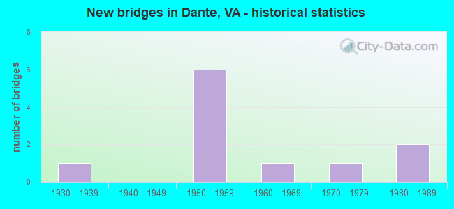
- New bridges - historical statistics
- 11930-1939
- 61950-1959
- 11960-1969
- 11970-1979
- 21980-1989

- Reconstructed bridges - Historical Statistics
- 11950-1959
- 01960-1969
- 01970-1979
- 11980-1989
- 01990-1999
- 22000-2009
- 12010-2019

- Bridge Condition - Deck
- 62.5%Good
- 25.0%Satisfactory
- 12.5%Poor

- Bridge Condition - Superstructure
- 50.0%Good
- 37.5%Satisfactory
- 12.5%Poor

- Bridge Condition - Substructure
- 37.5%Good
- 50.0%Satisfactory
- 12.5%Poor

- Bridge Condition - Channel
- 11.1%Very good
- 11.1%Good
- 33.3%Satisfactory
- 33.3%Fair
- 11.1%Poor
Find on map >> Show street view
Structure Number: 5785, Location: 10.8 TO R83;3.8 TO RUS.CO (Lat: 37.014939, Lng: -82.294431), Route carried "on" structure: State highway 63, Year Built: 1956, Status: Open, Structure Length: 0.88m (2.89ft), Average Daily Traffic: 1,058 (year 2020), Truck Traffic: 10%, Average Future Daily Traffic: 1,164 (year 2040), Design Load: HS 20, Features Intersected: TRAMMEL CREEK @ TRAMMEL, Facility Carried by Structure: DANTE MTN. ROAD
Minimum Vertical Clearance: 30+ m (98+ ft), Kilometerpoint: 21.585, Lanes on structure: 2, Owner: State Highway Agency, Approaching Roadway Width: 9.1m (29.9ft), Skew: 4 degrees, Material/Design: Concrete, Design/Construction: Culvert, Number Of Spans In Main Unit: 2, Length of Maximum Span: 4.3m (14.1ft)
Condition: Channel: Poor, Culverts: Satisfactory, Operating Rating: 44.5 metric tons, Method Used To Determine Operating Rating: Field evaluation and documented engineering judgment, Inventory Rating: 32.7 metric tons, Method Used To Determine Inventory Rating: Field evaluation and documented engineering judgment, Structural Evaluation: Equal to present minimum criteria, Waterway Adequacy: Better than present minimum criteria, Approach Roadway Alignment: Better than present minimum criteria, Designated Inspection Frequency: Every 24 months, Inspection Date: May 2021
Find on map >> Show street view
Structure Number: 5791, Location: 0.04 FR. 656; 1.01 TO 626 (Lat: 37.028219, Lng: -82.299878), Route carried "on" structure: State highway 63, Year Built: 1953, Year Reconstructed: 2012, Status: Open, Structure Length: 2.62m (8.60ft), Average Daily Traffic: 1,058 (year 2020), Truck Traffic: 10%, Average Future Daily Traffic: 1,164 (year 2040), Design Load: HS 20, Features Intersected: ROARING FORK @ TRAMMEL, Facility Carried by Structure: DANTE MOUNTAIN RD.
Minimum Vertical Clearance: 30+ m (98+ ft), Kilometerpoint: 23.160, Lanes on structure: 2, Owner: State Highway Agency, Approaching Roadway Width: 7.9m (25.9ft), Material/Design: Concrete, Design/Construction: Slab, Number Of Spans In Main Unit: 2, Length of Maximum Span: 12.8m (42.0ft), Curb-To-Curb Width: 7.3m (24.0ft), Out-to-Out Width: 9.1m (29.9ft)
Condition: Deck: Good, Superstructure: Good, Substructure: Satisfactory, Channel: Fair, Operating Rating: 59.0 metric tons, Method Used To Determine Operating Rating: Load and Resistance Factor (LRFR), Inventory Rating: 45.4 metric tons, Method Used To Determine Inventory Rating: Load and Resistance Factor (LRFR), Structural Evaluation: Equal to present minimum criteria, Deck Geometry: Meets minimum limits, Waterway Adequacy: Better than present minimum criteria, Approach Roadway Alignment: Better than present minimum criteria, Length Of Structure Improvement: 2.59m (8.50ft), Designated Inspection Frequency: Every 24 months, Inspection Date: June 2020, Bridge Improvement Cost: $190,000, Roadway Improvement Cost: $21,000, Total Project Cost: $274,000, Deck Structure Type: Concrete Cast-file-Place
Find on map >> Show street view
Structure Number: 5872, Location: 2.54 FR 627 -.05 TO 63 (Lat: 37.041586, Lng: -82.316156), Route carried "on" structure: County highway 655, Year Built: 1951, Year Reconstructed: 2008, Status: Open, Structure Length: 1.92m (6.30ft), Average Daily Traffic: 49 (year 2016), Average Future Daily Traffic: 55 (year 2040), Design Load: HS 20+Mod, Features Intersected: MCCLURE RIVER, Facility Carried by Structure: RICHARD LONG ROAD
Minimum Vertical Clearance: 30+ m (98+ ft), Kilometerpoint: 4.246, Lanes on structure: 2, Owner: State Highway Agency, Approaching Roadway Width: 4.6m (15.1ft), Material/Design: Steel, Design/Construction: Stringer/Multi-beam, Number Of Spans In Main Unit: 2, Length of Maximum Span: 11.0m (36.1ft), Curb-To-Curb Width: 5.8m (19.0ft), Out-to-Out Width: 6.1m (20.0ft)
Condition: Deck: Good, Superstructure: Good, Substructure: Satisfactory, Channel: Satisfactory, Operating Rating: 52.6 metric tons, Method Used To Determine Operating Rating: Load Factor (LF), Inventory Rating: 31.8 metric tons, Method Used To Determine Inventory Rating: Load Factor (LF), Structural Evaluation: Equal to present minimum criteria, Deck Geometry: Meets minimum limits, Waterway Adequacy: Better than present minimum criteria, Approach Roadway Alignment: Better than present minimum criteria, Length Of Structure Improvement: 1.92m (6.30ft), Designated Inspection Frequency: Every 24 months, Inspection Date: June 2020, Deck Structure Type: Wood or Timber, Wearing Surface/Protective System: Wearing Surface: Bituminous
Find on map >> Show street view
Structure Number: 5894, Location: 0.01 FR 63 & .79 TO 757 (Lat: 37.034342, Lng: -82.311264), Route carried "on" structure: County highway 715, Year Built: 1980, Status: Open, Structure Length: 1.07m (3.51ft), Average Daily Traffic: 138 (year 2016), Average Future Daily Traffic: 155 (year 2040), Design Load: HS 20+Mod, Features Intersected: MCCLURE RIVER, Facility Carried by Structure: WAKENVA HOLLOW RD
Minimum Vertical Clearance: 30+ m (98+ ft), Kilometerpoint: 1.261, Lanes on structure: 2, Owner: State Highway Agency, Approaching Roadway Width: 5.5m (18.0ft), Material/Design: Concrete, Design/Construction: Slab, Number Of Spans In Main Unit: 1, Length of Maximum Span: 10.0m (32.8ft), Curb or Sidewalk Widths: Left: 0.2m (0.7ft), Right: 0.2m (0.7ft), Curb-To-Curb Width: 7.5m (24.6ft), Out-to-Out Width: 8.4m (27.6ft)
Condition: Deck: Satisfactory, Superstructure: Satisfactory, Substructure: Satisfactory, Channel: Fair, Operating Rating: 89.8 metric tons, Method Used To Determine Operating Rating: Load and Resistance Factor (LRFR), Inventory Rating: 74.4 metric tons, Method Used To Determine Inventory Rating: Load and Resistance Factor (LRFR), Structural Evaluation: Equal to present minimum criteria, Deck Geometry: Somewhat better than minimum adequacy, Waterway Adequacy: Better than present minimum criteria, Approach Roadway Alignment: Better than present minimum criteria, Designated Inspection Frequency: Every 24 months, Inspection Date: December 2021, Deck Structure Type: Concrete Cast-file-Place
Find on map >> Show street view
Structure Number: 16377, Location: 0.35MTO 627 & 0.20MTO 63 (Lat: 36.974778, Lng: -82.298228), Route carried "on" structure: County highway 608, Year Built: 1982, Status: Open, Structure Length: 1.37m (4.49ft), Average Daily Traffic: 629 (year 2015), Average Future Daily Traffic: 708 (year 2040), Design Load: HS 20+Mod, Features Intersected: LICK CREEK, Facility Carried by Structure: BUNCH TOWN ROAD
Minimum Vertical Clearance: 30+ m (98+ ft), Kilometerpoint: 0.322, Lanes on structure: 2, Owner: State Highway Agency, Approaching Roadway Width: 6.7m (22.0ft), Skew: 3 degrees, Material/Design: Prestressed concrete, Design/Construction: Box Beam or Girders - Multiple, Number Of Spans In Main Unit: 1, Length of Maximum Span: 13.1m (43.0ft), Curb-To-Curb Width: 7.6m (24.9ft), Out-to-Out Width: 8.4m (27.6ft)
Condition: Deck: Good, Superstructure: Good, Substructure: Good, Channel: Good, Operating Rating: 89.8 metric tons, Method Used To Determine Operating Rating: Load and Resistance Factor (LRFR), Inventory Rating: 88.9 metric tons, Method Used To Determine Inventory Rating: Load and Resistance Factor (LRFR), Structural Evaluation: Better than present minimum criteria, Deck Geometry: Meets minimum limits, Waterway Adequacy: Better than present minimum criteria, Approach Roadway Alignment: Better than present minimum criteria, Designated Inspection Frequency: Every 24 months, Inspection Date: March 2021, Deck Structure Type: Other, Wearing Surface/Protective System: Wearing Surface: Bituminous
Find on map >> Show street view
Structure Number: 16378, Location: 0.00MTO 627 & .55MTO 63 (Lat: 36.978247, Lng: -82.297728), Route carried "on" structure: County highway 608, Year Built: 1930, Year Reconstructed: 1988, Status: Open, Structure Length: 0.98m (3.22ft), Average Daily Traffic: 629 (year 2015), Average Future Daily Traffic: 708 (year 2040), Design Load: HS 20+Mod, Features Intersected: LICK CREEK, Facility Carried by Structure: BUNCH TOWN ROAD
Minimum Vertical Clearance: 30+ m (98+ ft), Kilometerpoint: 0.016, Lanes on structure: 2, Owner: State Highway Agency, Approaching Roadway Width: 7.3m (24.0ft), Skew: 1 degrees, Material/Design: Concrete, Design/Construction: Slab, Number Of Spans In Main Unit: 1, Length of Maximum Span: 8.8m (28.9ft), Curb or Sidewalk Widths: Left: 2.4m (7.9ft), Right: 2.4m (7.9ft), Curb-To-Curb Width: 7.3m (24.0ft), Out-to-Out Width: 8.6m (28.2ft)
Condition: Deck: Good, Superstructure: Good, Substructure: Good, Channel: Satisfactory, Operating Rating: 89.8 metric tons, Method Used To Determine Operating Rating: Load and Resistance Factor (LRFR), Inventory Rating: 88.9 metric tons, Method Used To Determine Inventory Rating: Load and Resistance Factor (LRFR), Structural Evaluation: Better than present minimum criteria, Deck Geometry: Meets minimum limits, Waterway Adequacy: Better than present minimum criteria, Approach Roadway Alignment: Better than present minimum criteria, Designated Inspection Frequency: Every 24 months, Inspection Date: March 2021, Deck Structure Type: Concrete Cast-file-Place
Find on map >> Show street view
Structure Number: 16404, Location: .01M TO 616& 1.09M TO 616 (Lat: 36.951600, Lng: -82.212500), Route carried "on" structure: County highway 615, Year Built: 1958, Status: Open, Structure Length: 0.98m (3.22ft), Average Daily Traffic: 638 (year 2020), Truck Traffic: 16%, Average Future Daily Traffic: 702 (year 2040), Design Load: HS 20, Features Intersected: CHANEY CREEK, Facility Carried by Structure: GRAVEL LICK ROAD
Minimum Vertical Clearance: 30+ m (98+ ft), Kilometerpoint: 16.290, Lanes on structure: 2, Owner: State Highway Agency, Approaching Roadway Width: 6.1m (20.0ft), Material/Design: Concrete, Design/Construction: Culvert, Number Of Spans In Main Unit: 3, Length of Maximum Span: 3.0m (9.8ft)
Condition: Channel: Fair, Culverts: Satisfactory, Operating Rating: 44.5 metric tons, Method Used To Determine Operating Rating: Field evaluation and documented engineering judgment, Inventory Rating: 32.7 metric tons, Method Used To Determine Inventory Rating: Field evaluation and documented engineering judgment, Structural Evaluation: Equal to present minimum criteria, Waterway Adequacy: Better than present minimum criteria, Approach Roadway Alignment: Better than present minimum criteria, Designated Inspection Frequency: Every 24 months, Inspection Date: September 2021
Find on map >> Show street view
Structure Number: 16427, Location: 0.0M TO 608& 0.95MTO DCL (Lat: 36.979631, Lng: -82.297844), Route carried "on" structure: County highway 627, Year Built: 1968, Status: Open, Structure Length: 0.70m (2.30ft), Average Daily Traffic: 340 (year 2015), Average Future Daily Traffic: 382 (year 2040), Design Load: HS 20+Mod, Features Intersected: LICK CREEK, Facility Carried by Structure: SAWMILL HOLLOW RD
Minimum Vertical Clearance: 30+ m (98+ ft), Kilometerpoint: 1.496, Lanes on structure: 2, Owner: State Highway Agency, Approaching Roadway Width: 7.0m (23.0ft), Skew: 1 degrees, Material/Design: Concrete, Design/Construction: Slab, Number Of Spans In Main Unit: 1, Length of Maximum Span: 6.4m (21.0ft), Curb-To-Curb Width: 7.3m (24.0ft), Out-to-Out Width: 7.9m (25.9ft)
Condition: Deck: Satisfactory, Superstructure: Satisfactory, Substructure: Good, Channel: Satisfactory, Operating Rating: 89.8 metric tons, Method Used To Determine Operating Rating: Load and Resistance Factor (LRFR), Inventory Rating: 78.9 metric tons, Method Used To Determine Inventory Rating: Load and Resistance Factor (LRFR), Structural Evaluation: Equal to present minimum criteria, Deck Geometry: Somewhat better than minimum adequacy, Waterway Adequacy: Better than present minimum criteria, Approach Roadway Alignment: Better than present minimum criteria, Length Of Structure Improvement: 0.70m (2.30ft), Designated Inspection Frequency: Every 24 months, Inspection Date: July 2021, Bridge Improvement Cost: $49,000, Roadway Improvement Cost: $10,000, Total Project Cost: $69,000 ( Estimate for 2016), Deck Structure Type: Concrete Cast-file-Place
Find on map >> Show street view
Structure Number: 16511, Location: .30M TO 627&.25M TO 763 (Lat: 36.976003, Lng: -82.297017), Route carried "on" structure: County highway 687, Year Built: 1957, Year Reconstructed: 1959, Status: Posted for load, Structure Length: 5.20m (17.06ft), Average Daily Traffic: 89 (year 2015), Average Future Daily Traffic: 100 (year 2040), Design Load: H 15, Features Intersected: SR-63, Facility Carried by Structure: ROANOKE HILL ROAD
Minimum Vertical Clearance: 30+ m (98+ ft), Kilometerpoint: 0.640, Lanes on structure: 1, Lanes under structure: 2, Owner: State Highway Agency, Approaching Roadway Width: 5.5m (18.0ft), Skew: 4 degrees, Material/Design: Steel, Design/Construction: Stringer/Multi-beam, Number Of Spans In Main Unit: 3, Length of Maximum Span: 18.6m (61.0ft), Curb or Sidewalk Widths: Left: 0.3m (1.0ft), Right: 0.3m (1.0ft), Curb-To-Curb Width: 4.3m (14.1ft), Out-to-Out Width: 4.9m (16.1ft)
Condition: Deck: Poor, Superstructure: Poor, Substructure: Poor, Operating Rating: 35.4 metric tons, Method Used To Determine Operating Rating: Load Factor (LF), Inventory Rating: 20.9 metric tons, Method Used To Determine Inventory Rating: Load Factor (LF), Structural Evaluation: Meets minimum limits, Deck Geometry: Equal to present minimum criteria, Underclear: High priority of replacement, Approach Roadway Alignment: Equal to present minimum criteria, Length Of Structure Improvement: 5.18m (16.99ft), Designated Inspection Frequency: Every 12 months, Inspection Date: May 2021, Bridge Improvement Cost: $357,000, Roadway Improvement Cost: $50,000, Total Project Cost: $529,000 ( Estimate for 2019), Deck Structure Type: Concrete Cast-file-Place
Find on map >> Show street view
Structure Number: 16534, Location: .00MTO63&.02MTOENDMAINT. (Lat: 36.937686, Lng: -82.284072), Route carried "on" structure: County highway 838, Year Built: 1975, Year Reconstructed: 2016, Status: Posted for load, Structure Length: 1.74m (5.71ft), Average Daily Traffic: 10 (year 2015), Average Future Daily Traffic: 11 (year 2040), Design Load: HS 20, Features Intersected: HAMLIN BRANCH, Facility Carried by Structure: SUN DRIVE
Minimum Vertical Clearance: 30+ m (98+ ft), Kilometerpoint: 0.000, Lanes on structure: 1, Owner: State Highway Agency, Approaching Roadway Width: 4.9m (16.1ft), Material/Design: Steel, Design/Construction: Stringer/Multi-beam, Number Of Spans In Main Unit: 3, Length of Maximum Span: 8.5m (27.9ft), Curb or Sidewalk Widths: Left: 0.2m (0.7ft), Right: 0.2m (0.7ft), Curb-To-Curb Width: 3.4m (11.2ft), Out-to-Out Width: 3.7m (12.1ft)
Condition: Deck: Good, Superstructure: Satisfactory, Substructure: Satisfactory, Channel: Very good, Operating Rating: 34.5 metric tons, Method Used To Determine Operating Rating: Load and Resistance Factor (LRFR), Inventory Rating: 26.3 metric tons, Method Used To Determine Inventory Rating: Load and Resistance Factor (LRFR), Structural Evaluation: Equal to present minimum criteria, Deck Geometry: High priority of corrective action, Waterway Adequacy: Better than present minimum criteria, Approach Roadway Alignment: Better than present minimum criteria, Length Of Structure Improvement: 1.74m (5.71ft), Designated Inspection Frequency: Every 24 months, Inspection Date: October 2020, Deck Structure Type: Wood or Timber, Wearing Surface/Protective System: Wearing Surface: Bituminous
Find on map >> Show street view
Structure Number: 16511, Location: .30M TO 627&.25M TO 763 (Lat: 36.976003, Lng: -82.297017), Route carried "under" structure: State highway 63, Year Built: 1957, Structure Length: 0. m, Average Daily Traffic: 1,300 (year 2017), Truck Traffic: 7%, Features Intersected: SR-63, Facility Carried by Structure: ROANOKE HILL ROAD
Minimum Vertical Clearance: 10.26m (33.66ft), Kilometerpoint: 12.084, Lanes on structure: 1, Lanes under structure: 2, Material/Design: Steel, Design/Construction: Stringer/Multi-beam, Length of Maximum Span: 18.6m (61.0ft)