Bridge Statistics for Dardenne Prairie, Missouri (MO)
Condition, Traffic, Stress, Structural Evaluation, Project Costs
- National Bridge Inventory (NBI) Statistics
- 12Number of bridges
- 75ft / 23.3mTotal length
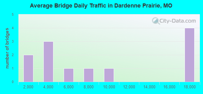
- 96,116Total average daily traffic
- 4,828Total average daily truck traffic
- National Bridge Inventory (NBI) Registered Bridges for Dardenne Prairie
- No street view available for this location
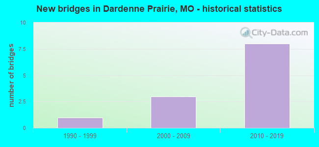
- New bridges - historical statistics
- 11990-1999
- 32000-2009
- 82010-2019
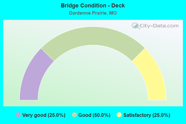
- Bridge Condition - Deck
- 25.0%Very good
- 50.0%Good
- 25.0%Satisfactory
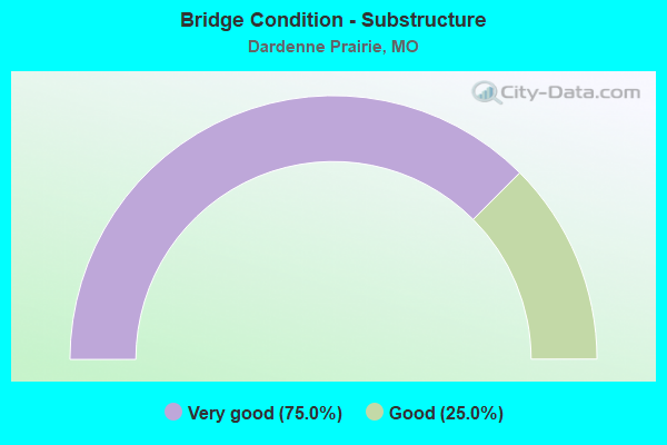
- Bridge Condition - Substructure
- 75.0%Very good
- 25.0%Good
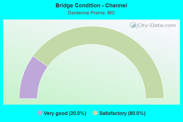
- Bridge Condition - Channel
- 20.0%Very good
- 80.0%Satisfactory
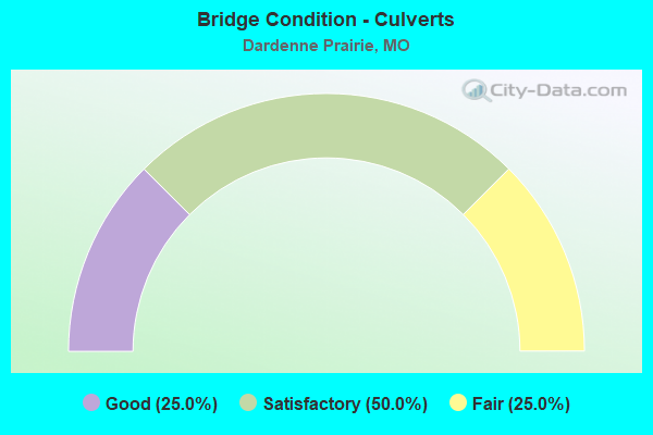
- Bridge Condition - Culverts
- 25.0%Good
- 50.0%Satisfactory
- 25.0%Fair
Find on map >> Show street view
Structure Number: 28193, Location: S 11 T 46 N R 2 E (Lat: 38.762081, Lng: -90.759822), Route carried "on" structure: County highway 475, Year Built: 1998, Status: Open, Structure Length: 0.70m (2.30ft), Average Daily Traffic: 314 (year 2020), Truck Traffic: 1%, Average Future Daily Traffic: 487 (year 2040), Design Load: HS 20, Features Intersected: TRIB 15, Facility Carried by Structure: OLD DOMINION ST
Minimum Vertical Clearance: 30+ m (98+ ft), Kilometerpoint: 0.117, Lanes on structure: 2, Owner: County Highway Agency, Approaching Roadway Width: 7.9m (25.9ft), Material/Design: Concrete, Design/Construction: Culvert, Number Of Spans In Main Unit: 2, Length of Maximum Span: 3.0m (9.8ft)
Condition: Channel: Satisfactory, Culverts: Fair, Operating Rating: 54.0 metric tons, Method Used To Determine Operating Rating: Field evaluation and documented engineering judgment, Inventory Rating: 32.4 metric tons, Method Used To Determine Inventory Rating: Field evaluation and documented engineering judgment, Structural Evaluation: Somewhat better than minimum adequacy, Waterway Adequacy: Superior to present desirable criteria, Approach Roadway Alignment: Equal to present desirable criteria, Designated Inspection Frequency: Every 24 months, Inspection Date: Febuary 2022
Find on map >> Show street view
Structure Number: 287, Location: S 1669 T 46 N R 3 E (Lat: 38.751525, Lng: -90.715358), Route carried "on" structure: City street 269, Year Built: 2001, Status: Open, Structure Length: 1.19m (3.90ft), Average Daily Traffic: 8,333 (year 2020), Truck Traffic: 5%, Average Future Daily Traffic: 12,916 (year 2040), Design Load: HS 20, Features Intersected: TRIB OF DARDENNE C, Facility Carried by Structure: MCCLURE RD
Minimum Vertical Clearance: 30+ m (98+ ft), Kilometerpoint: 0.805, Lanes on structure: 2, Owner: City or Municipal Highway Agency, Maintenance Responsibility: County Highway Agency, Approaching Roadway Width: 11.9m (39.0ft), Skew: 1 degrees, Material/Design: Concrete continuous, Design/Construction: Culvert, Number Of Spans In Main Unit: 3, Length of Maximum Span: 3.7m (12.1ft), Curb-To-Curb Width: 12.0m (39.4ft), Out-to-Out Width: 12.0m (39.4ft)
Condition: Channel: Satisfactory, Culverts: Satisfactory, Operating Rating: 59.4 metric tons, Method Used To Determine Operating Rating: Load Factor (LF), Inventory Rating: 35.1 metric tons, Method Used To Determine Inventory Rating: Load Factor (LF), Structural Evaluation: Equal to present minimum criteria, Deck Geometry: Somewhat better than minimum adequacy, Waterway Adequacy: Superior to present desirable criteria, Approach Roadway Alignment: Equal to present desirable criteria, Designated Inspection Frequency: Every 24 months, Inspection Date: January 2022
Find on map >> Show street view
Structure Number: 32117, Location: S 1669 T 46 N R 3 E (Lat: 38.763319, Lng: -90.735700), Route carried "on" structure: City street , Year Built: 2009, Status: Open, Structure Length: 0.82m (2.69ft), Average Daily Traffic: 2,525 (year 2020), Truck Traffic: 2%, Average Future Daily Traffic: 3,914 (year 2040), Design Load: HS 20, Features Intersected: DARDENNE CR, Facility Carried by Structure: BATES RD
Minimum Vertical Clearance: 30+ m (98+ ft), Kilometerpoint: 0.161, Lanes on structure: 3, Owner: City or Municipal Highway Agency, Maintenance Responsibility: County Highway Agency, Approaching Roadway Width: 11.9m (39.0ft), Material/Design: Concrete continuous, Design/Construction: Culvert, Number Of Spans In Main Unit: 3, Length of Maximum Span: 2.6m (8.5ft), Curb or Sidewalk Widths: Left: 0.0m, Right: 1.2m (3.9ft)
Condition: Channel: Satisfactory, Culverts: Satisfactory, Operating Rating: 54.0 metric tons, Method Used To Determine Operating Rating: Load Factor (LF), Inventory Rating: 32.4 metric tons, Method Used To Determine Inventory Rating: Load Factor (LF), Structural Evaluation: Equal to present minimum criteria, Waterway Adequacy: Superior to present desirable criteria, Approach Roadway Alignment: Equal to present desirable criteria, Designated Inspection Frequency: Every 24 months, Inspection Date: January 2022
Find on map >> Show street view
Structure Number: 32961, Location: S 1669 T 46 N R 3 E (Lat: 38.732103, Lng: -90.727936), Route carried "on" structure: City street , Year Built: 2008, Status: Open, Structure Length: 1.13m (3.71ft), Average Daily Traffic: 599 (year 2020), Truck Traffic: 10%, Average Future Daily Traffic: 928 (year 2040), Design Load: HS 20, Features Intersected: TRIB OF DARDENNE C, Facility Carried by Structure: BARATHAVEN BLVD
Minimum Vertical Clearance: 30+ m (98+ ft), Kilometerpoint: 0.000, Lanes on structure: 2, Owner: City or Municipal Highway Agency, Maintenance Responsibility: County Highway Agency, Approaching Roadway Width: 9.8m (32.2ft), Material/Design: Concrete, Design/Construction: Culvert, Number Of Spans In Main Unit: 1, Length of Maximum Span: 11.3m (37.1ft), Curb or Sidewalk Widths: Left: 1.5m (4.9ft), Right: 2.4m (7.9ft), Curb-To-Curb Width: 9.8m (32.2ft), Out-to-Out Width: 14.3m (46.9ft)
Condition: Channel: Very good, Culverts: Good, Operating Rating: 54.0 metric tons, Method Used To Determine Operating Rating: Load Factor (LF), Inventory Rating: 32.4 metric tons, Method Used To Determine Inventory Rating: Load Factor (LF), Structural Evaluation: Better than present minimum criteria, Deck Geometry: Equal to present minimum criteria, Waterway Adequacy: Superior to present desirable criteria, Approach Roadway Alignment: Equal to present desirable criteria, Designated Inspection Frequency: Every 24 months, Inspection Date: January 2022
Find on map >> Show street view
Structure Number: 33197, Location: S 1641 T 45 N R 3 E (Lat: 38.736628, Lng: -90.721958), Route carried "on" structure: City street , Year Built: 2011, Status: Open, Structure Length: 9.33m (30.61ft), Average Daily Traffic: 4,122 (year 2020), Truck Traffic: 2%, Average Future Daily Traffic: 6,389 (year 2040), Design Load: HS 20+Mod, Features Intersected: DARDENNE CR, Facility Carried by Structure: HENNING RD
Minimum Vertical Clearance: 30+ m (98+ ft), Kilometerpoint: 1.165, Lanes on structure: 2, Owner: City or Municipal Highway Agency, Maintenance Responsibility: County Highway Agency, Approaching Roadway Width: 11.0m (36.1ft), Material/Design: Prestressed concrete continuous, Design/Construction: Stringer/Multi-beam, Number Of Spans In Main Unit: 3, Length of Maximum Span: 30.8m (101.0ft), Curb-To-Curb Width: 8.5m (27.9ft), Out-to-Out Width: 12.2m (40.0ft)
Condition: Deck: Satisfactory, Superstructure: Good, Substructure: Very good, Channel: Satisfactory, Operating Rating: 69.3 metric tons, Method Used To Determine Operating Rating: Load Factor (LF), Inventory Rating: 36.0 metric tons, Method Used To Determine Inventory Rating: Load Factor (LF), Structural Evaluation: Better than present minimum criteria, Deck Geometry: Meets minimum limits, Waterway Adequacy: Superior to present desirable criteria, Approach Roadway Alignment: Equal to present desirable criteria, Designated Inspection Frequency: Every 24 months, Inspection Date: January 2022, Deck Structure Type: Concrete Precast Panels, Wearing Surface/Protective System: Wearing Surface: Monolithic Concrete, Deck Protection: Epoxy Coated Reinforcing
Find on map >> Show street view
Structure Number: 3451, Location: S 1 T 46 N R 2 E (Lat: 38.767911, Lng: -90.742150), Route carried "on" structure: State highway N, Year Built: 2013, Status: Open, Structure Length: 5.52m (18.11ft), Average Daily Traffic: 6,330 (year 2021), Truck Traffic: 3%, Average Future Daily Traffic: 11,394 (year 2041), Features Intersected: MO 364, RP MO364W TO RTN
Minimum Vertical Clearance: 30+ m (98+ ft), Kilometerpoint: 21.002, Lanes on structure: 6, Lanes under structure: 5, Base Highway Network: Yes, Owner: State Highway Agency, Approaching Roadway Width: 22.9m (75.1ft), Skew: 2 degrees, Material/Design: Prestressed concrete continuous, Design/Construction: Stringer/Multi-beam, Number Of Spans In Main Unit: 2, Length of Maximum Span: 29.6m (97.1ft), Curb or Sidewalk Widths: Left: 1.6m (5.2ft), Right: 2.5m (8.2ft), Curb-To-Curb Width: 22.9m (75.1ft), Out-to-Out Width: 28.1m (92.2ft)
Condition: Deck: Good, Superstructure: Good, Substructure: Good, Operating Rating: 84.6 metric tons, Method Used To Determine Operating Rating: Load Factor (LF), Inventory Rating: 38.7 metric tons, Method Used To Determine Inventory Rating: Load Factor (LF), Structural Evaluation: Better than present minimum criteria, Deck Geometry: Meets minimum limits, Underclear: Meets minimum limits, Approach Roadway Alignment: Equal to present desirable criteria, Designated Inspection Frequency: Every 24 months, Inspection Date: September 2021, Deck Structure Type: Concrete Cast-file-Place, Wearing Surface/Protective System: Wearing Surface: Monolithic Concrete, Deck Protection: Epoxy Coated Reinforcing
Find on map >> Show street view
Structure Number: 34516, Location: S 1 T 46 N R 2 E (Lat: 38.766111, Lng: -90.756111), Route carried "on" structure: State highway 364, Year Built: 2013, Status: Open, Structure Length: 2.30m (7.55ft), Average Daily Traffic: 16,862 (year 2021), Truck Traffic: 6%, Average Future Daily Traffic: 28,665 (year 2041), Features Intersected: CST HANLEY RD
Minimum Vertical Clearance: 5.61m (18.41ft), Kilometerpoint: 2.345, Lanes on structure: 2, Lanes under structure: 2, Base Highway Network: Yes, Owner: State Highway Agency, Approaching Roadway Width: 11.6m (38.1ft), Material/Design: Prestressed concrete, Design/Construction: Stringer/Multi-beam, Number Of Spans In Main Unit: 1, Length of Maximum Span: 21.9m (71.9ft), Curb-To-Curb Width: 11.6m (38.1ft), Out-to-Out Width: 12.4m (40.7ft)
Condition: Deck: Very good, Superstructure: Good, Substructure: Very good, Operating Rating: 69.3 metric tons, Method Used To Determine Operating Rating: Load Factor (LF), Inventory Rating: 36.0 metric tons, Method Used To Determine Inventory Rating: Load Factor (LF), Structural Evaluation: Better than present minimum criteria, Deck Geometry: Equal to present minimum criteria, Underclear: Somewhat better than minimum adequacy, Approach Roadway Alignment: Equal to present desirable criteria, Designated Inspection Frequency: Every 24 months, Inspection Date: September 2021, Deck Structure Type: Concrete Cast-file-Place, Wearing Surface/Protective System: Wearing Surface: Monolithic Concrete, Deck Protection: Epoxy Coated Reinforcing
Find on map >> Show street view
Structure Number: 34517, Location: S 1 T 46 N R 2 E (Lat: 38.766111, Lng: -90.756111), Route carried "on" structure: State highway 364, Year Built: 2013, Status: Open, Structure Length: 2.30m (7.55ft), Average Daily Traffic: 17,917 (year 2021), Truck Traffic: 5%, Average Future Daily Traffic: 30,459 (year 2041), Features Intersected: CST HANLEY RD
Minimum Vertical Clearance: 5.16m (16.93ft), Kilometerpoint: 32.036, Lanes on structure: 2, Lanes under structure: 2, Base Highway Network: Yes, Owner: State Highway Agency, Approaching Roadway Width: 11.6m (38.1ft), Material/Design: Prestressed concrete, Design/Construction: Stringer/Multi-beam, Number Of Spans In Main Unit: 1, Length of Maximum Span: 21.9m (71.9ft), Curb-To-Curb Width: 11.6m (38.1ft), Out-to-Out Width: 12.4m (40.7ft)
Condition: Deck: Good, Superstructure: Good, Substructure: Very good, Operating Rating: 69.3 metric tons, Method Used To Determine Operating Rating: Load Factor (LF), Inventory Rating: 36.0 metric tons, Method Used To Determine Inventory Rating: Load Factor (LF), Structural Evaluation: Better than present minimum criteria, Deck Geometry: Equal to present minimum criteria, Underclear: Somewhat better than minimum adequacy, Approach Roadway Alignment: Equal to present desirable criteria, Designated Inspection Frequency: Every 24 months, Inspection Date: September 2021, Deck Structure Type: Concrete Cast-file-Place, Wearing Surface/Protective System: Wearing Surface: Monolithic Concrete, Deck Protection: Epoxy Coated Reinforcing
Find on map >> Show street view
Structure Number: 3451, Location: S 1 T 46 N R 2 E (Lat: 38.767911, Lng: -90.742150), Route carried "under" structure: State highway 364, Year Built: 2013, Structure Length: 0. m, Average Daily Traffic: 16,862 (year 2021), Truck Traffic: 6%, Features Intersected: MO 364, Facility Carried by Structure: RT N E
Minimum Vertical Clearance: 5.61m (18.41ft), Kilometerpoint: 3.584, Lanes on structure: 6, Lanes under structure: 2, Material/Design: Prestressed concrete continuous, Design/Construction: Stringer/Multi-beam, Length of Maximum Span: 29.6m (97.1ft)
Find on map >> Show street view
Structure Number: 3451, Location: S 1 T 46 N R 2 E (Lat: 38.767911, Lng: -90.742150), Route carried "under" structure: State highway 364, Year Built: 2013, Structure Length: 0. m, Average Daily Traffic: 17,924 (year 2021), Truck Traffic: 5%, Features Intersected: MO 364, Facility Carried by Structure: RT N E
Minimum Vertical Clearance: 5.56m (18.24ft), Kilometerpoint: 30.803, Lanes on structure: 6, Lanes under structure: 2, Material/Design: Prestressed concrete continuous, Design/Construction: Stringer/Multi-beam, Length of Maximum Span: 29.6m (97.1ft)
Find on map >> Show street view
Structure Number: 34516, Location: S 1 T 46 N R 2 E (Lat: 38.766111, Lng: -90.756111), Route carried "under" structure: City street , Year Built: 2013, Structure Length: 0. m, Average Daily Traffic: 2,164 (year 2021), Truck Traffic: 5%, Features Intersected: CST HANLEY RD, Facility Carried by Structure: MO 364 E
Minimum Vertical Clearance: 5.61m (18.41ft), Kilometerpoint: 0.000, Lanes on structure: 2, Lanes under structure: 2, Material/Design: Prestressed concrete, Design/Construction: Stringer/Multi-beam, Length of Maximum Span: 21.9m (71.9ft)
Find on map >> Show street view
Structure Number: 34517, Location: S 1 T 46 N R 2 E (Lat: 38.766111, Lng: -90.756111), Route carried "under" structure: City street , Year Built: 2013, Structure Length: 0. m, Average Daily Traffic: 2,164 (year 2021), Truck Traffic: 5%, Features Intersected: CST HANLEY RD, Facility Carried by Structure: MO 364 W
Minimum Vertical Clearance: 5.16m (16.93ft), Kilometerpoint: 0.000, Lanes on structure: 2, Lanes under structure: 2, Material/Design: Prestressed concrete, Design/Construction: Stringer/Multi-beam, Length of Maximum Span: 21.9m (71.9ft)