Bridge Statistics for Darlington, Pennsylvania (PA)
Condition, Traffic, Stress, Structural Evaluation, Project Costs
- National Bridge Inventory (NBI) Statistics
- 11Number of bridges
- 75ft / 23.2mTotal length
- $1,002,000Total costs
- 72,307Total average daily traffic
- 4,971Total average daily truck traffic
- National Bridge Inventory (NBI) Registered Bridges for Darlington
- No street view available for this location
- New bridges - historical statistics
- 81950-1959
- 11980-1989
- 12000-2009
- 12010-2019
- Reconstructed bridges - Historical Statistics
- 21970-1979
- 01980-1989
- 11990-1999
- 02000-2009
- 12010-2019
- Bridge Condition - Deck
- 14.3%Very good
- 28.6%Good
- 28.6%Satisfactory
- 14.3%Fair
- 14.3%Poor
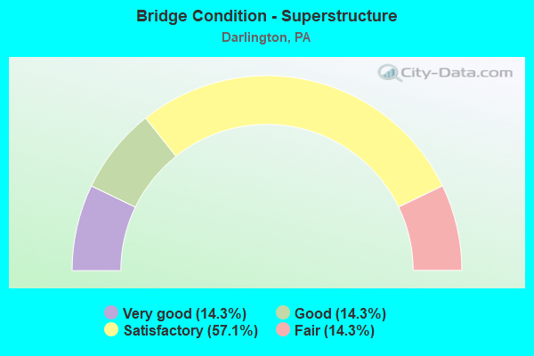
- Bridge Condition - Superstructure
- 14.3%Very good
- 14.3%Good
- 57.1%Satisfactory
- 14.3%Fair
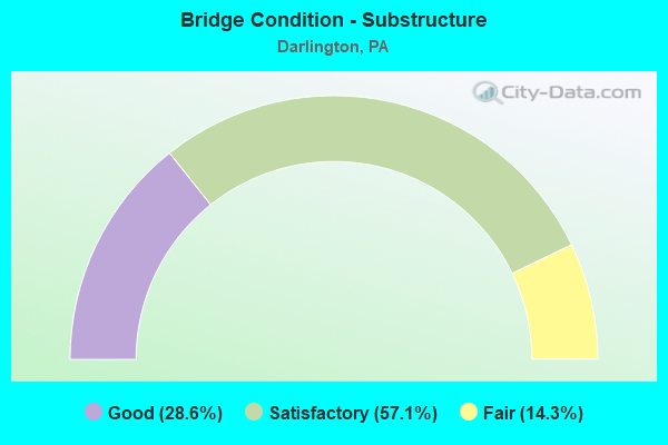
- Bridge Condition - Substructure
- 28.6%Good
- 57.1%Satisfactory
- 14.3%Fair
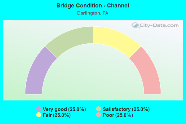
- Bridge Condition - Channel
- 25.0%Very good
- 25.0%Satisfactory
- 25.0%Fair
- 25.0%Poor
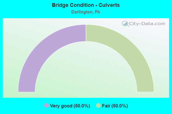
- Bridge Condition - Culverts
- 50.0%Very good
- 50.0%Fair
Find on map >> Show street view
Structure Number: 3496, Location: 400' S.E. OF SR 4013 (Lat: 40.794972, Lng: -80.422078), Route carried "on" structure: State highway 51, Year Built: 1953, Status: Open, Structure Length: 0.88m (2.89ft), Average Daily Traffic: 15,260 (year 2022), Truck Traffic: 6%, Average Future Daily Traffic: 9,727 (year 2032), Design Load: HS 20, Features Intersected: SMALL RUN, Facility Carried by Structure: PENNSYLVANIA AV
Minimum Vertical Clearance: 30+ m (98+ ft), Kilometerpoint: 33.178, Lanes on structure: 4, Base Highway Network: Yes, Owner: State Highway Agency, Approaching Roadway Width: 21.9m (71.9ft), Skew: 24 degrees, Material/Design: Concrete, Design/Construction: Culvert, Number Of Spans In Main Unit: 1, Length of Maximum Span: 8.8m (28.9ft)
Condition: Channel: Satisfactory, Culverts: Fair, Inventory Rating: 99.8 metric tons, Method Used To Determine Inventory Rating: Field evaluation and documented engineering judgment, Structural Evaluation: Somewhat better than minimum adequacy, Waterway Adequacy: Superior to present desirable criteria, Approach Roadway Alignment: Equal to present desirable criteria, Length Of Structure Improvement: 0.90m (2.95ft), Designated Inspection Frequency: Every 24 months, Inspection Date: August 2021, Bridge Improvement Cost: $16,000, Roadway Improvement Cost: $46,000, Total Project Cost: $211,000
Find on map >> Show street view
Structure Number: 3498, Location: 1/2 MI. NW OF SR 168 (Lat: 40.802528, Lng: -80.440689), Route carried "on" structure: State highway 51, Year Built: 1953, Year Reconstructed: 1977, Status: Open, Structure Length: 10.06m (33.01ft), Average Daily Traffic: 11,435 (year 2022), Truck Traffic: 8%, Average Future Daily Traffic: 10,365 (year 2032), Design Load: HS 20, Features Intersected: LITTLE BEAVER CREEK, Facility Carried by Structure: PENNSYLVANIA AV
Minimum Vertical Clearance: 30+ m (98+ ft), Kilometerpoint: 34.688, Lanes on structure: 4, Base Highway Network: Yes, Owner: State Highway Agency, Approaching Roadway Width: 26.2m (86.0ft), Skew: 23 degrees, Material/Design: Steel continuous, Design/Construction: Stringer/Multi-beam, Number Of Spans In Main Unit: 4, Length of Maximum Span: 22.9m (75.1ft), Curb or Sidewalk Widths: Left: 0.2m (0.7ft), Right: 0.2m (0.7ft), Curb-To-Curb Width: 26.2m (86.0ft), Out-to-Out Width: 27.4m (89.9ft)
Condition: Deck: Good, Superstructure: Satisfactory, Substructure: Satisfactory, Channel: Poor, Operating Rating: 59.9 metric tons, Method Used To Determine Operating Rating: Load Factor (LF), Inventory Rating: 35.4 metric tons, Method Used To Determine Inventory Rating: Load Factor (LF), Structural Evaluation: Equal to present minimum criteria, Deck Geometry: Superior to present desirable criteria, Waterway Adequacy: Superior to present desirable criteria, Approach Roadway Alignment: Equal to present desirable criteria, Length Of Structure Improvement: 11.00m (36.09ft), Designated Inspection Frequency: Every 24 months, Inspection Date: August 2021, Deck Structure Type: Concrete Cast-file-Place, Wearing Surface/Protective System: Wearing Surface: Latex Concrete, Deck Protection: Epoxy Coated Reinforcing
Find on map >> Show street view
Structure Number: 3499, Location: 150'S.E.Y&S R.R.AT CRSIG. (Lat: 40.803806, Lng: -80.443658), Route carried "on" structure: State highway 51, Year Built: 1952, Year Reconstructed: 1978, Status: Open, Structure Length: 0.70m (2.30ft), Average Daily Traffic: 11,435 (year 2022), Truck Traffic: 8%, Average Future Daily Traffic: 10,365 (year 2032), Design Load: HS 20, Features Intersected: Trib N Fork Little Bvr C, Facility Carried by Structure: CONSTITUTION BL
Minimum Vertical Clearance: 30+ m (98+ ft), Kilometerpoint: 34.688, Lanes on structure: 4, Base Highway Network: Yes, Owner: State Highway Agency, Approaching Roadway Width: 25.6m (84.0ft), Skew: 20 degrees, Material/Design: Concrete, Design/Construction: Slab, Number Of Spans In Main Unit: 1, Length of Maximum Span: 6.1m (20.0ft), Curb-To-Curb Width: 25.6m (84.0ft), Out-to-Out Width: 27.4m (89.9ft)
Condition: Deck: Good, Superstructure: Good, Substructure: Satisfactory, Channel: Fair, Operating Rating: 53.5 metric tons, Method Used To Determine Operating Rating: Load Factor (LF), Inventory Rating: 31.8 metric tons, Method Used To Determine Inventory Rating: Load Factor (LF), Structural Evaluation: Equal to present minimum criteria, Deck Geometry: Superior to present desirable criteria, Waterway Adequacy: Equal to present minimum criteria, Approach Roadway Alignment: Equal to present desirable criteria, Length Of Structure Improvement: 0.70m (2.30ft), Designated Inspection Frequency: Every 24 months, Inspection Date: August 2021, Bridge Improvement Cost: $24,000, Roadway Improvement Cost: $70,000, Total Project Cost: $321,000, Deck Structure Type: Concrete Cast-file-Place, Wearing Surface/Protective System: Wearing Surface: Latex Concrete
Find on map >> Show street view
Structure Number: 3501, Location: 1/4 MI.N.W.OF TWP.RD.625 (Lat: 40.815750, Lng: -80.461242), Route carried "on" structure: State highway 51, Year Built: 1953, Year Reconstructed: 1990, Status: Open, Structure Length: 0.85m (2.79ft), Average Daily Traffic: 11,119 (year 2022), Truck Traffic: 9%, Average Future Daily Traffic: 11,051 (year 2032), Design Load: HS 20, Features Intersected: DILWORTH RUN, Facility Carried by Structure: CONSTITUTION BL
Minimum Vertical Clearance: 30+ m (98+ ft), Kilometerpoint: 37.063, Lanes on structure: 4, Base Highway Network: Yes, Owner: State Highway Agency, Approaching Roadway Width: 25.6m (84.0ft), Skew: 24 degrees, Material/Design: Concrete, Design/Construction: Slab, Number Of Spans In Main Unit: 1, Length of Maximum Span: 7.9m (25.9ft), Curb-To-Curb Width: 26.2m (86.0ft), Out-to-Out Width: 27.4m (89.9ft)
Condition: Deck: Satisfactory, Superstructure: Satisfactory, Substructure: Satisfactory, Channel: Poor, Operating Rating: 95.3 metric tons, Method Used To Determine Operating Rating: Load Factor (LF), Inventory Rating: 57.2 metric tons, Method Used To Determine Inventory Rating: Load Factor (LF), Structural Evaluation: Equal to present minimum criteria, Deck Geometry: Superior to present desirable criteria, Waterway Adequacy: Equal to present minimum criteria, Approach Roadway Alignment: Equal to present desirable criteria, Length Of Structure Improvement: 0.90m (2.95ft), Designated Inspection Frequency: Every 24 months, Inspection Date: August 2021, Bridge Improvement Cost: $8,000, Roadway Improvement Cost: $25,000, Total Project Cost: $110,000, Deck Structure Type: Concrete Cast-file-Place, Wearing Surface/Protective System: Wearing Surface: Epoxy Overlay
Find on map >> Show street view
Structure Number: 3603, Location: 1000' NORTH OF SR 4013 (Lat: 40.806317, Lng: -80.422936), Route carried "on" structure: Spur State highway 168, Year Built: 1985, Status: Open, Structure Length: 3.05m (10.01ft), Average Daily Traffic: 4,795 (year 2022), Truck Traffic: 2%, Average Future Daily Traffic: 6,694 (year 2032), Design Load: HS 20, Features Intersected: N.FORK LITTLE BEAVER CK., Facility Carried by Structure: TUSCARAWAS RD
Minimum Vertical Clearance: 30+ m (98+ ft), Kilometerpoint: 44.741, Lanes on structure: 2, Owner: State Highway Agency, Approaching Roadway Width: 9.4m (30.8ft), Material/Design: Prestressed concrete, Design/Construction: Box Beam or Girders - Multiple, Number Of Spans In Main Unit: 1, Length of Maximum Span: 29.6m (97.1ft), Curb or Sidewalk Widths: Left: 0.2m (0.7ft), Right: 0.2m (0.7ft), Curb-To-Curb Width: 10.1m (33.1ft), Out-to-Out Width: 11.3m (37.1ft)
Condition: Deck: Satisfactory, Superstructure: Satisfactory, Substructure: Satisfactory, Channel: Satisfactory, Inventory Rating: 70.8 metric tons, Method Used To Determine Inventory Rating: Load Factor (LF), Structural Evaluation: Equal to present minimum criteria, Deck Geometry: Meets minimum limits, Waterway Adequacy: Equal to present minimum criteria, Approach Roadway Alignment: Equal to present desirable criteria, Length Of Structure Improvement: 3.00m (9.84ft), Designated Inspection Frequency: Every 24 months, Inspection Date: March 2021, Deck Structure Type: Concrete Cast-file-Place, Wearing Surface/Protective System: Wearing Surface: Monolithic Concrete, Deck Protection: Epoxy Coated Reinforcing
Find on map >> Show street view
Structure Number: 3736, Location: 500' SW OF SR 0051 (Lat: 40.804078, Lng: -80.447239), Route carried "on" structure: State highway , Year Built: 1955, Year Reconstructed: 2010, Status: Open, Structure Length: 1.10m (3.61ft), Average Daily Traffic: 1,704 (year 2022), Truck Traffic: 8%, Average Future Daily Traffic: 2,037 (year 2032), Design Load: HS 20, Features Intersected: DILWORTH RUN, Facility Carried by Structure: CANNELTON ROAD
Minimum Vertical Clearance: 30+ m (98+ ft), Kilometerpoint: 7.046, Lanes on structure: 2, Owner: State Highway Agency, Approaching Roadway Width: 6.7m (22.0ft), Material/Design: Concrete, Design/Construction: Slab, Number Of Spans In Main Unit: 1, Length of Maximum Span: 9.1m (29.9ft), Curb-To-Curb Width: 7.7m (25.3ft), Out-to-Out Width: 8.8m (28.9ft)
Condition: Deck: Very good, Superstructure: Very good, Substructure: Good, Channel: Very good, Operating Rating: 73.5 metric tons, Method Used To Determine Operating Rating: Load Factor (LF), Inventory Rating: 43.5 metric tons, Method Used To Determine Inventory Rating: Load Factor (LF), Structural Evaluation: Better than present minimum criteria, Deck Geometry: Meets minimum limits, Waterway Adequacy: Equal to present desirable criteria, Approach Roadway Alignment: Equal to present desirable criteria, Length Of Structure Improvement: 1.10m (3.61ft), Designated Inspection Frequency: Every 24 months, Inspection Date: Febuary 2021, Bridge Improvement Cost: $11,000, Roadway Improvement Cost: $31,000, Total Project Cost: $144,000, Deck Structure Type: Concrete Cast-file-Place, Wearing Surface/Protective System: Wearing Surface: Monolithic Concrete, Deck Protection: Galvanized Reinforcing
Find on map >> Show street view
Structure Number: 3791, Location: 1025'N.W. OF SR 4013 (Lat: 40.796697, Lng: -80.426853), Route carried "on" structure: State highway , Year Built: 1952, Status: Open, Structure Length: 4.94m (16.21ft), Average Daily Traffic: 363 (year 2020), Truck Traffic: 2%, Average Future Daily Traffic: 459 (year 2032), Design Load: HS 20, Features Intersected: SR 0051, Facility Carried by Structure: GEORGETOWN RD.
Minimum Vertical Clearance: 30+ m (98+ ft), Kilometerpoint: 0.000, Lanes on structure: 2, Lanes under structure: 8, Owner: State Highway Agency, Approaching Roadway Width: 7.6m (24.9ft), Skew: 1 degrees, Material/Design: Steel, Design/Construction: Stringer/Multi-beam, Number Of Spans In Main Unit: 3, Length of Maximum Span: 27.4m (89.9ft), Curb or Sidewalk Widths: Left: 0.3m (1.0ft), Right: 0.3m (1.0ft), Curb-To-Curb Width: 8.5m (27.9ft), Out-to-Out Width: 9.8m (32.2ft)
Condition: Deck: Poor, Superstructure: Satisfactory, Substructure: Fair, Operating Rating: 52.6 metric tons, Method Used To Determine Operating Rating: Load Factor (LF), Inventory Rating: 31.8 metric tons, Method Used To Determine Inventory Rating: Load Factor (LF), Structural Evaluation: Somewhat better than minimum adequacy, Deck Geometry: Equal to present minimum criteria, Underclear: Meets minimum limits, Approach Roadway Alignment: Equal to present desirable criteria, Length Of Structure Improvement: 4.90m (16.08ft), Designated Inspection Frequency: Every 24 months, Inspection Date: September 2021, Bridge Improvement Cost: $16,000, Roadway Improvement Cost: $47,000, Total Project Cost: $216,000, Deck Structure Type: Concrete Cast-file-Place, Wearing Surface/Protective System: Wearing Surface: Monolithic Concrete
Find on map >> Show street view
Structure Number: 4262, Location: 004056 .25 MI N. T-601 (Lat: 40.787847, Lng: -80.461264), Route carried "on" structure: City street , Year Built: 2002, Status: Open, Structure Length: 0.82m (2.69ft), Average Daily Traffic: 85 (year 2021), Truck Traffic: 1%, Average Future Daily Traffic: 150 (year 2043), Design Load: HS 20, Features Intersected: PAINTERS RUN, Facility Carried by Structure: HODGSON RD (T-599)
Minimum Vertical Clearance: 30+ m (98+ ft), Kilometerpoint: 0.000, Lanes on structure: 2, Owner: County Highway Agency, Approaching Roadway Width: 6.1m (20.0ft), Skew: 2 degrees, Material/Design: Prestressed concrete, Design/Construction: Slab, Number Of Spans In Main Unit: 1, Length of Maximum Span: 7.3m (24.0ft), Curb or Sidewalk Widths: Left: 0.2m (0.7ft), Right: 0.2m (0.7ft), Curb-To-Curb Width: 7.7m (25.3ft), Out-to-Out Width: 8.6m (28.2ft)
Condition: Deck: Fair, Superstructure: Fair, Substructure: Good, Channel: Fair, Operating Rating: 68.9 metric tons, Method Used To Determine Operating Rating: Load Factor (LF), Inventory Rating: 44.5 metric tons, Method Used To Determine Inventory Rating: Load Factor (LF), Structural Evaluation: Somewhat better than minimum adequacy, Deck Geometry: Equal to present minimum criteria, Waterway Adequacy: Better than present minimum criteria, Approach Roadway Alignment: Equal to present desirable criteria, Designated Inspection Frequency: Every 24 months, Inspection Date: Febuary 2021, Wearing Surface/Protective System: Wearing Surface: Bituminous
Find on map >> Show street view
Structure Number: 54042, Location: .4 MI.SW OF TWP.RD.603 (Lat: 40.784083, Lng: -80.454047), Route carried "on" structure: State highway 168, Year Built: 2018, Status: Open, Structure Length: 0.76m (2.49ft), Average Daily Traffic: 851 (year 2021), Truck Traffic: 9%, Average Future Daily Traffic: 835 (year 2037), Design Load: HL 93, Features Intersected: PAINTERS RUN, Facility Carried by Structure: Ohioville Rd
Minimum Vertical Clearance: 30+ m (98+ ft), Kilometerpoint: 40.295, Lanes on structure: 2, Owner: State Highway Agency, Maintenance Responsibility: Private, Approaching Roadway Width: 7.3m (24.0ft), Skew: 3 degrees, Material/Design: Concrete, Design/Construction: Culvert, Number Of Spans In Main Unit: 1, Length of Maximum Span: 7.6m (24.9ft), Curb-To-Curb Width: 9.1m (29.9ft), Out-to-Out Width: 12.7m (41.7ft)
Condition: Channel: Very good, Culverts: Very good, Operating Rating: 55.7 metric tons, Method Used To Determine Operating Rating: Assigned ratings based on Load and Resistance Factor Design (LRFD) reported by rating factor (RF) using HL93 loadings, Inventory Rating: 35.0 metric tons, Method Used To Determine Inventory Rating: Assigned ratings based on Load and Resistance Factor Design (LRFD) reported by rating factor (RF) using HL93 loadings, Structural Evaluation: Equal to present desirable criteria, Deck Geometry: Equal to present minimum criteria, Waterway Adequacy: Equal to present minimum criteria, Approach Roadway Alignment: Equal to present desirable criteria, Designated Inspection Frequency: Every 24 months, Inspection Date: March 2020, Wearing Surface/Protective System: Membrane: Preformed Fabric
Find on map >> Show street view
Structure Number: 3791, Location: 1025'N.W. OF SR 4013 (Lat: 40.796697, Lng: -80.426853), Route carried "under" structure: State highway 51, Year Built: 1952, Structure Length: 0. m, Average Daily Traffic: 7,546 (year 2022), Truck Traffic: 6%, Features Intersected: SR 0051, Facility Carried by Structure: GEORGETOWN RD.
Minimum Vertical Clearance: 6.40m (21.00ft), Kilometerpoint: 33.178, Lanes on structure: 2, Lanes under structure: 4, Material/Design: Steel, Design/Construction: Stringer/Multi-beam, Length of Maximum Span: 27.4m (89.9ft)
Find on map >> Show street view
Structure Number: 3791, Location: 1025'N.W. OF SR 4013 (Lat: 40.796697, Lng: -80.426853), Route carried "under" structure: State highway 51, Year Built: 1952, Structure Length: 0. m, Average Daily Traffic: 7,714 (year 2022), Truck Traffic: 6%, Features Intersected: SR 0051, Facility Carried by Structure: GEORGETOWN RD.
Minimum Vertical Clearance: 6.40m (21.00ft), Kilometerpoint: 33.058, Lanes on structure: 2, Lanes under structure: 4, Material/Design: Steel, Design/Construction: Stringer/Multi-beam, Length of Maximum Span: 27.4m (89.9ft)