Bridge Statistics for Dedham, Massachusetts (MA)
Condition, Traffic, Stress, Structural Evaluation, Project Costs
- National Bridge Inventory (NBI) Statistics
- 23Number of bridges
- 295ft / 90.2mTotal length
- $58,083,000Total costs
- 1,230,558Total average daily traffic
- 88,161Total average daily truck traffic
- 1,301,186Total future (year 2032) average daily traffic
- National Bridge Inventory (NBI) Registered Bridges for Dedham
- No street view available for this location
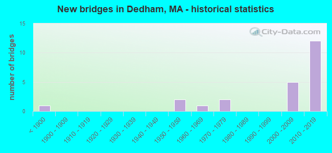
- New bridges - historical statistics
- 1Before 1900
- 21950-1959
- 11960-1969
- 21970-1979
- 52000-2009
- 122010-2019


- Bridge Condition - Deck
- 15.0%Very good
- 70.0%Good
- 5.0%Satisfactory
- 5.0%Fair
- 5.0%Poor

- Bridge Condition - Superstructure
- 38.1%Very good
- 42.9%Good
- 4.8%Satisfactory
- 9.5%Fair
- 4.8%Poor

- Bridge Condition - Substructure
- 9.5%Very good
- 61.9%Good
- 19.0%Satisfactory
- 9.5%Fair

- Bridge Condition - Channel
- 30.0%Very good
- 40.0%Good
- 20.0%Satisfactory
- 10.0%Fair

- Bridge Condition - Culverts
- 50.0%Satisfactory
- 50.0%Fair
Find on map >> Show street view
Structure Number: D0500236KDOTNBI, Location: .1 MI.NE OF NEEDHAM AVE (Lat: 42.267056, Lng: -71.204950), Route carried "on" structure: Other road , Year Built: 1876, Year Reconstructed: 1931, Status: Open, Structure Length: 1.71m (5.61ft), Average Daily Traffic: 5,200 (year 2019), Truck Traffic: 5%, Average Future Daily Traffic: 7,423 (year 2032), Features Intersected: WATER CHARLES RIVER, Facility Carried by Structure: HWY GREENDALE AV
Minimum Vertical Clearance: 30+ m (98+ ft), Kilometerpoint: 0.000, Lanes on structure: 4, Owner: State Highway Agency, Approaching Roadway Width: 12.2m (40.0ft), Material/Design: Masonry, Design/Construction: Arch - Deck, Number Of Spans In Main Unit: 1, Length of Maximum Span: 17.1m (56.1ft), Curb or Sidewalk Widths: Left: 1.4m (4.6ft), Right: 0.6m (2.0ft), Curb-To-Curb Width: 12.2m (40.0ft), Out-to-Out Width: 15.5m (50.9ft)
Condition: Superstructure: Fair, Substructure: Fair, Channel: Fair, Structural Evaluation: Somewhat better than minimum adequacy, Deck Geometry: High priority of replacement, Waterway Adequacy: Better than present minimum criteria, Approach Roadway Alignment: Equal to present desirable criteria, Length Of Structure Improvement: 1.80m (5.91ft), Designated Inspection Frequency: Every 24 months, Underwater Inspection Frequency: Every 36 months, Inspection Date: June 2021, Underwater Inspection Date: April 2019, Bridge Improvement Cost: $1,096,000, Roadway Improvement Cost: $110,000, Total Project Cost: $1,645,000 ( Estimate for 2022), Wearing Surface/Protective System: Wearing Surface: Bituminous
Find on map >> Show street view
Structure Number: D05003BKGMUNNBI, Location: .8 KM E OF RTE 128 (Lat: 42.271025, Lng: -71.190911), Route carried "on" structure: City street , Year Built: 2018, Status: Open, Structure Length: 2.86m (9.38ft), Average Daily Traffic: 22,100 (year 2019), Truck Traffic: 7%, Design Load: HL 93, Features Intersected: WATER GREAT DITCH, Facility Carried by Structure: HWY NEEDHAM ST
Minimum Vertical Clearance: 30+ m (98+ ft), Kilometerpoint: 0.483, Lanes on structure: 2, Owner: Town or Township Highway Agency, Approaching Roadway Width: 9.8m (32.2ft), Material/Design: Prestressed concrete, Design/Construction: Stringer/Multi-beam, Number Of Spans In Main Unit: 1, Length of Maximum Span: 26.8m (87.9ft), Curb or Sidewalk Widths: Left: 1.8m (5.9ft), Right: 0.0m, Curb-To-Curb Width: 9.8m (32.2ft), Out-to-Out Width: 12.4m (40.7ft)
Condition: Deck: Good, Superstructure: Very good, Substructure: Very good, Channel: Very good, Operating Rating: 68.0 metric tons, Method Used To Determine Operating Rating: Load and Resistance Factor Rating (LRFR) rating reported by rating factor(RF) method using HL-93 loadings, Inventory Rating: 48.6 metric tons, Method Used To Determine Inventory Rating: Load and Resistance Factor Rating (LRFR) rating reported by rating factor(RF) method using HL-93 loadings, Structural Evaluation: Equal to present desirable criteria, Deck Geometry: Meets minimum limits, Waterway Adequacy: Better than present minimum criteria, Approach Roadway Alignment: Equal to present minimum criteria, Designated Inspection Frequency: Every 24 months, Inspection Date: August 2021, Deck Structure Type: Concrete Cast-file-Place, Wearing Surface/Protective System: Wearing Surface: Bituminous, Membrane: Epoxy, Deck Protection: Epoxy Coated Reinforcing
Find on map >> Show street view
Structure Number: D05004AX9DOTNBI, Location: 1.3 KM NE OF ST 128 (Lat: 42.254228, Lng: -71.181117), Route carried "on" structure: State highway 109, Year Built: 2012, Status: Open, Structure Length: 3.26m (10.70ft), Average Daily Traffic: 14,700 (year 2018), Truck Traffic: 2%, Design Load: HS 20, Features Intersected: WATER CHARLES RIVER
Minimum Vertical Clearance: 30+ m (98+ ft), Kilometerpoint: 31.719, Lanes on structure: 2, Base Highway Network: Yes, Owner: State Highway Agency, Approaching Roadway Width: 10.0m (32.8ft), Skew: 9 degrees, Material/Design: Concrete continuous, Design/Construction: Slab, Number Of Spans In Main Unit: 3, Length of Maximum Span: 12.1m (39.7ft), Curb or Sidewalk Widths: Left: 0.1m (0.3ft), Right: 0.1m (0.3ft), Curb-To-Curb Width: 9.7m (31.8ft), Out-to-Out Width: 11.0m (36.1ft)
Condition: Deck: Good, Superstructure: Good, Substructure: Satisfactory, Channel: Satisfactory, Operating Rating: 71.5 metric tons, Method Used To Determine Operating Rating: Load Factor (LF), Inventory Rating: 42.8 metric tons, Method Used To Determine Inventory Rating: Load Factor (LF), Structural Evaluation: Equal to present minimum criteria, Deck Geometry: High priority of corrective action, Waterway Adequacy: Better than present minimum criteria, Approach Roadway Alignment: Equal to present desirable criteria, Length Of Structure Improvement: 3.30m (10.83ft), Designated Inspection Frequency: Every 24 months, Underwater Inspection Frequency: Every 36 months, Inspection Date: September 2020, Underwater Inspection Date: April 2021, Bridge Improvement Cost: $1,152,000, Roadway Improvement Cost: $116,000, Total Project Cost: $1,729,000 ( Estimate for 2022), Deck Structure Type: Concrete Precast Panels, Wearing Surface/Protective System: Wearing Surface: Bituminous, Membrane: Built-up, Deck Protection: Epoxy Coated Reinforcing
Find on map >> Show street view
Structure Number: D05005APWMUNNBI, Location: .8 KM SOUTHEAST OF RT. 9 (Lat: 42.252442, Lng: -71.176256), Route carried "on" structure: City street , Year Built: 2012, Status: Open, Structure Length: 3.93m (12.89ft), Average Daily Traffic: 14,400 (year 2020), Truck Traffic: 2%, Design Load: HS 20, Features Intersected: WATER CHARLES RIVER, Facility Carried by Structure: HWY AMES ST
Minimum Vertical Clearance: 99.00m (324.80ft), Kilometerpoint: 0.000, Lanes on structure: 2, Owner: Town or Township Highway Agency, Approaching Roadway Width: 10.0m (32.8ft), Material/Design: Concrete continuous, Design/Construction: Slab, Number Of Spans In Main Unit: 6, Length of Maximum Span: 6.7m (22.0ft), Curb or Sidewalk Widths: Left: 2.0m (6.6ft), Right: 1.8m (5.9ft), Curb-To-Curb Width: 10.0m (32.8ft), Out-to-Out Width: 14.6m (47.9ft)
Condition: Deck: Good, Superstructure: Good, Substructure: Fair, Channel: Good, Operating Rating: 92.7 metric tons, Method Used To Determine Operating Rating: Load Factor (LF), Inventory Rating: 55.5 metric tons, Method Used To Determine Inventory Rating: Load Factor (LF), Structural Evaluation: Somewhat better than minimum adequacy, Deck Geometry: Meets minimum limits, Waterway Adequacy: Equal to present minimum criteria, Approach Roadway Alignment: Equal to present minimum criteria, Length Of Structure Improvement: 4.00m (13.12ft), Designated Inspection Frequency: Every 24 months, Underwater Inspection Frequency: Every 36 months, Inspection Date: Febuary 2020, Underwater Inspection Date: Febuary 2019, Bridge Improvement Cost: $2,294,000, Roadway Improvement Cost: $230,000, Total Project Cost: $3,442,000 ( Estimate for 2022), Deck Structure Type: Concrete Cast-file-Place, Wearing Surface/Protective System: Wearing Surface: Bituminous, Deck Protection: Epoxy Coated Reinforcing
Find on map >> Show street view
Structure Number: D05008342DOTNBI, Location: .5 KM. NE OF US 1 (Lat: 42.255083, Lng: -71.164806), Route carried "on" structure: Alternate State highway 1A, Year Built: 1959, Status: Open, Structure Length: 1.01m (3.31ft), Average Daily Traffic: 38,700 (year 2019), Truck Traffic: 3%, Average Future Daily Traffic: 62,856 (year 2032), Design Load: H 20, Features Intersected: WATER MOTHER BROOK, Facility Carried by Structure: HWY WASHNGTON ST
Minimum Vertical Clearance: 30+ m (98+ ft), Kilometerpoint: 0.000, Lanes on structure: 4, Base Highway Network: Yes, Owner: Town or Township Highway Agency, Approaching Roadway Width: 18.6m (61.0ft), Skew: 20 degrees, Material/Design: Concrete, Design/Construction: Culvert, Number Of Spans In Main Unit: 2, Length of Maximum Span: 4.9m (16.1ft), Curb or Sidewalk Widths: Left: 2.0m (6.6ft), Right: 2.0m (6.6ft), Curb-To-Curb Width: 18.6m (61.0ft), Out-to-Out Width: 24.7m (81.0ft)
Condition: Channel: Satisfactory, Culverts: Fair, Inventory Rating: 74.5 metric tons, Method Used To Determine Inventory Rating: Load Factor (LF), Structural Evaluation: Somewhat better than minimum adequacy, Deck Geometry: Equal to present minimum criteria, Waterway Adequacy: Equal to present desirable criteria, Approach Roadway Alignment: Better than present minimum criteria, Length Of Structure Improvement: 1.90m (6.23ft), Designated Inspection Frequency: Every 24 months, Inspection Date: September 2021, Bridge Improvement Cost: $754,000, Roadway Improvement Cost: $76,000, Total Project Cost: $1,132,000 ( Estimate for 2022), Wearing Surface/Protective System: Wearing Surface: Bituminous
Find on map >> Show street view
Structure Number: D0500933WMUNNBI, Location: 1 KM E OF RT 1 (Lat: 42.248794, Lng: -71.159953), Route carried "on" structure: City street , Year Built: 1958, Status: Open, Structure Length: 0.70m (2.30ft), Average Daily Traffic: 3,000 (year 2018), Truck Traffic: 6%, Average Future Daily Traffic: 12,161 (year 2031), Design Load: H 20, Features Intersected: WATER MOTHER BROOK, Facility Carried by Structure: HWY MAVERICK ST
Minimum Vertical Clearance: 30+ m (98+ ft), Kilometerpoint: 0.805, Lanes on structure: 2, Owner: Town or Township Highway Agency, Approaching Roadway Width: 7.6m (24.9ft), Material/Design: Concrete, Design/Construction: Culvert, Number Of Spans In Main Unit: 1, Length of Maximum Span: 6.1m (20.0ft), Curb or Sidewalk Widths: Left: 1.0m (3.3ft), Right: 1.1m (3.6ft), Curb-To-Curb Width: 7.6m (24.9ft), Out-to-Out Width: 10.8m (35.4ft)
Condition: Channel: Good, Culverts: Satisfactory, Operating Rating: 48.5 metric tons, Method Used To Determine Operating Rating: Allowable Stress (AS), Inventory Rating: 27.0 metric tons, Method Used To Determine Inventory Rating: Allowable Stress (AS), Structural Evaluation: Equal to present minimum criteria, Deck Geometry: High priority of replacement, Waterway Adequacy: Better than present minimum criteria, Approach Roadway Alignment: Meets minimum limits, Length Of Structure Improvement: 0.80m (2.62ft), Designated Inspection Frequency: Every 24 months, Inspection Date: May 2020, Bridge Improvement Cost: $220,000, Roadway Improvement Cost: $23,000, Total Project Cost: $331,000 ( Estimate for 2022)
Find on map >> Show street view
Structure Number: D0501033JMUNNBI, Location: @ INTERSECTION CURVE ST. (Lat: 42.250728, Lng: -71.155589), Route carried "on" structure: City street , Year Built: 1976, Status: Posted for load-capacity, Structure Length: 1.43m (4.69ft), Average Daily Traffic: 12,500 (year 2018), Truck Traffic: 9%, Average Future Daily Traffic: 34,587 (year 2031), Design Load: HS 20, Features Intersected: WATER MOTHER BROOK, Facility Carried by Structure: HWY BUSSEY ST
Minimum Vertical Clearance: 30+ m (98+ ft), Kilometerpoint: 0.322, Lanes on structure: 2, Owner: Town or Township Highway Agency, Approaching Roadway Width: 11.0m (36.1ft), Skew: 2 degrees, Material/Design: Prestressed concrete, Design/Construction: Slab, Number Of Spans In Main Unit: 1, Length of Maximum Span: 13.9m (45.6ft), Curb or Sidewalk Widths: Left: 1.9m (6.2ft), Right: 2.0m (6.6ft), Curb-To-Curb Width: 11.0m (36.1ft), Out-to-Out Width: 15.8m (51.8ft)
Condition: Deck: Poor, Superstructure: Poor, Substructure: Good, Channel: Good, Operating Rating: 29.2 metric tons, Method Used To Determine Operating Rating: Load Factor (LF), Inventory Rating: 22.6 metric tons, Method Used To Determine Inventory Rating: Allowable Stress (AS), Structural Evaluation: Meets minimum limits, Deck Geometry: Meets minimum limits, Waterway Adequacy: Better than present minimum criteria, Approach Roadway Alignment: Equal to present minimum criteria, Bridge Posting: Required (Relationship of Operating Rating to Maximum Legal Load: 0.1 - 9.9% below), Length Of Structure Improvement: 2.20m (7.22ft), Designated Inspection Frequency: Every 12 months, Underwater Inspection Frequency: Every 36 months, Other Special Inspection Frequency: Every 12 months, Inspection Date: May 2020, Underwater Inspection Date: Febuary 2020, Other Special Inspection Date: May 2021, Bridge Improvement Cost: $2,098,000, Roadway Improvement Cost: $210,000, Total Project Cost: $3,148,000 ( Estimate for 2022), Deck Structure Type: Concrete Precast Panels, Wearing Surface/Protective System: Wearing Surface: Bituminous, Membrane: Built-up
Find on map >> Show street view
Structure Number: D05011ATPMUNNBI, Location: 1.4 KM E OF RT 1 (Lat: 42.247975, Lng: -71.152908), Route carried "on" structure: City street , Year Built: 2002, Status: Open, Structure Length: 3.16m (10.37ft), Average Daily Traffic: 16,500 (year 2018), Truck Traffic: 4%, Average Future Daily Traffic: 44,220 (year 2031), Design Load: HS 20, Features Intersected: WATER MOTHER BROOK, Facility Carried by Structure: HWY SAW MILL LN
Minimum Vertical Clearance: 30+ m (98+ ft), Kilometerpoint: 0.145, Lanes on structure: 2, Owner: Town or Township Highway Agency, Approaching Roadway Width: 9.2m (30.2ft), Material/Design: Prestressed concrete, Design/Construction: Box Beam or Girders - Multiple, Number Of Spans In Main Unit: 1, Length of Maximum Span: 30.4m (99.7ft), Curb or Sidewalk Widths: Left: 1.9m (6.2ft), Right: 2.0m (6.6ft), Curb-To-Curb Width: 9.2m (30.2ft), Out-to-Out Width: 18.2m (59.7ft)
Condition: Deck: Very good, Superstructure: Very good, Substructure: Satisfactory, Channel: Very good, Operating Rating: 53.8 metric tons, Method Used To Determine Operating Rating: Load Factor (LF), Inventory Rating: 32.4 metric tons, Method Used To Determine Inventory Rating: Load Factor (LF), Structural Evaluation: Equal to present minimum criteria, Deck Geometry: High priority of corrective action, Waterway Adequacy: Better than present minimum criteria, Approach Roadway Alignment: Better than present minimum criteria, Length Of Structure Improvement: 3.20m (10.50ft), Designated Inspection Frequency: Every 24 months, Inspection Date: October 2020, Bridge Improvement Cost: $1,268,000, Roadway Improvement Cost: $127,000, Total Project Cost: $1,903,000 ( Estimate for 2022), Deck Structure Type: Concrete Precast Panels, Wearing Surface/Protective System: Wearing Surface: Bituminous, Membrane: Built-up, Deck Protection: Epoxy Coated Reinforcing
Find on map >> Show street view
Structure Number: D05018374DOT634, Location: .32 KM NE GREENLODGE ST (Lat: 42.235094, Lng: -71.151989), Route carried "on" structure: City street , Year Built: 1961, Status: Open, Structure Length: 1.49m (4.89ft), Average Daily Traffic: 18,600 (year 2019), Truck Traffic: 4%, Average Future Daily Traffic: 20,215 (year 2032), Design Load: H 20, Features Intersected: RR MBTA/CSX, Facility Carried by Structure: HWY CEDAR ST
Minimum Vertical Clearance: 30+ m (98+ ft), Kilometerpoint: 0.000, Lanes on structure: 2, Owner: State Highway Agency, Approaching Roadway Width: 9.2m (30.2ft), Skew: 4 degrees, Material/Design: Prestressed concrete, Design/Construction: Slab, Number Of Spans In Main Unit: 1, Length of Maximum Span: 13.9m (45.6ft), Curb or Sidewalk Widths: Left: 1.7m (5.6ft), Right: 1.7m (5.6ft), Curb-To-Curb Width: 9.2m (30.2ft), Out-to-Out Width: 12.9m (42.3ft)
Condition: Deck: Fair, Superstructure: Fair, Substructure: Satisfactory, Operating Rating: 36.2 metric tons, Method Used To Determine Operating Rating: Load Factor (LF), Inventory Rating: 26.0 metric tons, Method Used To Determine Inventory Rating: Load Factor (LF), Structural Evaluation: Somewhat better than minimum adequacy, Deck Geometry: High priority of corrective action, Underclear: High priority of corrective action, Approach Roadway Alignment: Equal to present minimum criteria, Length Of Structure Improvement: 1.50m (4.92ft), Designated Inspection Frequency: Every 24 months, Inspection Date: July 2021, Bridge Improvement Cost: $761,000, Roadway Improvement Cost: $77,000, Total Project Cost: $1,142,000 ( Estimate for 2022), Deck Structure Type: Concrete Precast Panels, Wearing Surface/Protective System: Wearing Surface: Bituminous, Membrane: Preformed Fabric
Find on map >> Show street view
Structure Number: D05021372DOT634, Location: .16 KM S OF MILTON ST (Lat: 42.244856, Lng: -71.155133), Route carried "on" structure: City street , Year Built: 1976, Status: Open, Structure Length: 2.03m (6.66ft), Average Daily Traffic: 12,500 (year 2022), Truck Traffic: 7%, Average Future Daily Traffic: 16,109 (year 2033), Design Load: H 20, Features Intersected: RR CSX, Facility Carried by Structure: HWY WALNUT ST
Minimum Vertical Clearance: 30+ m (98+ ft), Kilometerpoint: 0.000, Lanes on structure: 2, Owner: State Highway Agency, Approaching Roadway Width: 8.2m (26.9ft), Skew: 1 degrees, Material/Design: Prestressed concrete, Design/Construction: Box Beam or Girders - Multiple, Number Of Spans In Main Unit: 1, Length of Maximum Span: 18.6m (61.0ft), Curb or Sidewalk Widths: Left: 1.8m (5.9ft), Right: 1.8m (5.9ft), Curb-To-Curb Width: 8.2m (26.9ft), Out-to-Out Width: 12.8m (42.0ft)
Condition: Deck: Satisfactory, Superstructure: Satisfactory, Substructure: Satisfactory, Operating Rating: 55.4 metric tons, Method Used To Determine Operating Rating: Allowable Stress (AS), Inventory Rating: 26.0 metric tons, Method Used To Determine Inventory Rating: Allowable Stress (AS), Structural Evaluation: Equal to present minimum criteria, Deck Geometry: High priority of replacement, Underclear: High priority of corrective action, Approach Roadway Alignment: Better than present minimum criteria, Length Of Structure Improvement: 2.10m (6.89ft), Designated Inspection Frequency: Every 24 months, Inspection Date: January 2022, Bridge Improvement Cost: $1,056,000, Roadway Improvement Cost: $106,000, Total Project Cost: $1,585,000 ( Estimate for 2022), Deck Structure Type: Concrete Precast Panels, Wearing Surface/Protective System: Wearing Surface: Bituminous, Membrane: Built-up, Deck Protection: Internally Sealed
Find on map >> Show street view
Structure Number: D05027B1FDOTNBI, Location: AT US1 AND I95 (Lat: 42.228531, Lng: -71.181744), Route carried "on" structure: US 1, Year Built: 2009, Status: Open, Structure Length: 10.10m (33.14ft), Average Daily Traffic: 102,500 (year 2019), Truck Traffic: 5%, Average Future Daily Traffic: 173,723 (year 2032), Design Load: HS 20, Features Intersected: I 95 /ST 128
Minimum Vertical Clearance: 0.00m, Kilometerpoint: 42.164, Lanes on structure: 6, Lanes under structure: 10, Owner: State Highway Agency, Approaching Roadway Width: 25.7m (84.3ft), Skew: 33 degrees, Material/Design: Steel continuous, Design/Construction: Stringer/Multi-beam, Number Of Spans In Main Unit: 2, Length of Maximum Span: 53.0m (173.9ft), Curb or Sidewalk Widths: Left: 1.7m (5.6ft), Right: 1.7m (5.6ft), Curb-To-Curb Width: 25.7m (84.3ft), Out-to-Out Width: 30.9m (101.4ft)
Condition: Deck: Good, Superstructure: Good, Substructure: Good, Operating Rating: 92.0 metric tons, Method Used To Determine Operating Rating: Load Factor (LF), Inventory Rating: 55.1 metric tons, Method Used To Determine Inventory Rating: Load Factor (LF), Structural Evaluation: Better than present minimum criteria, Deck Geometry: Somewhat better than minimum adequacy, Underclear: Somewhat better than minimum adequacy, Approach Roadway Alignment: Equal to present desirable criteria, Length Of Structure Improvement: 10.20m (33.46ft), Designated Inspection Frequency: Every 24 months, Inspection Date: June 2021, Bridge Improvement Cost: $3,655,000, Roadway Improvement Cost: $366,000, Total Project Cost: $5,483,000 ( Estimate for 2022), Deck Structure Type: Concrete Cast-file-Place, Wearing Surface/Protective System: Wearing Surface: Bituminous, Membrane: Built-up, Deck Protection: Epoxy Coated Reinforcing
Find on map >> Show street view
Structure Number: D05029AGUDOTNBI, Location: PROVIDENCE HWY & WASH. ST (Lat: 42.248736, Lng: -71.171083), Route carried "on" structure: US , Year Built: 2010, Status: Open, Structure Length: 10.82m (35.50ft), Average Daily Traffic: 49,000 (year 2019), Truck Traffic: 5%, Average Future Daily Traffic: 85,914 (year 2032), Design Load: HS 25 or greater, Features Intersected: ST135 HIGH & HARRIS STS, Facility Carried by Structure: HWY PROVDNCE HWY
Minimum Vertical Clearance: 0.00m, Kilometerpoint: 0.000, Lanes on structure: 5, Lanes under structure: 4, Base Highway Network: Yes, Owner: State Highway Agency, Approaching Roadway Width: 21.9m (71.9ft), Skew: 31 degrees, Material/Design: Prestressed concrete, Design/Construction: Tee Beam, Number Of Spans In Main Unit: 3, Length of Maximum Span: 37.5m (123.0ft), Curb or Sidewalk Widths: Left: 1.5m (4.9ft), Right: 1.5m (4.9ft), Curb-To-Curb Width: 21.9m (71.9ft), Out-to-Out Width: 25.7m (84.3ft)
Condition: Deck: Good, Superstructure: Very good, Substructure: Good, Operating Rating: 77.8 metric tons, Method Used To Determine Operating Rating: Load Factor (LF), Inventory Rating: 45.4 metric tons, Method Used To Determine Inventory Rating: Load Factor (LF), Structural Evaluation: Better than present minimum criteria, Deck Geometry: High priority of replacement, Underclear: High priority of replacement, Approach Roadway Alignment: Equal to present minimum criteria, Length Of Structure Improvement: 11.80m (38.71ft), Designated Inspection Frequency: Every 24 months, Inspection Date: March 2021, Bridge Improvement Cost: $18,296,000, Roadway Improvement Cost: $1,830,000, Total Project Cost: $27,445,000 ( Estimate for 2022), Deck Structure Type: Concrete Cast-file-Place, Wearing Surface/Protective System: Wearing Surface: Integral Concrete
Find on map >> Show street view
Structure Number: D05033BABDOTNBI, Location: .32 KM. N OF ST 1A (Lat: 42.255092, Lng: -71.171056), Route carried "on" structure: State highway 1, Year Built: 2017, Status: Open, Structure Length: 2.07m (6.79ft), Average Daily Traffic: 34,655 (year 2020), Truck Traffic: 10%, Design Load: HL 93, Features Intersected: WATER MOTHER BROOK, Facility Carried by Structure: HWY PROVDNCE HWY
Minimum Vertical Clearance: 30+ m (98+ ft), Kilometerpoint: 0.000, Lanes on structure: 4, Owner: State Highway Agency, Approaching Roadway Width: 21.9m (71.9ft), Skew: 33 degrees, Material/Design: Steel, Design/Construction: Stringer/Multi-beam, Number Of Spans In Main Unit: 1, Length of Maximum Span: 20.7m (67.9ft), Curb or Sidewalk Widths: Left: 2.0m (6.6ft), Right: 2.0m (6.6ft), Curb-To-Curb Width: 27.4m (89.9ft), Out-to-Out Width: 32.2m (105.6ft)
Condition: Deck: Very good, Superstructure: Very good, Substructure: Very good, Channel: Very good, Operating Rating: 42.1 metric tons, Method Used To Determine Operating Rating: Assigned ratings based on Load and Resistance Factor Design (LRFD) reported by rating factor (RF) using HL93 loadings, Inventory Rating: 32.4 metric tons, Method Used To Determine Inventory Rating: Assigned ratings based on Load and Resistance Factor Design (LRFD) reported by rating factor (RF) using HL93 loadings, Structural Evaluation: Equal to present desirable criteria, Deck Geometry: Superior to present desirable criteria, Waterway Adequacy: Equal to present minimum criteria, Approach Roadway Alignment: Equal to present desirable criteria, Designated Inspection Frequency: Every 24 months, Inspection Date: Febuary 2020, Deck Structure Type: Concrete Cast-file-Place, Wearing Surface/Protective System: Wearing Surface: Bituminous, Membrane: Built-up, Deck Protection: Epoxy Coated Reinforcing
Find on map >> Show street view
Structure Number: D05038B3EDOTNBI, Location: .16KM SW GRT PLAIN AVE. (Lat: 42.267328, Lng: -71.202544), Route carried "on" structure: Interstate 95, Year Built: 2014, Status: Open, Structure Length: 9.76m (32.02ft), Average Daily Traffic: 89,190 (year 2018), Truck Traffic: 6%, Design Load: HS 25 or greater, Features Intersected: WATER CHARLES RIVER
Minimum Vertical Clearance: 30+ m (98+ ft), Kilometerpoint: 0.000, Lanes on structure: 5, Owner: State Highway Agency, Approaching Roadway Width: 25.8m (84.6ft), Skew: 4 degrees, Material/Design: Steel continuous, Design/Construction: Stringer/Multi-beam, Number Of Spans In Main Unit: 3, Length of Maximum Span: 36.0m (118.1ft), Curb-To-Curb Width: 24.8m (81.4ft), Out-to-Out Width: 25.8m (84.6ft)
Condition: Deck: Good, Superstructure: Good, Substructure: Good, Channel: Good, Structural Evaluation: Better than present minimum criteria, Deck Geometry: Better than present minimum criteria, Waterway Adequacy: Superior to present desirable criteria, Approach Roadway Alignment: Equal to present desirable criteria, Designated Inspection Frequency: Every 24 months, Inspection Date: June 2021, Deck Structure Type: Concrete Cast-file-Place, Wearing Surface/Protective System: Wearing Surface: Bituminous, Membrane: Built-up, Deck Protection: Epoxy Coated Reinforcing
Find on map >> Show street view
Structure Number: D05040B2CDOTNBI, Location: I 95 AT ST 135 (Lat: 42.264111, Lng: -71.205417), Route carried "on" structure: Interstate 95, Year Built: 2014, Status: Open, Structure Length: 1.69m (5.54ft), Average Daily Traffic: 58,419 (year 2020), Truck Traffic: 7%, Design Load: HS 25 or greater, Features Intersected: ST135 WEST ST
Minimum Vertical Clearance: 30+ m (98+ ft), Kilometerpoint: 20.438, Lanes on structure: 5, Lanes under structure: 2, Base Highway Network: Yes, Owner: State Highway Agency, Approaching Roadway Width: 23.3m (76.4ft), Material/Design: Steel, Design/Construction: Stringer/Multi-beam, Number Of Spans In Main Unit: 1, Length of Maximum Span: 16.9m (55.4ft), Curb-To-Curb Width: 23.3m (76.4ft), Out-to-Out Width: 24.4m (80.1ft)
Condition: Deck: Good, Superstructure: Very good, Substructure: Good, Operating Rating: 91.4 metric tons, Method Used To Determine Operating Rating: Load Factor (LF), Inventory Rating: 54.7 metric tons, Method Used To Determine Inventory Rating: Load Factor (LF), Structural Evaluation: Better than present minimum criteria, Deck Geometry: Somewhat better than minimum adequacy, Underclear: Somewhat better than minimum adequacy, Approach Roadway Alignment: Equal to present desirable criteria, Designated Inspection Frequency: Every 24 months, Inspection Date: December 2021, Deck Structure Type: Concrete Cast-file-Place, Wearing Surface/Protective System: Wearing Surface: Monolithic Concrete
Find on map >> Show street view
Structure Number: D05041B2DDOTNBI, Location: I 95 AT ST 135 (Lat: 42.264694, Lng: -71.206750), Route carried "on" structure: Interstate 95, Year Built: 2014, Status: Open, Structure Length: 1.69m (5.54ft), Average Daily Traffic: 57,881 (year 2020), Truck Traffic: 7%, Design Load: HS 25 or greater, Features Intersected: ST135 WEST ST
Minimum Vertical Clearance: 30+ m (98+ ft), Kilometerpoint: 20.438, Lanes on structure: 4, Lanes under structure: 2, Base Highway Network: Yes, Owner: State Highway Agency, Approaching Roadway Width: 23.3m (76.4ft), Material/Design: Steel, Design/Construction: Stringer/Multi-beam, Number Of Spans In Main Unit: 1, Length of Maximum Span: 16.9m (55.4ft), Curb-To-Curb Width: 23.3m (76.4ft), Out-to-Out Width: 24.4m (80.1ft)
Condition: Deck: Good, Superstructure: Very good, Substructure: Good, Operating Rating: 95.0 metric tons, Method Used To Determine Operating Rating: Load Factor (LF), Inventory Rating: 56.9 metric tons, Method Used To Determine Inventory Rating: Load Factor (LF), Structural Evaluation: Better than present minimum criteria, Deck Geometry: Superior to present desirable criteria, Underclear: Somewhat better than minimum adequacy, Approach Roadway Alignment: Equal to present desirable criteria, Designated Inspection Frequency: Every 24 months, Inspection Date: December 2021, Deck Structure Type: Concrete Cast-file-Place, Wearing Surface/Protective System: Wearing Surface: Monolithic Concrete, Deck Protection: Epoxy Coated Reinforcing
Find on map >> Show street view
Structure Number: D05042B1MDOTNBI, Location: 109 AT I-95 NB (Lat: 42.244519, Lng: -71.201781), Route carried "on" structure: State highway 109, Year Built: 2015, Status: Open, Structure Length: 3.60m (11.81ft), Average Daily Traffic: 32,600 (year 2018), Truck Traffic: 5%, Design Load: HS 25 or greater, Features Intersected: I 95 /128 NB
Minimum Vertical Clearance: 99.00m (324.80ft), Kilometerpoint: 29.590, Lanes on structure: 4, Lanes under structure: 4, Base Highway Network: Yes, Owner: State Highway Agency, Approaching Roadway Width: 23.4m (76.8ft), Skew: 21 degrees, Material/Design: Steel, Design/Construction: Stringer/Multi-beam, Number Of Spans In Main Unit: 1, Length of Maximum Span: 35.4m (116.1ft), Curb or Sidewalk Widths: Left: 0.3m (1.0ft), Right: 1.6m (5.2ft), Curb-To-Curb Width: 23.5m (77.1ft), Out-to-Out Width: 25.9m (85.0ft)
Condition: Deck: Good, Superstructure: Good, Substructure: Good, Operating Rating: 99.0 metric tons, Method Used To Determine Operating Rating: Load Factor (LF), Inventory Rating: 59.3 metric tons, Method Used To Determine Inventory Rating: Load Factor (LF), Structural Evaluation: Better than present minimum criteria, Deck Geometry: Superior to present desirable criteria, Underclear: High priority of corrective action, Approach Roadway Alignment: Equal to present desirable criteria, Designated Inspection Frequency: Every 24 months, Inspection Date: June 2020, Deck Structure Type: Concrete Cast-file-Place, Wearing Surface/Protective System: Wearing Surface: Bituminous, Membrane: Built-up
Find on map >> Show street view
Structure Number: D05043B1NDOTNBI, Location: 109 AT 95 (Lat: 42.243314, Lng: -71.205153), Route carried "on" structure: State highway 109, Year Built: 2015, Status: Open, Structure Length: 3.43m (11.25ft), Average Daily Traffic: 32,600 (year 2018), Truck Traffic: 5%, Design Load: HS 25 or greater, Features Intersected: I 95 SB/128 SB
Minimum Vertical Clearance: 99.00m (324.80ft), Kilometerpoint: 29.590, Lanes on structure: 4, Lanes under structure: 4, Base Highway Network: Yes, Owner: State Highway Agency, Approaching Roadway Width: 23.4m (76.8ft), Skew: 22 degrees, Material/Design: Steel, Design/Construction: Stringer/Multi-beam, Number Of Spans In Main Unit: 1, Length of Maximum Span: 33.5m (109.9ft), Curb or Sidewalk Widths: Left: 0.4m (1.3ft), Right: 1.6m (5.2ft), Curb-To-Curb Width: 23.5m (77.1ft), Out-to-Out Width: 26.0m (85.3ft)
Condition: Deck: Good, Superstructure: Good, Substructure: Good, Inventory Rating: 68.6 metric tons, Method Used To Determine Inventory Rating: Load Factor (LF), Structural Evaluation: Better than present minimum criteria, Deck Geometry: Superior to present desirable criteria, Underclear: High priority of corrective action, Approach Roadway Alignment: Equal to present desirable criteria, Designated Inspection Frequency: Every 24 months, Inspection Date: June 2020, Deck Structure Type: Concrete Cast-file-Place, Wearing Surface/Protective System: Wearing Surface: Bituminous, Membrane: Built-up
Find on map >> Show street view
Structure Number: D05044B1GDOTNBI, Location: US 1A AT ST 128 (Lat: 42.231397, Lng: -71.184936), Route carried "on" structure: Alternate State highway 1A, Year Built: 2010, Status: Open, Structure Length: 3.51m (11.52ft), Average Daily Traffic: 30,500 (year 2019), Truck Traffic: 2%, Average Future Daily Traffic: 34,903 (year 2032), Design Load: HS 25 or greater, Features Intersected: I 95 NB/ST 128 NB, Facility Carried by Structure: ST 1 A/WASHINGTON
Minimum Vertical Clearance: 30+ m (98+ ft), Kilometerpoint: 4.313, Lanes on structure: 4, Lanes under structure: 4, Owner: State Highway Agency, Approaching Roadway Width: 16.6m (54.5ft), Skew: 2 degrees, Material/Design: Steel, Design/Construction: Stringer/Multi-beam, Number Of Spans In Main Unit: 1, Length of Maximum Span: 33.0m (108.3ft), Curb or Sidewalk Widths: Left: 1.7m (5.6ft), Right: 1.7m (5.6ft), Curb-To-Curb Width: 16.6m (54.5ft), Out-to-Out Width: 20.7m (67.9ft)
Condition: Deck: Good, Superstructure: Good, Substructure: Good, Operating Rating: 95.1 metric tons, Method Used To Determine Operating Rating: Load Factor (LF), Inventory Rating: 56.9 metric tons, Method Used To Determine Inventory Rating: Load Factor (LF), Structural Evaluation: Better than present minimum criteria, Deck Geometry: Somewhat better than minimum adequacy, Underclear: High priority of corrective action, Approach Roadway Alignment: Better than present minimum criteria, Length Of Structure Improvement: 3.60m (11.81ft), Designated Inspection Frequency: Every 24 months, Inspection Date: June 2021, Bridge Improvement Cost: $1,867,000, Roadway Improvement Cost: $187,000, Total Project Cost: $2,801,000 ( Estimate for 2022), Deck Structure Type: Concrete Cast-file-Place, Wearing Surface/Protective System: Wearing Surface: Bituminous, Membrane: Built-up, Deck Protection: Epoxy Coated Reinforcing
Find on map >> Show street view
Structure Number: D05045B1HDOTNBI, Location: US 1A AT ST 128 (Lat: 42.230789, Lng: -71.185267), Route carried "on" structure: Alternate State highway 1A, Year Built: 2010, Status: Open, Structure Length: 3.51m (11.52ft), Average Daily Traffic: 30,500 (year 2019), Truck Traffic: 2%, Average Future Daily Traffic: 34,903 (year 2032), Design Load: HS 25 or greater, Features Intersected: I 95 SB/ST 128 SB, Facility Carried by Structure: ST 1 A/WASHINGTON
Minimum Vertical Clearance: 30+ m (98+ ft), Kilometerpoint: 4.313, Lanes on structure: 4, Lanes under structure: 4, Owner: State Highway Agency, Approaching Roadway Width: 16.6m (54.5ft), Skew: 2 degrees, Material/Design: Steel, Design/Construction: Stringer/Multi-beam, Number Of Spans In Main Unit: 1, Length of Maximum Span: 33.0m (108.3ft), Curb or Sidewalk Widths: Left: 1.7m (5.6ft), Right: 1.7m (5.6ft), Curb-To-Curb Width: 16.6m (54.5ft), Out-to-Out Width: 20.7m (67.9ft)
Condition: Deck: Good, Superstructure: Good, Substructure: Good, Operating Rating: 95.1 metric tons, Method Used To Determine Operating Rating: Load Factor (LF), Inventory Rating: 56.9 metric tons, Method Used To Determine Inventory Rating: Load Factor (LF), Structural Evaluation: Better than present minimum criteria, Deck Geometry: Somewhat better than minimum adequacy, Underclear: High priority of corrective action, Approach Roadway Alignment: Equal to present desirable criteria, Length Of Structure Improvement: 3.60m (11.81ft), Designated Inspection Frequency: Every 24 months, Inspection Date: June 2021, Bridge Improvement Cost: $1,867,000, Roadway Improvement Cost: $187,000, Total Project Cost: $2,801,000 ( Estimate for 2022), Deck Structure Type: Concrete Cast-file-Place, Wearing Surface/Protective System: Wearing Surface: Bituminous, Membrane: Built-up, Deck Protection: Epoxy Coated Reinforcing
Find on map >> Show street view
Structure Number: D050478FUDOTNBI, Location: AT RR STATION (Lat: 42.211153, Lng: -71.146722), Route carried "on" structure: Interstate 95, Year Built: 2008, Status: Open, Structure Length: 7.18m (23.56ft), Average Daily Traffic: 169,809 (year 2018), Truck Traffic: 11%, Average Future Daily Traffic: 260,584 (year 2032), Design Load: HS 20, Features Intersected: RR AMTRAK/MBTA
Minimum Vertical Clearance: 30+ m (98+ ft), Kilometerpoint: 0.000, Lanes on structure: 5, Owner: State Highway Agency, Approaching Roadway Width: 24.7m (81.0ft), Skew: 1 degrees, Material/Design: Steel continuous, Design/Construction: Stringer/Multi-beam, Number Of Spans In Main Unit: 4, Length of Maximum Span: 19.8m (65.0ft), Curb-To-Curb Width: 24.7m (81.0ft), Out-to-Out Width: 25.8m (84.6ft)
Condition: Deck: Good, Superstructure: Very good, Substructure: Good, Operating Rating: 91.0 metric tons, Method Used To Determine Operating Rating: Load Factor (LF), Inventory Rating: 54.4 metric tons, Method Used To Determine Inventory Rating: Load Factor (LF), Structural Evaluation: Better than present minimum criteria, Deck Geometry: Better than present minimum criteria, Underclear: High priority of corrective action, Approach Roadway Alignment: Better than present minimum criteria, Length Of Structure Improvement: 7.20m (23.62ft), Designated Inspection Frequency: Every 24 months, Inspection Date: October 2021, Bridge Improvement Cost: $747,000, Roadway Improvement Cost: $75,000, Total Project Cost: $1,121,000 ( Estimate for 2022), Deck Structure Type: Concrete Cast-file-Place, Wearing Surface/Protective System: Wearing Surface: Bituminous, Membrane: Built-up, Deck Protection: Epoxy Coated Reinforcing
Find on map >> Show street view
Structure Number: D050478FVDOTNBI, Location: AT RR STATION (Lat: 42.211369, Lng: -71.146661), Route carried "on" structure: Interstate 95, Year Built: 2008, Status: Open, Structure Length: 7.18m (23.56ft), Average Daily Traffic: 205,138 (year 2018), Truck Traffic: 11%, Average Future Daily Traffic: 260,584 (year 2032), Design Load: HS 20, Features Intersected: RR AMTRAK/MBTA
Minimum Vertical Clearance: 30+ m (98+ ft), Kilometerpoint: 0.000, Lanes on structure: 4, Owner: State Highway Agency, Approaching Roadway Width: 24.7m (81.0ft), Skew: 1 degrees, Material/Design: Steel continuous, Design/Construction: Stringer/Multi-beam, Number Of Spans In Main Unit: 4, Length of Maximum Span: 19.8m (65.0ft), Curb-To-Curb Width: 24.7m (81.0ft), Out-to-Out Width: 25.8m (84.6ft)
Condition: Deck: Very good, Superstructure: Very good, Substructure: Good, Operating Rating: 90.7 metric tons, Method Used To Determine Operating Rating: Load Factor (LF), Inventory Rating: 53.5 metric tons, Method Used To Determine Inventory Rating: Load Factor (LF), Structural Evaluation: Better than present minimum criteria, Deck Geometry: Superior to present desirable criteria, Underclear: High priority of corrective action, Approach Roadway Alignment: Better than present minimum criteria, Length Of Structure Improvement: 7.20m (23.62ft), Designated Inspection Frequency: Every 24 months, Inspection Date: October 2021, Bridge Improvement Cost: $730,000, Roadway Improvement Cost: $74,000, Total Project Cost: $1,096,000 ( Estimate for 2022), Deck Structure Type: Concrete Cast-file-Place, Wearing Surface/Protective System: Wearing Surface: Bituminous, Membrane: Built-up, Deck Protection: Epoxy Coated Reinforcing
Find on map >> Show street view
Structure Number: D05048AXGDOTNBI, Location: JUST NORTH OF RR STATION (Lat: 42.212594, Lng: -71.149031), Route carried "on" structure: Interstate 95, Year Built: 2008, Status: Open, Structure Length: 4.11m (13.48ft), Average Daily Traffic: 179,566 (year 2018), Truck Traffic: 6%, Average Future Daily Traffic: 253,004 (year 2032), Design Load: HS 20, Features Intersected: HWY UNIVERSITY AVE
Minimum Vertical Clearance: 30+ m (98+ ft), Kilometerpoint: 0.000, Lanes on structure: 10, Lanes under structure: 2, Owner: State Highway Agency, Approaching Roadway Width: 49.4m (162.1ft), Skew: 31 degrees, Material/Design: Steel continuous, Design/Construction: Stringer/Multi-beam, Number Of Spans In Main Unit: 3, Length of Maximum Span: 17.7m (58.1ft), Curb-To-Curb Width: 49.4m (162.1ft), Out-to-Out Width: 51.6m (169.3ft)
Condition: Deck: Good, Superstructure: Good, Substructure: Good, Operating Rating: 76.8 metric tons, Method Used To Determine Operating Rating: Load Factor (LF), Inventory Rating: 45.7 metric tons, Method Used To Determine Inventory Rating: Load Factor (LF), Structural Evaluation: Better than present minimum criteria, Deck Geometry: Superior to present desirable criteria, Underclear: Meets minimum limits, Approach Roadway Alignment: Better than present minimum criteria, Length Of Structure Improvement: 4.20m (13.78ft), Designated Inspection Frequency: Every 24 months, Inspection Date: August 2021, Bridge Improvement Cost: $852,000, Roadway Improvement Cost: $86,000, Total Project Cost: $1,279,000 ( Estimate for 2022), Deck Structure Type: Concrete Cast-file-Place, Wearing Surface/Protective System: Wearing Surface: Bituminous, Membrane: Built-up, Deck Protection: Epoxy Coated Reinforcing