Bridge Statistics for Deerfield Beach, Florida (FL)
Condition, Traffic, Stress, Structural Evaluation, Project Costs
- National Bridge Inventory (NBI) Statistics
- 38Number of bridges
- 604ft / 184mTotal length
- $190,000Total costs
- 1,581,121Total average daily traffic
- 130,043Total average daily truck traffic
- National Bridge Inventory (NBI) Registered Bridges for Deerfield Beach
- No street view available for this location
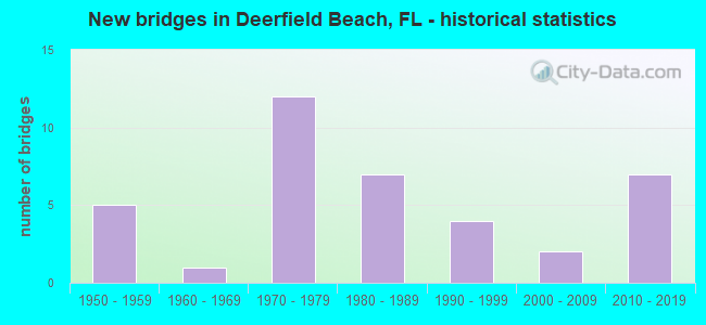
- New bridges - historical statistics
- 51950-1959
- 11960-1969
- 121970-1979
- 71980-1989
- 41990-1999
- 22000-2009
- 72010-2019
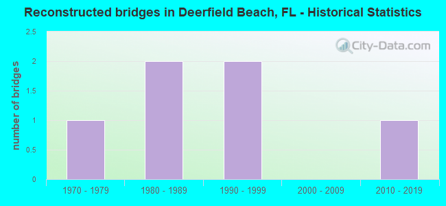
- Reconstructed bridges - Historical Statistics
- 11970-1979
- 21980-1989
- 21990-1999
- 02000-2009
- 12010-2019
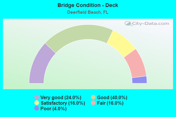
- Bridge Condition - Deck
- 24.0%Very good
- 40.0%Good
- 16.0%Satisfactory
- 16.0%Fair
- 4.0%Poor
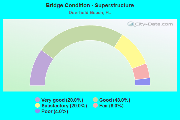
- Bridge Condition - Superstructure
- 20.0%Very good
- 48.0%Good
- 20.0%Satisfactory
- 8.0%Fair
- 4.0%Poor
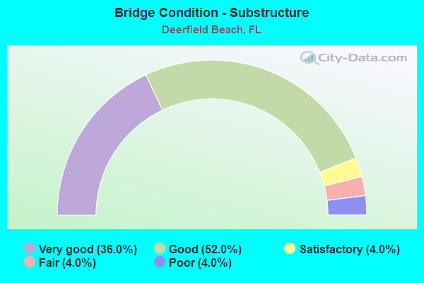
- Bridge Condition - Substructure
- 36.0%Very good
- 52.0%Good
- 4.0%Satisfactory
- 4.0%Fair
- 4.0%Poor
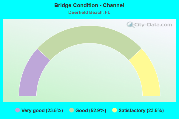
- Bridge Condition - Channel
- 23.5%Very good
- 52.9%Good
- 23.5%Satisfactory
Find on map >> Show street view
Structure Number: 860122, Location: 1mi N of SR834(Sample Rd) (Lat: 26.289764, Lng: -80.123908), Route carried "on" structure: City street , Year Built: 1973, Status: Open, Structure Length: 8.29m (27.20ft), Average Daily Traffic: 22,000 (year 2020), Truck Traffic: 9%, Average Future Daily Traffic: 38,170 (year 2042), Design Load: HS 20+Mod, Features Intersected: I-95 (SR-9), Facility Carried by Structure: NE 48 Street
Minimum Vertical Clearance: 30+ m (98+ ft), Kilometerpoint: 2.889, Lanes on structure: 4, Lanes under structure: 10, Owner: State Highway Agency, Approaching Roadway Width: 26.1m (85.6ft), Skew: 21 degrees, Material/Design: Prestressed concrete, Design/Construction: Stringer/Multi-beam, Number Of Spans In Main Unit: 4, Length of Maximum Span: 31.7m (104.0ft), Curb or Sidewalk Widths: Left: 1.6m (5.2ft), Right: 1.5m (4.9ft), Curb-To-Curb Width: 21.1m (69.2ft), Out-to-Out Width: 29.8m (97.8ft)
Condition: Deck: Good, Superstructure: Satisfactory, Substructure: Good, Operating Rating: 35.3 metric tons, Method Used To Determine Operating Rating: Load and Resistance Factor (LRFR), Inventory Rating: 28.1 metric tons, Method Used To Determine Inventory Rating: Load and Resistance Factor (LRFR), Structural Evaluation: Equal to present minimum criteria, Deck Geometry: Superior to present desirable criteria, Underclear: Somewhat better than minimum adequacy, Approach Roadway Alignment: Equal to present desirable criteria, Designated Inspection Frequency: Every 24 months, Inspection Date: June 2020, Deck Structure Type: Concrete Cast-file-Place
Find on map >> Show street view
Structure Number: 860123, Location: 1.0 Mi W of SR-811 (Lat: 26.304575, Lng: -80.119583), Route carried "on" structure: State highway 869, Year Built: 1972, Status: Open, Structure Length: 8.29m (27.20ft), Average Daily Traffic: 52,000 (year 2020), Truck Traffic: 8%, Average Future Daily Traffic: 90,220 (year 2042), Design Load: HS 20, Features Intersected: I-95 (SR-9)
Minimum Vertical Clearance: 30+ m (98+ ft), Kilometerpoint: 3.256, Lanes on structure: 7, Lanes under structure: 9, Base Highway Network: Yes, Owner: State Highway Agency, Approaching Roadway Width: 26.1m (85.6ft), Skew: 21 degrees, Material/Design: Prestressed concrete, Design/Construction: Stringer/Multi-beam, Number Of Spans In Main Unit: 4, Length of Maximum Span: 31.7m (104.0ft), Curb or Sidewalk Widths: Left: 1.6m (5.2ft), Right: 1.6m (5.2ft), Curb-To-Curb Width: 26.1m (85.6ft), Out-to-Out Width: 29.8m (97.8ft)
Condition: Deck: Good, Superstructure: Satisfactory, Substructure: Good, Operating Rating: 68.9 metric tons, Method Used To Determine Operating Rating: Load Factor (LF), Inventory Rating: 45.4 metric tons, Method Used To Determine Inventory Rating: Load Factor (LF), Structural Evaluation: Equal to present minimum criteria, Deck Geometry: Meets minimum limits, Underclear: Somewhat better than minimum adequacy, Approach Roadway Alignment: Equal to present desirable criteria, Designated Inspection Frequency: Every 24 months, Inspection Date: June 2020, Deck Structure Type: Concrete Cast-file-Place
Find on map >> Show street view
Structure Number: 860124, Location: I-95SB over Hillsboro Blv (Lat: 26.318169, Lng: -80.116339), Route carried "on" structure: Interstate 95, Year Built: 1972, Year Reconstructed: 1990, Status: Open, Structure Length: 7.04m (23.10ft), Average Daily Traffic: 103,000 (year 2020), Truck Traffic: 8%, Average Future Daily Traffic: 178,705 (year 2042), Design Load: HS 20+Mod, Features Intersected: SR-810 Hillsboro Blvd.
Minimum Vertical Clearance: 30+ m (98+ ft), Kilometerpoint: 39.620, Lanes on structure: 5, Lanes under structure: 8, Base Highway Network: Yes, Owner: State Highway Agency, Approaching Roadway Width: 22.1m (72.5ft), Material/Design: Prestressed concrete, Design/Construction: Stringer/Multi-beam, Number Of Spans In Main Unit: 4, Length of Maximum Span: 22.6m (74.1ft), Curb-To-Curb Width: 25.7m (84.3ft), Out-to-Out Width: 26.5m (86.9ft)
Condition: Deck: Good, Superstructure: Good, Substructure: Good, Operating Rating: 54.4 metric tons, Method Used To Determine Operating Rating: Load Factor (LF), Inventory Rating: 33.0 metric tons, Method Used To Determine Inventory Rating: Load Factor (LF), Structural Evaluation: Better than present minimum criteria, Deck Geometry: Better than present minimum criteria, Underclear: Equal to present minimum criteria, Approach Roadway Alignment: Equal to present desirable criteria, Designated Inspection Frequency: Every 24 months, Inspection Date: May 2021, Deck Structure Type: Concrete Cast-file-Place
Find on map >> Show street view
Structure Number: 860146, Location: 300' W of A1A & E of SR-5 (Lat: 26.314400, Lng: -80.080900), Route carried "on" structure: State highway 810, Year Built: 1957, Status: Open, Structure Length: 13.54m (44.42ft), Average Daily Traffic: 22,500 (year 2020), Truck Traffic: 3%, Average Future Daily Traffic: 39,038 (year 2042), Design Load: HS 15, Features Intersected: Intracoastal Waterway, Facility Carried by Structure: Hillsboro Blvd.
Minimum Vertical Clearance: 5.58m (18.31ft), Kilometerpoint: 12.191, Lanes on structure: 4, Lanes under structure: 1, Owner: State Highway Agency, Approaching Roadway Width: 14.3m (46.9ft), Skew: 20 degrees, Navigation Control: Yes ( Vertical Clearance: 6.4m (21.0ft), Horizontal Clearance: 27.4m (89.9ft)), Material/Design: Steel, Design/Construction: Movable - Bascule, Number Of Spans In Main Unit: 1, Number Of Approach Spans: 5, Length of Maximum Span: 33.5m (109.9ft), Curb or Sidewalk Widths: Left: 1.5m (4.9ft), Right: 1.5m (4.9ft), Curb-To-Curb Width: 16.4m (53.8ft), Out-to-Out Width: 17.6m (57.7ft)
Condition: Deck: Satisfactory, Superstructure: Satisfactory, Substructure: Satisfactory, Channel: Good, Operating Rating: 42.5 metric tons, Method Used To Determine Operating Rating: Load Factor (LF), Inventory Rating: 25.5 metric tons, Method Used To Determine Inventory Rating: Load Factor (LF), Structural Evaluation: Equal to present minimum criteria, Deck Geometry: Meets minimum limits, Waterway Adequacy: Superior to present desirable criteria, Approach Roadway Alignment: Better than present minimum criteria, Designated Inspection Frequency: Every 24 months, Critical Feature Inspection Frequency: Every 24 months, Underwater Inspection Frequency: Every 24 months, Other Special Inspection Frequency: Every 12 months, Inspection Date: September 2020, Critical Feature Inspection Date: September 2020, Underwater Inspection Date: September 2020, Other Special Inspection Date: September 2021, Deck Structure Type: Concrete Cast-file-Place
Find on map >> Show street view
Structure Number: 86015, Location: .25 mi N. of Hillsboro Bl (Lat: 26.327642, Lng: -80.153369), Route carried "on" structure: State highway 845, Year Built: 1962, Year Reconstructed: 1986, Status: Open, Structure Length: 4.57m (14.99ft), Average Daily Traffic: 17,000 (year 2018), Truck Traffic: 3%, Average Future Daily Traffic: 29,495 (year 2040), Design Load: HS 20, Features Intersected: Hillsboro Canal, Facility Carried by Structure: NB Powerline Rd
Minimum Vertical Clearance: 30+ m (98+ ft), Kilometerpoint: 21.361, Lanes on structure: 2, Owner: State Highway Agency, Approaching Roadway Width: 7.6m (24.9ft), Material/Design: Prestressed concrete, Design/Construction: Slab, Number Of Spans In Main Unit: 5, Length of Maximum Span: 9.1m (29.9ft), Curb or Sidewalk Widths: Left: 2.0m (6.6ft), Right: 1.5m (4.9ft), Curb-To-Curb Width: 12.2m (40.0ft), Out-to-Out Width: 16.1m (52.8ft)
Condition: Deck: Satisfactory, Superstructure: Satisfactory, Substructure: Good, Channel: Good, Operating Rating: 76.0 metric tons, Method Used To Determine Operating Rating: Load Factor (LF), Inventory Rating: 64.0 metric tons, Method Used To Determine Inventory Rating: Load Factor (LF), Structural Evaluation: Equal to present minimum criteria, Deck Geometry: Better than present minimum criteria, Waterway Adequacy: Superior to present desirable criteria, Approach Roadway Alignment: Equal to present desirable criteria, Designated Inspection Frequency: Every 24 months, Underwater Inspection Frequency: Every 24 months, Inspection Date: March 2021, Underwater Inspection Date: March 2021, Deck Structure Type: Concrete Precast Panels
Find on map >> Show street view
Structure Number: 860184, Location: PALM BEACH/BROWRD CO LINE (Lat: 26.327833, Lng: -80.170222), Route carried "on" structure: State highway 91, Year Built: 1956, Year Reconstructed: 1985, Status: Open, Structure Length: 7.59m (24.90ft), Average Daily Traffic: 97,900 (year 2021), Truck Traffic: 13%, Average Future Daily Traffic: 169,856 (year 2042), Design Load: HS 20+Mod, Features Intersected: HILLSBORO CANAL
Minimum Vertical Clearance: 30+ m (98+ ft), Kilometerpoint: 41.624, Lanes on structure: 6, Base Highway Network: Yes, Toll: On toll road, Owner: State Toll Authority, Approaching Roadway Width: 34.1m (111.9ft), Skew: 30 degrees, Material/Design: Concrete, Design/Construction: Tee Beam, Number Of Spans In Main Unit: 6, Length of Maximum Span: 12.8m (42.0ft), Curb-To-Curb Width: 33.3m (109.3ft), Out-to-Out Width: 34.9m (114.5ft)
Condition: Deck: Good, Superstructure: Good, Substructure: Good, Channel: Good, Operating Rating: 35.0 metric tons, Method Used To Determine Operating Rating: Load Factor (LF), Inventory Rating: 21.0 metric tons, Method Used To Determine Inventory Rating: Load Factor (LF), Structural Evaluation: Somewhat better than minimum adequacy, Deck Geometry: Superior to present desirable criteria, Waterway Adequacy: Equal to present desirable criteria, Approach Roadway Alignment: Equal to present desirable criteria, Length Of Structure Improvement: 7.59m (24.90ft), Designated Inspection Frequency: Every 24 months, Underwater Inspection Frequency: Every 24 months, Inspection Date: September 2021, Underwater Inspection Date: September 2021, Bridge Improvement Cost: $190,000, Total Project Cost: $190,000, Deck Structure Type: Concrete Cast-file-Place, Wearing Surface/Protective System: Wearing Surface: Bituminous
Find on map >> Show street view
Structure Number: 860194, Location: I-95NB over Hillsboro Blv (Lat: 26.318189, Lng: -80.116100), Route carried "on" structure: Interstate 95, Year Built: 1972, Year Reconstructed: 1990, Status: Open, Structure Length: 7.04m (23.10ft), Average Daily Traffic: 103,000 (year 2020), Truck Traffic: 8%, Average Future Daily Traffic: 178,705 (year 2042), Design Load: HS 20+Mod, Features Intersected: SR-810 Hillsboro Blvd.
Minimum Vertical Clearance: 30+ m (98+ ft), Kilometerpoint: 39.620, Lanes on structure: 5, Lanes under structure: 8, Base Highway Network: Yes, Owner: State Highway Agency, Approaching Roadway Width: 22.1m (72.5ft), Material/Design: Prestressed concrete, Design/Construction: Stringer/Multi-beam, Number Of Spans In Main Unit: 4, Length of Maximum Span: 22.6m (74.1ft), Curb-To-Curb Width: 25.7m (84.3ft), Out-to-Out Width: 26.5m (86.9ft)
Condition: Deck: Very good, Superstructure: Good, Substructure: Very good, Operating Rating: 54.6 metric tons, Method Used To Determine Operating Rating: Load Factor (LF), Inventory Rating: 33.0 metric tons, Method Used To Determine Inventory Rating: Load Factor (LF), Structural Evaluation: Better than present minimum criteria, Deck Geometry: Better than present minimum criteria, Underclear: Equal to present minimum criteria, Approach Roadway Alignment: Equal to present desirable criteria, Designated Inspection Frequency: Every 24 months, Inspection Date: May 2021, Deck Structure Type: Concrete Cast-file-Place
Find on map >> Show street view
Structure Number: 860259, Location: 0.25mi. N of Hillsboro Bl (Lat: 26.325356, Lng: -80.090978), Route carried "on" structure: US 1, Year Built: 1989, Status: Open, Structure Length: 6.19m (20.31ft), Average Daily Traffic: 28,500 (year 2020), Truck Traffic: 3%, Average Future Daily Traffic: 49,448 (year 2042), Design Load: HS 20, Features Intersected: Hillsboro Canal
Minimum Vertical Clearance: 30+ m (98+ ft), Kilometerpoint: 24.565, Lanes on structure: 6, Base Highway Network: Yes, Owner: State Highway Agency, Approaching Roadway Width: 32.0m (105.0ft), Skew: 22 degrees, Navigation Control: Yes ( Vertical Clearance: 4.3m (14.1ft), Horizontal Clearance: 12.2m (40.0ft)), Material/Design: Prestressed concrete, Design/Construction: Stringer/Multi-beam, Number Of Spans In Main Unit: 3, Length of Maximum Span: 20.6m (67.6ft), Curb or Sidewalk Widths: Left: 1.5m (4.9ft), Right: 1.5m (4.9ft), Curb-To-Curb Width: 32.0m (105.0ft), Out-to-Out Width: 36.0m (118.1ft)
Condition: Deck: Good, Superstructure: Good, Substructure: Very good, Channel: Very good, Operating Rating: 48.9 metric tons, Method Used To Determine Operating Rating: Load Factor (LF), Inventory Rating: 42.6 metric tons, Method Used To Determine Inventory Rating: Load Factor (LF), Structural Evaluation: Better than present minimum criteria, Deck Geometry: Superior to present desirable criteria, Waterway Adequacy: Equal to present desirable criteria, Approach Roadway Alignment: Equal to present desirable criteria, Designated Inspection Frequency: Every 24 months, Underwater Inspection Frequency: Every 24 months, Inspection Date: December 2021, Underwater Inspection Date: December 2021, Deck Structure Type: Concrete Cast-file-Place
Find on map >> Show street view
Structure Number: 860315, Location: 1 mi E Powerline on SR810 (Lat: 26.317753, Lng: -80.139925), Route carried "on" structure: State highway 810, Year Built: 1975, Year Reconstructed: 1982, Status: Open, Structure Length: 2.74m (8.99ft), Average Daily Traffic: 41,500 (year 2020), Truck Traffic: 3%, Average Future Daily Traffic: 72,002 (year 2042), Design Load: HS 20+Mod, Features Intersected: C-2 CANAL
Minimum Vertical Clearance: 30+ m (98+ ft), Kilometerpoint: 6.244, Lanes on structure: 6, Owner: State Highway Agency, Approaching Roadway Width: 25.3m (83.0ft), Skew: 20 degrees, Material/Design: Prestressed concrete, Design/Construction: Slab, Number Of Spans In Main Unit: 3, Length of Maximum Span: 9.1m (29.9ft), Curb or Sidewalk Widths: Left: 1.5m (4.9ft), Right: 1.5m (4.9ft), Curb-To-Curb Width: 25.3m (83.0ft), Out-to-Out Width: 29.3m (96.1ft)
Condition: Deck: Very good, Superstructure: Very good, Substructure: Good, Channel: Satisfactory, Operating Rating: 52.6 metric tons, Method Used To Determine Operating Rating: Load Factor (LF), Inventory Rating: 41.6 metric tons, Method Used To Determine Inventory Rating: Load Factor (LF), Structural Evaluation: Better than present minimum criteria, Deck Geometry: Somewhat better than minimum adequacy, Waterway Adequacy: Superior to present desirable criteria, Approach Roadway Alignment: Equal to present desirable criteria, Designated Inspection Frequency: Every 24 months, Underwater Inspection Frequency: Every 24 months, Inspection Date: March 2020, Underwater Inspection Date: March 2020, Deck Structure Type: Concrete Precast Panels, Wearing Surface/Protective System: Wearing Surface: Bituminous
Find on map >> Show street view
Structure Number: 860551, Location: .25 mi N. of Hillsboro Bd (Lat: 26.327628, Lng: -80.153678), Route carried "on" structure: State highway 845, Year Built: 1986, Status: Open, Structure Length: 4.57m (14.99ft), Average Daily Traffic: 17,000 (year 2018), Truck Traffic: 3%, Average Future Daily Traffic: 29,495 (year 2040), Design Load: HS 20, Features Intersected: Hillsboro Canal, Facility Carried by Structure: SB Powerline Rd
Minimum Vertical Clearance: 30+ m (98+ ft), Kilometerpoint: 21.361, Lanes on structure: 2, Base Highway Network: Yes, Owner: State Highway Agency, Approaching Roadway Width: 8.9m (29.2ft), Material/Design: Prestressed concrete, Design/Construction: Slab, Number Of Spans In Main Unit: 5, Length of Maximum Span: 9.1m (29.9ft), Curb or Sidewalk Widths: Left: 1.9m (6.2ft), Right: 1.8m (5.9ft), Curb-To-Curb Width: 14.7m (48.2ft), Out-to-Out Width: 17.2m (56.4ft)
Condition: Deck: Satisfactory, Superstructure: Satisfactory, Substructure: Good, Channel: Good, Inventory Rating: 64.4 metric tons, Method Used To Determine Inventory Rating: Load Factor (LF), Structural Evaluation: Equal to present minimum criteria, Deck Geometry: Superior to present desirable criteria, Waterway Adequacy: Superior to present desirable criteria, Approach Roadway Alignment: Equal to present desirable criteria, Designated Inspection Frequency: Every 24 months, Underwater Inspection Frequency: Every 24 months, Inspection Date: March 2021, Underwater Inspection Date: March 2021, Deck Structure Type: Concrete Precast Panels
Find on map >> Show street view
Structure Number: 860553, Location: 0.5 MI west of I-95 (Lat: 26.304494, Lng: -80.126242), Route carried "on" structure: State highway 869, Year Built: 1982, Status: Open, Structure Length: 8.72m (28.61ft), Average Daily Traffic: 26,000 (year 2020), Truck Traffic: 8%, Average Future Daily Traffic: 45,110 (year 2042), Design Load: HL 93, Features Intersected: SW 12 Ave. & SCL RR, Facility Carried by Structure: WB SW 10th St
Minimum Vertical Clearance: 30+ m (98+ ft), Kilometerpoint: 2.580, Lanes on structure: 3, Lanes under structure: 2, Base Highway Network: Yes, Owner: State Highway Agency, Approaching Roadway Width: 12.8m (42.0ft), Skew: 1 degrees, Material/Design: Prestressed concrete, Design/Construction: Stringer/Multi-beam, Number Of Spans In Main Unit: 4, Length of Maximum Span: 25.0m (82.0ft), Curb or Sidewalk Widths: Left: 1.5m (4.9ft), Right: 0.0m, Curb-To-Curb Width: 12.8m (42.0ft), Out-to-Out Width: 15.2m (49.9ft)
Condition: Deck: Fair, Superstructure: Good, Substructure: Very good, Operating Rating: 52.7 metric tons, Method Used To Determine Operating Rating: Load and Resistance Factor (LRFR), Inventory Rating: 40.6 metric tons, Method Used To Determine Inventory Rating: Load and Resistance Factor (LRFR), Structural Evaluation: Better than present minimum criteria, Deck Geometry: Meets minimum limits, Underclear: Superior to present desirable criteria, Approach Roadway Alignment: Equal to present desirable criteria, Designated Inspection Frequency: Every 24 months, Inspection Date: August 2020, Deck Structure Type: Concrete Precast Panels
Find on map >> Show street view
Structure Number: 860557, Location: 0.5 MI. WEST OF I-95 (Lat: 26.304372, Lng: -80.126283), Route carried "on" structure: State highway 869, Year Built: 1982, Status: Open, Structure Length: 8.72m (28.61ft), Average Daily Traffic: 26,000 (year 2020), Truck Traffic: 8%, Average Future Daily Traffic: 45,110 (year 2042), Design Load: HS 20, Features Intersected: SW 12 Ave. & SCL RR, Facility Carried by Structure: EB SW 10th ST
Minimum Vertical Clearance: 30+ m (98+ ft), Kilometerpoint: 2.580, Lanes on structure: 3, Lanes under structure: 2, Base Highway Network: Yes, Owner: State Highway Agency, Approaching Roadway Width: 12.8m (42.0ft), Skew: 1 degrees, Material/Design: Prestressed concrete, Design/Construction: Stringer/Multi-beam, Number Of Spans In Main Unit: 4, Length of Maximum Span: 25.0m (82.0ft), Curb or Sidewalk Widths: Left: 0.0m, Right: 1.5m (4.9ft), Curb-To-Curb Width: 12.8m (42.0ft), Out-to-Out Width: 15.2m (49.9ft)
Condition: Deck: Fair, Superstructure: Good, Substructure: Very good, Operating Rating: 52.7 metric tons, Method Used To Determine Operating Rating: Load and Resistance Factor (LRFR), Inventory Rating: 40.6 metric tons, Method Used To Determine Inventory Rating: Load and Resistance Factor (LRFR), Structural Evaluation: Better than present minimum criteria, Deck Geometry: Meets minimum limits, Underclear: Superior to present desirable criteria, Approach Roadway Alignment: Equal to present desirable criteria, Designated Inspection Frequency: Every 24 months, Inspection Date: August 2020, Deck Structure Type: Concrete Precast Panels
Find on map >> Show street view
Structure Number: 860564, Location: 1mi. South of SR-810 (Lat: 26.305336, Lng: -80.119747), Route carried "on" structure: Ramp Interstate 95, Year Built: 1988, Year Reconstructed: 2017, Status: Open, Structure Length: 13.87m (45.51ft), Average Daily Traffic: 13,500 (year 2020), Truck Traffic: 8%, Average Future Daily Traffic: 23,422 (year 2042), Design Load: HS 20+Mod, Features Intersected: SW 10th St.
Minimum Vertical Clearance: 30+ m (98+ ft), Kilometerpoint: 0.148, Lanes on structure: 3, Owner: State Highway Agency, Approaching Roadway Width: 12.6m (41.3ft), Material/Design: Prestressed concrete, Design/Construction: Stringer/Multi-beam, Number Of Spans In Main Unit: 7, Length of Maximum Span: 19.8m (65.0ft), Curb-To-Curb Width: 12.6m (41.3ft), Out-to-Out Width: 17.5m (57.4ft)
Condition: Deck: Satisfactory, Superstructure: Very good, Substructure: Very good, Channel: Satisfactory, Operating Rating: 45.4 metric tons, Method Used To Determine Operating Rating: Load and Resistance Factor (LRFR), Inventory Rating: 34.9 metric tons, Method Used To Determine Inventory Rating: Load and Resistance Factor (LRFR), Structural Evaluation: Equal to present desirable criteria, Deck Geometry: Meets minimum limits, Approach Roadway Alignment: Equal to present desirable criteria, Designated Inspection Frequency: Every 24 months, Inspection Date: August 2020, Deck Structure Type: Concrete Cast-file-Place
Find on map >> Show street view
Structure Number: 860586, Location: 2mi. East of US-441 (Lat: 26.317550, Lng: -80.170411), Route carried "on" structure: State highway 810, Year Built: 1990, Status: Open, Structure Length: 6.61m (21.69ft), Average Daily Traffic: 38,500 (year 2020), Truck Traffic: 4%, Average Future Daily Traffic: 66,798 (year 2042), Design Load: HS 20+Mod, Features Intersected: SR-91 Florida Turnpike
Minimum Vertical Clearance: 30+ m (98+ ft), Kilometerpoint: 3.203, Lanes on structure: 6, Lanes under structure: 6, Owner: State Highway Agency, Approaching Roadway Width: 31.4m (103.0ft), Skew: 20 degrees, Material/Design: Prestressed concrete, Design/Construction: Stringer/Multi-beam, Number Of Spans In Main Unit: 2, Length of Maximum Span: 33.1m (108.6ft), Curb or Sidewalk Widths: Left: 1.8m (5.9ft), Right: 1.8m (5.9ft), Curb-To-Curb Width: 31.4m (103.0ft), Out-to-Out Width: 36.5m (119.8ft)
Condition: Deck: Good, Superstructure: Good, Substructure: Good, Operating Rating: 76.0 metric tons, Method Used To Determine Operating Rating: Load Factor (LF), Inventory Rating: 65.5 metric tons, Method Used To Determine Inventory Rating: Load Factor (LF), Structural Evaluation: Better than present minimum criteria, Deck Geometry: Superior to present desirable criteria, Underclear: Somewhat better than minimum adequacy, Approach Roadway Alignment: Equal to present desirable criteria, Designated Inspection Frequency: Every 24 months, Inspection Date: May 2021, Deck Structure Type: Concrete Cast-file-Place
Find on map >> Show street view
Structure Number: 860594, Location: 0.1 Mi N/O Hillsboro Blvd (Lat: 26.322306, Lng: -80.098328), Route carried "on" structure: County highway 811, Year Built: 2012, Status: Open, Structure Length: 42.37m (139.01ft), Average Daily Traffic: 17,900 (year 2020), Truck Traffic: 7%, Average Future Daily Traffic: 31,057 (year 2042), Design Load: HL 93, Features Intersected: FEC R/R & Hillsboro Cana
Minimum Vertical Clearance: 30+ m (98+ ft), Kilometerpoint: 0.209, Lanes on structure: 4, Lanes under structure: 8, Owner: County Highway Agency, Approaching Roadway Width: 26.5m (86.9ft), Skew: 30 degrees, Material/Design: Steel continuous, Design/Construction: Box Beam or Girders - Single/Spread, Number Of Spans In Main Unit: 8, Length of Maximum Span: 66.4m (217.8ft), Curb or Sidewalk Widths: Left: 1.8m (5.9ft), Right: 1.8m (5.9ft), Curb-To-Curb Width: 26.5m (86.9ft), Out-to-Out Width: 27.8m (91.2ft)
Condition: Deck: Very good, Superstructure: Very good, Substructure: Very good, Channel: Very good, Operating Rating: 43.7 metric tons, Method Used To Determine Operating Rating: Load and Resistance Factor (LRFR), Inventory Rating: 33.9 metric tons, Method Used To Determine Inventory Rating: Load and Resistance Factor (LRFR), Structural Evaluation: Equal to present desirable criteria, Deck Geometry: Superior to present desirable criteria, Underclear: Somewhat better than minimum adequacy, Approach Roadway Alignment: Better than present minimum criteria, Designated Inspection Frequency: Every 24 months, Critical Feature Inspection Frequency: Every 24 months, Inspection Date: May 2020, Critical Feature Inspection Date: May 2020, Deck Structure Type: Concrete Cast-file-Place, Wearing Surface/Protective System: Wearing Surface: Monolithic Concrete
Find on map >> Show street view
Structure Number: 860595, Location: 0.3MI N OF HILLSBORO BLVD (Lat: 26.322786, Lng: -80.098600), Route carried "on" structure: Ramp County highway , Year Built: 2011, Status: Open, Structure Length: 6.55m (21.49ft), Average Daily Traffic: 11,500 (year 2021), Truck Traffic: 5%, Average Future Daily Traffic: 13,800 (year 2042), Design Load: HL 93, Features Intersected: HILLSBORO CANAL, Facility Carried by Structure: NE 2nd AVE.
Minimum Vertical Clearance: 30+ m (98+ ft), Kilometerpoint: 0.000, Lanes on structure: 1, Owner: City or Municipal Highway Agency, Approaching Roadway Width: 6.7m (22.0ft), Material/Design: Prestressed concrete, Design/Construction: Stringer/Multi-beam, Number Of Spans In Main Unit: 3, Length of Maximum Span: 33.5m (109.9ft), Curb or Sidewalk Widths: Left: 2.0m (6.6ft), Right: 2.0m (6.6ft), Curb-To-Curb Width: 6.7m (22.0ft), Out-to-Out Width: 11.3m (37.1ft)
Condition: Deck: Very good, Superstructure: Good, Substructure: Very good, Channel: Very good, Operating Rating: 44.3 metric tons, Method Used To Determine Operating Rating: Load and Resistance Factor (LRFR), Inventory Rating: 33.6 metric tons, Method Used To Determine Inventory Rating: Load and Resistance Factor (LRFR), Structural Evaluation: Better than present minimum criteria, Deck Geometry: Equal to present minimum criteria, Waterway Adequacy: Equal to present desirable criteria, Approach Roadway Alignment: Equal to present desirable criteria, Designated Inspection Frequency: Every 24 months, Underwater Inspection Frequency: Every 24 months, Inspection Date: May 2021, Underwater Inspection Date: May 2021, Deck Structure Type: Concrete Cast-file-Place
Find on map >> Show street view
Structure Number: 860685, Location: 0.6 Mi N of SR-810 (Lat: 26.327900, Lng: -80.116906), Route carried "on" structure: Interstate 95, Year Built: 2019, Status: Open, Structure Length: 6.40m (21.00ft), Average Daily Traffic: 206,000 (year 2020), Truck Traffic: 8%, Average Future Daily Traffic: 357,410 (year 2042), Design Load: HL 93, Features Intersected: Hillsboro Canal
Minimum Vertical Clearance: 30+ m (98+ ft), Kilometerpoint: 40.747, Lanes on structure: 12, Base Highway Network: Yes, Owner: State Highway Agency, Approaching Roadway Width: 29.9m (98.1ft), Material/Design: Prestressed concrete, Design/Construction: Stringer/Multi-beam, Number Of Spans In Main Unit: 3, Length of Maximum Span: 23.8m (78.1ft), Curb-To-Curb Width: 59.7m (195.9ft), Out-to-Out Width: 61.2m (200.8ft)
Condition: Deck: Very good, Superstructure: Very good, Substructure: Very good, Channel: Very good, Operating Rating: 46.4 metric tons, Method Used To Determine Operating Rating: Load and Resistance Factor (LRFR), Inventory Rating: 35.9 metric tons, Method Used To Determine Inventory Rating: Load and Resistance Factor (LRFR), Structural Evaluation: Equal to present desirable criteria, Deck Geometry: Superior to present desirable criteria, Waterway Adequacy: Superior to present desirable criteria, Approach Roadway Alignment: Equal to present desirable criteria, Designated Inspection Frequency: Every 24 months, Underwater Inspection Frequency: Every 24 months, Inspection Date: June 2021, Underwater Inspection Date: June 2021, Deck Structure Type: Concrete Cast-file-Place
Find on map >> Show street view
Structure Number: 864103, Location: 0.6MI N OF HILLSBORO BLVD (Lat: 26.327750, Lng: -80.128242), Route carried "on" structure: County highway 809, Year Built: 1992, Status: Open, Structure Length: 5.89m (19.32ft), Average Daily Traffic: 20,000 (year 2021), Truck Traffic: 5%, Average Future Daily Traffic: 24,000 (year 2042), Design Load: HS 20, Features Intersected: HILLSBORO CANAL (G-08), Facility Carried by Structure: MILITARY TRAIL
Minimum Vertical Clearance: 30+ m (98+ ft), Kilometerpoint: 7.966, Lanes on structure: 4, Owner: County Highway Agency, Approaching Roadway Width: 26.4m (86.6ft), Skew: 39 degrees, Material/Design: Prestressed concrete, Design/Construction: Stringer/Multi-beam, Number Of Spans In Main Unit: 3, Length of Maximum Span: 19.7m (64.6ft), Curb or Sidewalk Widths: Left: 2.0m (6.6ft), Right: 2.0m (6.6ft), Curb-To-Curb Width: 26.4m (86.6ft), Out-to-Out Width: 31.9m (104.7ft)
Condition: Deck: Good, Superstructure: Good, Substructure: Good, Channel: Good, Operating Rating: 37.2 metric tons, Method Used To Determine Operating Rating: Load Factor (LF), Inventory Rating: 32.7 metric tons, Method Used To Determine Inventory Rating: Load Factor (LF), Structural Evaluation: Better than present minimum criteria, Deck Geometry: Superior to present desirable criteria, Waterway Adequacy: Equal to present desirable criteria, Approach Roadway Alignment: Equal to present desirable criteria, Designated Inspection Frequency: Every 24 months, Underwater Inspection Frequency: Every 24 months, Inspection Date: May 2021, Underwater Inspection Date: May 2021, Deck Structure Type: Concrete Cast-file-Place
Find on map >> Show street view
Structure Number: 864112, Location: 1MI S OF SAWGRASS EXPWAY (Lat: 26.288981, Lng: -80.169069), Route carried "on" structure: County highway , Year Built: 2009, Status: Open, Structure Length: 5.50m (18.04ft), Average Daily Traffic: 30,240 (year 2022), Truck Traffic: 7%, Average Future Daily Traffic: 52,466 (year 2042), Design Load: HL 93, Features Intersected: SR-91 (TURNPIKE), Facility Carried by Structure: WILES ROAD
Minimum Vertical Clearance: 30+ m (98+ ft), Kilometerpoint: 3.375, Lanes on structure: 4, Lanes under structure: 6, Owner: County Highway Agency, Approaching Roadway Width: 30.0m (98.4ft), Skew: 20 degrees, Material/Design: Prestressed concrete, Design/Construction: Stringer/Multi-beam, Number Of Spans In Main Unit: 2, Length of Maximum Span: 27.5m (90.2ft), Curb or Sidewalk Widths: Left: 1.8m (5.9ft), Right: 1.8m (5.9ft), Curb-To-Curb Width: 24.8m (81.4ft), Out-to-Out Width: 35.2m (115.5ft)
Condition: Deck: Very good, Superstructure: Very good, Substructure: Very good, Operating Rating: 47.0 metric tons, Method Used To Determine Operating Rating: Load and Resistance Factor (LRFR), Inventory Rating: 34.9 metric tons, Method Used To Determine Inventory Rating: Load and Resistance Factor (LRFR), Structural Evaluation: Equal to present desirable criteria, Deck Geometry: Superior to present desirable criteria, Underclear: Equal to present minimum criteria, Approach Roadway Alignment: Equal to present desirable criteria, Designated Inspection Frequency: Every 24 months, Inspection Date: January 2022, Deck Structure Type: Concrete Cast-file-Place
Find on map >> Show street view
Structure Number: 865501, Location: 0.4MI S OF SR-810 (Lat: 26.309333, Lng: -80.083583), Route carried "on" structure: City street , Year Built: 1955, Status: Posted for load, Structure Length: 0.79m (2.59ft), Average Daily Traffic: 2,528 (year 2021), Truck Traffic: 2%, Average Future Daily Traffic: 4,206 (year 2042), Features Intersected: TERN WATERWAY, Facility Carried by Structure: SE 15TH AVE.
Minimum Vertical Clearance: 30+ m (98+ ft), Kilometerpoint: 0.000, Lanes on structure: 2, Owner: City or Municipal Highway Agency, Approaching Roadway Width: 6.3m (20.7ft), Material/Design: Concrete, Design/Construction: Tee Beam, Number Of Spans In Main Unit: 1, Length of Maximum Span: 7.9m (25.9ft), Curb or Sidewalk Widths: Left: 0.2m (0.7ft), Right: 0.2m (0.7ft), Curb-To-Curb Width: 6.3m (20.7ft), Out-to-Out Width: 7.1m (23.3ft)
Condition: Deck: Fair, Superstructure: Fair, Substructure: Fair, Channel: Good, Operating Rating: 11.1 metric tons, Method Used To Determine Operating Rating: Load and Resistance Factor (LRFR), Inventory Rating: 8.5 metric tons, Method Used To Determine Inventory Rating: Load and Resistance Factor (LRFR), Structural Evaluation: High priority of corrective action, Deck Geometry: High priority of replacement, Waterway Adequacy: Better than present minimum criteria, Approach Roadway Alignment: Better than present minimum criteria, Bridge Posting: Required (Relationship of Operating Rating to Maximum Legal Load: > 39.9% below), Designated Inspection Frequency: Every 24 months, Underwater Inspection Frequency: Every 24 months, Other Special Inspection Frequency: Every 12 months, Inspection Date: April 2021, Underwater Inspection Date: April 2021, Other Special Inspection Date: April 2021, Deck Structure Type: Concrete Cast-file-Place, Wearing Surface/Protective System: Wearing Surface: Bituminous
Find on map >> Show street view
Structure Number: 865502, Location: 0.1MI S OF SE 5TH ST (Lat: 26.309222, Lng: -80.085778), Route carried "on" structure: City street , Year Built: 1955, Status: Posted for load-capacity, Structure Length: 0.79m (2.59ft), Average Daily Traffic: 324 (year 2021), Truck Traffic: 2%, Average Future Daily Traffic: 388 (year 2042), Features Intersected: TERN WATERWAY, Facility Carried by Structure: SE 13TH AVE
Minimum Vertical Clearance: 30+ m (98+ ft), Kilometerpoint: 0.000, Lanes on structure: 2, Owner: City or Municipal Highway Agency, Approaching Roadway Width: 6.7m (22.0ft), Skew: 2 degrees, Material/Design: Concrete, Design/Construction: Tee Beam, Number Of Spans In Main Unit: 1, Length of Maximum Span: 7.9m (25.9ft), Curb or Sidewalk Widths: Left: 0.4m (1.3ft), Right: 0.4m (1.3ft), Curb-To-Curb Width: 6.7m (22.0ft), Out-to-Out Width: 7.9m (25.9ft)
Condition: Deck: Poor, Superstructure: Poor, Substructure: Poor, Channel: Satisfactory, Operating Rating: 52.6 metric tons, Method Used To Determine Operating Rating: Load Factor (LF), Inventory Rating: 31.6 metric tons, Method Used To Determine Inventory Rating: Load Factor (LF), Structural Evaluation: Meets minimum limits, Deck Geometry: Meets minimum limits, Waterway Adequacy: Better than present minimum criteria, Approach Roadway Alignment: Equal to present desirable criteria, Designated Inspection Frequency: Every 24 months, Underwater Inspection Frequency: Every 12 months, Other Special Inspection Frequency: Every 12 months, Inspection Date: April 2021, Underwater Inspection Date: April 2021, Other Special Inspection Date: April 2021, Deck Structure Type: Concrete Cast-file-Place, Wearing Surface/Protective System: Wearing Surface: Bituminous
Find on map >> Show street view
Structure Number: 865504, Location: 0.4MI S of SW 10TH ST (Lat: 26.298761, Lng: -80.141575), Route carried "on" structure: City street , Year Built: 1975, Status: Posted for load-capacity, Structure Length: 1.84m (6.04ft), Average Daily Traffic: 624 (year 2021), Truck Traffic: 2%, Average Future Daily Traffic: 1,041 (year 2042), Design Load: HS 20, Features Intersected: CRYSTAL HEIGHTS CANAL, Facility Carried by Structure: SW 28TH AVE
Minimum Vertical Clearance: 30+ m (98+ ft), Kilometerpoint: 0.000, Lanes on structure: 2, Owner: City or Municipal Highway Agency, Approaching Roadway Width: 7.6m (24.9ft), Material/Design: Concrete, Design/Construction: Slab, Number Of Spans In Main Unit: 3, Length of Maximum Span: 6.1m (20.0ft), Curb or Sidewalk Widths: Left: 1.5m (4.9ft), Right: 1.5m (4.9ft), Curb-To-Curb Width: 7.8m (25.6ft), Out-to-Out Width: 11.4m (37.4ft)
Condition: Deck: Good, Superstructure: Good, Substructure: Good, Channel: Good, Operating Rating: 78.7 metric tons, Method Used To Determine Operating Rating: Load Factor (LF), Inventory Rating: 47.3 metric tons, Method Used To Determine Inventory Rating: Load Factor (LF), Structural Evaluation: Better than present minimum criteria, Deck Geometry: Meets minimum limits, Waterway Adequacy: Better than present minimum criteria, Approach Roadway Alignment: Equal to present desirable criteria, Designated Inspection Frequency: Every 24 months, Underwater Inspection Frequency: Every 24 months, Inspection Date: April 2021, Underwater Inspection Date: April 2021, Deck Structure Type: Concrete Precast Panels, Wearing Surface/Protective System: Wearing Surface: Bituminous
Find on map >> Show street view
Structure Number: 865505, Location: 0.1MIW of COUNTRY CLUB BL (Lat: 26.321453, Lng: -80.140219), Route carried "on" structure: City street , Year Built: 1973, Status: Open, Structure Length: 2.10m (6.89ft), Average Daily Traffic: 2,450 (year 2021), Truck Traffic: 4%, Average Future Daily Traffic: 3,161 (year 2042), Design Load: H 20, Features Intersected: C-2 CANAL, Facility Carried by Structure: DEER CREEK CC BLVD
Minimum Vertical Clearance: 30+ m (98+ ft), Kilometerpoint: 0.000, Lanes on structure: 2, Owner: City or Municipal Highway Agency, Approaching Roadway Width: 14.6m (47.9ft), Skew: 1 degrees, Material/Design: Concrete, Design/Construction: Slab, Number Of Spans In Main Unit: 3, Length of Maximum Span: 7.9m (25.9ft), Curb or Sidewalk Widths: Left: 1.8m (5.9ft), Right: 1.6m (5.2ft), Curb-To-Curb Width: 14.4m (47.2ft), Out-to-Out Width: 19.0m (62.3ft)
Condition: Deck: Good, Superstructure: Good, Substructure: Good, Channel: Good, Operating Rating: 44.4 metric tons, Method Used To Determine Operating Rating: Load Factor (LF), Inventory Rating: 26.6 metric tons, Method Used To Determine Inventory Rating: Load Factor (LF), Structural Evaluation: Equal to present minimum criteria, Deck Geometry: Superior to present desirable criteria, Waterway Adequacy: Better than present minimum criteria, Approach Roadway Alignment: Better than present minimum criteria, Designated Inspection Frequency: Every 24 months, Underwater Inspection Frequency: Every 24 months, Inspection Date: April 2021, Underwater Inspection Date: April 2021, Deck Structure Type: Concrete Precast Panels, Wearing Surface/Protective System: Wearing Surface: Bituminous
Find on map >> Show street view
Structure Number: 865506, Location: 0.1MI W OF COUNTRY CLB BL (Lat: 26.323803, Lng: -80.139989), Route carried "on" structure: City street , Year Built: 1973, Status: Posted for load-capacity, Structure Length: 2.10m (6.89ft), Average Daily Traffic: 615 (year 2021), Truck Traffic: 2%, Average Future Daily Traffic: 738 (year 2042), Design Load: HS 20, Features Intersected: C-2 CANAL, Facility Carried by Structure: LAKES DRIVE
Minimum Vertical Clearance: 30+ m (98+ ft), Kilometerpoint: 0.000, Lanes on structure: 2, Owner: City or Municipal Highway Agency, Approaching Roadway Width: 9.1m (29.9ft), Skew: 1 degrees, Material/Design: Concrete, Design/Construction: Slab, Number Of Spans In Main Unit: 3, Length of Maximum Span: 7.9m (25.9ft), Curb or Sidewalk Widths: Left: 1.5m (4.9ft), Right: 0.0m, Curb-To-Curb Width: 9.8m (32.2ft), Out-to-Out Width: 11.6m (38.1ft)
Condition: Deck: Fair, Superstructure: Fair, Substructure: Good, Channel: Good, Operating Rating: 64.9 metric tons, Method Used To Determine Operating Rating: Load Factor (LF), Inventory Rating: 38.9 metric tons, Method Used To Determine Inventory Rating: Load Factor (LF), Structural Evaluation: Somewhat better than minimum adequacy, Deck Geometry: Equal to present minimum criteria, Waterway Adequacy: Better than present minimum criteria, Approach Roadway Alignment: Better than present minimum criteria, Designated Inspection Frequency: Every 24 months, Underwater Inspection Frequency: Every 24 months, Inspection Date: April 2021, Underwater Inspection Date: April 2021, Deck Structure Type: Concrete Precast Panels, Wearing Surface/Protective System: Wearing Surface: Bituminous
Find on map >> Show street view
Structure Number: 865508, Location: 0.9MI S OF HILLSBORO BLVD (Lat: 26.303194, Lng: -80.087339), Route carried "on" structure: City street , Year Built: 1997, Status: Posted for load-capacity, Structure Length: 1.60m (5.25ft), Average Daily Traffic: 2,880 (year 2021), Truck Traffic: 2%, Average Future Daily Traffic: 3,500 (year 2042), Design Load: HS 20, Features Intersected: KINGFISHER WATERWAY, Facility Carried by Structure: SE 12TH AVE.
Minimum Vertical Clearance: 30+ m (98+ ft), Kilometerpoint: 1.947, Lanes on structure: 2, Owner: City or Municipal Highway Agency, Approaching Roadway Width: 6.6m (21.7ft), Material/Design: Prestressed concrete, Design/Construction: Tee Beam, Number Of Spans In Main Unit: 1, Length of Maximum Span: 16.0m (52.5ft), Curb or Sidewalk Widths: Left: 1.6m (5.2ft), Right: 1.6m (5.2ft), Curb-To-Curb Width: 6.8m (22.3ft), Out-to-Out Width: 11.0m (36.1ft)
Condition: Deck: Good, Superstructure: Good, Substructure: Good, Channel: Satisfactory, Operating Rating: 73.1 metric tons, Method Used To Determine Operating Rating: Load Factor (LF), Inventory Rating: 43.9 metric tons, Method Used To Determine Inventory Rating: Load Factor (LF), Structural Evaluation: Better than present minimum criteria, Deck Geometry: High priority of replacement, Waterway Adequacy: Meets minimum limits, Approach Roadway Alignment: Equal to present desirable criteria, Designated Inspection Frequency: Every 24 months, Inspection Date: April 2021, Deck Structure Type: Concrete Cast-file-Place, Wearing Surface/Protective System: Wearing Surface: Bituminous
Find on map >> Show street view
Structure Number: 860122, Location: 1mi N of SR834(Sample Rd) (Lat: 26.289764, Lng: -80.123908), Route carried "under" structure: Interstate 95, Year Built: 1973, Structure Length: 0. m, Average Daily Traffic: 210,000 (year 2020), Truck Traffic: 8%, Features Intersected: I-95 (SR-9), Facility Carried by Structure: NE 48 Street
Minimum Vertical Clearance: 5.04m (16.54ft), Kilometerpoint: 36.370, Lanes on structure: 4, Lanes under structure: 10, Material/Design: Prestressed concrete, Design/Construction: Stringer/Multi-beam, Length of Maximum Span: 31.7m (104.0ft)
Find on map >> Show street view
Structure Number: 860123, Location: 1.0 Mi W of SR-811 (Lat: 26.304575, Lng: -80.119583), Route carried "under" structure: Interstate 95, Year Built: 1972, Structure Length: 0. m, Average Daily Traffic: 210,000 (year 2020), Truck Traffic: 8%, Features Intersected: I-95 (SR-9), Facility Carried by Structure: SR-869/SW 10th St.
Minimum Vertical Clearance: 4.95m (16.24ft), Kilometerpoint: 38.085, Lanes on structure: 7, Lanes under structure: 9, Material/Design: Prestressed concrete, Design/Construction: Stringer/Multi-beam, Length of Maximum Span: 31.7m (104.0ft)
Find on map >> Show street view
Structure Number: 860124, Location: I-95SB over Hillsboro Blv (Lat: 26.318169, Lng: -80.116339), Route carried "under" structure: State highway 810, Year Built: 1972, Structure Length: 0. m, Average Daily Traffic: 48,000 (year 2020), Truck Traffic: 12%, Features Intersected: SR-810 Hillsboro Blvd., Facility Carried by Structure: SB I-95
Minimum Vertical Clearance: 4.50m (14.76ft), Kilometerpoint: 8.597, Lanes on structure: 5, Lanes under structure: 8, Material/Design: Prestressed concrete, Design/Construction: Stringer/Multi-beam, Length of Maximum Span: 22.6m (74.1ft)
Find on map >> Show street view
Structure Number: 860146, Location: 300' W of A1A & E of SR-5 (Lat: 26.314400, Lng: -80.080900), Route carried "under" structure: ServiceCity street , Year Built: 1957, Structure Length: 0. m, Average Daily Traffic: 560 (year 2019), Truck Traffic: 5%, Features Intersected: Intracoastal Waterway, Facility Carried by Structure: Hillsboro Blvd.
Minimum Vertical Clearance: 4.42m (14.50ft), Kilometerpoint: 0.000, Lanes on structure: 4, Lanes under structure: 1, Material/Design: Steel, Design/Construction: Movable - Bascule, Length of Maximum Span: 33.5m (109.9ft)
Find on map >> Show street view
Structure Number: 860194, Location: I-95NB over Hillsboro Blv (Lat: 26.318189, Lng: -80.116100), Route carried "under" structure: State highway 810, Year Built: 1972, Structure Length: 0. m, Average Daily Traffic: 46,000 (year 2020), Truck Traffic: 4%, Features Intersected: SR-810 Hillsboro Blvd., Facility Carried by Structure: NB I-95
Minimum Vertical Clearance: 4.48m (14.70ft), Kilometerpoint: 8.644, Lanes on structure: 5, Lanes under structure: 8, Material/Design: Prestressed concrete, Design/Construction: Stringer/Multi-beam, Length of Maximum Span: 22.6m (74.1ft)
Find on map >> Show street view
Structure Number: 860553, Location: 0.5 MI west of I-95 (Lat: 26.304494, Lng: -80.126242), Route carried "under" structure: ServiceCity street , Year Built: 1982, Structure Length: 0. m, Average Daily Traffic: 2,500 (year 2020), Truck Traffic: 16%, Features Intersected: SW 12 Ave. & SCL RR, Facility Carried by Structure: WB SW 10th St
Minimum Vertical Clearance: 8.70m (28.54ft), Kilometerpoint: 0.000, Lanes on structure: 3, Lanes under structure: 2, Material/Design: Prestressed concrete, Design/Construction: Stringer/Multi-beam, Length of Maximum Span: 25.0m (82.0ft)
Find on map >> Show street view
Structure Number: 860557, Location: 0.5 MI. WEST OF I-95 (Lat: 26.304372, Lng: -80.126283), Route carried "under" structure: ServiceCity street , Year Built: 1982, Structure Length: 0. m, Average Daily Traffic: 2,500 (year 2020), Truck Traffic: 16%, Features Intersected: SW 12 Ave. & SCL RR, Facility Carried by Structure: EB SW 10th ST
Minimum Vertical Clearance: 8.70m (28.54ft), Kilometerpoint: 0.000, Lanes on structure: 3, Lanes under structure: 2, Material/Design: Prestressed concrete, Design/Construction: Stringer/Multi-beam, Length of Maximum Span: 25.0m (82.0ft)
Find on map >> Show street view
Structure Number: 860586, Location: 2mi. East of US-441 (Lat: 26.317550, Lng: -80.170411), Route carried "under" structure: State highway 91, Year Built: 1990, Structure Length: 0. m, Average Daily Traffic: 97,900 (year 2020), Truck Traffic: 13%, Features Intersected: SR-91 Florida Turnpike, Facility Carried by Structure: SR-810 Hillsboro B
Minimum Vertical Clearance: 4.87m (15.98ft), Kilometerpoint: 40.456, Lanes on structure: 6, Lanes under structure: 6, Toll: On toll road, Material/Design: Prestressed concrete, Design/Construction: Stringer/Multi-beam, Length of Maximum Span: 33.1m (108.6ft)
Find on map >> Show street view
Structure Number: 860594, Location: 0.1 Mi N/O Hillsboro Blvd (Lat: 26.322306, Lng: -80.098328), Route carried "under" structure: Ramp City street , Year Built: 2012, Structure Length: 0. m, Average Daily Traffic: 2,400 (year 2020), Truck Traffic: 1%, Features Intersected: FEC R/R & Hillsboro Cana, Facility Carried by Structure: CR-811 (Dixie Hwy)
Minimum Vertical Clearance: 5.94m (19.49ft), Kilometerpoint: 0.000, Lanes on structure: 4, Lanes under structure: 1, Material/Design: Steel continuous, Design/Construction: Box Beam or Girders - Single/Spread, Length of Maximum Span: 66.4m (217.8ft)
Find on map >> Show street view
Structure Number: 860594, Location: 0.1 Mi N/O Hillsboro Blvd (Lat: 26.322306, Lng: -80.098328), Route carried "under" structure: City street , Year Built: 2012, Structure Length: 0. m, Average Daily Traffic: 2,400 (year 2020), Truck Traffic: 1%, Features Intersected: FEC R/R & Hillsboro Cana, Facility Carried by Structure: CR-811 (Dixie Hwy)
Minimum Vertical Clearance: 8.88m (29.13ft), Kilometerpoint: 0.000, Lanes on structure: 4, Lanes under structure: 2, Material/Design: Steel continuous, Design/Construction: Box Beam or Girders - Single/Spread, Length of Maximum Span: 66.4m (217.8ft)
Find on map >> Show street view
Structure Number: 860594, Location: 0.1 Mi N/O Hillsboro Blvd (Lat: 26.322306, Lng: -80.098328), Route carried "under" structure: City street , Year Built: 2012, Structure Length: 0. m, Average Daily Traffic: 2,400 (year 2020), Truck Traffic: 1%, Features Intersected: FEC R/R & Hillsboro Cana, Facility Carried by Structure: CR-811 (Dixie Hwy)
Minimum Vertical Clearance: 6.46m (21.19ft), Kilometerpoint: 0.000, Lanes on structure: 4, Lanes under structure: 2, Material/Design: Steel continuous, Design/Construction: Box Beam or Girders - Single/Spread, Length of Maximum Span: 66.4m (217.8ft)
Find on map >> Show street view
Structure Number: 860594, Location: 0.1 Mi N/O Hillsboro Blvd (Lat: 26.322306, Lng: -80.098328), Route carried "under" structure: City street , Year Built: 2012, Structure Length: 0. m, Average Daily Traffic: 6,500 (year 2020), Truck Traffic: 3%, Features Intersected: FEC R/R & Hillsboro Cana, Facility Carried by Structure: CR-811 (Dixie Hwy)
Minimum Vertical Clearance: 5.80m (19.03ft), Kilometerpoint: 2.443, Lanes on structure: 4, Lanes under structure: 2, Material/Design: Steel continuous, Design/Construction: Box Beam or Girders - Single/Spread, Length of Maximum Span: 66.4m (217.8ft)
Find on map >> Show street view
Structure Number: 864112, Location: 1MI S OF SAWGRASS EXPWAY (Lat: 26.288981, Lng: -80.169069), Route carried "under" structure: Other road 91, Year Built: 2009, Structure Length: 0. m, Average Daily Traffic: 46,500 (year 2022), Truck Traffic: 16%, Features Intersected: SR-91 (TURNPIKE), Facility Carried by Structure: WILES ROAD
Minimum Vertical Clearance: 5.12m (16.80ft), Kilometerpoint: 37.338, Lanes on structure: 4, Lanes under structure: 6, Toll: On toll road, Material/Design: Prestressed concrete, Design/Construction: Stringer/Multi-beam, Length of Maximum Span: 27.5m (90.2ft)