Bridge Statistics for Delano, Pennsylvania (PA)
Condition, Traffic, Stress, Structural Evaluation, Project Costs
- National Bridge Inventory (NBI) Statistics
- 14Number of bridges
- 121ft / 37.5mTotal length
- $92,000Total costs
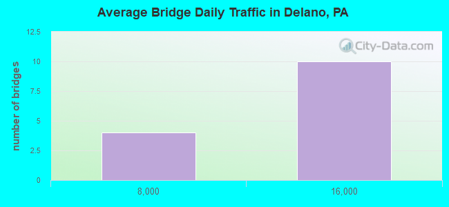
- 134,055Total average daily traffic
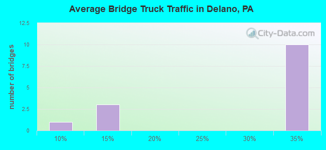
- 42,318Total average daily truck traffic
- National Bridge Inventory (NBI) Registered Bridges for Delano
- No street view available for this location
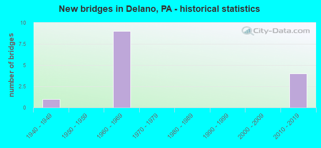
- New bridges - historical statistics
- 11940-1949
- 91960-1969
- 42010-2019
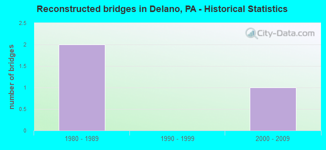
- Reconstructed bridges - Historical Statistics
- 21980-1989
- 01990-1999
- 12000-2009
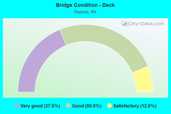
- Bridge Condition - Deck
- 37.5%Very good
- 50.0%Good
- 12.5%Satisfactory
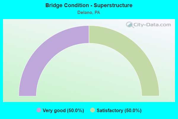
- Bridge Condition - Superstructure
- 50.0%Very good
- 50.0%Satisfactory
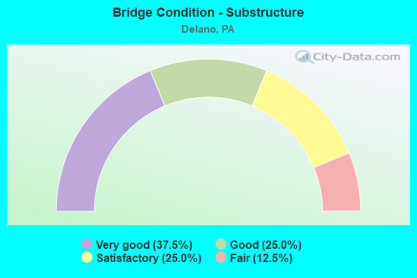
- Bridge Condition - Substructure
- 37.5%Very good
- 25.0%Good
- 25.0%Satisfactory
- 12.5%Fair
Find on map >> Show street view
Structure Number: 30601, Location: EXIT 134 (38) (Lat: 40.835633, Lng: -76.062681), Route carried "on" structure: Interstate 81, Year Built: 1966, Year Reconstructed: 1986, Status: Open, Structure Length: 3.54m (11.61ft), Average Daily Traffic: 12,792 (year 2021), Truck Traffic: 33%, Average Future Daily Traffic: 15,473 (year 2032), Design Load: HL 93, Features Intersected: SR 1017 (LR 53044)
Minimum Vertical Clearance: 30+ m (98+ ft), Kilometerpoint: 59.238, Lanes on structure: 2, Lanes under structure: 2, Base Highway Network: Yes, Owner: State Highway Agency, Approaching Roadway Width: 13.7m (44.9ft), Skew: 12 degrees, Material/Design: Prestressed concrete, Design/Construction: Stringer/Multi-beam, Number Of Spans In Main Unit: 3, Length of Maximum Span: 13.4m (44.0ft), Curb or Sidewalk Widths: Left: 0.2m (0.7ft), Right: 0.2m (0.7ft), Curb-To-Curb Width: 12.8m (42.0ft), Out-to-Out Width: 13.9m (45.6ft)
Condition: Deck: Very good, Superstructure: Satisfactory, Substructure: Satisfactory, Operating Rating: 46.3 metric tons, Method Used To Determine Operating Rating: Load and Resistance Factor (LRFR), Inventory Rating: 26.3 metric tons, Method Used To Determine Inventory Rating: Load and Resistance Factor (LRFR), Structural Evaluation: Equal to present minimum criteria, Deck Geometry: Equal to present desirable criteria, Underclear: Meets minimum limits, Approach Roadway Alignment: Equal to present desirable criteria, Length Of Structure Improvement: 4.40m (14.44ft), Designated Inspection Frequency: Every 24 months, Inspection Date: July 2020, Deck Structure Type: Concrete Cast-file-Place, Wearing Surface/Protective System: Wearing Surface: Latex Concrete, Deck Protection: Epoxy Coated Reinforcing
Find on map >> Show street view
Structure Number: 30602, Location: EXIT 134 (38) DELANO EXIT (Lat: 40.835608, Lng: -76.063064), Route carried "on" structure: Interstate 81, Year Built: 1966, Year Reconstructed: 2014, Status: Open, Structure Length: 3.54m (11.61ft), Average Daily Traffic: 13,423 (year 2021), Truck Traffic: 31%, Average Future Daily Traffic: 15,148 (year 2032), Design Load: HL 93, Features Intersected: SR 1017 (LR 53044)
Minimum Vertical Clearance: 30+ m (98+ ft), Kilometerpoint: 59.151, Lanes on structure: 2, Lanes under structure: 2, Base Highway Network: Yes, Owner: State Highway Agency, Approaching Roadway Width: 12.2m (40.0ft), Skew: 12 degrees, Material/Design: Prestressed concrete, Design/Construction: Stringer/Multi-beam, Number Of Spans In Main Unit: 3, Length of Maximum Span: 13.4m (44.0ft), Curb or Sidewalk Widths: Left: 0.2m (0.7ft), Right: 0.2m (0.7ft), Curb-To-Curb Width: 12.8m (42.0ft), Out-to-Out Width: 13.9m (45.6ft)
Condition: Deck: Good, Superstructure: Satisfactory, Substructure: Good, Operating Rating: 46.3 metric tons, Method Used To Determine Operating Rating: Assigned ratings based on Load and Resistance Factor Design (LRFD) reported in metric tons, Inventory Rating: 26.3 metric tons, Method Used To Determine Inventory Rating: Assigned ratings based on Load and Resistance Factor Design (LRFD) reported in metric tons, Structural Evaluation: Equal to present minimum criteria, Deck Geometry: Equal to present desirable criteria, Underclear: Better than present minimum criteria, Approach Roadway Alignment: Equal to present desirable criteria, Length Of Structure Improvement: 4.40m (14.44ft), Designated Inspection Frequency: Every 24 months, Inspection Date: July 2020, Deck Structure Type: Concrete Cast-file-Place, Wearing Surface/Protective System: Wearing Surface: Latex Concrete, Deck Protection: Epoxy Coated Reinforcing
Find on map >> Show street view
Structure Number: 30761, Location: 2 MI.NORTH OF DELANO (Lat: 40.864278, Lng: -76.039453), Route carried "on" structure: State highway , Year Built: 1966, Year Reconstructed: 1986, Status: Open, Structure Length: 9.17m (30.09ft), Average Daily Traffic: 97 (year 2022), Truck Traffic: 7%, Average Future Daily Traffic: 154 (year 2032), Design Load: HS 20, Features Intersected: I-81 (LR1005), Facility Carried by Structure: SR 1016(LR 53045)
Minimum Vertical Clearance: 30+ m (98+ ft), Kilometerpoint: 3.792, Lanes on structure: 2, Lanes under structure: 8, Owner: State Highway Agency, Approaching Roadway Width: 8.5m (27.9ft), Skew: 3 degrees, Material/Design: Prestressed concrete, Design/Construction: Box Beam or Girders - Single/Spread, Number Of Spans In Main Unit: 5, Length of Maximum Span: 20.1m (65.9ft), Curb-To-Curb Width: 8.8m (28.9ft), Out-to-Out Width: 9.9m (32.5ft)
Condition: Deck: Good, Superstructure: Satisfactory, Substructure: Satisfactory, Operating Rating: 38.1 metric tons, Method Used To Determine Operating Rating: Load Factor (LF), Inventory Rating: 29.0 metric tons, Method Used To Determine Inventory Rating: Load Factor (LF), Structural Evaluation: Equal to present minimum criteria, Deck Geometry: Better than present minimum criteria, Underclear: Somewhat better than minimum adequacy, Approach Roadway Alignment: Equal to present desirable criteria, Length Of Structure Improvement: 10.10m (33.14ft), Designated Inspection Frequency: Every 24 months, Inspection Date: October 2019, Deck Structure Type: Concrete Cast-file-Place, Wearing Surface/Protective System: Wearing Surface: Monolithic Concrete, Deck Protection: Epoxy Coated Reinforcing
Find on map >> Show street view
Structure Number: 30764, Location: EAST END PATCH, DELANO (Lat: 40.835797, Lng: -76.065797), Route carried "on" structure: State highway , Year Built: 1946, Status: Open, Structure Length: 1.40m (4.59ft), Average Daily Traffic: 961 (year 2021), Truck Traffic: 14%, Average Future Daily Traffic: 1,226 (year 2032), Design Load: HS 20, Features Intersected: READING & NORTHERN RR, Facility Carried by Structure: SR 1017
Minimum Vertical Clearance: 30+ m (98+ ft), Kilometerpoint: 2.876, Lanes on structure: 2, Owner: Railroad, Approaching Roadway Width: 6.4m (21.0ft), Skew: 1 degrees, Material/Design: Concrete, Design/Construction: Tee Beam, Number Of Spans In Main Unit: 1, Length of Maximum Span: 13.4m (44.0ft), Curb-To-Curb Width: 7.3m (24.0ft), Out-to-Out Width: 8.4m (27.6ft)
Condition: Deck: Satisfactory, Superstructure: Satisfactory, Substructure: Fair, Operating Rating: 57.2 metric tons, Method Used To Determine Operating Rating: Load Factor (LF), Inventory Rating: 34.5 metric tons, Method Used To Determine Inventory Rating: Load Factor (LF), Structural Evaluation: Somewhat better than minimum adequacy, Deck Geometry: Meets minimum limits, Underclear: High priority of corrective action, Approach Roadway Alignment: Equal to present desirable criteria, Length Of Structure Improvement: 2.00m (6.56ft), Designated Inspection Frequency: Every 24 months, Inspection Date: Febuary 2021, Bridge Improvement Cost: $7,000, Roadway Improvement Cost: $20,000, Total Project Cost: $92,000, Deck Structure Type: Concrete Cast-file-Place, Wearing Surface/Protective System: Wearing Surface: Bituminous
Find on map >> Show street view
Structure Number: 48276, Location: 2.7MI. N. OF EXIT134 (38) (Lat: 40.867844, Lng: -76.036469), Route carried "on" structure: Interstate 81, Year Built: 2013, Status: Open, Structure Length: 3.14m (10.30ft), Average Daily Traffic: 13,423 (year 2021), Truck Traffic: 31%, Average Future Daily Traffic: 15,056 (year 2038), Design Load: HL 93, Features Intersected: RBMNRR
Minimum Vertical Clearance: 30.18m (99.02ft), Kilometerpoint: 63.975, Lanes on structure: 2, Base Highway Network: Yes, Owner: State Highway Agency, Approaching Roadway Width: 13.1m (43.0ft), Skew: 5 degrees, Material/Design: Prestressed concrete, Design/Construction: Stringer/Multi-beam, Number Of Spans In Main Unit: 1, Length of Maximum Span: 31.4m (103.0ft), Curb or Sidewalk Widths: Left: 0.2m (0.7ft), Right: 0.2m (0.7ft), Curb-To-Curb Width: 12.2m (40.0ft), Out-to-Out Width: 13.2m (43.3ft)
Condition: Deck: Good, Superstructure: Very good, Substructure: Very good, Operating Rating: 71.0 metric tons, Method Used To Determine Operating Rating: Assigned ratings based on Load and Resistance Factor Design (LRFD) reported by rating factor (RF) using HL93 loadings, Inventory Rating: 38.6 metric tons, Method Used To Determine Inventory Rating: Assigned ratings based on Load and Resistance Factor Design (LRFD) reported by rating factor (RF) using HL93 loadings, Structural Evaluation: Equal to present desirable criteria, Deck Geometry: Better than present minimum criteria, Underclear: High priority of corrective action, Approach Roadway Alignment: Equal to present desirable criteria, Designated Inspection Frequency: Every 48 months, Inspection Date: December 2019, Deck Structure Type: Concrete Cast-file-Place, Wearing Surface/Protective System: Wearing Surface: Monolithic Concrete, Deck Protection: Epoxy Coated Reinforcing
Find on map >> Show street view
Structure Number: 48277, Location: 0.4MI.N. OF EXIT 134 (38) (Lat: 40.841153, Lng: -76.059742), Route carried "on" structure: Interstate 81, Year Built: 2013, Status: Open, Structure Length: 7.56m (24.80ft), Average Daily Traffic: 13,423 (year 2021), Truck Traffic: 31%, Average Future Daily Traffic: 18,333 (year 2037), Design Load: HL 93, Features Intersected: READING/NORTHERN RR
Minimum Vertical Clearance: 30.18m (99.02ft), Kilometerpoint: 59.938, Lanes on structure: 2, Base Highway Network: Yes, Owner: State Highway Agency, Approaching Roadway Width: 13.1m (43.0ft), Skew: 3 degrees, Material/Design: Prestressed concrete, Design/Construction: Stringer/Multi-beam, Number Of Spans In Main Unit: 3, Length of Maximum Span: 26.8m (87.9ft), Curb or Sidewalk Widths: Left: 0.2m (0.7ft), Right: 0.2m (0.7ft), Curb-To-Curb Width: 12.2m (40.0ft), Out-to-Out Width: 13.2m (43.3ft)
Condition: Deck: Good, Superstructure: Very good, Substructure: Good, Operating Rating: 60.6 metric tons, Method Used To Determine Operating Rating: Assigned ratings based on Load and Resistance Factor Design (LRFD) reported by rating factor (RF) using HL93 loadings, Inventory Rating: 37.3 metric tons, Method Used To Determine Inventory Rating: Assigned ratings based on Load and Resistance Factor Design (LRFD) reported by rating factor (RF) using HL93 loadings, Structural Evaluation: Better than present minimum criteria, Deck Geometry: Better than present minimum criteria, Underclear: High priority of corrective action, Approach Roadway Alignment: Equal to present desirable criteria, Designated Inspection Frequency: Every 48 months, Inspection Date: October 2019, Deck Structure Type: Concrete Cast-file-Place, Wearing Surface/Protective System: Wearing Surface: Monolithic Concrete, Deck Protection: Epoxy Coated Reinforcing
Find on map >> Show street view
Structure Number: 48917, Location: 2.7MI.N.OF EXIT 134 (38) (Lat: 40.867431, Lng: -76.036578), Route carried "on" structure: Interstate 81, Year Built: 2014, Status: Open, Structure Length: 2.71m (8.89ft), Average Daily Traffic: 12,792 (year 2021), Truck Traffic: 33%, Average Future Daily Traffic: 17,382 (year 2038), Design Load: HL 93, Features Intersected: READING/NORTHERN RR
Minimum Vertical Clearance: 30+ m (98+ ft), Kilometerpoint: 63.260, Lanes on structure: 2, Base Highway Network: Yes, Owner: State Highway Agency, Approaching Roadway Width: 13.1m (43.0ft), Skew: 4 degrees, Material/Design: Prestressed concrete, Design/Construction: Stringer/Multi-beam, Number Of Spans In Main Unit: 1, Length of Maximum Span: 26.5m (86.9ft), Curb or Sidewalk Widths: Left: 0.2m (0.7ft), Right: 0.2m (0.7ft), Curb-To-Curb Width: 12.2m (40.0ft), Out-to-Out Width: 13.2m (43.3ft)
Condition: Deck: Very good, Superstructure: Very good, Substructure: Very good, Operating Rating: 72.6 metric tons, Method Used To Determine Operating Rating: Assigned ratings based on Load and Resistance Factor Design (LRFD) reported by rating factor (RF) using HL93 loadings, Inventory Rating: 38.6 metric tons, Method Used To Determine Inventory Rating: Assigned ratings based on Load and Resistance Factor Design (LRFD) reported by rating factor (RF) using HL93 loadings, Structural Evaluation: Equal to present desirable criteria, Deck Geometry: Better than present minimum criteria, Underclear: High priority of corrective action, Approach Roadway Alignment: Equal to present desirable criteria, Designated Inspection Frequency: Every 48 months, Inspection Date: September 2018, Deck Structure Type: Concrete Cast-file-Place, Wearing Surface/Protective System: Wearing Surface: Monolithic Concrete, Deck Protection: Epoxy Coated Reinforcing
Find on map >> Show street view
Structure Number: 48918, Location: 0.4MI.N.OF EXIT 134(38) (Lat: 40.841181, Lng: -76.059292), Route carried "on" structure: Interstate 81, Year Built: 2014, Status: Open, Structure Length: 6.43m (21.10ft), Average Daily Traffic: 12,792 (year 2021), Truck Traffic: 33%, Average Future Daily Traffic: 17,382 (year 2038), Design Load: HL 93, Features Intersected: READING/NORTHERN RR
Minimum Vertical Clearance: 30.18m (99.02ft), Kilometerpoint: 60.045, Lanes on structure: 2, Base Highway Network: Yes, Owner: State Highway Agency, Approaching Roadway Width: 13.1m (43.0ft), Skew: 2 degrees, Material/Design: Prestressed concrete continuous, Design/Construction: Stringer/Multi-beam, Number Of Spans In Main Unit: 3, Length of Maximum Span: 27.1m (88.9ft), Curb or Sidewalk Widths: Left: 0.2m (0.7ft), Right: 0.2m (0.7ft), Curb-To-Curb Width: 12.2m (40.0ft), Out-to-Out Width: 13.2m (43.3ft)
Condition: Deck: Very good, Superstructure: Very good, Substructure: Very good, Operating Rating: 56.1 metric tons, Method Used To Determine Operating Rating: Assigned ratings based on Load and Resistance Factor Design (LRFD) reported by rating factor (RF) using HL93 loadings, Inventory Rating: 38.9 metric tons, Method Used To Determine Inventory Rating: Assigned ratings based on Load and Resistance Factor Design (LRFD) reported by rating factor (RF) using HL93 loadings, Structural Evaluation: Equal to present desirable criteria, Deck Geometry: Better than present minimum criteria, Underclear: High priority of corrective action, Approach Roadway Alignment: Equal to present desirable criteria, Designated Inspection Frequency: Every 48 months, Inspection Date: September 2018, Deck Structure Type: Concrete Cast-file-Place, Wearing Surface/Protective System: Wearing Surface: Monolithic Concrete, Deck Protection: Epoxy Coated Reinforcing
Find on map >> Show street view
Structure Number: 30601, Location: EXIT 134 (38) (Lat: 40.835633, Lng: -76.062681), Route carried "under" structure: State highway , Year Built: 1966, Structure Length: 0. m, Average Daily Traffic: 961 (year 2021), Truck Traffic: 14%, Features Intersected: SR 1017 (LR 53044), Facility Carried by Structure: I-81 NB (LR1005)
Minimum Vertical Clearance: 4.54m (14.90ft), Kilometerpoint: 2.876, Lanes on structure: 2, Lanes under structure: 2, Material/Design: Prestressed concrete, Design/Construction: Stringer/Multi-beam, Length of Maximum Span: 13.4m (44.0ft)
Find on map >> Show street view
Structure Number: 30602, Location: EXIT 134 (38) DELANO EXIT (Lat: 40.835608, Lng: -76.063064), Route carried "under" structure: State highway , Year Built: 1966, Structure Length: 0. m, Average Daily Traffic: 961 (year 2021), Truck Traffic: 14%, Features Intersected: SR 1017 (LR 53044), Facility Carried by Structure: I-81SB (LR 1005)
Minimum Vertical Clearance: 4.85m (15.91ft), Kilometerpoint: 2.876, Lanes on structure: 2, Lanes under structure: 2, Material/Design: Prestressed concrete, Design/Construction: Stringer/Multi-beam, Length of Maximum Span: 13.4m (44.0ft)
Find on map >> Show street view
Structure Number: 30754, Location: 1 MI.NORTH OF DELANO (Lat: 40.845992, Lng: -76.056594), Route carried "under" structure: Interstate 81, Year Built: 1966, Structure Length: 0. m, Average Daily Traffic: 13,423 (year 2021), Truck Traffic: 31%, Features Intersected: I-81 (LR1005), Facility Carried by Structure: SR 1012 (LR 53041)
Minimum Vertical Clearance: 6.07m (19.91ft), Kilometerpoint: 60.743, Lanes on structure: 2, Lanes under structure: 4, Material/Design: Steel continuous, Design/Construction: Stringer/Multi-beam, Length of Maximum Span: 33.5m (109.9ft)
Find on map >> Show street view
Structure Number: 30754, Location: 1 MI.NORTH OF DELANO (Lat: 40.845992, Lng: -76.056594), Route carried "under" structure: Interstate 81, Year Built: 1966, Structure Length: 0. m, Average Daily Traffic: 12,792 (year 2021), Truck Traffic: 33%, Features Intersected: I-81 (LR1005), Facility Carried by Structure: SR 1012 (LR 53041)
Minimum Vertical Clearance: 5.61m (18.41ft), Kilometerpoint: 60.836, Lanes on structure: 2, Lanes under structure: 4, Material/Design: Steel continuous, Design/Construction: Stringer/Multi-beam, Length of Maximum Span: 33.5m (109.9ft)
Find on map >> Show street view
Structure Number: 30761, Location: 2 MI.NORTH OF DELANO (Lat: 40.864278, Lng: -76.039453), Route carried "under" structure: Interstate 81, Year Built: 1966, Structure Length: 0. m, Average Daily Traffic: 12,792 (year 2021), Truck Traffic: 33%, Features Intersected: I-81 (LR1005), Facility Carried by Structure: SR 1016(LR 53045)
Minimum Vertical Clearance: 7.53m (24.70ft), Kilometerpoint: 63.260, Lanes on structure: 2, Lanes under structure: 4, Material/Design: Prestressed concrete, Design/Construction: Box Beam or Girders - Single/Spread, Length of Maximum Span: 20.1m (65.9ft)
Find on map >> Show street view
Structure Number: 30761, Location: 2 MI.NORTH OF DELANO (Lat: 40.864278, Lng: -76.039453), Route carried "under" structure: Interstate 81, Year Built: 1966, Structure Length: 0. m, Average Daily Traffic: 13,423 (year 2021), Truck Traffic: 31%, Features Intersected: I-81 (LR1005), Facility Carried by Structure: SR 1016(LR 53045)
Minimum Vertical Clearance: 4.91m (16.11ft), Kilometerpoint: 63.168, Lanes on structure: 2, Lanes under structure: 4, Material/Design: Prestressed concrete, Design/Construction: Box Beam or Girders - Single/Spread, Length of Maximum Span: 20.1m (65.9ft)