Bridge Statistics for Delavan, Wisconsin (WI)
Condition, Traffic, Stress, Structural Evaluation, Project Costs
- National Bridge Inventory (NBI) Statistics
- 37Number of bridges
- 335ft / 102mTotal length
- $530,000Total costs
- 312,750Total average daily traffic
- 35,856Total average daily truck traffic
- National Bridge Inventory (NBI) Registered Bridges for Delavan
- No street view available for this location
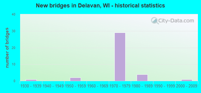
- New bridges - historical statistics
- 11930-1939
- 21950-1959
- 291970-1979
- 41980-1989
- 12000-2009

- Reconstructed bridges - Historical Statistics
- 12000-2009
- 22010-2019
- 12020-2022


- Bridge Condition - Deck
- 4.8%Excellent
- 47.6%Good
- 38.1%Satisfactory
- 9.5%Fair

- Bridge Condition - Superstructure
- 47.6%Good
- 42.9%Satisfactory
- 4.8%Fair
- 4.8%Poor

- Bridge Condition - Substructure
- 4.8%Very good
- 47.6%Good
- 33.3%Satisfactory
- 14.3%Fair

- Bridge Condition - Channel
- 40.0%Very good
- 40.0%Good
- 20.0%Satisfactory
Find on map >> Show street view
Structure Number: B640015, Location: 1.8M N JCT CTH M (Lat: 42.668239, Lng: -88.659031), Route carried "on" structure: County highway , Year Built: 1957, Status: Open, Structure Length: 1.03m (3.38ft), Average Daily Traffic: 1,300 (year 2018), Average Future Daily Traffic: 1,306 (year 2039), Design Load: H 15, Features Intersected: TURTLE CREEK, Facility Carried by Structure: CTH P
Minimum Vertical Clearance: 30+ m (98+ ft), Kilometerpoint: 0.000, Lanes on structure: 2, Owner: County Highway Agency, Approaching Roadway Width: 9.8m (32.2ft), Skew: 1 degrees, Material/Design: Concrete, Design/Construction: Slab, Number Of Spans In Main Unit: 1, Length of Maximum Span: 9.4m (30.8ft), Curb-To-Curb Width: 9.1m (29.9ft), Out-to-Out Width: 10.5m (34.4ft)
Condition: Deck: Good, Superstructure: Good, Substructure: Fair, Channel: Very good, Operating Rating: 33.0 metric tons, Method Used To Determine Operating Rating: Load Factor (LF), Inventory Rating: 19.4 metric tons, Method Used To Determine Inventory Rating: Load Factor (LF), Structural Evaluation: Somewhat better than minimum adequacy, Deck Geometry: Somewhat better than minimum adequacy, Waterway Adequacy: Equal to present desirable criteria, Approach Roadway Alignment: Equal to present desirable criteria, Designated Inspection Frequency: Every 24 months, Inspection Date: August 2020, Deck Structure Type: Concrete Cast-file-Place, Wearing Surface/Protective System: Wearing Surface: Bituminous, Membrane: Other
Find on map >> Show street view
Structure Number: B640071, Location: 1.9 MI E JCT IH-43 (Lat: 42.621161, Lng: -88.582686), Route carried "on" structure: State highway 50, Year Built: 1987, Status: Open, Structure Length: 2.18m (7.15ft), Average Daily Traffic: 12,600 (year 2019), Truck Traffic: 8%, Average Future Daily Traffic: 18,660 (year 2040), Design Load: HS 20, Features Intersected: JACKSON CREEK
Minimum Vertical Clearance: 30+ m (98+ ft), Kilometerpoint: 0.000, Lanes on structure: 2, Base Highway Network: Yes, Owner: State Highway Agency, Approaching Roadway Width: 12.8m (42.0ft), Material/Design: Steel, Design/Construction: Stringer/Multi-beam, Number Of Spans In Main Unit: 1, Length of Maximum Span: 20.7m (67.9ft), Curb-To-Curb Width: 15.8m (51.8ft), Out-to-Out Width: 16.8m (55.1ft)
Condition: Deck: Good, Superstructure: Satisfactory, Substructure: Good, Channel: Very good, Operating Rating: 60.4 metric tons, Method Used To Determine Operating Rating: Load Factor (LF), Inventory Rating: 35.6 metric tons, Method Used To Determine Inventory Rating: Load Factor (LF), Structural Evaluation: Equal to present minimum criteria, Deck Geometry: Superior to present desirable criteria, Waterway Adequacy: Equal to present desirable criteria, Approach Roadway Alignment: Equal to present desirable criteria, Designated Inspection Frequency: Every 24 months, Inspection Date: August 2021, Deck Structure Type: Concrete Cast-file-Place, Wearing Surface/Protective System: Wearing Surface: Low Slump Concrete, Deck Protection: Epoxy Coated Reinforcing
Find on map >> Show street view
Structure Number: B640114, Location: 1.9 MI N JCT STH 50 (Lat: 42.644361, Lng: -88.590597), Route carried "on" structure: Interstate 43, Year Built: 1975, Status: Open, Structure Length: 4.75m (15.58ft), Average Daily Traffic: 11,350 (year 2018), Truck Traffic: 16%, Average Future Daily Traffic: 13,620 (year 2038), Design Load: HS 20, Features Intersected: CTH F
Minimum Vertical Clearance: 30+ m (98+ ft), Kilometerpoint: 0.000, Lanes on structure: 2, Lanes under structure: 2, Base Highway Network: Yes, Owner: State Highway Agency, Approaching Roadway Width: 12.2m (40.0ft), Material/Design: Prestressed concrete continuous, Design/Construction: Stringer/Multi-beam, Number Of Spans In Main Unit: 3, Length of Maximum Span: 26.7m (87.6ft), Curb-To-Curb Width: 12.2m (40.0ft), Out-to-Out Width: 13.4m (44.0ft)
Condition: Deck: Satisfactory, Superstructure: Satisfactory, Substructure: Fair, Operating Rating: 91.4 metric tons, Method Used To Determine Operating Rating: Load Factor (LF), Inventory Rating: 38.9 metric tons, Method Used To Determine Inventory Rating: Load Factor (LF), Structural Evaluation: Somewhat better than minimum adequacy, Deck Geometry: Better than present minimum criteria, Underclear: Equal to present minimum criteria, Approach Roadway Alignment: Equal to present desirable criteria, Designated Inspection Frequency: Every 24 months, Inspection Date: September 2021, Deck Structure Type: Concrete Cast-file-Place, Wearing Surface/Protective System: Wearing Surface: Low Slump Concrete
Find on map >> Show street view
Structure Number: B640115, Location: 2.7 MI S JCT STH 67 (Lat: 42.644789, Lng: -88.590022), Route carried "on" structure: Interstate 43, Year Built: 1975, Status: Open, Structure Length: 4.75m (15.58ft), Average Daily Traffic: 11,350 (year 2018), Truck Traffic: 16%, Average Future Daily Traffic: 13,620 (year 2038), Design Load: HS 20, Features Intersected: CTH F
Minimum Vertical Clearance: 30+ m (98+ ft), Kilometerpoint: 0.000, Lanes on structure: 2, Lanes under structure: 2, Base Highway Network: Yes, Owner: State Highway Agency, Approaching Roadway Width: 12.2m (40.0ft), Material/Design: Prestressed concrete continuous, Design/Construction: Stringer/Multi-beam, Number Of Spans In Main Unit: 3, Length of Maximum Span: 26.7m (87.6ft), Curb-To-Curb Width: 12.2m (40.0ft), Out-to-Out Width: 13.4m (44.0ft)
Condition: Deck: Satisfactory, Superstructure: Good, Substructure: Fair, Operating Rating: 91.4 metric tons, Method Used To Determine Operating Rating: Load Factor (LF), Inventory Rating: 38.9 metric tons, Method Used To Determine Inventory Rating: Load Factor (LF), Structural Evaluation: Somewhat better than minimum adequacy, Deck Geometry: Better than present minimum criteria, Underclear: Equal to present minimum criteria, Approach Roadway Alignment: Equal to present desirable criteria, Designated Inspection Frequency: Every 24 months, Inspection Date: September 2021, Deck Structure Type: Concrete Cast-file-Place, Wearing Surface/Protective System: Wearing Surface: Low Slump Concrete
Find on map >> Show street view
Structure Number: B640116, Location: 1.0 MI N JCT STH 50 (Lat: 42.640089, Lng: -88.605361), Route carried "on" structure: Interstate 43, Year Built: 1975, Status: Open, Structure Length: 7.16m (23.49ft), Average Daily Traffic: 10,350 (year 2018), Truck Traffic: 12%, Average Future Daily Traffic: 13,620 (year 2038), Design Load: HS 20, Features Intersected: LRD MOUND RD
Minimum Vertical Clearance: 30+ m (98+ ft), Kilometerpoint: 0.000, Lanes on structure: 2, Lanes under structure: 2, Base Highway Network: Yes, Owner: State Highway Agency, Approaching Roadway Width: 12.2m (40.0ft), Skew: 4 degrees, Material/Design: Steel continuous, Design/Construction: Stringer/Multi-beam, Number Of Spans In Main Unit: 3, Length of Maximum Span: 39.5m (129.6ft), Curb-To-Curb Width: 12.2m (40.0ft), Out-to-Out Width: 13.4m (44.0ft)
Condition: Deck: Satisfactory, Superstructure: Satisfactory, Substructure: Satisfactory, Operating Rating: 53.9 metric tons, Method Used To Determine Operating Rating: Load Factor (LF), Inventory Rating: 32.4 metric tons, Method Used To Determine Inventory Rating: Load Factor (LF), Structural Evaluation: Equal to present minimum criteria, Deck Geometry: Better than present minimum criteria, Underclear: Equal to present minimum criteria, Approach Roadway Alignment: Equal to present desirable criteria, Designated Inspection Frequency: Every 24 months, Inspection Date: September 2021, Deck Structure Type: Concrete Cast-file-Place, Wearing Surface/Protective System: Wearing Surface: Epoxy Overlay
Find on map >> Show street view
Structure Number: B640117, Location: 3.6 MI S JCT STH 67 (Lat: 42.640531, Lng: -88.605556), Route carried "on" structure: Interstate 43, Year Built: 1975, Status: Open, Structure Length: 7.17m (23.52ft), Average Daily Traffic: 11,350 (year 2018), Truck Traffic: 12%, Average Future Daily Traffic: 13,620 (year 2038), Design Load: HS 20, Features Intersected: LRD MOUND RD
Minimum Vertical Clearance: 30+ m (98+ ft), Kilometerpoint: 0.000, Lanes on structure: 2, Lanes under structure: 2, Base Highway Network: Yes, Owner: State Highway Agency, Approaching Roadway Width: 12.2m (40.0ft), Skew: 4 degrees, Material/Design: Steel continuous, Design/Construction: Stringer/Multi-beam, Number Of Spans In Main Unit: 3, Length of Maximum Span: 38.9m (127.6ft), Curb-To-Curb Width: 12.2m (40.0ft), Out-to-Out Width: 13.4m (44.0ft)
Condition: Deck: Fair, Superstructure: Satisfactory, Substructure: Good, Operating Rating: 55.5 metric tons, Method Used To Determine Operating Rating: Load Factor (LF), Inventory Rating: 32.4 metric tons, Method Used To Determine Inventory Rating: Load Factor (LF), Structural Evaluation: Equal to present minimum criteria, Deck Geometry: Better than present minimum criteria, Underclear: Better than present minimum criteria, Approach Roadway Alignment: Equal to present desirable criteria, Designated Inspection Frequency: Every 24 months, Inspection Date: September 2021, Deck Structure Type: Concrete Cast-file-Place, Wearing Surface/Protective System: Wearing Surface: Epoxy Overlay
Find on map >> Show street view
Structure Number: B640118, Location: 6.4 MI N JCT USH 14 (Lat: 42.627425, Lng: -88.618683), Route carried "on" structure: Interstate 43, Year Built: 1975, Status: Open, Structure Length: 7.35m (24.11ft), Average Daily Traffic: 11,350 (year 2018), Truck Traffic: 16%, Average Future Daily Traffic: 13,620 (year 2038), Design Load: HS 20, Features Intersected: STH 50
Minimum Vertical Clearance: 30+ m (98+ ft), Kilometerpoint: 0.000, Lanes on structure: 2, Lanes under structure: 4, Base Highway Network: Yes, Owner: State Highway Agency, Approaching Roadway Width: 12.2m (40.0ft), Skew: 4 degrees, Material/Design: Steel continuous, Design/Construction: Stringer/Multi-beam, Number Of Spans In Main Unit: 2, Length of Maximum Span: 36.6m (120.1ft), Curb-To-Curb Width: 12.2m (40.0ft), Out-to-Out Width: 13.4m (44.0ft)
Condition: Deck: Satisfactory, Superstructure: Satisfactory, Substructure: Satisfactory, Operating Rating: 55.5 metric tons, Method Used To Determine Operating Rating: Load Factor (LF), Inventory Rating: 32.4 metric tons, Method Used To Determine Inventory Rating: Load Factor (LF), Structural Evaluation: Equal to present minimum criteria, Deck Geometry: Better than present minimum criteria, Underclear: Equal to present minimum criteria, Approach Roadway Alignment: Equal to present desirable criteria, Designated Inspection Frequency: Every 24 months, Inspection Date: August 2021, Deck Structure Type: Concrete Cast-file-Place, Wearing Surface/Protective System: Wearing Surface: Low Slump Concrete
Find on map >> Show street view
Structure Number: B640119, Location: 4.6 MI S JCT STH 67 (Lat: 42.627911, Lng: -88.618858), Route carried "on" structure: Interstate 43, Year Built: 1975, Status: Open, Structure Length: 7.35m (24.11ft), Average Daily Traffic: 9,000 (year 2020), Truck Traffic: 16%, Average Future Daily Traffic: 13,620 (year 2038), Design Load: HS 20, Features Intersected: STH 50
Minimum Vertical Clearance: 30+ m (98+ ft), Kilometerpoint: 0.000, Lanes on structure: 2, Lanes under structure: 4, Base Highway Network: Yes, Owner: State Highway Agency, Approaching Roadway Width: 12.2m (40.0ft), Skew: 4 degrees, Material/Design: Steel continuous, Design/Construction: Stringer/Multi-beam, Number Of Spans In Main Unit: 2, Length of Maximum Span: 36.6m (120.1ft), Curb-To-Curb Width: 12.2m (40.0ft), Out-to-Out Width: 13.4m (44.0ft)
Condition: Deck: Good, Superstructure: Good, Substructure: Good, Operating Rating: 53.9 metric tons, Method Used To Determine Operating Rating: Load Factor (LF), Inventory Rating: 32.4 metric tons, Method Used To Determine Inventory Rating: Load Factor (LF), Structural Evaluation: Better than present minimum criteria, Deck Geometry: Better than present minimum criteria, Underclear: Equal to present minimum criteria, Approach Roadway Alignment: Equal to present desirable criteria, Designated Inspection Frequency: Every 24 months, Inspection Date: August 2021, Deck Structure Type: Concrete Cast-file-Place, Wearing Surface/Protective System: Wearing Surface: Low Slump Concrete
Find on map >> Show street view
Structure Number: B640121, Location: 1.4 M S JCT STH 11 (Lat: 42.612031, Lng: -88.649239), Route carried "on" structure: County highway , Year Built: 1976, Year Reconstructed: 2009, Status: Open, Structure Length: 7.46m (24.48ft), Average Daily Traffic: 3,000 (year 2018), Average Future Daily Traffic: 3,600 (year 2038), Design Load: HS 20, Features Intersected: IH 43, Facility Carried by Structure: CTH O
Minimum Vertical Clearance: 30+ m (98+ ft), Kilometerpoint: 0.000, Lanes on structure: 2, Lanes under structure: 4, Owner: State Highway Agency, Approaching Roadway Width: 9.8m (32.2ft), Skew: 1 degrees, Material/Design: Steel continuous, Design/Construction: Stringer/Multi-beam, Number Of Spans In Main Unit: 2, Length of Maximum Span: 37.3m (122.4ft), Curb-To-Curb Width: 13.4m (44.0ft), Out-to-Out Width: 14.6m (47.9ft)
Condition: Deck: Good, Superstructure: Good, Substructure: Satisfactory, Operating Rating: 63.7 metric tons, Method Used To Determine Operating Rating: Load Factor (LF), Inventory Rating: 37.3 metric tons, Method Used To Determine Inventory Rating: Load Factor (LF), Structural Evaluation: Equal to present minimum criteria, Deck Geometry: Better than present minimum criteria, Underclear: Somewhat better than minimum adequacy, Approach Roadway Alignment: Equal to present desirable criteria, Designated Inspection Frequency: Every 24 months, Inspection Date: August 2021, Deck Structure Type: Concrete Cast-file-Place, Wearing Surface/Protective System: Wearing Surface: Monolithic Concrete
Find on map >> Show street view
Structure Number: B640122, Location: 3.2 MI N JCT USH 14 (Lat: 42.618564, Lng: -88.664039), Route carried "on" structure: Interstate 43, Year Built: 1975, Year Reconstructed: 2015, Status: Open, Structure Length: 4.52m (14.83ft), Average Daily Traffic: 11,350 (year 2018), Truck Traffic: 12%, Average Future Daily Traffic: 18,200 (year 2039), Design Load: HS 20, Features Intersected: LRD ELM RIDGE RD
Minimum Vertical Clearance: 30+ m (98+ ft), Kilometerpoint: 0.000, Lanes on structure: 2, Lanes under structure: 2, Base Highway Network: Yes, Owner: State Highway Agency, Approaching Roadway Width: 12.2m (40.0ft), Skew: 3 degrees, Material/Design: Prestressed concrete continuous, Design/Construction: Stringer/Multi-beam, Number Of Spans In Main Unit: 3, Length of Maximum Span: 19.5m (64.0ft), Curb-To-Curb Width: 12.2m (40.0ft), Out-to-Out Width: 13.1m (43.0ft)
Condition: Deck: Good, Superstructure: Satisfactory, Substructure: Satisfactory, Operating Rating: 37.6 metric tons, Method Used To Determine Operating Rating: Load Factor (LF), Inventory Rating: 32.4 metric tons, Method Used To Determine Inventory Rating: Load Factor (LF), Structural Evaluation: Equal to present minimum criteria, Deck Geometry: Better than present minimum criteria, Underclear: Equal to present minimum criteria, Approach Roadway Alignment: Equal to present desirable criteria, Designated Inspection Frequency: Every 24 months, Inspection Date: October 2021, Deck Structure Type: Concrete Cast-file-Place, Wearing Surface/Protective System: Wearing Surface: Epoxy Overlay
Find on map >> Show street view
Structure Number: B640123, Location: 2.8 MI S JCT STH 50 (Lat: 42.618847, Lng: -88.663597), Route carried "on" structure: Interstate 43, Year Built: 1975, Year Reconstructed: 2016, Status: Open, Structure Length: 4.47m (14.67ft), Average Daily Traffic: 10,250 (year 2018), Truck Traffic: 12%, Average Future Daily Traffic: 18,200 (year 2039), Design Load: HS 20, Features Intersected: LRD ELM RIDGE RD
Minimum Vertical Clearance: 30+ m (98+ ft), Kilometerpoint: 0.000, Lanes on structure: 2, Lanes under structure: 2, Base Highway Network: Yes, Owner: State Highway Agency, Approaching Roadway Width: 12.2m (40.0ft), Skew: 3 degrees, Material/Design: Prestressed concrete continuous, Design/Construction: Stringer/Multi-beam, Number Of Spans In Main Unit: 3, Length of Maximum Span: 19.5m (64.0ft), Curb-To-Curb Width: 12.2m (40.0ft), Out-to-Out Width: 13.0m (42.7ft)
Condition: Deck: Good, Superstructure: Good, Substructure: Good, Operating Rating: 42.5 metric tons, Method Used To Determine Operating Rating: Load Factor (LF), Inventory Rating: 32.4 metric tons, Method Used To Determine Inventory Rating: Load Factor (LF), Structural Evaluation: Better than present minimum criteria, Deck Geometry: Better than present minimum criteria, Underclear: Equal to present minimum criteria, Approach Roadway Alignment: Equal to present desirable criteria, Designated Inspection Frequency: Every 38 months, Inspection Date: August 2020, Deck Structure Type: Concrete Cast-file-Place, Wearing Surface/Protective System: Wearing Surface: Epoxy Overlay
Find on map >> Show street view
Structure Number: B640124, Location: 0.2 MI N JCT CTH X (Lat: 42.619394, Lng: -88.665750), Route carried "on" structure: Interstate 43, Year Built: 1975, Status: Open, Structure Length: 4.74m (15.55ft), Average Daily Traffic: 11,350 (year 2018), Truck Traffic: 12%, Average Future Daily Traffic: 13,620 (year 2038), Design Load: HS 20, Features Intersected: CMSTPP RR
Minimum Vertical Clearance: 30+ m (98+ ft), Kilometerpoint: 0.000, Lanes on structure: 2, Base Highway Network: Yes, Owner: State Highway Agency, Approaching Roadway Width: 12.2m (40.0ft), Skew: 2 degrees, Material/Design: Prestressed concrete continuous, Design/Construction: Stringer/Multi-beam, Number Of Spans In Main Unit: 3, Length of Maximum Span: 16.0m (52.5ft), Curb-To-Curb Width: 12.2m (40.0ft), Out-to-Out Width: 13.4m (44.0ft)
Condition: Deck: Good, Superstructure: Good, Substructure: Good, Operating Rating: 39.2 metric tons, Method Used To Determine Operating Rating: Load Factor (LF), Inventory Rating: 22.7 metric tons, Method Used To Determine Inventory Rating: Load Factor (LF), Structural Evaluation: Somewhat better than minimum adequacy, Deck Geometry: Better than present minimum criteria, Underclear: Superior to present desirable criteria, Approach Roadway Alignment: Equal to present desirable criteria, Designated Inspection Frequency: Every 24 months, Inspection Date: July 2021, Deck Structure Type: Concrete Cast-file-Place, Wearing Surface/Protective System: Wearing Surface: Epoxy Overlay
Find on map >> Show street view
Structure Number: B640125, Location: 2.9 MI S JCT STH 50 (Lat: 42.619386, Lng: -88.664706), Route carried "on" structure: Interstate 43, Year Built: 1975, Status: Open, Structure Length: 4.74m (15.55ft), Average Daily Traffic: 11,350 (year 2018), Truck Traffic: 12%, Average Future Daily Traffic: 13,620 (year 2038), Design Load: HS 20, Features Intersected: CMSTPP RR
Minimum Vertical Clearance: 30+ m (98+ ft), Kilometerpoint: 0.000, Lanes on structure: 2, Base Highway Network: Yes, Owner: State Highway Agency, Approaching Roadway Width: 12.2m (40.0ft), Skew: 2 degrees, Material/Design: Prestressed concrete continuous, Design/Construction: Stringer/Multi-beam, Number Of Spans In Main Unit: 3, Length of Maximum Span: 16.0m (52.5ft), Curb-To-Curb Width: 12.2m (40.0ft), Out-to-Out Width: 13.4m (44.0ft)
Condition: Deck: Satisfactory, Superstructure: Good, Substructure: Good, Operating Rating: 39.2 metric tons, Method Used To Determine Operating Rating: Load Factor (LF), Inventory Rating: 24.3 metric tons, Method Used To Determine Inventory Rating: Load Factor (LF), Structural Evaluation: Equal to present minimum criteria, Deck Geometry: Better than present minimum criteria, Underclear: Superior to present desirable criteria, Approach Roadway Alignment: Equal to present desirable criteria, Designated Inspection Frequency: Every 24 months, Inspection Date: July 2021, Deck Structure Type: Concrete Cast-file-Place, Wearing Surface/Protective System: Wearing Surface: Low Slump Concrete
Find on map >> Show street view
Structure Number: B640126, Location: 2.9 MI N JCT USH 14 (Lat: 42.620633, Lng: -88.670128), Route carried "on" structure: Interstate 43, Year Built: 1975, Year Reconstructed: 2020, Status: Open, Structure Length: 7.74m (25.39ft), Average Daily Traffic: 11,350 (year 2018), Truck Traffic: 17%, Average Future Daily Traffic: 13,620 (year 2038), Design Load: HS 20, Features Intersected: CTH X - BELOIT RD
Minimum Vertical Clearance: 30+ m (98+ ft), Kilometerpoint: 0.000, Lanes on structure: 3, Lanes under structure: 4, Base Highway Network: Yes, Owner: State Highway Agency, Approaching Roadway Width: 16.8m (55.1ft), Skew: 3 degrees, Material/Design: Steel continuous, Design/Construction: Stringer/Multi-beam, Number Of Spans In Main Unit: 2, Length of Maximum Span: 38.6m (126.6ft), Curb-To-Curb Width: 16.9m (55.4ft), Out-to-Out Width: 18.1m (59.4ft)
Condition: Deck: Excellent, Superstructure: Satisfactory, Substructure: Good, Operating Rating: 63.7 metric tons, Method Used To Determine Operating Rating: Load Factor (LF), Inventory Rating: 37.3 metric tons, Method Used To Determine Inventory Rating: Load Factor (LF), Structural Evaluation: Equal to present minimum criteria, Deck Geometry: Equal to present minimum criteria, Underclear: Equal to present minimum criteria, Approach Roadway Alignment: Equal to present desirable criteria, Designated Inspection Frequency: Every 24 months, Inspection Date: July 2021, Deck Structure Type: Concrete Cast-file-Place, Wearing Surface/Protective System: Wearing Surface: Monolithic Concrete, Deck Protection: Epoxy Coated Reinforcing
Find on map >> Show street view
Structure Number: B640127, Location: 3.1 MI S JCT STH 50 (Lat: 42.620853, Lng: -88.668575), Route carried "on" structure: Interstate 43, Year Built: 1975, Status: Open, Structure Length: 7.60m (24.93ft), Average Daily Traffic: 11,350 (year 2018), Truck Traffic: 17%, Average Future Daily Traffic: 13,620 (year 2038), Design Load: HS 20, Features Intersected: CTH X - BELOIT RD
Minimum Vertical Clearance: 30+ m (98+ ft), Kilometerpoint: 0.000, Lanes on structure: 3, Lanes under structure: 4, Base Highway Network: Yes, Owner: State Highway Agency, Approaching Roadway Width: 16.5m (54.1ft), Skew: 3 degrees, Material/Design: Steel continuous, Design/Construction: Stringer/Multi-beam, Number Of Spans In Main Unit: 2, Length of Maximum Span: 37.9m (124.3ft), Curb-To-Curb Width: 16.5m (54.1ft), Out-to-Out Width: 17.6m (57.7ft)
Condition: Deck: Satisfactory, Superstructure: Good, Substructure: Good, Operating Rating: 57.0 metric tons, Method Used To Determine Operating Rating: Load Factor (LF), Inventory Rating: 34.0 metric tons, Method Used To Determine Inventory Rating: Load Factor (LF), Structural Evaluation: Better than present minimum criteria, Deck Geometry: Equal to present minimum criteria, Underclear: Better than present minimum criteria, Approach Roadway Alignment: Equal to present desirable criteria, Designated Inspection Frequency: Every 24 months, Inspection Date: July 2021, Deck Structure Type: Concrete Cast-file-Place, Wearing Surface/Protective System: Wearing Surface: Epoxy Overlay
Find on map >> Show street view
Structure Number: B640128, Location: 0.3 MI N JCT CTH X (Lat: 42.620064, Lng: -88.678378), Route carried "on" structure: City street , Year Built: 1976, Status: Open, Structure Length: 7.66m (25.13ft), Average Daily Traffic: 1,600 (year 2019), Truck Traffic: 19%, Average Future Daily Traffic: 15,440 (year 2040), Design Load: H 20, Features Intersected: IH 43, Facility Carried by Structure: LRD LAWSON SCHOOL
Minimum Vertical Clearance: 30+ m (98+ ft), Kilometerpoint: 0.000, Lanes on structure: 2, Lanes under structure: 5, Owner: State Highway Agency, Approaching Roadway Width: 7.3m (24.0ft), Skew: 1 degrees, Material/Design: Steel continuous, Design/Construction: Stringer/Multi-beam, Number Of Spans In Main Unit: 2, Length of Maximum Span: 38.6m (126.6ft), Curb-To-Curb Width: 10.4m (34.1ft), Out-to-Out Width: 11.5m (37.7ft)
Condition: Deck: Good, Superstructure: Satisfactory, Substructure: Satisfactory, Operating Rating: 42.5 metric tons, Method Used To Determine Operating Rating: Load Factor (LF), Inventory Rating: 25.9 metric tons, Method Used To Determine Inventory Rating: Load Factor (LF), Structural Evaluation: Equal to present minimum criteria, Deck Geometry: Equal to present minimum criteria, Underclear: Equal to present minimum criteria, Approach Roadway Alignment: Equal to present minimum criteria, Designated Inspection Frequency: Every 24 months, Inspection Date: June 2021, Deck Structure Type: Concrete Cast-file-Place, Wearing Surface/Protective System: Wearing Surface: Low Slump Concrete
Find on map >> Show street view
Structure Number: B640139, Location: 4.7 MI N JCT USH 14 (Lat: 42.613464, Lng: -88.638992), Route carried "on" structure: Interstate 43, Year Built: 1976, Status: Open, Structure Length: 1.24m (4.07ft), Average Daily Traffic: 20,500 (year 2018), Truck Traffic: 17%, Average Future Daily Traffic: 22,770 (year 2040), Design Load: HS 20, Features Intersected: SWAN CREEK
Minimum Vertical Clearance: 30+ m (98+ ft), Kilometerpoint: 0.000, Lanes on structure: 4, Base Highway Network: Yes, Owner: State Highway Agency, Approaching Roadway Width: 25.0m (82.0ft), Skew: 4 degrees, Material/Design: Concrete continuous, Design/Construction: Culvert, Number Of Spans In Main Unit: 3, Length of Maximum Span: 2.7m (8.9ft)
Condition: Channel: Very good, Culverts: Satisfactory, Operating Rating: 53.9 metric tons, Method Used To Determine Operating Rating: Field evaluation and documented engineering judgment, Inventory Rating: 32.4 metric tons, Method Used To Determine Inventory Rating: Field evaluation and documented engineering judgment, Structural Evaluation: Equal to present minimum criteria, Waterway Adequacy: Equal to present desirable criteria, Approach Roadway Alignment: Equal to present desirable criteria, Designated Inspection Frequency: Every 24 months, Inspection Date: March 2021, Deck Structure Type: Concrete Cast-file-Place, Wearing Surface/Protective System: Wearing Surface: Monolithic Concrete
Find on map >> Show street view
Structure Number: B640143, Location: 0.4M N JCT STH 11 (Lat: 42.637211, Lng: -88.655833), Route carried "on" structure: County highway , Year Built: 2001, Status: Open, Structure Length: 1.34m (4.40ft), Average Daily Traffic: 2,354 (year 2019), Truck Traffic: 4%, Average Future Daily Traffic: 2,589 (year 2039), Design Load: HS 20, Features Intersected: TURTLE CREEK, Facility Carried by Structure: CTH M RICHMOND R
Minimum Vertical Clearance: 30+ m (98+ ft), Kilometerpoint: 0.000, Lanes on structure: 2, Owner: City or Municipal Highway Agency, Approaching Roadway Width: 9.4m (30.8ft), Material/Design: Concrete, Design/Construction: Slab, Number Of Spans In Main Unit: 1, Length of Maximum Span: 12.6m (41.3ft), Curb-To-Curb Width: 12.2m (40.0ft), Out-to-Out Width: 12.8m (42.0ft)
Condition: Deck: Good, Superstructure: Good, Substructure: Very good, Channel: Good, Operating Rating: 70.2 metric tons, Method Used To Determine Operating Rating: Load Factor (LF), Inventory Rating: 42.1 metric tons, Method Used To Determine Inventory Rating: Load Factor (LF), Structural Evaluation: Better than present minimum criteria, Deck Geometry: Equal to present minimum criteria, Waterway Adequacy: Equal to present desirable criteria, Approach Roadway Alignment: Equal to present desirable criteria, Designated Inspection Frequency: Every 48 months, Inspection Date: August 2020, Deck Structure Type: Concrete Cast-file-Place, Wearing Surface/Protective System: Wearing Surface: Monolithic Concrete, Deck Protection: Epoxy Coated Reinforcing
Find on map >> Show street view
Structure Number: B640151, Location: 2.2M W JCT CTH C (Lat: 42.555794, Lng: -88.771956), Route carried "on" structure: City street , Year Built: 1981, Status: Open, Structure Length: 3.11m (10.20ft), Average Daily Traffic: 205 (year 2019), Average Future Daily Traffic: 225 (year 2039), Design Load: H 20, Features Intersected: LITTLE TURTLE CREEK, Facility Carried by Structure: LRD LAKE SHORE RD
Minimum Vertical Clearance: 30+ m (98+ ft), Kilometerpoint: 0.000, Lanes on structure: 2, Owner: Town or Township Highway Agency, Approaching Roadway Width: 8.5m (27.9ft), Skew: 2 degrees, Material/Design: Concrete continuous, Design/Construction: Slab, Number Of Spans In Main Unit: 2, Length of Maximum Span: 15.2m (49.9ft), Curb-To-Curb Width: 7.9m (25.9ft), Out-to-Out Width: 8.5m (27.9ft)
Condition: Deck: Fair, Superstructure: Fair, Substructure: Good, Channel: Satisfactory, Operating Rating: 47.4 metric tons, Method Used To Determine Operating Rating: Load Factor (LF), Inventory Rating: 27.5 metric tons, Method Used To Determine Inventory Rating: Load Factor (LF), Structural Evaluation: Somewhat better than minimum adequacy, Deck Geometry: Somewhat better than minimum adequacy, Waterway Adequacy: Superior to present desirable criteria, Approach Roadway Alignment: Equal to present desirable criteria, Designated Inspection Frequency: Every 24 months, Inspection Date: August 2020, Deck Structure Type: Concrete Cast-file-Place, Wearing Surface/Protective System: Wearing Surface: Monolithic Concrete
Find on map >> Show street view
Structure Number: B640154, Location: 4.8M E JCT STH 89 (Lat: 42.632964, Lng: -88.652747), Route carried "on" structure: State highway 11, Year Built: 1988, Status: Open, Structure Length: 1.22m (4.00ft), Average Daily Traffic: 9,900 (year 2018), Truck Traffic: 3%, Average Future Daily Traffic: 11,880 (year 2038), Design Load: HS 20, Features Intersected: SWAN CREEK
Minimum Vertical Clearance: 30+ m (98+ ft), Kilometerpoint: 0.000, Lanes on structure: 2, Owner: City or Municipal Highway Agency, Approaching Roadway Width: 8.8m (28.9ft), Skew: 1 degrees, Material/Design: Concrete, Design/Construction: Slab, Number Of Spans In Main Unit: 1, Length of Maximum Span: 11.6m (38.1ft), Curb or Sidewalk Widths: Left: 2.0m (6.6ft), Right: 2.0m (6.6ft), Curb-To-Curb Width: 11.0m (36.1ft), Out-to-Out Width: 14.6m (47.9ft)
Condition: Deck: Good, Superstructure: Good, Substructure: Good, Channel: Very good, Operating Rating: 58.8 metric tons, Method Used To Determine Operating Rating: Load Factor (LF), Inventory Rating: 35.6 metric tons, Method Used To Determine Inventory Rating: Load Factor (LF), Structural Evaluation: Better than present minimum criteria, Deck Geometry: Meets minimum limits, Waterway Adequacy: Equal to present desirable criteria, Approach Roadway Alignment: Equal to present desirable criteria, Designated Inspection Frequency: Every 48 months, Inspection Date: August 2020, Deck Structure Type: Concrete Cast-file-Place, Wearing Surface/Protective System: Wearing Surface: Monolithic Concrete, Deck Protection: Epoxy Coated Reinforcing
Find on map >> Show street view
Structure Number: B640157, Location: 0.1M N JCT STH 11 (Lat: 42.635722, Lng: -88.655350), Route carried "on" structure: City street , Year Built: 1982, Status: Posted for load, Structure Length: 1.76m (5.77ft), Average Daily Traffic: 2,376 (year 2019), Average Future Daily Traffic: 2,613 (year 2040), Design Load: HS 20, Features Intersected: SWAN CREEK, Facility Carried by Structure: LRD RICHMOND RD
Minimum Vertical Clearance: 30+ m (98+ ft), Kilometerpoint: 0.000, Lanes on structure: 2, Owner: City or Municipal Highway Agency, Approaching Roadway Width: 12.2m (40.0ft), Skew: 5 degrees, Material/Design: Prestressed concrete, Design/Construction: Slab, Number Of Spans In Main Unit: 1, Length of Maximum Span: 16.6m (54.5ft), Curb-To-Curb Width: 13.0m (42.7ft), Out-to-Out Width: 13.7m (44.9ft)
Condition: Deck: Satisfactory, Superstructure: Poor, Substructure: Satisfactory, Channel: Satisfactory, Operating Rating: 45.7 metric tons, Method Used To Determine Operating Rating: Load Factor (LF), Inventory Rating: 24.3 metric tons, Method Used To Determine Inventory Rating: Load Factor (LF), Structural Evaluation: Meets minimum limits, Deck Geometry: Equal to present minimum criteria, Waterway Adequacy: Somewhat better than minimum adequacy, Approach Roadway Alignment: Equal to present desirable criteria, Bridge Posting: Required (Relationship of Operating Rating to Maximum Legal Load: 0.1 - 9.9% below), Length Of Structure Improvement: 2.19m (7.19ft), Designated Inspection Frequency: Every 12 months, Inspection Date: August 2021, Bridge Improvement Cost: $353,000, Roadway Improvement Cost: $35,000, Total Project Cost: $530,000 ( Estimate for 2021), Deck Structure Type: Concrete Cast-file-Place, Wearing Surface/Protective System: Wearing Surface: Bituminous, Membrane: Other, Deck Protection: Epoxy Coated Reinforcing
Find on map >> Show street view
Structure Number: P640091, Location: 0.1M S JCT CTH M (Lat: 42.649492, Lng: -88.687067), Route carried "on" structure: City street , Year Built: 1957, Status: Open, Structure Length: 1.54m (5.05ft), Average Daily Traffic: 47 (year 2019), Average Future Daily Traffic: 51 (year 2039), Design Load: H 15, Features Intersected: TURTLE CREEK, Facility Carried by Structure: LRD KLUG RD
Minimum Vertical Clearance: 30+ m (98+ ft), Kilometerpoint: 0.000, Lanes on structure: 2, Owner: Town or Township Highway Agency, Approaching Roadway Width: 6.7m (22.0ft), Material/Design: Steel, Design/Construction: Culvert, Number Of Spans In Main Unit: 3, Length of Maximum Span: 3.5m (11.5ft)
Condition: Channel: Good, Culverts: Satisfactory, Operating Rating: 53.9 metric tons, Method Used To Determine Operating Rating: Field evaluation and documented engineering judgment, Inventory Rating: 24.3 metric tons, Method Used To Determine Inventory Rating: Field evaluation and documented engineering judgment, Structural Evaluation: Equal to present minimum criteria, Waterway Adequacy: Equal to present desirable criteria, Approach Roadway Alignment: Equal to present desirable criteria, Designated Inspection Frequency: Every 24 months, Inspection Date: August 2020, Deck Structure Type: Corrugated Steel, Wearing Surface/Protective System: Wearing Surface: Bituminous
Find on map >> Show street view
Structure Number: P640708, Location: 0.3M N JCT STH 11 (Lat: 42.637239, Lng: -88.649942), Route carried "on" structure: City street , Year Built: 1931, Status: Open, Structure Length: 0.71m (2.33ft), Average Daily Traffic: 1,620 (year 2019), Average Future Daily Traffic: 1,782 (year 2039), Design Load: HS 20, Features Intersected: TURTLE CREEK, Facility Carried by Structure: LRD PARK TERRACE
Minimum Vertical Clearance: 30+ m (98+ ft), Kilometerpoint: 0.000, Lanes on structure: 2, Owner: City or Municipal Highway Agency, Approaching Roadway Width: 8.5m (27.9ft), Material/Design: Concrete, Design/Construction: Slab, Number Of Spans In Main Unit: 1, Length of Maximum Span: 6.4m (21.0ft), Curb-To-Curb Width: 8.3m (27.2ft), Out-to-Out Width: 8.9m (29.2ft)
Condition: Deck: Satisfactory, Superstructure: Satisfactory, Substructure: Satisfactory, Channel: Good, Operating Rating: 37.6 metric tons, Method Used To Determine Operating Rating: Load Factor (LF), Inventory Rating: 22.7 metric tons, Method Used To Determine Inventory Rating: Load Factor (LF), Structural Evaluation: Equal to present minimum criteria, Deck Geometry: Meets minimum limits, Waterway Adequacy: Equal to present desirable criteria, Approach Roadway Alignment: Meets minimum limits, Designated Inspection Frequency: Every 24 months, Inspection Date: August 2020, Deck Structure Type: Concrete Cast-file-Place, Wearing Surface/Protective System: Wearing Surface: Bituminous
Find on map >> Show street view
Structure Number: P640913, Location: 0.4M E JCT CTH O (Lat: 42.661961, Lng: -88.623075), Route carried "on" structure: City street , Year Built: 1973, Status: Open, Structure Length: 0.76m (2.49ft), Average Daily Traffic: 58 (year 2019), Average Future Daily Traffic: 63 (year 2040), Design Load: H 15, Features Intersected: BR TURTLE CREEK, Facility Carried by Structure: LRD GOOSE POND RD
Minimum Vertical Clearance: 30+ m (98+ ft), Kilometerpoint: 0.000, Lanes on structure: 2, Owner: Town or Township Highway Agency, Approaching Roadway Width: 5.5m (18.0ft), Material/Design: Steel, Design/Construction: Culvert, Number Of Spans In Main Unit: 3, Length of Maximum Span: 2.3m (7.5ft)
Condition: Channel: Good, Culverts: Satisfactory, Operating Rating: 53.9 metric tons, Method Used To Determine Operating Rating: Field evaluation and documented engineering judgment, Inventory Rating: 24.3 metric tons, Method Used To Determine Inventory Rating: Field evaluation and documented engineering judgment, Structural Evaluation: Equal to present minimum criteria, Waterway Adequacy: Equal to present minimum criteria, Approach Roadway Alignment: Equal to present desirable criteria, Designated Inspection Frequency: Every 12 months, Inspection Date: August 2021, Deck Structure Type: Corrugated Steel, Wearing Surface/Protective System: Wearing Surface: Bituminous
Find on map >> Show street view
Structure Number: B640114, Location: 1.1M S JCT STH 11 (Lat: 42.644361, Lng: -88.590597), Route carried "under" structure: County highway , Year Built: 1975, Structure Length: 0. m, Average Daily Traffic: 4,800 (year 2018), Features Intersected: CTH F, Facility Carried by Structure: IH 43 NB
Minimum Vertical Clearance: 4.52m (14.83ft), Kilometerpoint: 0.000, Lanes on structure: 2, Lanes under structure: 2, Material/Design: Prestressed concrete continuous, Design/Construction: Stringer/Multi-beam, Length of Maximum Span: 26.7m (87.6ft)
Find on map >> Show street view
Structure Number: B640115, Location: 1.1M S JCT STH 11 (Lat: 42.644789, Lng: -88.590022), Route carried "under" structure: County highway , Year Built: 1975, Structure Length: 0. m, Average Daily Traffic: 4,800 (year 2018), Features Intersected: CTH F, Facility Carried by Structure: IH 43 SB
Minimum Vertical Clearance: 4.61m (15.12ft), Kilometerpoint: 0.000, Lanes on structure: 2, Lanes under structure: 2, Material/Design: Prestressed concrete continuous, Design/Construction: Stringer/Multi-beam, Length of Maximum Span: 26.7m (87.6ft)
Find on map >> Show street view
Structure Number: B640116, Location: 0.9M E JCT STH 11 (Lat: 42.640089, Lng: -88.605361), Route carried "under" structure: City street , Year Built: 1975, Structure Length: 0. m, Average Daily Traffic: 1,800 (year 2019), Features Intersected: LRD MOUND RD, Facility Carried by Structure: IH 43 NB
Minimum Vertical Clearance: 4.59m (15.06ft), Kilometerpoint: 0.000, Lanes on structure: 2, Lanes under structure: 2, Material/Design: Steel continuous, Design/Construction: Stringer/Multi-beam, Length of Maximum Span: 39.5m (129.6ft)
Find on map >> Show street view
Structure Number: B640117, Location: 0.9M E JCT STH 11 (Lat: 42.640531, Lng: -88.605556), Route carried "under" structure: City street , Year Built: 1975, Structure Length: 0. m, Average Daily Traffic: 1,800 (year 2019), Features Intersected: LRD MOUND RD, Facility Carried by Structure: IH 43 SB
Minimum Vertical Clearance: 4.90m (16.08ft), Kilometerpoint: 0.000, Lanes on structure: 2, Lanes under structure: 2, Material/Design: Steel continuous, Design/Construction: Stringer/Multi-beam, Length of Maximum Span: 38.9m (127.6ft)
Find on map >> Show street view
Structure Number: B640118, Location: 1.3M E JCT STH 11 (Lat: 42.627425, Lng: -88.618683), Route carried "under" structure: State highway 50, Year Built: 1975, Structure Length: 0. m, Average Daily Traffic: 20,500 (year 2018), Truck Traffic: 3%, Features Intersected: STH 50, Facility Carried by Structure: IH 43 NB
Minimum Vertical Clearance: 5.15m (16.90ft), Kilometerpoint: 0.000, Lanes on structure: 2, Lanes under structure: 4, Material/Design: Steel continuous, Design/Construction: Stringer/Multi-beam, Length of Maximum Span: 36.6m (120.1ft)
Find on map >> Show street view
Structure Number: B640119, Location: 1.3M E JCT STH 11 (Lat: 42.627911, Lng: -88.618858), Route carried "under" structure: State highway 50, Year Built: 1975, Structure Length: 0. m, Average Daily Traffic: 21,000 (year 2018), Truck Traffic: 3%, Features Intersected: STH 50, Facility Carried by Structure: IH 43 SB
Minimum Vertical Clearance: 5.04m (16.54ft), Kilometerpoint: 0.000, Lanes on structure: 2, Lanes under structure: 4, Material/Design: Steel continuous, Design/Construction: Stringer/Multi-beam, Length of Maximum Span: 36.6m (120.1ft)
Find on map >> Show street view
Structure Number: B64012, Location: 5.9M N JCT USH 14 TO E (Lat: 42.622211, Lng: -88.625544), Route carried "under" structure: Interstate 43, Year Built: 1976, Structure Length: 0. m, Average Daily Traffic: 22,700 (year 2018), Truck Traffic: 17%, Features Intersected: IH 43, Facility Carried by Structure: LRD BORG RD
Minimum Vertical Clearance: 5.03m (16.50ft), Kilometerpoint: 0.000, Lanes on structure: 2, Lanes under structure: 4, Material/Design: Steel continuous, Design/Construction: Stringer/Multi-beam, Length of Maximum Span: 51.4m (168.6ft)
Find on map >> Show street view
Structure Number: B640121, Location: 4.4M N JCT USH 14 TO E (Lat: 42.612031, Lng: -88.649239), Route carried "under" structure: Interstate 43, Year Built: 1976, Structure Length: 0. m, Average Daily Traffic: 18,000 (year 2020), Truck Traffic: 17%, Features Intersected: IH 43, Facility Carried by Structure: CTH O
Minimum Vertical Clearance: 4.97m (16.31ft), Kilometerpoint: 0.000, Lanes on structure: 2, Lanes under structure: 4, Material/Design: Steel continuous, Design/Construction: Stringer/Multi-beam, Length of Maximum Span: 37.3m (122.4ft)
Find on map >> Show street view
Structure Number: B640122, Location: 0.3M S JCT CTH X (Lat: 42.618564, Lng: -88.664039), Route carried "under" structure: City street , Year Built: 1975, Structure Length: 0. m, Average Daily Traffic: 240 (year 2019), Features Intersected: LRD ELM RIDGE RD, Facility Carried by Structure: IH 43 NB
Minimum Vertical Clearance: 4.51m (14.80ft), Kilometerpoint: 0.000, Lanes on structure: 2, Lanes under structure: 2, Material/Design: Prestressed concrete continuous, Design/Construction: Stringer/Multi-beam, Length of Maximum Span: 19.5m (64.0ft)
Find on map >> Show street view
Structure Number: B640123, Location: 0.3M S JCT CTH X (Lat: 42.618847, Lng: -88.663597), Route carried "under" structure: City street , Year Built: 1975, Structure Length: 0. m, Average Daily Traffic: 1,000 (year 2019), Features Intersected: LRD ELM RIDGE RD, Facility Carried by Structure: IH 43 SB
Minimum Vertical Clearance: 4.66m (15.29ft), Kilometerpoint: 0.000, Lanes on structure: 2, Lanes under structure: 2, Material/Design: Prestressed concrete continuous, Design/Construction: Stringer/Multi-beam, Length of Maximum Span: 19.5m (64.0ft)
Find on map >> Show street view
Structure Number: B640126, Location: 0.5M E JCT CTH K (Lat: 42.620633, Lng: -88.670128), Route carried "under" structure: County highway , Year Built: 1975, Structure Length: 0. m, Average Daily Traffic: 4,300 (year 2018), Features Intersected: CTH X - BELOIT RD, Facility Carried by Structure: IH 43 NB
Minimum Vertical Clearance: 4.46m (14.63ft), Kilometerpoint: 0.000, Lanes on structure: 3, Lanes under structure: 4, Material/Design: Steel continuous, Design/Construction: Stringer/Multi-beam, Length of Maximum Span: 38.6m (126.6ft)
Find on map >> Show street view
Structure Number: B640127, Location: 0.5M E JCT CTH K (Lat: 42.620853, Lng: -88.668575), Route carried "under" structure: County highway , Year Built: 1975, Structure Length: 0. m, Average Daily Traffic: 4,300 (year 2018), Features Intersected: CTH X - BELOIT RD, Facility Carried by Structure: IH 43 SB
Minimum Vertical Clearance: 4.76m (15.62ft), Kilometerpoint: 0.000, Lanes on structure: 3, Lanes under structure: 4, Material/Design: Steel continuous, Design/Construction: Stringer/Multi-beam, Length of Maximum Span: 37.9m (124.3ft)
Find on map >> Show street view
Structure Number: B640128, Location: 2.7M N JCT USH 14 TO E (Lat: 42.620064, Lng: -88.678378), Route carried "under" structure: Interstate 43, Year Built: 1976, Structure Length: 0. m, Average Daily Traffic: 20,200 (year 2018), Truck Traffic: 19%, Features Intersected: IH 43, Facility Carried by Structure: LRD LAWSON SCHOOL
Minimum Vertical Clearance: 5.02m (16.47ft), Kilometerpoint: 0.000, Lanes on structure: 2, Lanes under structure: 5, Material/Design: Steel continuous, Design/Construction: Stringer/Multi-beam, Length of Maximum Span: 38.6m (126.6ft)