Bridge Statistics for Dell Rapids, South Dakota (SD)
Condition, Traffic, Stress, Structural Evaluation, Project Costs
- National Bridge Inventory (NBI) Statistics
- 27Number of bridges
- 335ft / 102mTotal length
- $14,211,000Total costs
- 92,558Total average daily traffic
- 13,888Total average daily truck traffic
- National Bridge Inventory (NBI) Registered Bridges for Dell Rapids
- No street view available for this location
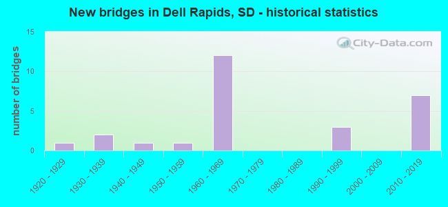
- New bridges - historical statistics
- 11920-1929
- 21930-1939
- 11940-1949
- 11950-1959
- 121960-1969
- 31990-1999
- 72010-2019

- Reconstructed bridges - Historical Statistics
- 11950-1959
- 11960-1969


- Bridge Condition - Deck
- 5.3%Very good
- 47.4%Good
- 26.3%Satisfactory
- 10.5%Fair
- 10.5%Poor

- Bridge Condition - Superstructure
- 5.3%Very good
- 36.8%Good
- 26.3%Satisfactory
- 26.3%Fair
- 5.3%Serious

- Bridge Condition - Substructure
- 63.2%Good
- 31.6%Satisfactory
- 5.3%Fair

- Bridge Condition - Channel
- 33.3%Very good
- 33.3%Good
- 33.3%Satisfactory

- Bridge Condition - Culverts
- 50.0%Good
- 50.0%Fair
Find on map >> Show street view
Structure Number: 5017501, Location: 1 N SD 115 INTERCH (Lat: 43.833678, Lng: -96.780614), Route carried "on" structure: Interstate 29, Year Built: 1963, Status: Open, Structure Length: 3.63m (11.91ft), Average Daily Traffic: 10,310 (year 2021), Truck Traffic: 14%, Average Future Daily Traffic: 15,517 (year 2041), Design Load: HS 20+Mod, Features Intersected: 245 ST
Minimum Vertical Clearance: 30+ m (98+ ft), Kilometerpoint: 160.114, Lanes on structure: 2, Lanes under structure: 2, Base Highway Network: Yes, Owner: State Highway Agency, Approaching Roadway Width: 11.6m (38.1ft), Material/Design: Concrete continuous, Design/Construction: Slab, Number Of Spans In Main Unit: 3, Length of Maximum Span: 12.8m (42.0ft), Curb-To-Curb Width: 11.6m (38.1ft), Out-to-Out Width: 12.9m (42.3ft)
Condition: Deck: Satisfactory, Superstructure: Satisfactory, Substructure: Good, Operating Rating: 63.6 metric tons, Method Used To Determine Operating Rating: Load Factor (LF), Inventory Rating: 38.1 metric tons, Method Used To Determine Inventory Rating: Load Factor (LF), Structural Evaluation: Equal to present minimum criteria, Deck Geometry: Equal to present minimum criteria, Underclear: Somewhat better than minimum adequacy, Approach Roadway Alignment: Equal to present desirable criteria, Designated Inspection Frequency: Every 24 months, Inspection Date: August 2020, Deck Structure Type: Concrete Cast-file-Place, Wearing Surface/Protective System: Wearing Surface: Epoxy Overlay, Membrane: Epoxy
Find on map >> Show street view
Structure Number: 5017502, Location: SD 115 & I29 INTERCHANGE (Lat: 43.819067, Lng: -96.780047), Route carried "on" structure: State highway 115, Year Built: 2017, Status: Open, Structure Length: 7.67m (25.16ft), Average Daily Traffic: 3,387 (year 2021), Truck Traffic: 9%, Average Future Daily Traffic: 5,246 (year 2041), Design Load: HL 93, Features Intersected: I029
Minimum Vertical Clearance: 30+ m (98+ ft), Kilometerpoint: 173.069, Lanes on structure: 2, Lanes under structure: 4, Base Highway Network: Yes, Owner: State Highway Agency, Approaching Roadway Width: 11.0m (36.1ft), Material/Design: Steel continuous, Design/Construction: Stringer/Multi-beam, Number Of Spans In Main Unit: 2, Length of Maximum Span: 38.9m (127.6ft), Curb-To-Curb Width: 15.8m (51.8ft), Out-to-Out Width: 16.7m (54.8ft)
Condition: Deck: Good, Superstructure: Good, Substructure: Good, Operating Rating: 52.7 metric tons, Method Used To Determine Operating Rating: Load and Resistance Factor (LRFR), Inventory Rating: 40.6 metric tons, Method Used To Determine Inventory Rating: Load and Resistance Factor (LRFR), Structural Evaluation: Better than present minimum criteria, Deck Geometry: Superior to present desirable criteria, Underclear: Better than present minimum criteria, Approach Roadway Alignment: Superior to present desirable criteria, Designated Inspection Frequency: Every 24 months, Inspection Date: November 2021, Deck Structure Type: Concrete Cast-file-Place, Wearing Surface/Protective System: Wearing Surface: Integral Concrete, Deck Protection: Epoxy Coated Reinforcing
Find on map >> Show street view
Structure Number: 5017601, Location: 1 N SD 115 INTERCH (Lat: 43.833675, Lng: -96.780269), Route carried "on" structure: Interstate 29, Year Built: 1963, Status: Open, Structure Length: 3.63m (11.91ft), Average Daily Traffic: 10,310 (year 2021), Truck Traffic: 14%, Average Future Daily Traffic: 15,517 (year 2041), Design Load: HS 20+Mod, Features Intersected: 245 ST
Minimum Vertical Clearance: 30+ m (98+ ft), Kilometerpoint: 160.114, Lanes on structure: 2, Lanes under structure: 2, Base Highway Network: Yes, Owner: State Highway Agency, Approaching Roadway Width: 11.6m (38.1ft), Material/Design: Concrete continuous, Design/Construction: Slab, Number Of Spans In Main Unit: 3, Length of Maximum Span: 13.1m (43.0ft), Curb-To-Curb Width: 11.6m (38.1ft), Out-to-Out Width: 12.9m (42.3ft)
Condition: Deck: Good, Superstructure: Good, Substructure: Good, Operating Rating: 42.7 metric tons, Method Used To Determine Operating Rating: Load Factor (LF), Inventory Rating: 25.6 metric tons, Method Used To Determine Inventory Rating: Load Factor (LF), Structural Evaluation: Equal to present minimum criteria, Deck Geometry: Equal to present minimum criteria, Underclear: Somewhat better than minimum adequacy, Approach Roadway Alignment: Equal to present desirable criteria, Designated Inspection Frequency: Every 24 months, Inspection Date: August 2020, Deck Structure Type: Concrete Cast-file-Place, Wearing Surface/Protective System: Wearing Surface: Epoxy Overlay, Membrane: Epoxy
Find on map >> Show street view
Structure Number: 50190012, Location: 1.4W & 0.5N DELL RAPIDS (Lat: 43.831339, Lng: -96.748842), Route carried "on" structure: County highway , Year Built: 1990, Status: Open, Structure Length: 2.04m (6.69ft), Average Daily Traffic: 39 (year 2019), Truck Traffic: 2%, Average Future Daily Traffic: 45 (year 2032), Features Intersected: TRIB TO BIG SIOUX RV, Facility Carried by Structure: 473RD AVENUE
Minimum Vertical Clearance: 30+ m (98+ ft), Kilometerpoint: 0.000, Lanes on structure: 2, Owner: County Highway Agency, Approaching Roadway Width: 7.3m (24.0ft), Material/Design: Prestressed concrete, Design/Construction: Tee Beam, Number Of Spans In Main Unit: 1, Length of Maximum Span: 19.8m (65.0ft), Curb-To-Curb Width: 9.7m (31.8ft), Out-to-Out Width: 9.8m (32.2ft)
Condition: Deck: Good, Superstructure: Good, Substructure: Good, Channel: Very good, Operating Rating: 32.7 metric tons, Method Used To Determine Operating Rating: Field evaluation and documented engineering judgment, Inventory Rating: 19.6 metric tons, Method Used To Determine Inventory Rating: Field evaluation and documented engineering judgment, Structural Evaluation: Somewhat better than minimum adequacy, Deck Geometry: Better than present minimum criteria, Waterway Adequacy: Equal to present desirable criteria, Approach Roadway Alignment: Equal to present desirable criteria, Length Of Structure Improvement: 2.80m (9.19ft), Designated Inspection Frequency: Every 24 months, Inspection Date: July 2021, Bridge Improvement Cost: $412,000, Roadway Improvement Cost: $41,000, Total Project Cost: $653,000 ( Estimate for 2017), Deck Structure Type: Concrete Precast Panels, Wearing Surface/Protective System: Wearing Surface: Monolithic Concrete
Find on map >> Show street view
Structure Number: 5019204, Location: 1.2W & 2.3S DELL RAPIDS (Lat: 43.790494, Lng: -96.745183), Route carried "on" structure: County highway , Year Built: 1964, Status: Open, Structure Length: 8.05m (26.41ft), Average Daily Traffic: 403 (year 2021), Truck Traffic: 2%, Average Future Daily Traffic: 500 (year 2036), Design Load: H 20, Features Intersected: BIG SIOUX RIVER, Facility Carried by Structure: 248TH ST, HWY 110
Minimum Vertical Clearance: 30+ m (98+ ft), Kilometerpoint: 0.000, Lanes on structure: 2, Owner: County Highway Agency, Approaching Roadway Width: 7.3m (24.0ft), Material/Design: Steel continuous, Design/Construction: Stringer/Multi-beam, Number Of Spans In Main Unit: 3, Length of Maximum Span: 30.5m (100.1ft), Curb-To-Curb Width: 9.1m (29.9ft), Out-to-Out Width: 9.8m (32.2ft)
Condition: Deck: Satisfactory, Superstructure: Fair, Substructure: Good, Channel: Satisfactory, Operating Rating: 42.8 metric tons, Method Used To Determine Operating Rating: Load Factor (LF), Inventory Rating: 25.7 metric tons, Method Used To Determine Inventory Rating: Load Factor (LF), Structural Evaluation: Somewhat better than minimum adequacy, Deck Geometry: Equal to present minimum criteria, Waterway Adequacy: Equal to present desirable criteria, Approach Roadway Alignment: Superior to present desirable criteria, Length Of Structure Improvement: 9.05m (29.69ft), Designated Inspection Frequency: Every 24 months, Inspection Date: June 2020, Bridge Improvement Cost: $1,397,000, Roadway Improvement Cost: $140,000, Total Project Cost: $2,044,000 ( Estimate for 2018), Deck Structure Type: Concrete Cast-file-Place, Wearing Surface/Protective System: Wearing Surface: Low Slump Concrete
Find on map >> Show street view
Structure Number: 50200035, Location: 1.8S & 0.4W DELL RAPIDS (Lat: 43.796461, Lng: -96.729125), Route carried "on" structure: County highway , Year Built: 1997, Status: Open, Structure Length: 4.75m (15.58ft), Average Daily Traffic: 27 (year 2020), Truck Traffic: 2%, Average Future Daily Traffic: 50 (year 2035), Design Load: HS 20+Mod, Features Intersected: BIG SIOUX RIVER, Facility Carried by Structure: 474TH AVENUE
Minimum Vertical Clearance: 30+ m (98+ ft), Kilometerpoint: 0.000, Lanes on structure: 2, Owner: County Highway Agency, Approaching Roadway Width: 6.7m (22.0ft), Skew: 2 degrees, Material/Design: Prestressed concrete, Design/Construction: Stringer/Multi-beam, Number Of Spans In Main Unit: 3, Length of Maximum Span: 16.3m (53.5ft), Curb-To-Curb Width: 9.8m (32.2ft), Out-to-Out Width: 10.5m (34.4ft)
Condition: Deck: Good, Superstructure: Good, Substructure: Good, Channel: Satisfactory, Operating Rating: 32.7 metric tons, Method Used To Determine Operating Rating: Field evaluation and documented engineering judgment, Inventory Rating: 19.6 metric tons, Method Used To Determine Inventory Rating: Field evaluation and documented engineering judgment, Structural Evaluation: Somewhat better than minimum adequacy, Deck Geometry: Equal to present desirable criteria, Waterway Adequacy: Equal to present desirable criteria, Approach Roadway Alignment: Superior to present desirable criteria, Length Of Structure Improvement: 5.75m (18.86ft), Designated Inspection Frequency: Every 24 months, Underwater Inspection Frequency: Every 60 months, Inspection Date: July 2021, Underwater Inspection Date: October 2018, Bridge Improvement Cost: $846,000, Roadway Improvement Cost: $85,000, Total Project Cost: $1,271,000 ( Estimate for 2017), Deck Structure Type: Concrete Cast-file-Place, Wearing Surface/Protective System: Wearing Surface: Monolithic Concrete
Find on map >> Show street view
Structure Number: 50202018, Location: THIRD ST-DELL RAPIDS (Lat: 43.822672, Lng: -96.719461), Route carried "on" structure: City street , Year Built: 1952, Status: Posted for load, Structure Length: 1.51m (4.95ft), Average Daily Traffic: 160 (year 2019), Truck Traffic: 2%, Average Future Daily Traffic: 220 (year 2032), Features Intersected: CK, Facility Carried by Structure: CITY STREET
Minimum Vertical Clearance: 30+ m (98+ ft), Kilometerpoint: 0.000, Lanes on structure: 2, Owner: Town or Township Highway Agency, Approaching Roadway Width: 9.1m (29.9ft), Skew: 3 degrees, Material/Design: Steel, Design/Construction: Stringer/Multi-beam, Number Of Spans In Main Unit: 1, Length of Maximum Span: 14.9m (48.9ft), Curb-To-Curb Width: 12.2m (40.0ft), Out-to-Out Width: 12.9m (42.3ft)
Condition: Deck: Fair, Superstructure: Serious, Substructure: Satisfactory, Channel: Very good, Operating Rating: 16.3 metric tons, Method Used To Determine Operating Rating: Field evaluation and documented engineering judgment, Inventory Rating: 9.8 metric tons, Method Used To Determine Inventory Rating: Field evaluation and documented engineering judgment, Structural Evaluation: High priority of replacement, Deck Geometry: Superior to present desirable criteria, Waterway Adequacy: Better than present minimum criteria, Approach Roadway Alignment: Better than present minimum criteria, Bridge Posting: Required (Relationship of Operating Rating to Maximum Legal Load: > 39.9% below), Length Of Structure Improvement: 2.19m (7.19ft), Designated Inspection Frequency: Every 12 months, Inspection Date: October 2021, Bridge Improvement Cost: $491,000, Roadway Improvement Cost: $49,000, Total Project Cost: $948,000 ( Estimate for 2021), Deck Structure Type: Concrete Cast-file-Place, Wearing Surface/Protective System: Wearing Surface: Monolithic Concrete
Find on map >> Show street view
Structure Number: 50203017, Location: 0.1 W OF DELL RAPIDS (Lat: 43.823483, Lng: -96.721119), Route carried "on" structure: State highway 115, Year Built: 2018, Status: Open, Structure Length: 1.75m (5.74ft), Average Daily Traffic: 3,451 (year 2021), Truck Traffic: 10%, Average Future Daily Traffic: 5,346 (year 2041), Design Load: HL 93, Features Intersected: CK
Minimum Vertical Clearance: 30+ m (98+ ft), Kilometerpoint: 168.289, Lanes on structure: 2, Base Highway Network: Yes, Owner: State Highway Agency, Approaching Roadway Width: 12.8m (42.0ft), Skew: 4 degrees, Material/Design: Steel, Design/Construction: Stringer/Multi-beam, Number Of Spans In Main Unit: 1, Length of Maximum Span: 16.7m (54.8ft), Curb or Sidewalk Widths: Left: 0.0m, Right: 2.4m (7.9ft), Curb-To-Curb Width: 12.8m (42.0ft), Out-to-Out Width: 16.3m (53.5ft)
Condition: Deck: Good, Superstructure: Good, Substructure: Good, Channel: Very good, Operating Rating: 47.9 metric tons, Method Used To Determine Operating Rating: Load and Resistance Factor (LRFR), Inventory Rating: 36.9 metric tons, Method Used To Determine Inventory Rating: Load and Resistance Factor (LRFR), Structural Evaluation: Better than present minimum criteria, Deck Geometry: Equal to present minimum criteria, Waterway Adequacy: Superior to present desirable criteria, Approach Roadway Alignment: Superior to present desirable criteria, Designated Inspection Frequency: Every 24 months, Inspection Date: September 2020, Deck Structure Type: Concrete Cast-file-Place, Wearing Surface/Protective System: Wearing Surface: Integral Concrete, Deck Protection: Epoxy Coated Reinforcing
Find on map >> Show street view
Structure Number: 5020602, Location: 0.2 S OF DELL RAPIDS (Lat: 43.820411, Lng: -96.716750), Route carried "on" structure: State highway 115, Year Built: 2018, Status: Open, Structure Length: 13.13m (43.08ft), Average Daily Traffic: 3,451 (year 2021), Truck Traffic: 10%, Average Future Daily Traffic: 5,346 (year 2041), Design Load: HL 93, Features Intersected: BIG SIOUX RV
Minimum Vertical Clearance: 30+ m (98+ ft), Kilometerpoint: 167.790, Lanes on structure: 2, Base Highway Network: Yes, Owner: State Highway Agency, Approaching Roadway Width: 12.8m (42.0ft), Skew: 3 degrees, Material/Design: Prestressed concrete, Design/Construction: Stringer/Multi-beam, Number Of Spans In Main Unit: 4, Length of Maximum Span: 33.5m (109.9ft), Curb or Sidewalk Widths: Left: 2.4m (7.9ft), Right: 0.0m, Curb-To-Curb Width: 12.8m (42.0ft), Out-to-Out Width: 17.3m (56.8ft)
Condition: Deck: Good, Superstructure: Good, Substructure: Good, Channel: Very good, Operating Rating: 48.1 metric tons, Method Used To Determine Operating Rating: Load and Resistance Factor (LRFR), Inventory Rating: 37.1 metric tons, Method Used To Determine Inventory Rating: Load and Resistance Factor (LRFR), Structural Evaluation: Better than present minimum criteria, Deck Geometry: Equal to present minimum criteria, Waterway Adequacy: Superior to present desirable criteria, Approach Roadway Alignment: Superior to present desirable criteria, Designated Inspection Frequency: Every 24 months, Underwater Inspection Frequency: Every 60 months, Inspection Date: September 2020, Deck Structure Type: Concrete Cast-file-Place, Wearing Surface/Protective System: Wearing Surface: Integral Concrete, Deck Protection: Epoxy Coated Reinforcing
Find on map >> Show street view
Structure Number: 50208022, Location: 0.5 S OF DELL RAPIDS (Lat: 43.817461, Lng: -96.713461), Route carried "on" structure: State highway 115, Year Built: 2016, Status: Open, Structure Length: 9.36m (30.71ft), Average Daily Traffic: 3,451 (year 2021), Truck Traffic: 10%, Average Future Daily Traffic: 5,346 (year 2041), Design Load: HL 93, Features Intersected: SOUTH FORK SIOUX RV
Minimum Vertical Clearance: 30+ m (98+ ft), Kilometerpoint: 167.356, Lanes on structure: 2, Base Highway Network: Yes, Owner: State Highway Agency, Approaching Roadway Width: 12.8m (42.0ft), Material/Design: Concrete continuous, Design/Construction: Slab, Number Of Spans In Main Unit: 7, Length of Maximum Span: 14.1m (46.3ft), Curb or Sidewalk Widths: Left: 2.4m (7.9ft), Right: 0.0m, Curb-To-Curb Width: 12.8m (42.0ft), Out-to-Out Width: 16.3m (53.5ft)
Condition: Deck: Good, Superstructure: Good, Substructure: Good, Channel: Good, Operating Rating: 51.2 metric tons, Method Used To Determine Operating Rating: Load and Resistance Factor (LRFR), Inventory Rating: 39.5 metric tons, Method Used To Determine Inventory Rating: Load and Resistance Factor (LRFR), Structural Evaluation: Better than present minimum criteria, Deck Geometry: Equal to present minimum criteria, Waterway Adequacy: Superior to present desirable criteria, Approach Roadway Alignment: Superior to present desirable criteria, Designated Inspection Frequency: Every 24 months, Underwater Inspection Frequency: Every 60 months, Inspection Date: September 2020, Underwater Inspection Date: November 2018, Deck Structure Type: Concrete Cast-file-Place, Wearing Surface/Protective System: Wearing Surface: Integral Concrete, Deck Protection: Epoxy Coated Reinforcing
Find on map >> Show street view
Structure Number: 50210018, Location: GARFIELD AVE-DELL RAPIDS (Lat: 43.820928, Lng: -96.706817), Route carried "on" structure: County highway , Year Built: 2014, Status: Open, Structure Length: 9.23m (30.28ft), Average Daily Traffic: 1,400 (year 2019), Truck Traffic: 5%, Average Future Daily Traffic: 1,430 (year 2032), Design Load: HL 93, Features Intersected: BIG SIOUX RIVER, Facility Carried by Structure: GARFIELD AVENUE
Minimum Vertical Clearance: 30+ m (98+ ft), Kilometerpoint: 0.000, Lanes on structure: 2, Owner: Town or Township Highway Agency, Approaching Roadway Width: 7.3m (24.0ft), Material/Design: Prestressed concrete, Design/Construction: Stringer/Multi-beam, Number Of Spans In Main Unit: 4, Length of Maximum Span: 22.9m (75.1ft), Curb or Sidewalk Widths: Left: 0.0m, Right: 2.4m (7.9ft), Curb-To-Curb Width: 9.1m (29.9ft), Out-to-Out Width: 12.5m (41.0ft)
Condition: Deck: Good, Superstructure: Very good, Substructure: Good, Channel: Very good, Operating Rating: 57.1 metric tons, Method Used To Determine Operating Rating: Load and Resistance Factor (LRFR), Inventory Rating: 44.0 metric tons, Method Used To Determine Inventory Rating: Load and Resistance Factor (LRFR), Structural Evaluation: Better than present minimum criteria, Deck Geometry: Somewhat better than minimum adequacy, Waterway Adequacy: Superior to present desirable criteria, Approach Roadway Alignment: Superior to present desirable criteria, Length Of Structure Improvement: 10.19m (33.43ft), Designated Inspection Frequency: Every 24 months, Inspection Date: September 2020, Bridge Improvement Cost: $2,106,000, Roadway Improvement Cost: $211,000, Total Project Cost: $3,210,000 ( Estimate for 2020), Deck Structure Type: Concrete Cast-file-Place, Wearing Surface/Protective System: Wearing Surface: Monolithic Concrete
Find on map >> Show street view
Structure Number: 5021501, Location: 1.1E & 0.7N DELL RAPIDS (Lat: 43.833244, Lng: -96.696403), Route carried "on" structure: County highway , Year Built: 2014, Status: Open, Structure Length: 1.25m (4.10ft), Average Daily Traffic: 33 (year 2020), Truck Traffic: 2%, Average Future Daily Traffic: 50 (year 2035), Design Load: HL 93, Features Intersected: TRIB TO BIG SIOUX RV, Facility Carried by Structure: 245TH ST / 15TH ST
Minimum Vertical Clearance: 30+ m (98+ ft), Kilometerpoint: 0.000, Lanes on structure: 2, Owner: County Highway Agency, Approaching Roadway Width: 6.7m (22.0ft), Skew: 4 degrees, Material/Design: Concrete continuous, Design/Construction: Culvert, Number Of Spans In Main Unit: 3, Length of Maximum Span: 4.0m (13.1ft)
Condition: Channel: Good, Culverts: Good, Operating Rating: 52.0 metric tons, Method Used To Determine Operating Rating: Load and Resistance Factor (LRFR), Inventory Rating: 40.1 metric tons, Method Used To Determine Inventory Rating: Load and Resistance Factor (LRFR), Structural Evaluation: Better than present minimum criteria, Waterway Adequacy: Better than present minimum criteria, Approach Roadway Alignment: Equal to present desirable criteria, Length Of Structure Improvement: 2.25m (7.38ft), Designated Inspection Frequency: Every 24 months, Inspection Date: July 2021, Bridge Improvement Cost: $276,000, Roadway Improvement Cost: $28,000, Total Project Cost: $467,000 ( Estimate for 2017)
Find on map >> Show street view
Structure Number: 50216015, Location: 1.2E & 0.2N DELL RAPIDS (Lat: 43.826022, Lng: -96.694106), Route carried "on" structure: County highway , Year Built: 1922, Year Reconstructed: 1966, Status: Open, Structure Length: 1.04m (3.41ft), Average Daily Traffic: 1,120 (year 2021), Truck Traffic: 3%, Average Future Daily Traffic: 1,400 (year 2036), Features Intersected: TRIB TO BIG SIOUX RV, Facility Carried by Structure: JASPER ST, HWY 104
Minimum Vertical Clearance: 30+ m (98+ ft), Kilometerpoint: 0.000, Lanes on structure: 2, Owner: County Highway Agency, Approaching Roadway Width: 7.3m (24.0ft), Material/Design: Concrete continuous, Design/Construction: Slab, Number Of Spans In Main Unit: 3, Length of Maximum Span: 3.4m (11.2ft), Curb-To-Curb Width: 9.2m (30.2ft), Out-to-Out Width: 10.4m (34.1ft)
Condition: Deck: Poor, Superstructure: Fair, Substructure: Fair, Channel: Satisfactory, Operating Rating: 32.7 metric tons, Method Used To Determine Operating Rating: Field evaluation and documented engineering judgment, Inventory Rating: 19.6 metric tons, Method Used To Determine Inventory Rating: Field evaluation and documented engineering judgment, Structural Evaluation: Somewhat better than minimum adequacy, Deck Geometry: Somewhat better than minimum adequacy, Waterway Adequacy: Equal to present desirable criteria, Approach Roadway Alignment: Equal to present desirable criteria, Length Of Structure Improvement: 1.71m (5.61ft), Designated Inspection Frequency: Every 24 months, Inspection Date: July 2020, Bridge Improvement Cost: $264,000, Roadway Improvement Cost: $26,000, Total Project Cost: $450,000 ( Estimate for 2018), Deck Structure Type: Concrete Cast-file-Place, Wearing Surface/Protective System: Wearing Surface: Bituminous
Find on map >> Show street view
Structure Number: 50219015, Location: 1.5E & 0.2N DELL RAPIDS (Lat: 43.825972, Lng: -96.687372), Route carried "on" structure: County highway , Year Built: 1938, Status: Open, Structure Length: 1.11m (3.64ft), Average Daily Traffic: 1,111 (year 2021), Truck Traffic: 3%, Average Future Daily Traffic: 1,400 (year 2036), Features Intersected: TRIB TO BIG SIOUX RV, Facility Carried by Structure: JASPER ST, HWY 104
Minimum Vertical Clearance: 30+ m (98+ ft), Kilometerpoint: 0.000, Lanes on structure: 2, Owner: County Highway Agency, Approaching Roadway Width: 7.3m (24.0ft), Skew: 3 degrees, Material/Design: Concrete continuous, Design/Construction: Slab, Number Of Spans In Main Unit: 2, Length of Maximum Span: 5.5m (18.0ft), Curb-To-Curb Width: 7.4m (24.3ft), Out-to-Out Width: 8.3m (27.2ft)
Condition: Deck: Poor, Superstructure: Fair, Substructure: Satisfactory, Channel: Good, Operating Rating: 32.7 metric tons, Method Used To Determine Operating Rating: Field evaluation and documented engineering judgment, Inventory Rating: 19.6 metric tons, Method Used To Determine Inventory Rating: Field evaluation and documented engineering judgment, Structural Evaluation: Somewhat better than minimum adequacy, Deck Geometry: Meets minimum limits, Waterway Adequacy: Better than present minimum criteria, Approach Roadway Alignment: Equal to present desirable criteria, Length Of Structure Improvement: 1.78m (5.84ft), Designated Inspection Frequency: Every 24 months, Inspection Date: July 2020, Bridge Improvement Cost: $275,000, Roadway Improvement Cost: $27,000, Total Project Cost: $462,000 ( Estimate for 2018), Deck Structure Type: Concrete Cast-file-Place, Wearing Surface/Protective System: Wearing Surface: Bituminous
Find on map >> Show street view
Structure Number: 50225015, Location: 2.1E & 0.2N DELL RAPIDS (Lat: 43.825806, Lng: -96.677494), Route carried "on" structure: County highway , Year Built: 1991, Status: Open, Structure Length: 8.60m (28.22ft), Average Daily Traffic: 1,093 (year 2021), Truck Traffic: 3%, Average Future Daily Traffic: 1,400 (year 2036), Design Load: HS 20+Mod, Features Intersected: BIG SIOUX RIVER, Facility Carried by Structure: JASPER ST, HWY 104
Minimum Vertical Clearance: 30+ m (98+ ft), Kilometerpoint: 0.000, Lanes on structure: 2, Owner: County Highway Agency, Approaching Roadway Width: 7.3m (24.0ft), Skew: 1 degrees, Material/Design: Concrete continuous, Design/Construction: Slab, Number Of Spans In Main Unit: 6, Length of Maximum Span: 15.2m (49.9ft), Curb-To-Curb Width: 9.8m (32.2ft), Out-to-Out Width: 10.6m (34.8ft)
Condition: Deck: Good, Superstructure: Satisfactory, Substructure: Good, Channel: Good, Operating Rating: 70.5 metric tons, Method Used To Determine Operating Rating: Load Factor (LF), Inventory Rating: 42.2 metric tons, Method Used To Determine Inventory Rating: Load Factor (LF), Structural Evaluation: Equal to present minimum criteria, Deck Geometry: Somewhat better than minimum adequacy, Waterway Adequacy: Equal to present desirable criteria, Approach Roadway Alignment: Equal to present desirable criteria, Length Of Structure Improvement: 9.59m (31.46ft), Designated Inspection Frequency: Every 24 months, Underwater Inspection Frequency: Every 60 months, Inspection Date: July 2020, Underwater Inspection Date: October 2018, Bridge Improvement Cost: $1,479,000, Roadway Improvement Cost: $148,000, Total Project Cost: $2,169,000 ( Estimate for 2018), Deck Structure Type: Concrete Cast-file-Place, Wearing Surface/Protective System: Wearing Surface: Monolithic Concrete
Find on map >> Show street view
Structure Number: 5022602, Location: 2.2E & 0.3S DELL RAPIDS (Lat: 43.818481, Lng: -96.676008), Route carried "on" structure: County highway , Year Built: 1940, Status: Posted for load, Structure Length: 1.21m (3.97ft), Average Daily Traffic: 16 (year 2020), Truck Traffic: 2%, Average Future Daily Traffic: 40 (year 2035), Features Intersected: TRIB TO BIG SIOUX RV, Facility Carried by Structure: 246TH STREET
Minimum Vertical Clearance: 30+ m (98+ ft), Kilometerpoint: 0.000, Lanes on structure: 2, Owner: County Highway Agency, Approaching Roadway Width: 6.1m (20.0ft), Material/Design: Steel, Design/Construction: Stringer/Multi-beam, Number Of Spans In Main Unit: 1, Length of Maximum Span: 11.7m (38.4ft), Curb-To-Curb Width: 6.2m (20.3ft), Out-to-Out Width: 6.6m (21.7ft)
Condition: Deck: Fair, Superstructure: Fair, Substructure: Satisfactory, Channel: Satisfactory, Operating Rating: 39.8 metric tons, Method Used To Determine Operating Rating: Load Factor (LF), Inventory Rating: 23.9 metric tons, Method Used To Determine Inventory Rating: Load Factor (LF), Structural Evaluation: Somewhat better than minimum adequacy, Deck Geometry: Somewhat better than minimum adequacy, Waterway Adequacy: Equal to present desirable criteria, Approach Roadway Alignment: Equal to present minimum criteria, Bridge Posting: Required (Relationship of Operating Rating to Maximum Legal Load: 10.0 - 19.9% below), Length Of Structure Improvement: 1.88m (6.17ft), Designated Inspection Frequency: Every 24 months, Inspection Date: July 2020, Bridge Improvement Cost: $291,000, Roadway Improvement Cost: $29,000, Total Project Cost: $481,000 ( Estimate for 2018), Deck Structure Type: Concrete Cast-file-Place, Wearing Surface/Protective System: Wearing Surface: Monolithic Concrete
Find on map >> Show street view
Structure Number: 50238, Location: 3.4E & 1.7N DELL RAPIDS (Lat: 43.848372, Lng: -96.656014), Route carried "on" structure: County highway , Year Built: 1969, Status: Open, Structure Length: 8.10m (26.57ft), Average Daily Traffic: 13 (year 2020), Truck Traffic: 2%, Average Future Daily Traffic: 100 (year 2035), Design Load: HS 20, Features Intersected: BIG SIOUX RIVER, Facility Carried by Structure: 244TH STREET
Minimum Vertical Clearance: 30+ m (98+ ft), Kilometerpoint: 0.000, Lanes on structure: 2, Owner: County Highway Agency, Approaching Roadway Width: 7.3m (24.0ft), Skew: 4 degrees, Material/Design: Steel continuous, Design/Construction: Stringer/Multi-beam, Number Of Spans In Main Unit: 3, Length of Maximum Span: 30.5m (100.1ft), Curb-To-Curb Width: 9.1m (29.9ft), Out-to-Out Width: 10.0m (32.8ft)
Condition: Deck: Satisfactory, Superstructure: Fair, Substructure: Satisfactory, Channel: Satisfactory, Operating Rating: 52.6 metric tons, Method Used To Determine Operating Rating: Load Factor (LF), Inventory Rating: 31.5 metric tons, Method Used To Determine Inventory Rating: Load Factor (LF), Structural Evaluation: Somewhat better than minimum adequacy, Deck Geometry: Better than present minimum criteria, Waterway Adequacy: Meets minimum limits, Approach Roadway Alignment: Equal to present desirable criteria, Length Of Structure Improvement: 9.10m (29.86ft), Designated Inspection Frequency: Every 24 months, Underwater Inspection Frequency: Every 60 months, Inspection Date: June 2020, Underwater Inspection Date: October 2018, Bridge Improvement Cost: $1,404,000, Roadway Improvement Cost: $140,000, Total Project Cost: $2,056,000 ( Estimate for 2018), Deck Structure Type: Concrete Cast-file-Place, Wearing Surface/Protective System: Wearing Surface: Bituminous
Find on map >> Show street view
Structure Number: 5106521, Location: 3.2 N MINNEHAHA CO LINE (Lat: 43.891869, Lng: -96.758075), Route carried "on" structure: County highway , Year Built: 1963, Status: Open, Structure Length: 7.74m (25.39ft), Average Daily Traffic: 85 (year 2020), Truck Traffic: 5%, Average Future Daily Traffic: 85 (year 2040), Design Load: HS 20, Features Intersected: I029, Facility Carried by Structure: 241 ST
Minimum Vertical Clearance: 30+ m (98+ ft), Kilometerpoint: 0.000, Lanes on structure: 2, Lanes under structure: 4, Owner: State Highway Agency, Approaching Roadway Width: 9.1m (29.9ft), Material/Design: Steel continuous, Design/Construction: Stringer/Multi-beam, Number Of Spans In Main Unit: 4, Length of Maximum Span: 21.3m (69.9ft), Curb-To-Curb Width: 9.1m (29.9ft), Out-to-Out Width: 9.9m (32.5ft)
Condition: Deck: Very good, Superstructure: Satisfactory, Substructure: Satisfactory, Operating Rating: 58.4 metric tons, Method Used To Determine Operating Rating: Load Factor (LF), Inventory Rating: 35.0 metric tons, Method Used To Determine Inventory Rating: Load Factor (LF), Structural Evaluation: Equal to present minimum criteria, Deck Geometry: Better than present minimum criteria, Underclear: Somewhat better than minimum adequacy, Approach Roadway Alignment: Equal to present minimum criteria, Designated Inspection Frequency: Every 24 months, Inspection Date: Febuary 2022, Deck Structure Type: Concrete Cast-file-Place, Wearing Surface/Protective System: Wearing Surface: Epoxy Overlay, Membrane: Epoxy
Find on map >> Show street view
Structure Number: 5106523, Location: 1.2 N MINNEHAHA CO LINE (Lat: 43.863008, Lng: -96.759042), Route carried "on" structure: Interstate 29, Year Built: 1963, Status: Open, Structure Length: 3.63m (11.91ft), Average Daily Traffic: 10,310 (year 2021), Truck Traffic: 14%, Average Future Daily Traffic: 15,517 (year 2041), Design Load: HS 20+Mod, Features Intersected: 243 ST
Minimum Vertical Clearance: 30+ m (98+ ft), Kilometerpoint: 163.847, Lanes on structure: 2, Lanes under structure: 2, Base Highway Network: Yes, Owner: State Highway Agency, Approaching Roadway Width: 11.6m (38.1ft), Skew: 2 degrees, Material/Design: Concrete continuous, Design/Construction: Slab, Number Of Spans In Main Unit: 3, Length of Maximum Span: 12.8m (42.0ft), Curb-To-Curb Width: 11.6m (38.1ft), Out-to-Out Width: 12.9m (42.3ft)
Condition: Deck: Satisfactory, Superstructure: Satisfactory, Substructure: Good, Operating Rating: 54.2 metric tons, Method Used To Determine Operating Rating: Load Factor (LF), Inventory Rating: 32.5 metric tons, Method Used To Determine Inventory Rating: Load Factor (LF), Structural Evaluation: Equal to present minimum criteria, Deck Geometry: Equal to present minimum criteria, Underclear: Meets minimum limits, Approach Roadway Alignment: Equal to present desirable criteria, Designated Inspection Frequency: Every 24 months, Inspection Date: July 2020, Deck Structure Type: Concrete Cast-file-Place, Wearing Surface/Protective System: Wearing Surface: Epoxy Overlay, Membrane: Epoxy
Find on map >> Show street view
Structure Number: 5106623, Location: 1.2 N MINNEHAHA CO LINE (Lat: 43.863011, Lng: -96.758669), Route carried "on" structure: Interstate 29, Year Built: 1963, Status: Open, Structure Length: 3.63m (11.91ft), Average Daily Traffic: 10,310 (year 2021), Truck Traffic: 14%, Average Future Daily Traffic: 15,517 (year 2041), Design Load: HS 20+Mod, Features Intersected: 243 ST
Minimum Vertical Clearance: 30+ m (98+ ft), Kilometerpoint: 163.847, Lanes on structure: 2, Lanes under structure: 2, Base Highway Network: Yes, Owner: State Highway Agency, Approaching Roadway Width: 11.6m (38.1ft), Skew: 2 degrees, Material/Design: Concrete continuous, Design/Construction: Slab, Number Of Spans In Main Unit: 3, Length of Maximum Span: 13.1m (43.0ft), Curb-To-Curb Width: 11.6m (38.1ft), Out-to-Out Width: 12.9m (42.3ft)
Condition: Deck: Satisfactory, Superstructure: Satisfactory, Substructure: Satisfactory, Operating Rating: 64.8 metric tons, Method Used To Determine Operating Rating: Load Factor (LF), Inventory Rating: 35.9 metric tons, Method Used To Determine Inventory Rating: Load Factor (LF), Structural Evaluation: Equal to present minimum criteria, Deck Geometry: Equal to present minimum criteria, Underclear: Meets minimum limits, Approach Roadway Alignment: Equal to present desirable criteria, Designated Inspection Frequency: Every 24 months, Inspection Date: July 2020, Deck Structure Type: Concrete Cast-file-Place, Wearing Surface/Protective System: Wearing Surface: Epoxy Overlay, Membrane: Epoxy
Find on map >> Show street view
Structure Number: 5109924, Location: 4S & 1.2W of Trent (Lat: 43.848258, Lng: -96.688261), Route carried "on" structure: County highway , Year Built: 1939, Year Reconstructed: 1950, Status: Open, Structure Length: 0.98m (3.22ft), Average Daily Traffic: 348 (year 2019), Truck Traffic: 3%, Average Future Daily Traffic: 348 (year 2032), Design Load: H 15, Features Intersected: Trib. to Big Sioux River, Facility Carried by Structure: 244th Street
Minimum Vertical Clearance: 30+ m (98+ ft), Kilometerpoint: 0.000, Lanes on structure: 2, Owner: County Highway Agency, Approaching Roadway Width: 9.1m (29.9ft), Material/Design: Concrete continuous, Design/Construction: Culvert, Number Of Spans In Main Unit: 2, Length of Maximum Span: 3.0m (9.8ft)
Condition: Channel: Good, Culverts: Fair, Operating Rating: 32.7 metric tons, Method Used To Determine Operating Rating: Field evaluation and documented engineering judgment, Inventory Rating: 24.5 metric tons, Method Used To Determine Inventory Rating: Field evaluation and documented engineering judgment, Structural Evaluation: Somewhat better than minimum adequacy, Waterway Adequacy: Better than present minimum criteria, Approach Roadway Alignment: Better than present minimum criteria, Designated Inspection Frequency: Every 24 months, Inspection Date: August 2020
Find on map >> Show street view
Structure Number: 5017501, Location: 1 N SD 115 INTERCH (Lat: 43.833678, Lng: -96.780614), Route carried "under" structure: County highway , Year Built: 1963, Structure Length: 0. m, Average Daily Traffic: 85 (year 2020), Truck Traffic: 1%, Features Intersected: 245 ST, Facility Carried by Structure: I029 S
Minimum Vertical Clearance: 4.93m (16.17ft), Kilometerpoint: 0.000, Lanes on structure: 2, Lanes under structure: 2, Material/Design: Concrete continuous, Design/Construction: Slab, Length of Maximum Span: 12.8m (42.0ft)
Find on map >> Show street view
Structure Number: 5017502, Location: SD 115 & I29 INTERCHANGE (Lat: 43.819067, Lng: -96.780047), Route carried "under" structure: Interstate 29, Year Built: 2017, Structure Length: 0. m, Average Daily Traffic: 15,650 (year 2020), Truck Traffic: 21%, Features Intersected: I029, Facility Carried by Structure: SD115
Minimum Vertical Clearance: 5.56m (18.24ft), Kilometerpoint: 158.488, Lanes on structure: 2, Lanes under structure: 4, Material/Design: Steel continuous, Design/Construction: Stringer/Multi-beam, Length of Maximum Span: 38.9m (127.6ft)
Find on map >> Show street view
Structure Number: 5017601, Location: 1 N SD 115 INTERCH (Lat: 43.833675, Lng: -96.780269), Route carried "under" structure: County highway , Year Built: 1963, Structure Length: 0. m, Average Daily Traffic: 85 (year 2020), Truck Traffic: 1%, Features Intersected: 245 ST, Facility Carried by Structure: I029 N
Minimum Vertical Clearance: 4.50m (14.76ft), Kilometerpoint: 0.000, Lanes on structure: 2, Lanes under structure: 2, Material/Design: Concrete continuous, Design/Construction: Slab, Length of Maximum Span: 13.1m (43.0ft)
Find on map >> Show street view
Structure Number: 5106521, Location: 3.2 N MINNEHAHA CO LINE (Lat: 43.891869, Lng: -96.758075), Route carried "under" structure: Interstate 29, Year Built: 1963, Structure Length: 0. m, Average Daily Traffic: 15,650 (year 2020), Truck Traffic: 21%, Features Intersected: I029, Facility Carried by Structure: 241 ST
Minimum Vertical Clearance: 5.08m (16.67ft), Kilometerpoint: 167.066, Lanes on structure: 2, Lanes under structure: 4, Material/Design: Steel continuous, Design/Construction: Stringer/Multi-beam, Length of Maximum Span: 21.3m (69.9ft)
Find on map >> Show street view
Structure Number: 5106523, Location: 1.2 N MINNEHAHA CO LINE (Lat: 43.863008, Lng: -96.759042), Route carried "under" structure: County highway , Year Built: 1963, Structure Length: 0. m, Average Daily Traffic: 130 (year 2020), Truck Traffic: 5%, Features Intersected: 243 ST, Facility Carried by Structure: I029 S
Minimum Vertical Clearance: 4.52m (14.83ft), Kilometerpoint: 0.000, Lanes on structure: 2, Lanes under structure: 2, Material/Design: Concrete continuous, Design/Construction: Slab, Length of Maximum Span: 12.8m (42.0ft)
Find on map >> Show street view
Structure Number: 5106623, Location: 1.2 N MINNEHAHA CO LINE (Lat: 43.863011, Lng: -96.758669), Route carried "under" structure: County highway , Year Built: 1963, Structure Length: 0. m, Average Daily Traffic: 130 (year 2020), Truck Traffic: 5%, Features Intersected: 243 ST, Facility Carried by Structure: I029 N
Minimum Vertical Clearance: 4.80m (15.75ft), Kilometerpoint: 0.000, Lanes on structure: 2, Lanes under structure: 2, Material/Design: Concrete continuous, Design/Construction: Slab, Length of Maximum Span: 13.1m (43.0ft)