Bridge Statistics for Denton, Maryland (MD)
Condition, Traffic, Stress, Structural Evaluation, Project Costs
- National Bridge Inventory (NBI) Statistics
- 21Number of bridges
- 148ft / 45.0mTotal length
- $6,445,000Total costs
- 154,866Total average daily traffic
- 8,738Total average daily truck traffic
- National Bridge Inventory (NBI) Registered Bridges for Denton
- No street view available for this location
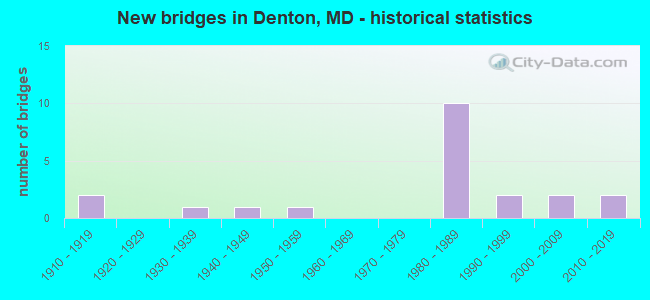
- New bridges - historical statistics
- 21910-1919
- 11930-1939
- 11940-1949
- 11950-1959
- 101980-1989
- 21990-1999
- 22000-2009
- 22010-2019


- Bridge Condition - Deck
- 60.0%Good
- 33.3%Satisfactory
- 6.7%Fair

- Bridge Condition - Superstructure
- 6.7%Very good
- 60.0%Good
- 26.7%Satisfactory
- 6.7%Poor

- Bridge Condition - Substructure
- 26.7%Good
- 53.3%Satisfactory
- 20.0%Fair

- Bridge Condition - Channel
- 36.4%Very good
- 9.1%Good
- 36.4%Satisfactory
- 18.2%Fair
Find on map >> Show street view
Structure Number: 10000005000702, Location: 0.5 MILE NORTH OF MD 317 (Lat: 38.911933, Lng: -75.817964), Route carried "on" structure: State highway 313, Year Built: 1954, Status: Open, Structure Length: 1.26m (4.13ft), Average Daily Traffic: 7,160 (year 2009), Truck Traffic: 8%, Average Future Daily Traffic: 8,440 (year 2026), Design Load: H 20, Features Intersected: CHAPEL BRANCH
Minimum Vertical Clearance: 30+ m (98+ ft), Kilometerpoint: 32.883, Lanes on structure: 2, Base Highway Network: Yes, Owner: State Highway Agency, Approaching Roadway Width: 13.4m (44.0ft), Skew: 1 degrees, Material/Design: Concrete, Design/Construction: Culvert, Length of Maximum Span: 6.1m (20.0ft)
Condition: Channel: Very good, Culverts: Satisfactory, Operating Rating: 87.1 metric tons, Method Used To Determine Operating Rating: Load Factor (LF), Inventory Rating: 52.6 metric tons, Method Used To Determine Inventory Rating: Load Factor (LF), Structural Evaluation: Equal to present minimum criteria, Waterway Adequacy: Equal to present desirable criteria, Approach Roadway Alignment: Equal to present desirable criteria, Designated Inspection Frequency: Every 24 months, Inspection Date: September 2021
Find on map >> Show street view
Structure Number: 100000050008013, Location: 0.25 MILE WEST OF MD 16 (Lat: 38.854411, Lng: -75.819219), Route carried "on" structure: State highway 404, Year Built: 1949, Year Reconstructed: 1986, Status: Open, Structure Length: 6.13m (20.11ft), Average Daily Traffic: 18,941 (year 2009), Truck Traffic: 10%, Average Future Daily Traffic: 9,289 (year 2026), Design Load: HS 20, Features Intersected: WATTS CREEK
Minimum Vertical Clearance: 30+ m (98+ ft), Kilometerpoint: 17.292, Lanes on structure: 2, Base Highway Network: Yes, Owner: State Highway Agency, Approaching Roadway Width: 13.4m (44.0ft), Material/Design: Steel, Design/Construction: Stringer/Multi-beam, Number Of Spans In Main Unit: 4, Length of Maximum Span: 15.2m (49.9ft), Curb-To-Curb Width: 11.3m (37.1ft), Out-to-Out Width: 11.8m (38.7ft)
Condition: Deck: Satisfactory, Superstructure: Satisfactory, Substructure: Satisfactory, Channel: Very good, Operating Rating: 79.8 metric tons, Method Used To Determine Operating Rating: Load Factor (LF), Inventory Rating: 47.6 metric tons, Method Used To Determine Inventory Rating: Load Factor (LF), Structural Evaluation: Equal to present minimum criteria, Deck Geometry: Equal to present minimum criteria, Waterway Adequacy: Superior to present desirable criteria, Approach Roadway Alignment: Equal to present desirable criteria, Designated Inspection Frequency: Every 24 months, Underwater Inspection Frequency: Every 48 months, Inspection Date: Febuary 2020, Underwater Inspection Date: June 2019, Deck Structure Type: Concrete Cast-file-Place, Wearing Surface/Protective System: Wearing Surface: Monolithic Concrete, Deck Protection: Epoxy Coated Reinforcing
Find on map >> Show street view
Structure Number: 100000050008014, Location: 0.25 MILE WEST OF MD 16 (Lat: 38.853975, Lng: -75.818486), Route carried "on" structure: Bypass State highway 404, Year Built: 2006, Status: Open, Structure Length: 7.47m (24.51ft), Average Daily Traffic: 18,941 (year 2009), Truck Traffic: 6%, Average Future Daily Traffic: 9,289 (year 2026), Design Load: HS 25 or greater, Features Intersected: WATTS CREEK
Minimum Vertical Clearance: 30+ m (98+ ft), Kilometerpoint: 17.292, Lanes on structure: 2, Base Highway Network: Yes, Owner: State Highway Agency, Approaching Roadway Width: 11.6m (38.1ft), Material/Design: Concrete continuous, Design/Construction: Stringer/Multi-beam, Number Of Spans In Main Unit: 4, Length of Maximum Span: 18.3m (60.0ft), Curb-To-Curb Width: 12.2m (40.0ft), Out-to-Out Width: 13.4m (44.0ft)
Condition: Deck: Satisfactory, Superstructure: Very good, Substructure: Good, Channel: Very good, Operating Rating: 67.1 metric tons, Method Used To Determine Operating Rating: Load Factor (LF), Inventory Rating: 36.3 metric tons, Method Used To Determine Inventory Rating: Load Factor (LF), Structural Evaluation: Better than present minimum criteria, Deck Geometry: Better than present minimum criteria, Waterway Adequacy: Superior to present desirable criteria, Approach Roadway Alignment: Equal to present desirable criteria, Designated Inspection Frequency: Every 24 months, Inspection Date: Febuary 2020, Deck Structure Type: Concrete Cast-file-Place, Wearing Surface/Protective System: Wearing Surface: Monolithic Concrete, Deck Protection: Epoxy Coated Reinforcing
Find on map >> Show street view
Structure Number: 100000050027013, Location: 0.99 MILE EAST OF MD 328 (Lat: 38.894897, Lng: -75.819611), Route carried "on" structure: State highway 404, Year Built: 1987, Status: Open, Structure Length: 3.57m (11.71ft), Average Daily Traffic: 15,421 (year 2009), Truck Traffic: 8%, Average Future Daily Traffic: 8,378 (year 2026), Design Load: HS 20, Features Intersected: MD 313
Minimum Vertical Clearance: 30+ m (98+ ft), Kilometerpoint: 11.937, Lanes on structure: 2, Lanes under structure: 3, Base Highway Network: Yes, Owner: State Highway Agency, Approaching Roadway Width: 11.6m (38.1ft), Skew: 1 degrees, Material/Design: Steel, Design/Construction: Stringer/Multi-beam, Number Of Spans In Main Unit: 1, Length of Maximum Span: 34.1m (111.9ft), Curb-To-Curb Width: 12.2m (40.0ft), Out-to-Out Width: 13.2m (43.3ft)
Condition: Deck: Good, Superstructure: Good, Substructure: Satisfactory, Operating Rating: 90.2 metric tons, Method Used To Determine Operating Rating: Load Factor (LF), Inventory Rating: 62.6 metric tons, Method Used To Determine Inventory Rating: Load Factor (LF), Structural Evaluation: Equal to present minimum criteria, Deck Geometry: Better than present minimum criteria, Underclear: Better than present minimum criteria, Approach Roadway Alignment: Equal to present desirable criteria, Designated Inspection Frequency: Every 24 months, Inspection Date: August 2021, Deck Structure Type: Concrete Cast-file-Place, Wearing Surface/Protective System: Wearing Surface: Monolithic Concrete, Deck Protection: Epoxy Coated Reinforcing
Find on map >> Show street view
Structure Number: 100000050027014, Location: 0.99 MILE EAST OF MD 328 (Lat: 38.895025, Lng: -75.819089), Route carried "on" structure: State highway 404, Year Built: 1987, Status: Open, Structure Length: 3.57m (11.71ft), Average Daily Traffic: 15,421 (year 2009), Truck Traffic: 8%, Average Future Daily Traffic: 8,378 (year 2026), Design Load: HS 20, Features Intersected: MD 313
Minimum Vertical Clearance: 30+ m (98+ ft), Kilometerpoint: 11.937, Lanes on structure: 2, Lanes under structure: 4, Base Highway Network: Yes, Owner: State Highway Agency, Approaching Roadway Width: 11.6m (38.1ft), Skew: 1 degrees, Material/Design: Steel, Design/Construction: Stringer/Multi-beam, Number Of Spans In Main Unit: 1, Length of Maximum Span: 34.1m (111.9ft), Curb-To-Curb Width: 12.2m (40.0ft), Out-to-Out Width: 13.2m (43.3ft)
Condition: Deck: Good, Superstructure: Good, Substructure: Satisfactory, Operating Rating: 90.2 metric tons, Method Used To Determine Operating Rating: Load Factor (LF), Inventory Rating: 62.6 metric tons, Method Used To Determine Inventory Rating: Load Factor (LF), Structural Evaluation: Equal to present minimum criteria, Deck Geometry: Better than present minimum criteria, Underclear: Better than present minimum criteria, Approach Roadway Alignment: Equal to present desirable criteria, Designated Inspection Frequency: Every 24 months, Inspection Date: August 2021, Deck Structure Type: Concrete Cast-file-Place, Wearing Surface/Protective System: Wearing Surface: Monolithic Concrete, Deck Protection: Epoxy Coated Reinforcing
Find on map >> Show street view
Structure Number: 10000005002801, Location: 0.54 MI E OF MD 313 (Lat: 38.891550, Lng: -75.814069), Route carried "on" structure: City street 35, Year Built: 1987, Status: Open, Structure Length: 6.55m (21.49ft), Average Daily Traffic: 999 (year 1994), Truck Traffic: 5%, Average Future Daily Traffic: 1,178 (year 2012), Design Load: HS 20, Features Intersected: MD 404, Facility Carried by Structure: CAMP ROAD
Minimum Vertical Clearance: 30+ m (98+ ft), Kilometerpoint: 0.869, Lanes on structure: 2, Lanes under structure: 4, Owner: State Highway Agency, Approaching Roadway Width: 10.4m (34.1ft), Material/Design: Steel continuous, Design/Construction: Stringer/Multi-beam, Number Of Spans In Main Unit: 2, Length of Maximum Span: 33.5m (109.9ft), Curb-To-Curb Width: 10.4m (34.1ft), Out-to-Out Width: 11.3m (37.1ft)
Condition: Deck: Satisfactory, Superstructure: Satisfactory, Substructure: Fair, Operating Rating: 70.7 metric tons, Method Used To Determine Operating Rating: Load Factor (LF), Inventory Rating: 42.6 metric tons, Method Used To Determine Inventory Rating: Load Factor (LF), Structural Evaluation: Somewhat better than minimum adequacy, Deck Geometry: Equal to present minimum criteria, Underclear: Superior to present desirable criteria, Approach Roadway Alignment: Equal to present desirable criteria, Designated Inspection Frequency: Every 24 months, Inspection Date: October 2021, Deck Structure Type: Concrete Cast-file-Place, Wearing Surface/Protective System: Wearing Surface: Monolithic Concrete, Deck Protection: Epoxy Coated Reinforcing
Find on map >> Show street view
Structure Number: 100000050029013, Location: 0.46 MI W OF MD 404 BU (Lat: 38.883822, Lng: -75.814583), Route carried "on" structure: State highway 404, Year Built: 1987, Status: Open, Structure Length: 2.74m (8.99ft), Average Daily Traffic: 15,421 (year 2009), Truck Traffic: 8%, Average Future Daily Traffic: 8,378 (year 2026), Design Load: HS 20, Features Intersected: MARKET STREET
Minimum Vertical Clearance: 30+ m (98+ ft), Kilometerpoint: 13.454, Lanes on structure: 2, Lanes under structure: 2, Base Highway Network: Yes, Owner: State Highway Agency, Approaching Roadway Width: 11.6m (38.1ft), Material/Design: Steel, Design/Construction: Stringer/Multi-beam, Number Of Spans In Main Unit: 1, Length of Maximum Span: 26.2m (86.0ft), Curb-To-Curb Width: 12.2m (40.0ft), Out-to-Out Width: 13.2m (43.3ft)
Condition: Deck: Good, Superstructure: Good, Substructure: Satisfactory, Operating Rating: 90.2 metric tons, Method Used To Determine Operating Rating: Load Factor (LF), Inventory Rating: 63.0 metric tons, Method Used To Determine Inventory Rating: Load Factor (LF), Structural Evaluation: Equal to present minimum criteria, Deck Geometry: Better than present minimum criteria, Underclear: Meets minimum limits, Approach Roadway Alignment: Equal to present desirable criteria, Designated Inspection Frequency: Every 24 months, Inspection Date: October 2021, Deck Structure Type: Concrete Cast-file-Place, Wearing Surface/Protective System: Wearing Surface: Monolithic Concrete, Deck Protection: Epoxy Coated Reinforcing
Find on map >> Show street view
Structure Number: 100000050029014, Location: 0.46 MI W OF MD 404 BU (Lat: 38.883608, Lng: -75.814328), Route carried "on" structure: State highway 404, Year Built: 1987, Status: Open, Structure Length: 2.74m (8.99ft), Average Daily Traffic: 15,421 (year 2009), Truck Traffic: 8%, Average Future Daily Traffic: 8,378 (year 2026), Design Load: HS 20, Features Intersected: MARKET STREET
Minimum Vertical Clearance: 30+ m (98+ ft), Kilometerpoint: 13.454, Lanes on structure: 2, Lanes under structure: 2, Base Highway Network: Yes, Owner: State Highway Agency, Approaching Roadway Width: 11.6m (38.1ft), Material/Design: Steel, Design/Construction: Stringer/Multi-beam, Number Of Spans In Main Unit: 1, Length of Maximum Span: 26.2m (86.0ft), Curb-To-Curb Width: 12.2m (40.0ft), Out-to-Out Width: 13.2m (43.3ft)
Condition: Deck: Good, Superstructure: Good, Substructure: Satisfactory, Operating Rating: 90.2 metric tons, Method Used To Determine Operating Rating: Load Factor (LF), Inventory Rating: 63.0 metric tons, Method Used To Determine Inventory Rating: Load Factor (LF), Structural Evaluation: Equal to present minimum criteria, Deck Geometry: Better than present minimum criteria, Underclear: Somewhat better than minimum adequacy, Approach Roadway Alignment: Equal to present desirable criteria, Designated Inspection Frequency: Every 24 months, Inspection Date: October 2021, Deck Structure Type: Concrete Cast-file-Place, Wearing Surface/Protective System: Wearing Surface: Monolithic Concrete, Deck Protection: Epoxy Coated Reinforcing
Find on map >> Show street view
Structure Number: 200000CO001501, Location: 2.0 MILES NORTH OF MD 317 (Lat: 38.924111, Lng: -75.757667), Route carried "on" structure: County highway 65, Year Built: 1996, Status: Open, Structure Length: 1.65m (5.41ft), Average Daily Traffic: 740 (year 2021), Truck Traffic: 1%, Average Future Daily Traffic: 1,099 (year 2041), Design Load: HS 20, Features Intersected: GAREY MILL POND BRANCH, Facility Carried by Structure: KNIFE BOX ROAD
Minimum Vertical Clearance: 30+ m (98+ ft), Kilometerpoint: 5.519, Lanes on structure: 2, Owner: County Highway Agency, Approaching Roadway Width: 6.4m (21.0ft), Material/Design: Wood or Timber, Design/Construction: Slab, Number Of Spans In Main Unit: 2, Length of Maximum Span: 7.9m (25.9ft), Curb-To-Curb Width: 9.1m (29.9ft), Out-to-Out Width: 9.8m (32.2ft)
Condition: Deck: Good, Superstructure: Good, Substructure: Satisfactory, Channel: Satisfactory, Operating Rating: 44.4 metric tons, Method Used To Determine Operating Rating: Allowable Stress (AS), Inventory Rating: 31.7 metric tons, Method Used To Determine Inventory Rating: Allowable Stress (AS), Structural Evaluation: Equal to present minimum criteria, Deck Geometry: Equal to present minimum criteria, Waterway Adequacy: Equal to present minimum criteria, Approach Roadway Alignment: Equal to present desirable criteria, Designated Inspection Frequency: Every 24 months, Underwater Inspection Frequency: Every 48 months, Inspection Date: December 2021, Underwater Inspection Date: December 2021, Deck Structure Type: Wood or Timber, Wearing Surface/Protective System: Wearing Surface: Bituminous
Find on map >> Show street view
Structure Number: 200000CO001601, Location: 0.5 MILES NORTH OF MD 317 (Lat: 38.915167, Lng: -75.792472), Route carried "on" structure: County highway 66, Year Built: 2017, Status: Open, Structure Length: 1.76m (5.77ft), Average Daily Traffic: 1,431 (year 2019), Truck Traffic: 1%, Average Future Daily Traffic: 3,800 (year 2039), Features Intersected: GARLAND LAKE, Facility Carried by Structure: GARLAND ROAD
Minimum Vertical Clearance: 30+ m (98+ ft), Kilometerpoint: 3.685, Lanes on structure: 2, Owner: County Highway Agency, Approaching Roadway Width: 9.1m (29.9ft), Material/Design: Prestressed concrete, Design/Construction: Slab, Number Of Spans In Main Unit: 1, Length of Maximum Span: 16.5m (54.1ft), Curb-To-Curb Width: 9.4m (30.8ft), Out-to-Out Width: 10.4m (34.1ft)
Condition: Deck: Good, Superstructure: Good, Substructure: Good, Channel: Very good, Operating Rating: 60.3 metric tons, Method Used To Determine Operating Rating: Load and Resistance Factor Rating (LRFR) rating reported by rating factor(RF) method using HL-93 loadings, Inventory Rating: 46.7 metric tons, Method Used To Determine Inventory Rating: Load and Resistance Factor Rating (LRFR) rating reported by rating factor(RF) method using HL-93 loadings, Structural Evaluation: Better than present minimum criteria, Deck Geometry: Somewhat better than minimum adequacy, Waterway Adequacy: Equal to present minimum criteria, Approach Roadway Alignment: Equal to present minimum criteria, Designated Inspection Frequency: Every 24 months, Inspection Date: December 2021, Deck Structure Type: Concrete Cast-file-Place, Wearing Surface/Protective System: Wearing Surface: Monolithic Concrete
Find on map >> Show street view
Structure Number: 200000CO002401, Location: 2.0 MILES SOUTH OF MD 317 (Lat: 38.880086, Lng: -75.782903), Route carried "on" structure: County highway 111, Year Built: 2004, Status: Open, Structure Length: 1.80m (5.91ft), Average Daily Traffic: 558 (year 2019), Truck Traffic: 1%, Average Future Daily Traffic: 1,490 (year 2039), Design Load: HS 20, Features Intersected: WATTS CREEK, Facility Carried by Structure: ANTHONY MILL ROAD
Minimum Vertical Clearance: 30+ m (98+ ft), Kilometerpoint: 1.287, Lanes on structure: 2, Owner: County Highway Agency, Approaching Roadway Width: 7.6m (24.9ft), Material/Design: Wood or Timber, Design/Construction: Slab, Number Of Spans In Main Unit: 2, Length of Maximum Span: 8.5m (27.9ft), Curb-To-Curb Width: 9.1m (29.9ft), Out-to-Out Width: 9.8m (32.2ft)
Condition: Deck: Good, Superstructure: Good, Substructure: Satisfactory, Channel: Good, Operating Rating: 59.0 metric tons, Method Used To Determine Operating Rating: Allowable Stress (AS), Inventory Rating: 42.2 metric tons, Method Used To Determine Inventory Rating: Allowable Stress (AS), Structural Evaluation: Equal to present minimum criteria, Deck Geometry: Equal to present minimum criteria, Waterway Adequacy: Superior to present desirable criteria, Approach Roadway Alignment: Equal to present desirable criteria, Designated Inspection Frequency: Every 24 months, Underwater Inspection Frequency: Every 48 months, Inspection Date: December 2021, Underwater Inspection Date: December 2021, Deck Structure Type: Wood or Timber, Wearing Surface/Protective System: Wearing Surface: Bituminous, Membrane: Other, Deck Protection: Internally Sealed
Find on map >> Show street view
Structure Number: 200000CO002501, Location: 1 MI SE OF DENTON (Lat: 38.874903, Lng: -75.791608), Route carried "on" structure: County highway 107, Year Built: 1936, Status: Posted for load, Structure Length: 1.16m (3.81ft), Average Daily Traffic: 1,915 (year 2021), Truck Traffic: 2%, Average Future Daily Traffic: 5,083 (year 2042), Features Intersected: WATTS CREEK, Facility Carried by Structure: HOBBS ROAD
Minimum Vertical Clearance: 30+ m (98+ ft), Kilometerpoint: 7.192, Lanes on structure: 2, Owner: County Highway Agency, Approaching Roadway Width: 6.1m (20.0ft), Material/Design: Steel, Design/Construction: Stringer/Multi-beam, Number Of Spans In Main Unit: 1, Length of Maximum Span: 11.3m (37.1ft), Curb-To-Curb Width: 9.2m (30.2ft), Out-to-Out Width: 10.2m (33.5ft)
Condition: Deck: Satisfactory, Superstructure: Satisfactory, Substructure: Fair, Channel: Satisfactory, Operating Rating: 46.3 metric tons, Method Used To Determine Operating Rating: Load Factor (LF), Inventory Rating: 27.7 metric tons, Method Used To Determine Inventory Rating: Load Factor (LF), Structural Evaluation: Somewhat better than minimum adequacy, Deck Geometry: Somewhat better than minimum adequacy, Waterway Adequacy: Equal to present minimum criteria, Approach Roadway Alignment: Equal to present desirable criteria, Designated Inspection Frequency: Every 24 months, Underwater Inspection Frequency: Every 48 months, Inspection Date: December 2021, Underwater Inspection Date: December 2021, Deck Structure Type: Concrete Cast-file-Place, Wearing Surface/Protective System: Wearing Surface: Bituminous
Find on map >> Show street view
Structure Number: 200000CO002601, Location: 0.5 MI SE OF DENTON (Lat: 38.863044, Lng: -75.808161), Route carried "on" structure: County highway 114, Year Built: 2011, Status: Open, Structure Length: 1.43m (4.69ft), Average Daily Traffic: 904 (year 2020), Truck Traffic: 1%, Average Future Daily Traffic: 2,400 (year 2040), Design Load: HS 20, Features Intersected: WATTS CREEK, Facility Carried by Structure: LEGION ROAD
Minimum Vertical Clearance: 30+ m (98+ ft), Kilometerpoint: 2.220, Lanes on structure: 2, Owner: County Highway Agency, Approaching Roadway Width: 9.1m (29.9ft), Material/Design: Prestressed concrete, Design/Construction: Slab, Number Of Spans In Main Unit: 1, Length of Maximum Span: 13.4m (44.0ft), Curb-To-Curb Width: 9.1m (29.9ft), Out-to-Out Width: 10.1m (33.1ft)
Condition: Deck: Good, Superstructure: Good, Substructure: Good, Channel: Satisfactory, Inventory Rating: 56.2 metric tons, Method Used To Determine Inventory Rating: Load Factor (LF), Structural Evaluation: Better than present minimum criteria, Deck Geometry: Equal to present minimum criteria, Waterway Adequacy: Equal to present minimum criteria, Approach Roadway Alignment: Equal to present minimum criteria, Length Of Structure Improvement: 2.44m (8.01ft), Designated Inspection Frequency: Every 24 months, Inspection Date: January 2020, Bridge Improvement Cost: $3,500,000, Roadway Improvement Cost: $2,700,000, Total Project Cost: $6,200,000 ( Estimate for 2018), Deck Structure Type: Concrete Cast-file-Place, Wearing Surface/Protective System: Wearing Surface: Integral Concrete
Find on map >> Show street view
Structure Number: 200000CO002701, Location: 0.47 MI NE OF MD 404 (Lat: 38.857486, Lng: -75.815336), Route carried "on" structure: County highway 372, Year Built: 1913, Status: Posted for load, Structure Length: 1.04m (3.41ft), Average Daily Traffic: 509 (year 2021), Truck Traffic: 1%, Average Future Daily Traffic: 1,360 (year 2041), Design Load: HS 20, Features Intersected: WATTS CREEK, Facility Carried by Structure: DOUBLE HILL ROAD
Minimum Vertical Clearance: 30+ m (98+ ft), Kilometerpoint: 0.756, Lanes on structure: 2, Owner: County Highway Agency, Approaching Roadway Width: 5.8m (19.0ft), Material/Design: Concrete, Design/Construction: Stringer/Multi-beam, Number Of Spans In Main Unit: 1, Length of Maximum Span: 10.1m (33.1ft), Curb-To-Curb Width: 6.6m (21.7ft), Out-to-Out Width: 7.5m (24.6ft)
Condition: Deck: Fair, Superstructure: Poor, Substructure: Fair, Channel: Fair, Operating Rating: 37.2 metric tons, Method Used To Determine Operating Rating: Load Factor (LF), Inventory Rating: 22.2 metric tons, Method Used To Determine Inventory Rating: Load Factor (LF), Structural Evaluation: Meets minimum limits, Deck Geometry: High priority of corrective action, Waterway Adequacy: Somewhat better than minimum adequacy, Approach Roadway Alignment: Equal to present minimum criteria, Bridge Posting: Required (Relationship of Operating Rating to Maximum Legal Load: 10.0 - 19.9% below), Length Of Structure Improvement: 1.22m (4.00ft), Designated Inspection Frequency: Every 12 months, Underwater Inspection Frequency: Every 48 months, Inspection Date: January 2021, Underwater Inspection Date: January 2018, Bridge Improvement Cost: $15,000, Roadway Improvement Cost: $14,000, Total Project Cost: $29,000, Deck Structure Type: Concrete Cast-file-Place, Wearing Surface/Protective System: Wearing Surface: Bituminous
Find on map >> Show street view
Structure Number: 200000CO004501, Location: 0.22 MI NE OF MD 404 (Lat: 38.851778, Lng: -75.810250), Route carried "on" structure: County highway 115, Year Built: 1993, Status: Open, Structure Length: 1.31m (4.30ft), Average Daily Traffic: 537 (year 2019), Truck Traffic: 13%, Average Future Daily Traffic: 1,430 (year 2039), Design Load: HS 20, Features Intersected: HERRING RUN, Facility Carried by Structure: SENNETT ROAD
Minimum Vertical Clearance: 30+ m (98+ ft), Kilometerpoint: 2.430, Lanes on structure: 2, Owner: County Highway Agency, Approaching Roadway Width: 6.1m (20.0ft), Material/Design: Wood or Timber, Design/Construction: Slab, Number Of Spans In Main Unit: 2, Length of Maximum Span: 7.3m (24.0ft), Curb or Sidewalk Widths: Left: 0.3m (1.0ft), Right: 0.3m (1.0ft), Curb-To-Curb Width: 9.1m (29.9ft), Out-to-Out Width: 9.8m (32.2ft)
Condition: Deck: Good, Superstructure: Good, Substructure: Good, Channel: Fair, Operating Rating: 55.3 metric tons, Method Used To Determine Operating Rating: Allowable Stress (AS), Inventory Rating: 39.5 metric tons, Method Used To Determine Inventory Rating: Allowable Stress (AS), Structural Evaluation: Better than present minimum criteria, Deck Geometry: Equal to present minimum criteria, Waterway Adequacy: Equal to present desirable criteria, Approach Roadway Alignment: Equal to present desirable criteria, Designated Inspection Frequency: Every 24 months, Inspection Date: December 2021, Deck Structure Type: Wood or Timber, Wearing Surface/Protective System: Wearing Surface: Bituminous, Deck Protection: Internally Sealed
Find on map >> Show street view
Structure Number: 200000CO004901, Location: 0.25 MI NE OF MD 404 (Lat: 38.854583, Lng: -75.814003), Route carried "on" structure: County highway 372, Year Built: 1913, Status: Posted for load, Structure Length: 0.85m (2.79ft), Average Daily Traffic: 446 (year 2020), Truck Traffic: 2%, Average Future Daily Traffic: 1,190 (year 2040), Features Intersected: HERRING RUN, Facility Carried by Structure: DOUBLE HILLS ROAD
Minimum Vertical Clearance: 30+ m (98+ ft), Kilometerpoint: 0.402, Lanes on structure: 2, Owner: County Highway Agency, Approaching Roadway Width: 6.1m (20.0ft), Material/Design: Concrete, Design/Construction: Tee Beam, Number Of Spans In Main Unit: 1, Length of Maximum Span: 8.2m (26.9ft), Curb-To-Curb Width: 6.7m (22.0ft), Out-to-Out Width: 7.3m (24.0ft)
Condition: Deck: Satisfactory, Superstructure: Satisfactory, Substructure: Satisfactory, Channel: Satisfactory, Operating Rating: 37.6 metric tons, Method Used To Determine Operating Rating: Load Factor (LF), Inventory Rating: 22.2 metric tons, Method Used To Determine Inventory Rating: Load Factor (LF), Structural Evaluation: Equal to present minimum criteria, Deck Geometry: Meets minimum limits, Waterway Adequacy: Somewhat better than minimum adequacy, Approach Roadway Alignment: Equal to present minimum criteria, Bridge Posting: Required (Relationship of Operating Rating to Maximum Legal Load: 10.0 - 19.9% below), Length Of Structure Improvement: 1.07m (3.51ft), Designated Inspection Frequency: Every 12 months, Inspection Date: December 2021, Bridge Improvement Cost: $196,000, Roadway Improvement Cost: $20,000, Total Project Cost: $216,000, Deck Structure Type: Concrete Cast-file-Place, Wearing Surface/Protective System: Wearing Surface: Bituminous
Find on map >> Show street view
Structure Number: 100000050027013, Location: 0.77 MILE SOUTH OF MD 317 (Lat: 38.894897, Lng: -75.819611), Route carried "under" structure: State highway 313, Year Built: 1987, Structure Length: 0. m, Average Daily Traffic: 10,860 (year 2009), Features Intersected: MD 313, Facility Carried by Structure: MD 404 EBR
Minimum Vertical Clearance: 30+ m (98+ ft), Kilometerpoint: 30.828, Lanes on structure: 2, Lanes under structure: 4, Material/Design: Steel, Design/Construction: Stringer/Multi-beam, Length of Maximum Span: 34.1m (111.9ft)
Find on map >> Show street view
Structure Number: 100000050027014, Location: 0.77 MILE SOUTH OF MD 317 (Lat: 38.895025, Lng: -75.819089), Route carried "under" structure: State highway 313, Year Built: 1987, Structure Length: 0. m, Average Daily Traffic: 10,860 (year 2009), Features Intersected: MD 313, Facility Carried by Structure: MD 404 WBR
Minimum Vertical Clearance: 30+ m (98+ ft), Kilometerpoint: 30.828, Lanes on structure: 2, Lanes under structure: 4, Material/Design: Steel, Design/Construction: Stringer/Multi-beam, Length of Maximum Span: 34.1m (111.9ft)
Find on map >> Show street view
Structure Number: 10000005002801, Location: .39 MI. W. OF MD 313 (Lat: 38.891550, Lng: -75.814069), Route carried "under" structure: State highway 404, Year Built: 1987, Structure Length: 0. m, Average Daily Traffic: 15,421 (year 2009), Features Intersected: MD 404, Facility Carried by Structure: CAMP ROAD
Minimum Vertical Clearance: 5.18m (16.99ft), Kilometerpoint: 12.582, Lanes on structure: 2, Lanes under structure: 4, Material/Design: Steel continuous, Length of Maximum Span: 33.5m (109.9ft)
Find on map >> Show street view
Structure Number: 100000050029013, Location: 0.46 MI W OF MD 404 BU (Lat: 38.883822, Lng: -75.814583), Route carried "under" structure: Business City street 170, Year Built: 1987, Structure Length: 0. m, Average Daily Traffic: 1,480 (year 2010), Features Intersected: MARKET STREET, Facility Carried by Structure: MD 404 EBR
Minimum Vertical Clearance: 30+ m (98+ ft), Kilometerpoint: 1.770, Lanes on structure: 2, Lanes under structure: 2, Material/Design: Steel, Design/Construction: Stringer/Multi-beam, Length of Maximum Span: 26.2m (86.0ft)
Find on map >> Show street view
Structure Number: 100000050029014, Location: 0.46 MI W OF MD 404 BU (Lat: 38.883608, Lng: -75.814328), Route carried "under" structure: Business City street 170, Year Built: 1987, Structure Length: 0. m, Average Daily Traffic: 1,480 (year 2010), Features Intersected: MARKET STREET, Facility Carried by Structure: MD 404 WBR
Minimum Vertical Clearance: 30+ m (98+ ft), Kilometerpoint: 1.770, Lanes on structure: 2, Lanes under structure: 2, Material/Design: Steel, Design/Construction: Stringer/Multi-beam, Length of Maximum Span: 26.2m (86.0ft)