Bridge Statistics for Deville, Louisiana (LA)
Condition, Traffic, Stress, Structural Evaluation, Project Costs
- National Bridge Inventory (NBI) Statistics
- 13Number of bridges
- 135ft / 41.3mTotal length
- $1,143,000Total costs
- 30,770Total average daily traffic
- 4,889Total average daily truck traffic
- 30,671Total future (year 2036) average daily traffic
- National Bridge Inventory (NBI) Registered Bridges for Deville
- No street view available for this location
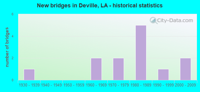
- New bridges - historical statistics
- 11930-1939
- 21960-1969
- 21970-1979
- 51980-1989
- 11990-1999
- 22000-2009


- Bridge Condition - Deck
- 50.0%Good
- 30.0%Satisfactory
- 20.0%Fair

- Bridge Condition - Superstructure
- 40.0%Good
- 40.0%Satisfactory
- 20.0%Fair

- Bridge Condition - Substructure
- 30.0%Good
- 50.0%Satisfactory
- 10.0%Poor
- 10.0%Serious

- Bridge Condition - Channel
- 30.8%Good
- 38.5%Satisfactory
- 30.8%Fair
Find on map >> Show street view
Structure Number: 84000000080295, Location: 2.5 MI. EAST OF LA 1206 (Lat: 31.387539, Lng: -92.125600), Route carried "on" structure: County highway , Year Built: 2008, Status: Open, Structure Length: 4.27m (14.01ft), Average Daily Traffic: 350 (year 2004), Average Future Daily Traffic: 455 (year 2036), Design Load: HS 20, Features Intersected: SALINE BAYOU, Facility Carried by Structure: Paul Rd
Minimum Vertical Clearance: 30+ m (98+ ft), Kilometerpoint: 0.000, Lanes on structure: 2, Owner: County Highway Agency, Approaching Roadway Width: 6.7m (22.0ft), Skew: 30 degrees, Material/Design: Concrete, Design/Construction: Slab, Number Of Spans In Main Unit: 7, Length of Maximum Span: 6.1m (20.0ft), Curb-To-Curb Width: 7.2m (23.6ft), Out-to-Out Width: 8.1m (26.6ft)
Condition: Deck: Good, Superstructure: Good, Substructure: Good, Channel: Good, Operating Rating: 51.5 metric tons, Method Used To Determine Operating Rating: Load and Resistance Factor Rating (LRFR) rating reported by rating factor(RF) method using HL-93 loadings, Inventory Rating: 39.9 metric tons, Method Used To Determine Inventory Rating: Load and Resistance Factor Rating (LRFR) rating reported by rating factor(RF) method using HL-93 loadings, Structural Evaluation: Better than present minimum criteria, Deck Geometry: Meets minimum limits, Waterway Adequacy: Meets minimum limits, Approach Roadway Alignment: Somewhat better than minimum adequacy, Designated Inspection Frequency: Every 24 months, Underwater Inspection Frequency: Every 60 months, Inspection Date: September 2021, Underwater Inspection Date: September 2018, Deck Structure Type: Concrete Precast Panels, Wearing Surface/Protective System: Wearing Surface: Monolithic Concrete
Find on map >> Show street view
Structure Number: 84000330400001, Location: 5.66 MI. NORTH OF LA 107 (Lat: 31.300631, Lng: -92.156819), Route carried "on" structure: State highway 115, Year Built: 1980, Status: Open, Structure Length: 10.70m (35.10ft), Average Daily Traffic: 3,200 (year 2016), Truck Traffic: 14%, Average Future Daily Traffic: 4,160 (year 2036), Design Load: HS 20, Features Intersected: BIG CREEK
Minimum Vertical Clearance: 30+ m (98+ ft), Kilometerpoint: 0.003, Lanes on structure: 2, Owner: State Highway Agency, Approaching Roadway Width: 12.2m (40.0ft), Skew: 30 degrees, Material/Design: Prestressed concrete continuous, Design/Construction: Stringer/Multi-beam, Number Of Spans In Main Unit: 7, Length of Maximum Span: 15.2m (49.9ft), Curb-To-Curb Width: 12.2m (40.0ft), Out-to-Out Width: 13.0m (42.7ft)
Condition: Deck: Good, Superstructure: Fair, Substructure: Satisfactory, Channel: Good, Operating Rating: 69.8 metric tons, Method Used To Determine Operating Rating: Load Factor (LF), Inventory Rating: 32.7 metric tons, Method Used To Determine Inventory Rating: Load Factor (LF), Structural Evaluation: Somewhat better than minimum adequacy, Deck Geometry: Equal to present minimum criteria, Waterway Adequacy: Better than present minimum criteria, Approach Roadway Alignment: Better than present minimum criteria, Designated Inspection Frequency: Every 24 months, Underwater Inspection Frequency: Every 60 months, Inspection Date: May 2020, Underwater Inspection Date: May 2020, Deck Structure Type: Concrete Cast-file-Place, Wearing Surface/Protective System: Wearing Surface: Monolithic Concrete
Find on map >> Show street view
Structure Number: 84000330406801, Location: 2.26 MI. SOUTH OF LA 28 (Lat: 31.396939, Lng: -92.164500), Route carried "on" structure: State highway 115, Year Built: 2001, Status: Open, Structure Length: 4.82m (15.81ft), Average Daily Traffic: 1,660 (year 2016), Truck Traffic: 14%, Average Future Daily Traffic: 2,132 (year 2036), Design Load: HS 20, Features Intersected: WATERS BAYOU
Minimum Vertical Clearance: 30+ m (98+ ft), Kilometerpoint: 10.849, Lanes on structure: 2, Owner: State Highway Agency, Approaching Roadway Width: 10.4m (34.1ft), Skew: 30 degrees, Material/Design: Concrete, Design/Construction: Slab, Number Of Spans In Main Unit: 8, Length of Maximum Span: 6.1m (20.0ft), Curb-To-Curb Width: 11.8m (38.7ft), Out-to-Out Width: 12.6m (41.3ft)
Condition: Deck: Good, Superstructure: Good, Substructure: Good, Channel: Satisfactory, Operating Rating: 74.4 metric tons, Method Used To Determine Operating Rating: Load Factor (LF), Inventory Rating: 44.4 metric tons, Method Used To Determine Inventory Rating: Load Factor (LF), Structural Evaluation: Better than present minimum criteria, Deck Geometry: Equal to present minimum criteria, Waterway Adequacy: Equal to present minimum criteria, Approach Roadway Alignment: Equal to present desirable criteria, Designated Inspection Frequency: Every 24 months, Inspection Date: December 2020, Deck Structure Type: Concrete Cast-file-Place, Wearing Surface/Protective System: Wearing Surface: Monolithic Concrete
Find on map >> Show street view
Structure Number: 84000740208901, Location: 2.19 MI. EAST OF LA 1207 (Lat: 31.410969, Lng: -92.205700), Route carried "on" structure: State highway 28, Year Built: 1931, Status: Open, Structure Length: 0.70m (2.30ft), Average Daily Traffic: 5,100 (year 2016), Truck Traffic: 15%, Average Future Daily Traffic: 6,500 (year 2036), Design Load: H 15, Features Intersected: WATERS CREEK
Minimum Vertical Clearance: 30+ m (98+ ft), Kilometerpoint: 13.998, Lanes on structure: 2, Base Highway Network: Yes (Inventory Route: 74-02-1, Subroute: 10), Owner: State Highway Agency, Approaching Roadway Width: 13.4m (44.0ft), Skew: 30 degrees, Material/Design: Concrete, Design/Construction: Culvert, Number Of Spans In Main Unit: 5, Length of Maximum Span: 1.2m (3.9ft)
Condition: Channel: Satisfactory, Culverts: Satisfactory, Operating Rating: 42.1 metric tons, Method Used To Determine Operating Rating: Load and Resistance Factor Rating (LRFR) rating reported by rating factor(RF) method using HL-93 loadings, Inventory Rating: 32.4 metric tons, Method Used To Determine Inventory Rating: Load and Resistance Factor Rating (LRFR) rating reported by rating factor(RF) method using HL-93 loadings, Structural Evaluation: Equal to present minimum criteria, Waterway Adequacy: Better than present minimum criteria, Approach Roadway Alignment: Better than present minimum criteria, Designated Inspection Frequency: Every 24 months, Inspection Date: August 2020, Deck Structure Type: Concrete Cast-file-Place
Find on map >> Show street view
Structure Number: 84003670101201, Location: 1.2 MI. WEST OF LA 115 (Lat: 31.364189, Lng: -92.182900), Route carried "on" structure: State highway 1207, Year Built: 1980, Status: Open, Structure Length: 1.16m (3.81ft), Average Daily Traffic: 5,000 (year 2016), Truck Traffic: 14%, Average Future Daily Traffic: 6,500 (year 2036), Design Load: HS 20, Features Intersected: SLASH BRANCH
Minimum Vertical Clearance: 30+ m (98+ ft), Kilometerpoint: 1.864, Lanes on structure: 2, Owner: State Highway Agency, Approaching Roadway Width: 9.1m (29.9ft), Skew: 30 degrees, Material/Design: Concrete, Design/Construction: Slab, Number Of Spans In Main Unit: 2, Length of Maximum Span: 5.8m (19.0ft), Curb-To-Curb Width: 8.5m (27.9ft), Out-to-Out Width: 9.1m (29.9ft)
Condition: Deck: Satisfactory, Superstructure: Satisfactory, Substructure: Satisfactory, Channel: Fair, Operating Rating: 62.6 metric tons, Method Used To Determine Operating Rating: Load Factor (LF), Inventory Rating: 37.2 metric tons, Method Used To Determine Inventory Rating: Load Factor (LF), Structural Evaluation: Equal to present minimum criteria, Deck Geometry: Meets minimum limits, Waterway Adequacy: Better than present minimum criteria, Approach Roadway Alignment: Equal to present desirable criteria, Designated Inspection Frequency: Every 24 months, Inspection Date: December 2020, Deck Structure Type: Concrete Precast Panels, Wearing Surface/Protective System: Wearing Surface: Bituminous
Find on map >> Show street view
Structure Number: 84008400101321, Location: 1.32 MILES EAST OF LA 115 (Lat: 31.337419, Lng: -92.143000), Route carried "on" structure: State highway 1206, Year Built: 1975, Status: Posted for load, Structure Length: 1.22m (4.00ft), Average Daily Traffic: 920 (year 2016), Truck Traffic: 10%, Average Future Daily Traffic: 1,209 (year 2036), Design Load: HS 20, Features Intersected: CREEK
Minimum Vertical Clearance: 30+ m (98+ ft), Kilometerpoint: 2.111, Lanes on structure: 2, Owner: State Highway Agency, Approaching Roadway Width: 7.9m (25.9ft), Skew: 30 degrees, Material/Design: Wood or Timber, Design/Construction: Stringer/Multi-beam, Number Of Spans In Main Unit: 2, Length of Maximum Span: 6.1m (20.0ft), Curb-To-Curb Width: 8.8m (28.9ft), Out-to-Out Width: 9.2m (30.2ft)
Condition: Deck: Fair, Superstructure: Fair, Substructure: Serious, Channel: Fair, Operating Rating: 19.0 metric tons, Method Used To Determine Operating Rating: Allowable Stress (AS), Inventory Rating: 13.6 metric tons, Method Used To Determine Inventory Rating: Allowable Stress (AS), Structural Evaluation: High priority of corrective action, Deck Geometry: Somewhat better than minimum adequacy, Waterway Adequacy: Better than present minimum criteria, Approach Roadway Alignment: Better than present minimum criteria, Bridge Posting: Required (Relationship of Operating Rating to Maximum Legal Load: 20.0 - 29.9% below), Length Of Structure Improvement: 1.89m (6.20ft), Designated Inspection Frequency: Every 24 months, Other Special Inspection Frequency: Every 12 months, Inspection Date: December 2020, Other Special Inspection Date: December 2021, Bridge Improvement Cost: $161,000, Total Project Cost: $241,000 ( Estimate for 2016), Deck Structure Type: Wood or Timber, Wearing Surface/Protective System: Wearing Surface: Bituminous
Find on map >> Show street view
Structure Number: 84008400104681, Location: 4.68 MI. EAST OF LA 115 (Lat: 31.366261, Lng: -92.140300), Route carried "on" structure: State highway 1206, Year Built: 1998, Status: Open, Structure Length: 1.25m (4.10ft), Average Daily Traffic: 920 (year 2016), Truck Traffic: 10%, Average Future Daily Traffic: 1,209 (year 2036), Design Load: HS 20, Features Intersected: ISLAND BAYOU
Minimum Vertical Clearance: 30+ m (98+ ft), Kilometerpoint: 7.620, Lanes on structure: 2, Owner: State Highway Agency, Approaching Roadway Width: 7.3m (24.0ft), Skew: 30 degrees, Material/Design: Steel, Design/Construction: Culvert, Number Of Spans In Main Unit: 4, Length of Maximum Span: 2.4m (7.9ft)
Condition: Channel: Satisfactory, Culverts: Satisfactory, Operating Rating: 97.2 metric tons, Method Used To Determine Operating Rating: Load and Resistance Factor Rating (LRFR) rating reported by rating factor(RF) method using HL-93 loadings, Inventory Rating: 74.5 metric tons, Method Used To Determine Inventory Rating: Load and Resistance Factor Rating (LRFR) rating reported by rating factor(RF) method using HL-93 loadings, Structural Evaluation: Equal to present minimum criteria, Waterway Adequacy: Equal to present desirable criteria, Approach Roadway Alignment: Better than present minimum criteria, Designated Inspection Frequency: Every 24 months, Inspection Date: December 2020
Find on map >> Show street view
Structure Number: 84031205921301, Location: 4.09 MI. ENE OF LA 1205 (Lat: 31.342269, Lng: -92.217400), Route carried "on" structure: County highway , Year Built: 1980, Status: Posted for load, Structure Length: 2.47m (8.10ft), Average Daily Traffic: 200 (year 1976), Average Future Daily Traffic: 260 (year 2036), Design Load: HS 20, Features Intersected: HAINES CREEK, Facility Carried by Structure: Philadelphia Rd
Minimum Vertical Clearance: 30+ m (98+ ft), Kilometerpoint: 7.142, Lanes on structure: 2, Owner: County Highway Agency, Approaching Roadway Width: 7.6m (24.9ft), Skew: 30 degrees, Material/Design: Prestressed concrete, Design/Construction: Channel Beam, Number Of Spans In Main Unit: 4, Length of Maximum Span: 6.1m (20.0ft), Curb-To-Curb Width: 7.0m (23.0ft), Out-to-Out Width: 7.4m (24.3ft)
Condition: Deck: Fair, Superstructure: Satisfactory, Substructure: Poor, Channel: Fair, Operating Rating: 13.9 metric tons, Method Used To Determine Operating Rating: Load and Resistance Factor Rating (LRFR) rating reported by rating factor(RF) method using HL-93 loadings, Inventory Rating: 10.7 metric tons, Method Used To Determine Inventory Rating: Load and Resistance Factor Rating (LRFR) rating reported by rating factor(RF) method using HL-93 loadings, Structural Evaluation: High priority of corrective action, Deck Geometry: Meets minimum limits, Waterway Adequacy: Better than present minimum criteria, Approach Roadway Alignment: Somewhat better than minimum adequacy, Bridge Posting: Required (Relationship of Operating Rating to Maximum Legal Load: > 39.9% below), Designated Inspection Frequency: Every 24 months, Underwater Inspection Frequency: Every 60 months, Other Special Inspection Frequency: Every 6 months, Inspection Date: April 2021, Underwater Inspection Date: September 2018, Other Special Inspection Date: October 2021, Deck Structure Type: Concrete Precast Panels, Wearing Surface/Protective System: Wearing Surface: Monolithic Concrete
Find on map >> Show street view
Structure Number: 84031223921131, Location: 4.07 MI. SOUTH OF LA 28 (Lat: 31.372281, Lng: -92.188200), Route carried "on" structure: County highway , Year Built: 1976, Status: Posted for load, Structure Length: 1.10m (3.61ft), Average Daily Traffic: 280 (year 1976), Average Future Daily Traffic: 364 (year 2036), Design Load: H 10, Features Intersected: SLASH BAYOU TRIB., Facility Carried by Structure: Bethel Rd
Minimum Vertical Clearance: 30+ m (98+ ft), Kilometerpoint: 6.511, Lanes on structure: 2, Owner: County Highway Agency, Approaching Roadway Width: 5.8m (19.0ft), Skew: 30 degrees, Material/Design: Wood or Timber, Design/Construction: Stringer/Multi-beam, Number Of Spans In Main Unit: 2, Length of Maximum Span: 5.5m (18.0ft), Curb-To-Curb Width: 6.6m (21.7ft), Out-to-Out Width: 6.9m (22.6ft)
Condition: Deck: Good, Superstructure: Good, Substructure: Satisfactory, Channel: Good, Operating Rating: 16.3 metric tons, Method Used To Determine Operating Rating: Allowable Stress (AS), Inventory Rating: 10.9 metric tons, Method Used To Determine Inventory Rating: Allowable Stress (AS), Structural Evaluation: Meets minimum limits, Deck Geometry: Meets minimum limits, Waterway Adequacy: Equal to present minimum criteria, Approach Roadway Alignment: Somewhat better than minimum adequacy, Bridge Posting: Required (Relationship of Operating Rating to Maximum Legal Load: 20.0 - 29.9% below), Length Of Structure Improvement: 1.74m (5.71ft), Designated Inspection Frequency: Every 24 months, Inspection Date: September 2021, Bridge Improvement Cost: $103,000, Total Project Cost: $154,000 ( Estimate for 2016), Deck Structure Type: Wood or Timber, Wearing Surface/Protective System: Wearing Surface: Bituminous
Find on map >> Show street view
Structure Number: 84031229921011, Location: 0.3 MI. WEST OF LA 115 (Lat: 31.381900, Lng: -92.168400), Route carried "on" structure: County highway , Year Built: 1985, Status: Open, Structure Length: 0.79m (2.59ft), Average Daily Traffic: 160 (year 1983), Average Future Daily Traffic: 208 (year 2036), Design Load: HS 20, Features Intersected: SLASH BAYOU, Facility Carried by Structure: Bert Paul Rd
Minimum Vertical Clearance: 30+ m (98+ ft), Kilometerpoint: 1.059, Lanes on structure: 2, Owner: County Highway Agency, Approaching Roadway Width: 5.5m (18.0ft), Skew: 30 degrees, Material/Design: Concrete, Design/Construction: Culvert, Number Of Spans In Main Unit: 3, Length of Maximum Span: 2.1m (6.9ft)
Condition: Channel: Satisfactory, Culverts: Satisfactory, Operating Rating: 42.1 metric tons, Method Used To Determine Operating Rating: Load and Resistance Factor Rating (LRFR) rating reported by rating factor(RF) method using HL-93 loadings, Inventory Rating: 32.4 metric tons, Method Used To Determine Inventory Rating: Load and Resistance Factor Rating (LRFR) rating reported by rating factor(RF) method using HL-93 loadings, Structural Evaluation: Equal to present minimum criteria, Waterway Adequacy: Equal to present desirable criteria, Approach Roadway Alignment: Better than present minimum criteria, Designated Inspection Frequency: Every 24 months, Inspection Date: April 2021, Deck Structure Type: Concrete Cast-file-Place
Find on map >> Show street view
Structure Number: 84031233921071, Location: 2.74 MI. SOUTH OF LA 28 (Lat: 31.388131, Lng: -92.178400), Route carried "on" structure: County highway , Year Built: 1984, Status: Open, Structure Length: 1.74m (5.71ft), Average Daily Traffic: 180 (year 1982), Average Future Daily Traffic: 234 (year 2036), Design Load: HS 20, Features Intersected: WATERS BAYOU, Facility Carried by Structure: Bethel Rd
Minimum Vertical Clearance: 30+ m (98+ ft), Kilometerpoint: 4.387, Lanes on structure: 2, Owner: County Highway Agency, Approaching Roadway Width: 8.5m (27.9ft), Skew: 30 degrees, Material/Design: Concrete, Design/Construction: Slab, Number Of Spans In Main Unit: 3, Length of Maximum Span: 5.8m (19.0ft), Curb-To-Curb Width: 8.5m (27.9ft), Out-to-Out Width: 9.4m (30.8ft)
Condition: Deck: Satisfactory, Superstructure: Satisfactory, Substructure: Satisfactory, Channel: Fair, Operating Rating: 33.7 metric tons, Method Used To Determine Operating Rating: Load and Resistance Factor Rating (LRFR) rating reported by rating factor(RF) method using HL-93 loadings, Inventory Rating: 25.9 metric tons, Method Used To Determine Inventory Rating: Load and Resistance Factor Rating (LRFR) rating reported by rating factor(RF) method using HL-93 loadings, Structural Evaluation: Equal to present minimum criteria, Deck Geometry: Equal to present minimum criteria, Waterway Adequacy: Better than present minimum criteria, Approach Roadway Alignment: Better than present minimum criteria, Designated Inspection Frequency: Every 24 months, Underwater Inspection Frequency: Every 60 months, Inspection Date: April 2021, Underwater Inspection Date: September 2018, Deck Structure Type: Concrete Precast Panels, Wearing Surface/Protective System: Wearing Surface: Monolithic Concrete
Find on map >> Show street view
Structure Number: 583000740300001, Location: 15.0 MI SOUTH OF LA 84 (Lat: 31.430861, Lng: -92.160631), Route carried "on" structure: State highway 28, Year Built: 1960, Status: Open, Structure Length: 6.16m (20.21ft), Average Daily Traffic: 6,400 (year 2016), Truck Traffic: 20%, Average Future Daily Traffic: 3,720 (year 2036), Design Load: HS 20, Features Intersected: SALINE BAYOU
Minimum Vertical Clearance: 30+ m (98+ ft), Kilometerpoint: 0.006, Lanes on structure: 2, Base Highway Network: Yes (Inventory Route: 74-03-1, Subroute: 10), Owner: State Highway Agency, Approaching Roadway Width: 14.6m (47.9ft), Material/Design: Steel, Design/Construction: Stringer/Multi-beam, Number Of Spans In Main Unit: 5, Length of Maximum Span: 12.2m (40.0ft), Curb-To-Curb Width: 8.6m (28.2ft), Out-to-Out Width: 10.2m (33.5ft)
Condition: Deck: Satisfactory, Superstructure: Good, Substructure: Good, Channel: Good, Operating Rating: 59.0 metric tons, Method Used To Determine Operating Rating: Load Factor (LF), Inventory Rating: 35.4 metric tons, Method Used To Determine Inventory Rating: Load Factor (LF), Structural Evaluation: Better than present minimum criteria, Deck Geometry: Meets minimum limits, Waterway Adequacy: Equal to present desirable criteria, Approach Roadway Alignment: Equal to present desirable criteria, Designated Inspection Frequency: Every 24 months, Inspection Date: June 2021, Deck Structure Type: Concrete Cast-file-Place, Wearing Surface/Protective System: Wearing Surface: Bituminous
Find on map >> Show street view
Structure Number: 583000740300531, Location: 14.5 MI SOUTH OF LA 84 (Lat: 31.434469, Lng: -92.152600), Route carried "on" structure: State highway 28, Year Built: 1960, Status: Open, Structure Length: 4.94m (16.21ft), Average Daily Traffic: 6,400 (year 2016), Truck Traffic: 20%, Average Future Daily Traffic: 3,720 (year 2036), Design Load: HS 20, Features Intersected: LITTLE SALINE B
Minimum Vertical Clearance: 30+ m (98+ ft), Kilometerpoint: 0.864, Lanes on structure: 2, Base Highway Network: Yes (Inventory Route: 74-03-1, Subroute: 10), Owner: State Highway Agency, Approaching Roadway Width: 14.3m (46.9ft), Material/Design: Steel, Design/Construction: Stringer/Multi-beam, Number Of Spans In Main Unit: 4, Length of Maximum Span: 12.2m (40.0ft), Curb-To-Curb Width: 8.6m (28.2ft), Out-to-Out Width: 10.2m (33.5ft)
Condition: Deck: Good, Superstructure: Satisfactory, Substructure: Satisfactory, Channel: Satisfactory, Operating Rating: 89.8 metric tons, Method Used To Determine Operating Rating: Load Factor (LF), Inventory Rating: 61.7 metric tons, Method Used To Determine Inventory Rating: Load Factor (LF), Structural Evaluation: Equal to present minimum criteria, Deck Geometry: High priority of replacement, Waterway Adequacy: Equal to present desirable criteria, Approach Roadway Alignment: Equal to present desirable criteria, Length Of Structure Improvement: 5.85m (19.19ft), Designated Inspection Frequency: Every 24 months, Underwater Inspection Frequency: Every 60 months, Inspection Date: April 2020, Underwater Inspection Date: December 2019, Bridge Improvement Cost: $499,000, Total Project Cost: $748,000 ( Estimate for 2016), Deck Structure Type: Concrete Cast-file-Place, Wearing Surface/Protective System: Wearing Surface: Bituminous