Bridge Statistics for Diamond, Missouri (MO)
Condition, Traffic, Stress, Structural Evaluation, Project Costs
- National Bridge Inventory (NBI) Statistics
- 14Number of bridges
- 82ft / 24.5mTotal length
- 43,052Total average daily traffic
- 7,724Total average daily truck traffic
- National Bridge Inventory (NBI) Registered Bridges for Diamond
- No street view available for this location
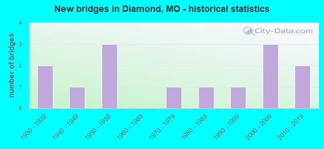
- New bridges - historical statistics
- 21930-1939
- 11940-1949
- 31950-1959
- 11970-1979
- 11980-1989
- 11990-1999
- 32000-2009
- 22010-2019


- Bridge Condition - Deck
- 18.2%Excellent
- 36.4%Very good
- 27.3%Good
- 9.1%Satisfactory
- 9.1%Fair

- Bridge Condition - Superstructure
- 18.2%Excellent
- 9.1%Very good
- 63.6%Good
- 9.1%Satisfactory

- Bridge Condition - Substructure
- 9.1%Excellent
- 27.3%Very good
- 36.4%Good
- 27.3%Satisfactory

- Bridge Condition - Channel
- 8.3%Very good
- 8.3%Good
- 66.7%Satisfactory
- 16.7%Fair
Find on map >> Show street view
Structure Number: 13636, Location: S 8 T 26 N R 31 W (Lat: 36.992297, Lng: -94.332911), Route carried "on" structure: County highway 44, Year Built: 1970, Status: Posted for load, Structure Length: 0.94m (3.08ft), Average Daily Traffic: 50 (year 2021), Truck Traffic: 10%, Average Future Daily Traffic: 78 (year 2041), Design Load: H 20, Features Intersected: CARVER BR, Facility Carried by Structure: NIGHTHAWK RD
Minimum Vertical Clearance: 30+ m (98+ ft), Kilometerpoint: 0.322, Lanes on structure: 2, Owner: County Highway Agency, Approaching Roadway Width: 6.1m (20.0ft), Material/Design: Steel, Design/Construction: Stringer/Multi-beam, Number Of Spans In Main Unit: 1, Length of Maximum Span: 9.1m (29.9ft), Curb-To-Curb Width: 5.7m (18.7ft), Out-to-Out Width: 6.1m (20.0ft)
Condition: Deck: Good, Superstructure: Good, Substructure: Good, Channel: Satisfactory, Operating Rating: 45.9 metric tons, Method Used To Determine Operating Rating: Allowable Stress (AS), Inventory Rating: 25.2 metric tons, Method Used To Determine Inventory Rating: Allowable Stress (AS), Structural Evaluation: Equal to present minimum criteria, Deck Geometry: Meets minimum limits, Waterway Adequacy: Better than present minimum criteria, Approach Roadway Alignment: Equal to present desirable criteria, Designated Inspection Frequency: Every 24 months, Inspection Date: January 2020, Deck Structure Type: Concrete Cast-file-Place, Wearing Surface/Protective System: Wearing Surface: Bituminous
Find on map >> Show street view
Structure Number: 173, Location: S 1 T 26 N R 31 W (Lat: 37.009381, Lng: -94.265492), Route carried "on" structure: County highway 148, Year Built: 1935, Status: Posted for load, Structure Length: 0.70m (2.30ft), Average Daily Traffic: 30 (year 2021), Truck Traffic: 10%, Average Future Daily Traffic: 47 (year 2041), Design Load: H 10, Features Intersected: TRIB OF JONES CR, Facility Carried by Structure: CHERRY RD
Minimum Vertical Clearance: 30+ m (98+ ft), Kilometerpoint: 1.127, Lanes on structure: 2, Owner: County Highway Agency, Approaching Roadway Width: 5.5m (18.0ft), Material/Design: Steel, Design/Construction: Stringer/Multi-beam, Number Of Spans In Main Unit: 1, Number Of Approach Spans: 1, Length of Maximum Span: 4.6m (15.1ft), Curb-To-Curb Width: 5.6m (18.4ft), Out-to-Out Width: 6.2m (20.3ft)
Condition: Deck: Good, Superstructure: Good, Substructure: Good, Channel: Satisfactory, Operating Rating: 38.7 metric tons, Method Used To Determine Operating Rating: Allowable Stress (AS), Inventory Rating: 18.9 metric tons, Method Used To Determine Inventory Rating: Allowable Stress (AS), Structural Evaluation: Somewhat better than minimum adequacy, Deck Geometry: Meets minimum limits, Waterway Adequacy: Better than present minimum criteria, Approach Roadway Alignment: Equal to present desirable criteria, Designated Inspection Frequency: Every 24 months, Inspection Date: January 2020, Deck Structure Type: Concrete Cast-file-Place, Wearing Surface/Protective System: Wearing Surface: Monolithic Concrete
Find on map >> Show street view
Structure Number: 19392, Location: S 17 T 26 N R 31 W (Lat: 36.980717, Lng: -94.333325), Route carried "on" structure: County highway 220, Year Built: 1940, Status: Posted for load, Structure Length: 1.01m (3.31ft), Average Daily Traffic: 50 (year 2021), Truck Traffic: 10%, Average Future Daily Traffic: 78 (year 2041), Design Load: H 10, Features Intersected: BAYNHAM BR, Facility Carried by Structure: NIGHTHAWK RD
Minimum Vertical Clearance: 30+ m (98+ ft), Kilometerpoint: 0.161, Lanes on structure: 2, Owner: County Highway Agency, Approaching Roadway Width: 5.5m (18.0ft), Material/Design: Concrete continuous, Design/Construction: Slab, Number Of Spans In Main Unit: 3, Length of Maximum Span: 3.4m (11.2ft), Curb-To-Curb Width: 6.9m (22.6ft), Out-to-Out Width: 7.3m (24.0ft)
Condition: Deck: Good, Superstructure: Good, Substructure: Good, Channel: Satisfactory, Operating Rating: 31.5 metric tons, Method Used To Determine Operating Rating: Allowable Stress (AS), Inventory Rating: 17.1 metric tons, Method Used To Determine Inventory Rating: Allowable Stress (AS), Structural Evaluation: Somewhat better than minimum adequacy, Deck Geometry: Somewhat better than minimum adequacy, Waterway Adequacy: Better than present minimum criteria, Approach Roadway Alignment: Equal to present desirable criteria, Designated Inspection Frequency: Every 24 months, Inspection Date: January 2020, Deck Structure Type: Concrete Cast-file-Place, Wearing Surface/Protective System: Wearing Surface: Monolithic Concrete
Find on map >> Show street view
Structure Number: 28244, Location: S 30 T 27 N R 31 W (Lat: 37.036242, Lng: -94.350236), Route carried "on" structure: County highway 39, Year Built: 1998, Status: Open, Structure Length: 0.70m (2.30ft), Average Daily Traffic: 100 (year 2021), Truck Traffic: 10%, Average Future Daily Traffic: 155 (year 2041), Design Load: HS 20, Features Intersected: TRIB OF GROVE CR, Facility Carried by Structure: CARVER RD
Minimum Vertical Clearance: 30+ m (98+ ft), Kilometerpoint: 1.931, Lanes on structure: 2, Owner: County Highway Agency, Approaching Roadway Width: 5.5m (18.0ft), Material/Design: Concrete, Design/Construction: Slab, Number Of Spans In Main Unit: 1, Length of Maximum Span: 6.1m (20.0ft), Curb-To-Curb Width: 6.8m (22.3ft), Out-to-Out Width: 6.9m (22.6ft)
Condition: Deck: Excellent, Superstructure: Excellent, Substructure: Good, Channel: Satisfactory, Operating Rating: 59.4 metric tons, Method Used To Determine Operating Rating: Load Factor (LF), Inventory Rating: 36.0 metric tons, Method Used To Determine Inventory Rating: Load Factor (LF), Structural Evaluation: Better than present minimum criteria, Deck Geometry: Somewhat better than minimum adequacy, Waterway Adequacy: Better than present minimum criteria, Approach Roadway Alignment: Equal to present desirable criteria, Designated Inspection Frequency: Every 24 months, Inspection Date: January 2020, Deck Structure Type: Concrete Precast Panels, Wearing Surface/Protective System: Wearing Surface: Bituminous
Find on map >> Show street view
Structure Number: 28485, Location: S 17 T 26 N R 31 W (Lat: 36.970089, Lng: -94.351575), Route carried "on" structure: County highway 41, Year Built: 2000, Status: Open, Structure Length: 1.55m (5.09ft), Average Daily Traffic: 100 (year 2021), Truck Traffic: 10%, Average Future Daily Traffic: 155 (year 2041), Features Intersected: BAYNHAM BR, Facility Carried by Structure: CARVER RD
Minimum Vertical Clearance: 30+ m (98+ ft), Kilometerpoint: 2.897, Lanes on structure: 2, Owner: County Highway Agency, Approaching Roadway Width: 5.5m (18.0ft), Material/Design: Steel, Design/Construction: Stringer/Multi-beam, Number Of Spans In Main Unit: 1, Length of Maximum Span: 14.6m (47.9ft), Curb-To-Curb Width: 6.1m (20.0ft), Out-to-Out Width: 6.2m (20.3ft)
Condition: Deck: Very good, Superstructure: Good, Substructure: Satisfactory, Channel: Fair, Operating Rating: 58.5 metric tons, Method Used To Determine Operating Rating: Load Factor (LF), Inventory Rating: 35.1 metric tons, Method Used To Determine Inventory Rating: Load Factor (LF), Structural Evaluation: Equal to present minimum criteria, Deck Geometry: Somewhat better than minimum adequacy, Waterway Adequacy: Better than present minimum criteria, Approach Roadway Alignment: Equal to present desirable criteria, Designated Inspection Frequency: Every 24 months, Inspection Date: January 2020, Deck Structure Type: Concrete Cast-file-Place, Wearing Surface/Protective System: Wearing Surface: Bituminous
Find on map >> Show street view
Structure Number: 287, Location: S 28 T 25 N R 32 W (Lat: 36.856719, Lng: -94.335367), Route carried "on" structure: US 60, Year Built: 1959, Year Reconstructed: 1990, Status: Open, Structure Length: 6.55m (21.49ft), Average Daily Traffic: 8,811 (year 2021), Truck Traffic: 18%, Average Future Daily Traffic: 16,300 (year 2041), Design Load: H 20, Features Intersected: HICKORY CR
Minimum Vertical Clearance: 30+ m (98+ ft), Kilometerpoint: 25.758, Lanes on structure: 2, Base Highway Network: Yes, Owner: State Highway Agency, Approaching Roadway Width: 13.4m (44.0ft), Skew: 3 degrees, Material/Design: Steel continuous, Design/Construction: Stringer/Multi-beam, Number Of Spans In Main Unit: 3, Length of Maximum Span: 24.4m (80.1ft), Curb-To-Curb Width: 9.4m (30.8ft), Out-to-Out Width: 9.6m (31.5ft)
Condition: Deck: Satisfactory, Superstructure: Satisfactory, Substructure: Satisfactory, Channel: Fair, Operating Rating: 39.6 metric tons, Method Used To Determine Operating Rating: Load Factor (LF), Inventory Rating: 23.4 metric tons, Method Used To Determine Inventory Rating: Load Factor (LF), Structural Evaluation: Somewhat better than minimum adequacy, Deck Geometry: Meets minimum limits, Waterway Adequacy: Equal to present desirable criteria, Approach Roadway Alignment: Equal to present desirable criteria, Designated Inspection Frequency: Every 24 months, Inspection Date: September 2021, Deck Structure Type: Concrete Cast-file-Place, Wearing Surface/Protective System: Wearing Surface: Low Slump Concrete
Find on map >> Show street view
Structure Number: 288, Location: S 31 T 25 N R 31 W (Lat: 36.846756, Lng: -94.368214), Route carried "on" structure: US 60, Year Built: 1959, Year Reconstructed: 1990, Status: Open, Structure Length: 6.46m (21.19ft), Average Daily Traffic: 9,793 (year 2021), Truck Traffic: 19%, Average Future Daily Traffic: 19,586 (year 2041), Design Load: H 20, Features Intersected: CST PINEVILLE RD, KCS RR
Minimum Vertical Clearance: 30+ m (98+ ft), Kilometerpoint: 22.613, Lanes on structure: 2, Lanes under structure: 2, Base Highway Network: Yes, Owner: State Highway Agency, Approaching Roadway Width: 13.4m (44.0ft), Skew: 2 degrees, Material/Design: Steel continuous, Design/Construction: Stringer/Multi-beam, Number Of Spans In Main Unit: 4, Length of Maximum Span: 18.0m (59.1ft), Curb-To-Curb Width: 9.4m (30.8ft), Out-to-Out Width: 9.6m (31.5ft)
Condition: Deck: Fair, Superstructure: Good, Substructure: Satisfactory, Operating Rating: 41.4 metric tons, Method Used To Determine Operating Rating: Load Factor (LF), Inventory Rating: 25.2 metric tons, Method Used To Determine Inventory Rating: Load Factor (LF), Structural Evaluation: Equal to present minimum criteria, Deck Geometry: Meets minimum limits, Underclear: Better than present minimum criteria, Approach Roadway Alignment: Equal to present desirable criteria, Designated Inspection Frequency: Every 24 months, Inspection Date: September 2021, Deck Structure Type: Concrete Cast-file-Place, Wearing Surface/Protective System: Wearing Surface: Low Slump Concrete
Find on map >> Show street view
Structure Number: 30212, Location: S 14 T 26 N R 31 W (Lat: 36.980181, Lng: -94.297692), Route carried "on" structure: County highway , Year Built: 2002, Status: Open, Structure Length: 0.73m (2.40ft), Average Daily Traffic: 100 (year 2021), Truck Traffic: 5%, Average Future Daily Traffic: 155 (year 2041), Features Intersected: BAYNHAM BR, Facility Carried by Structure: ELDER & PANDA RD
Minimum Vertical Clearance: 30+ m (98+ ft), Kilometerpoint: 0.000, Lanes on structure: 2, Owner: County Highway Agency, Approaching Roadway Width: 5.5m (18.0ft), Material/Design: Steel, Design/Construction: Stringer/Multi-beam, Number Of Spans In Main Unit: 1, Length of Maximum Span: 7.0m (23.0ft), Curb-To-Curb Width: 11.9m (39.0ft), Out-to-Out Width: 12.1m (39.7ft)
Condition: Deck: Very good, Superstructure: Good, Substructure: Very good, Channel: Satisfactory, Operating Rating: 90.0 metric tons, Method Used To Determine Operating Rating: Load Factor (LF), Inventory Rating: 54.0 metric tons, Method Used To Determine Inventory Rating: Load Factor (LF), Structural Evaluation: Better than present minimum criteria, Deck Geometry: Superior to present desirable criteria, Waterway Adequacy: Better than present minimum criteria, Approach Roadway Alignment: Equal to present minimum criteria, Designated Inspection Frequency: Every 24 months, Inspection Date: January 2020, Deck Structure Type: Concrete Cast-file-Place, Wearing Surface/Protective System: Wearing Surface: Monolithic Concrete
Find on map >> Show street view
Structure Number: 32455, Location: S 3 T 27 N R 31 W (Lat: 37.037389, Lng: -94.277864), Route carried "on" structure: County highway 48, Year Built: 2006, Status: Open, Structure Length: 1.52m (4.99ft), Average Daily Traffic: 60 (year 2021), Truck Traffic: 10%, Average Future Daily Traffic: 93 (year 2041), Design Load: HS 20, Features Intersected: TRIB OF JONES CR, Facility Carried by Structure: PELICAN RD
Minimum Vertical Clearance: 30+ m (98+ ft), Kilometerpoint: 1.770, Lanes on structure: 2, Owner: County Highway Agency, Approaching Roadway Width: 6.7m (22.0ft), Skew: 4 degrees, Material/Design: Steel, Design/Construction: Stringer/Multi-beam, Number Of Spans In Main Unit: 1, Length of Maximum Span: 14.3m (46.9ft), Curb-To-Curb Width: 7.3m (24.0ft), Out-to-Out Width: 7.5m (24.6ft)
Condition: Deck: Very good, Superstructure: Very good, Substructure: Very good, Channel: Good, Operating Rating: 31.5 metric tons, Method Used To Determine Operating Rating: Load Factor (LF), Inventory Rating: 18.9 metric tons, Method Used To Determine Inventory Rating: Load Factor (LF), Structural Evaluation: Somewhat better than minimum adequacy, Deck Geometry: Equal to present minimum criteria, Waterway Adequacy: Better than present minimum criteria, Approach Roadway Alignment: Equal to present desirable criteria, Designated Inspection Frequency: Every 24 months, Inspection Date: January 2020, Deck Structure Type: Concrete Cast-file-Place, Wearing Surface/Protective System: Wearing Surface: Monolithic Concrete
Find on map >> Show street view
Structure Number: 35978, Location: S 7 T 26 N R 31 W (Lat: 36.987656, Lng: -94.350950), Route carried "on" structure: County highway 41, Year Built: 2017, Status: Open, Structure Length: 0.73m (2.40ft), Average Daily Traffic: 400 (year 2021), Truck Traffic: 10%, Average Future Daily Traffic: 620 (year 2041), Design Load: HS 20, Features Intersected: CARVER BR, Facility Carried by Structure: CARVER RD
Minimum Vertical Clearance: 30+ m (98+ ft), Kilometerpoint: 0.805, Lanes on structure: 2, Owner: County Highway Agency, Approaching Roadway Width: 5.8m (19.0ft), Material/Design: Concrete, Design/Construction: Slab, Number Of Spans In Main Unit: 1, Length of Maximum Span: 7.0m (23.0ft), Curb-To-Curb Width: 7.7m (25.3ft), Out-to-Out Width: 7.8m (25.6ft)
Condition: Deck: Excellent, Superstructure: Excellent, Substructure: Excellent, Channel: Very good, Operating Rating: 81.9 metric tons, Method Used To Determine Operating Rating: Load Factor (LF), Inventory Rating: 49.5 metric tons, Method Used To Determine Inventory Rating: Load Factor (LF), Structural Evaluation: Superior to present desirable criteria, Deck Geometry: Somewhat better than minimum adequacy, Waterway Adequacy: Better than present minimum criteria, Approach Roadway Alignment: Equal to present desirable criteria, Designated Inspection Frequency: Every 24 months, Inspection Date: January 2020, Deck Structure Type: Concrete Precast Panels, Wearing Surface/Protective System: Wearing Surface: Monolithic Concrete
Find on map >> Show street view
Structure Number: 36309, Location: S 25 T 27 N R 31 W (Lat: 37.038533, Lng: -94.275261), Route carried "on" structure: County highway 107, Year Built: 2018, Status: Open, Structure Length: 1.86m (6.10ft), Average Daily Traffic: 200 (year 2020), Truck Traffic: 10%, Average Future Daily Traffic: 310 (year 2040), Design Load: HS 20, Features Intersected: TRIB OF JONES CR, Facility Carried by Structure: ASPEN RD
Minimum Vertical Clearance: 30+ m (98+ ft), Kilometerpoint: 0.322, Lanes on structure: 2, Owner: County Highway Agency, Approaching Roadway Width: 5.7m (18.7ft), Skew: 3 degrees, Material/Design: Steel, Design/Construction: Stringer/Multi-beam, Number Of Spans In Main Unit: 1, Length of Maximum Span: 17.6m (57.7ft), Curb-To-Curb Width: 7.4m (24.3ft), Out-to-Out Width: 7.6m (24.9ft)
Condition: Deck: Very good, Superstructure: Good, Substructure: Very good, Channel: Satisfactory, Operating Rating: 54.0 metric tons, Method Used To Determine Operating Rating: Load Factor (LF), Inventory Rating: 32.4 metric tons, Method Used To Determine Inventory Rating: Load Factor (LF), Structural Evaluation: Better than present minimum criteria, Deck Geometry: Somewhat better than minimum adequacy, Waterway Adequacy: Equal to present desirable criteria, Approach Roadway Alignment: Equal to present desirable criteria, Designated Inspection Frequency: Every 24 months, Inspection Date: January 2020, Deck Structure Type: Concrete Cast-file-Place, Wearing Surface/Protective System: Wearing Surface: Monolithic Concrete
Find on map >> Show street view
Structure Number: 3942, Location: S 15 T 26 N R 31 W (Lat: 36.978608, Lng: -94.315444), Route carried "on" structure: State highway 59, Year Built: 1988, Status: Open, Structure Length: 1.05m (3.44ft), Average Daily Traffic: 10,809 (year 2021), Truck Traffic: 19%, Average Future Daily Traffic: 21,618 (year 2041), Design Load: HS 20, Features Intersected: BAYNHAM BR
Minimum Vertical Clearance: 30+ m (98+ ft), Kilometerpoint: 11.822, Lanes on structure: 2, Base Highway Network: Yes, Owner: State Highway Agency, Approaching Roadway Width: 13.4m (44.0ft), Material/Design: Concrete continuous, Design/Construction: Culvert, Number Of Spans In Main Unit: 3, Length of Maximum Span: 3.4m (11.2ft), Curb-To-Curb Width: 14.6m (47.9ft), Out-to-Out Width: 24.4m (80.1ft)
Condition: Channel: Satisfactory, Culverts: Satisfactory, Operating Rating: 70.2 metric tons, Method Used To Determine Operating Rating: Load Factor (LF), Inventory Rating: 42.3 metric tons, Method Used To Determine Inventory Rating: Load Factor (LF), Structural Evaluation: Equal to present minimum criteria, Deck Geometry: Superior to present desirable criteria, Waterway Adequacy: Superior to present desirable criteria, Approach Roadway Alignment: Equal to present desirable criteria, Designated Inspection Frequency: Every 24 months, Inspection Date: Febuary 2022
Find on map >> Show street view
Structure Number: 5398, Location: S 15 T 26 N R 31 W (Lat: 36.968139, Lng: -94.315817), Route carried "on" structure: State highway 59, Year Built: 1930, Status: Open, Structure Length: 0.71m (2.33ft), Average Daily Traffic: 10,809 (year 2021), Truck Traffic: 19%, Average Future Daily Traffic: 21,618 (year 2041), Design Load: H 15, Features Intersected: DRY BR
Minimum Vertical Clearance: 30+ m (98+ ft), Kilometerpoint: 12.987, Lanes on structure: 2, Base Highway Network: Yes, Owner: State Highway Agency, Approaching Roadway Width: 12.2m (40.0ft), Skew: 2 degrees, Material/Design: Concrete continuous, Design/Construction: Culvert, Number Of Spans In Main Unit: 2, Length of Maximum Span: 3.0m (9.8ft)
Condition: Channel: Satisfactory, Culverts: Satisfactory, Operating Rating: 55.8 metric tons, Method Used To Determine Operating Rating: Load Factor (LF), Inventory Rating: 33.3 metric tons, Method Used To Determine Inventory Rating: Load Factor (LF), Structural Evaluation: Equal to present minimum criteria, Waterway Adequacy: Equal to present desirable criteria, Approach Roadway Alignment: Equal to present desirable criteria, Designated Inspection Frequency: Every 24 months, Inspection Date: Febuary 2022
Find on map >> Show street view
Structure Number: 288, Location: S 31 T 25 N R 31 W (Lat: 36.846756, Lng: -94.368214), Route carried "under" structure: City street , Year Built: 1959, Structure Length: 0. m, Average Daily Traffic: 1,740 (year 2021), Truck Traffic: 4%, Features Intersected: CST PINEVILLE RD, Facility Carried by Structure: US 60 E
Minimum Vertical Clearance: 5.11m (16.77ft), Kilometerpoint: 1.362, Lanes on structure: 2, Lanes under structure: 2, Material/Design: Steel continuous, Design/Construction: Stringer/Multi-beam, Length of Maximum Span: 18.0m (59.1ft)