Bridge Statistics for Dickens, Iowa (IA)
Condition, Traffic, Stress, Structural Evaluation, Project Costs
- National Bridge Inventory (NBI) Statistics
- 15Number of bridges
- 128ft / 39.1mTotal length
- 9,145Total average daily traffic
- 1,374Total average daily truck traffic
- 9,145Total future (year 2039) average daily traffic
- National Bridge Inventory (NBI) Registered Bridges for Dickens
- No street view available for this location
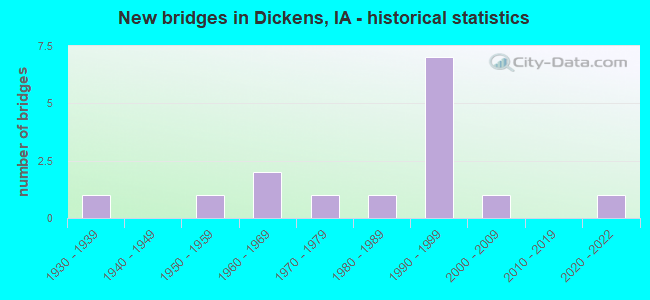
- New bridges - historical statistics
- 11930-1939
- 11950-1959
- 21960-1969
- 11970-1979
- 11980-1989
- 71990-1999
- 12000-2009
- 12020-2022

- Reconstructed bridges - Historical Statistics
- 11960-1969
- 01970-1979
- 11980-1989


- Bridge Condition - Deck
- 12.5%Very good
- 12.5%Good
- 25.0%Satisfactory
- 37.5%Fair
- 12.5%Poor

- Bridge Condition - Superstructure
- 12.5%Very good
- 12.5%Good
- 25.0%Satisfactory
- 37.5%Fair
- 12.5%Poor

- Bridge Condition - Substructure
- 12.5%Very good
- 37.5%Good
- 37.5%Fair
- 12.5%Poor

- Bridge Condition - Channel
- 6.7%Very good
- 40.0%Good
- 46.7%Satisfactory
- 6.7%Fair

- Bridge Condition - Culverts
- 14.3%Good
- 85.7%Satisfactory
Find on map >> Show street view
Structure Number: 2036, Location: 1.0 mi. E of jct. SR M54 (Lat: 43.126819, Lng: -95.014264), Route carried "on" structure: US 18, Year Built: 1931, Year Reconstructed: 1965, Status: Open, Structure Length: 3.20m (10.50ft), Average Daily Traffic: 3,850 (year 2020), Truck Traffic: 16%, Average Future Daily Traffic: 3,850 (year 2040), Design Load: H 20, Features Intersected: LOST ISLAND OUTLET
Minimum Vertical Clearance: 30+ m (98+ ft), Kilometerpoint: 142.169, Lanes on structure: 2, Base Highway Network: Yes, Owner: State Highway Agency, Approaching Roadway Width: 13.4m (44.0ft), Skew: 5 degrees, Material/Design: Concrete continuous, Design/Construction: Slab, Number Of Spans In Main Unit: 3, Length of Maximum Span: 12.2m (40.0ft), Curb-To-Curb Width: 9.1m (29.9ft), Out-to-Out Width: 11.0m (36.1ft)
Condition: Deck: Fair, Superstructure: Fair, Substructure: Fair, Channel: Very good, Operating Rating: 49.9 metric tons, Method Used To Determine Operating Rating: Allowable Stress (AS), Inventory Rating: 28.1 metric tons, Method Used To Determine Inventory Rating: Allowable Stress (AS), Structural Evaluation: Somewhat better than minimum adequacy, Deck Geometry: Meets minimum limits, Waterway Adequacy: Better than present minimum criteria, Approach Roadway Alignment: Equal to present desirable criteria, Designated Inspection Frequency: Every 24 months, Inspection Date: October 2020, Deck Structure Type: Concrete Cast-file-Place, Wearing Surface/Protective System: Wearing Surface: Low Slump Concrete
Find on map >> Show street view
Structure Number: 2038, Location: At the jct of SR N14 (Lat: 43.126594, Lng: -94.972681), Route carried "on" structure: US 18, Year Built: 1965, Year Reconstructed: 1994, Status: Open, Structure Length: 0.88m (2.89ft), Average Daily Traffic: 3,850 (year 2020), Truck Traffic: 16%, Average Future Daily Traffic: 3,850 (year 2041), Design Load: HS 20, Features Intersected: DRAINAGE DITCH
Minimum Vertical Clearance: 30+ m (98+ ft), Kilometerpoint: 145.554, Lanes on structure: 2, Base Highway Network: Yes, Owner: State Highway Agency, Approaching Roadway Width: 13.4m (44.0ft), Skew: 4 degrees, Material/Design: Concrete continuous, Design/Construction: Culvert, Number Of Spans In Main Unit: 2, Length of Maximum Span: 4.3m (14.1ft)
Condition: Channel: Good, Culverts: Satisfactory, Operating Rating: 44.0 metric tons, Method Used To Determine Operating Rating: Field evaluation and documented engineering judgment, Inventory Rating: 32.7 metric tons, Method Used To Determine Inventory Rating: Field evaluation and documented engineering judgment, Structural Evaluation: Equal to present minimum criteria, Waterway Adequacy: Equal to present minimum criteria, Approach Roadway Alignment: Equal to present desirable criteria, Designated Inspection Frequency: Every 24 months, Inspection Date: December 2021
Find on map >> Show street view
Structure Number: 116151, Location: 095360201 (Lat: 43.083614, Lng: -95.067194), Route carried "on" structure: County highway , Year Built: 1986, Status: Open, Structure Length: 12.74m (41.80ft), Average Daily Traffic: 40 (year 2019), Average Future Daily Traffic: 40 (year 2039), Design Load: H 20, Features Intersected: LITTLE SIOUX RIVER, Facility Carried by Structure: FM 390TH ST
Minimum Vertical Clearance: 30+ m (98+ ft), Kilometerpoint: 24.518, Lanes on structure: 2, Owner: County Highway Agency, Approaching Roadway Width: 10.4m (34.1ft), Material/Design: Prestressed concrete continuous, Design/Construction: Stringer/Multi-beam, Number Of Spans In Main Unit: 5, Length of Maximum Span: 27.1m (88.9ft), Curb or Sidewalk Widths: Left: 0.3m (1.0ft), Right: 0.3m (1.0ft), Curb-To-Curb Width: 9.1m (29.9ft), Out-to-Out Width: 9.8m (32.2ft)
Condition: Deck: Satisfactory, Superstructure: Satisfactory, Substructure: Good, Channel: Satisfactory, Operating Rating: 62.9 metric tons, Method Used To Determine Operating Rating: Load Factor (LF) rating reported by rating factor (RF) method using MS18 loading, Inventory Rating: 37.6 metric tons, Method Used To Determine Inventory Rating: Load Factor (LF) rating reported by rating factor (RF) method using MS18 loading, Structural Evaluation: Equal to present minimum criteria, Deck Geometry: Better than present minimum criteria, Waterway Adequacy: Equal to present desirable criteria, Approach Roadway Alignment: Equal to present desirable criteria, Designated Inspection Frequency: Every 48 months, Inspection Date: March 2019, Deck Structure Type: Concrete Cast-file-Place, Wearing Surface/Protective System: Wearing Surface: Monolithic Concrete
Find on map >> Show street view
Structure Number: 11616, Location: 095360201 (Lat: 43.083603, Lng: -95.056192), Route carried "on" structure: County highway , Year Built: 1955, Status: Open, Structure Length: 3.90m (12.80ft), Average Daily Traffic: 40 (year 2019), Average Future Daily Traffic: 40 (year 2041), Design Load: H 15, Features Intersected: OVERFLOW LITTLE SIOUX R, Facility Carried by Structure: 390TH ST
Minimum Vertical Clearance: 30+ m (98+ ft), Kilometerpoint: 25.413, Lanes on structure: 2, Owner: County Highway Agency, Approaching Roadway Width: 8.5m (27.9ft), Material/Design: Steel continuous, Design/Construction: Stringer/Multi-beam, Number Of Spans In Main Unit: 3, Length of Maximum Span: 14.9m (48.9ft), Curb-To-Curb Width: 6.2m (20.3ft), Out-to-Out Width: 6.8m (22.3ft)
Condition: Deck: Fair, Superstructure: Fair, Substructure: Fair, Channel: Fair, Operating Rating: 37.9 metric tons, Method Used To Determine Operating Rating: Load Factor (LF) rating reported by rating factor (RF) method using MS18 loading, Inventory Rating: 22.7 metric tons, Method Used To Determine Inventory Rating: Load Factor (LF) rating reported by rating factor (RF) method using MS18 loading, Structural Evaluation: Somewhat better than minimum adequacy, Deck Geometry: Somewhat better than minimum adequacy, Waterway Adequacy: Equal to present desirable criteria, Approach Roadway Alignment: Equal to present minimum criteria, Length Of Structure Improvement: 7.20m (23.62ft), Designated Inspection Frequency: Every 24 months, Inspection Date: March 2021, Bridge Improvement Cost: $72,000, Roadway Improvement Cost: $7,000, Deck Structure Type: Concrete Cast-file-Place, Wearing Surface/Protective System: Wearing Surface: Monolithic Concrete
Find on map >> Show street view
Structure Number: 116481, Location: 096350701 (Lat: 43.155672, Lng: -95.021275), Route carried "on" structure: County highway , Year Built: 1991, Status: Open, Structure Length: 2.29m (7.51ft), Average Daily Traffic: 45 (year 2015), Average Future Daily Traffic: 45 (year 2039), Design Load: HS 20, Features Intersected: PICKEREL RUN, Facility Carried by Structure: 340TH ST
Minimum Vertical Clearance: 30+ m (98+ ft), Kilometerpoint: 19.964, Lanes on structure: 2, Owner: County Highway Agency, Approaching Roadway Width: 7.9m (25.9ft), Material/Design: Concrete continuous, Design/Construction: Slab, Number Of Spans In Main Unit: 3, Length of Maximum Span: 8.8m (28.9ft), Curb-To-Curb Width: 9.3m (30.5ft), Out-to-Out Width: 10.1m (33.1ft)
Condition: Deck: Good, Superstructure: Good, Substructure: Good, Channel: Satisfactory, Operating Rating: 76.3 metric tons, Method Used To Determine Operating Rating: Allowable Stress (AS), Inventory Rating: 45.7 metric tons, Method Used To Determine Inventory Rating: Allowable Stress (AS), Structural Evaluation: Better than present minimum criteria, Deck Geometry: Better than present minimum criteria, Waterway Adequacy: Equal to present desirable criteria, Approach Roadway Alignment: Equal to present desirable criteria, Designated Inspection Frequency: Every 48 months, Inspection Date: March 2019, Deck Structure Type: Concrete Cast-file-Place, Wearing Surface/Protective System: Wearing Surface: Monolithic Concrete
Find on map >> Show street view
Structure Number: 116501, Location: 096351704 (Lat: 43.135769, Lng: -95.011772), Route carried "on" structure: County highway , Year Built: 1990, Status: Open, Structure Length: 0.82m (2.69ft), Average Daily Traffic: 120 (year 2019), Average Future Daily Traffic: 120 (year 2039), Design Load: HS 20, Features Intersected: PICKEREL RUN, Facility Carried by Structure: FM 280TH AVE
Minimum Vertical Clearance: 30+ m (98+ ft), Kilometerpoint: 20.641, Lanes on structure: 2, Owner: County Highway Agency, Approaching Roadway Width: 9.4m (30.8ft), Material/Design: Concrete, Design/Construction: Culvert, Number Of Spans In Main Unit: 2, Length of Maximum Span: 3.7m (12.1ft)
Condition: Channel: Satisfactory, Culverts: Satisfactory, Operating Rating: 55.1 metric tons, Method Used To Determine Operating Rating: Load Factor (LF) rating reported by rating factor (RF) method using MS18 loading, Inventory Rating: 33.0 metric tons, Method Used To Determine Inventory Rating: Load Factor (LF) rating reported by rating factor (RF) method using MS18 loading, Structural Evaluation: Equal to present minimum criteria, Waterway Adequacy: Equal to present desirable criteria, Approach Roadway Alignment: Better than present minimum criteria, Designated Inspection Frequency: Every 48 months, Inspection Date: March 2019
Find on map >> Show street view
Structure Number: 116511, Location: 096351902 (Lat: 43.118458, Lng: -95.033078), Route carried "on" structure: County highway , Year Built: 1993, Status: Open, Structure Length: 3.90m (12.80ft), Average Daily Traffic: 460 (year 2019), Truck Traffic: 13%, Average Future Daily Traffic: 460 (year 2041), Design Load: HS 20, Features Intersected: PICKERAL RUN, Facility Carried by Structure: FM 280TH AVE
Minimum Vertical Clearance: 30+ m (98+ ft), Kilometerpoint: 20.796, Lanes on structure: 2, Owner: County Highway Agency, Approaching Roadway Width: 8.5m (27.9ft), Material/Design: Concrete continuous, Design/Construction: Slab, Number Of Spans In Main Unit: 3, Length of Maximum Span: 14.9m (48.9ft), Curb or Sidewalk Widths: Left: 0.3m (1.0ft), Right: 0.3m (1.0ft), Curb-To-Curb Width: 9.3m (30.5ft), Out-to-Out Width: 10.1m (33.1ft)
Condition: Deck: Poor, Superstructure: Poor, Substructure: Fair, Channel: Satisfactory, Operating Rating: 88.5 metric tons, Method Used To Determine Operating Rating: Load Factor (LF), Inventory Rating: 52.9 metric tons, Method Used To Determine Inventory Rating: Load Factor (LF), Structural Evaluation: Meets minimum limits, Deck Geometry: Equal to present minimum criteria, Waterway Adequacy: Equal to present desirable criteria, Approach Roadway Alignment: Equal to present desirable criteria, Designated Inspection Frequency: Every 24 months, Inspection Date: March 2021, Deck Structure Type: Concrete Cast-file-Place, Wearing Surface/Protective System: Wearing Surface: Monolithic Concrete
Find on map >> Show street view
Structure Number: 116521, Location: 096352002 (Lat: 43.118711, Lng: -95.011631), Route carried "on" structure: County highway , Year Built: 1994, Status: Open, Structure Length: 0.64m (2.10ft), Average Daily Traffic: 100 (year 2015), Average Future Daily Traffic: 100 (year 2041), Design Load: HS 20, Features Intersected: STREAM, Facility Carried by Structure: 290TH AVE
Minimum Vertical Clearance: 30+ m (98+ ft), Kilometerpoint: 19.595, Lanes on structure: 2, Owner: County Highway Agency, Approaching Roadway Width: 9.4m (30.8ft), Skew: 4 degrees, Material/Design: Concrete continuous, Design/Construction: Culvert, Number Of Spans In Main Unit: 2, Length of Maximum Span: 2.4m (7.9ft)
Condition: Channel: Satisfactory, Culverts: Satisfactory, Inventory Rating: 32.3 metric tons, Method Used To Determine Inventory Rating: Field evaluation and documented engineering judgment, Structural Evaluation: Equal to present minimum criteria, Waterway Adequacy: Equal to present desirable criteria, Approach Roadway Alignment: Equal to present desirable criteria, Designated Inspection Frequency: Every 24 months, Inspection Date: March 2021
Find on map >> Show street view
Structure Number: 116531, Location: 096352102 (Lat: 43.117281, Lng: -94.991986), Route carried "on" structure: County highway , Year Built: 1999, Status: Open, Structure Length: 0.70m (2.30ft), Average Daily Traffic: 45 (year 2015), Average Future Daily Traffic: 45 (year 2039), Design Load: HS 20, Features Intersected: STREAM, Facility Carried by Structure: 300TH AVE
Minimum Vertical Clearance: 30+ m (98+ ft), Kilometerpoint: 21.459, Lanes on structure: 2, Owner: County Highway Agency, Approaching Roadway Width: 9.4m (30.8ft), Material/Design: Concrete continuous, Design/Construction: Culvert, Number Of Spans In Main Unit: 2, Length of Maximum Span: 3.0m (9.8ft)
Condition: Channel: Satisfactory, Culverts: Satisfactory, Operating Rating: 56.1 metric tons, Method Used To Determine Operating Rating: Load and Resistance Factor Rating (LRFR) rating reported by rating factor(RF) method using HL-93 loadings, Inventory Rating: 33.7 metric tons, Method Used To Determine Inventory Rating: Load and Resistance Factor Rating (LRFR) rating reported by rating factor(RF) method using HL-93 loadings, Structural Evaluation: Equal to present minimum criteria, Waterway Adequacy: Equal to present desirable criteria, Approach Roadway Alignment: Equal to present desirable criteria, Designated Inspection Frequency: Every 48 months, Inspection Date: March 2019
Find on map >> Show street view
Structure Number: 11655, Location: 096352202 (Lat: 43.118525, Lng: -94.972381), Route carried "on" structure: County highway , Year Built: 1967, Status: Open, Structure Length: 2.29m (7.51ft), Average Daily Traffic: 260 (year 2019), Truck Traffic: 32%, Average Future Daily Traffic: 260 (year 2041), Design Load: H 20, Features Intersected: DITCH NO.60, Facility Carried by Structure: FM 310TH AVE
Minimum Vertical Clearance: 30+ m (98+ ft), Kilometerpoint: 23.197, Lanes on structure: 2, Owner: County Highway Agency, Approaching Roadway Width: 11.6m (38.1ft), Material/Design: Concrete continuous, Design/Construction: Slab, Number Of Spans In Main Unit: 3, Length of Maximum Span: 8.8m (28.9ft), Curb or Sidewalk Widths: Left: 0.3m (1.0ft), Right: 0.3m (1.0ft), Curb-To-Curb Width: 8.5m (27.9ft), Out-to-Out Width: 9.1m (29.9ft)
Condition: Deck: Fair, Superstructure: Fair, Substructure: Poor, Channel: Satisfactory, Operating Rating: 46.2 metric tons, Method Used To Determine Operating Rating: Allowable Stress (AS), Inventory Rating: 26.6 metric tons, Method Used To Determine Inventory Rating: Allowable Stress (AS), Structural Evaluation: Meets minimum limits, Deck Geometry: Equal to present minimum criteria, Waterway Adequacy: Equal to present desirable criteria, Approach Roadway Alignment: Equal to present minimum criteria, Designated Inspection Frequency: Every 24 months, Inspection Date: March 2021, Deck Structure Type: Concrete Cast-file-Place, Wearing Surface/Protective System: Wearing Surface: Monolithic Concrete
Find on map >> Show street view
Structure Number: 116581, Location: 096352701 (Lat: 43.112183, Lng: -94.968575), Route carried "on" structure: County highway , Year Built: 1998, Status: Open, Structure Length: 0.70m (2.30ft), Average Daily Traffic: 40 (year 2015), Average Future Daily Traffic: 40 (year 2041), Design Load: HS 20+Mod, Features Intersected: STREAM, Facility Carried by Structure: 370TH ST
Minimum Vertical Clearance: 30+ m (98+ ft), Kilometerpoint: 25.679, Lanes on structure: 2, Owner: County Highway Agency, Approaching Roadway Width: 9.4m (30.8ft), Skew: 1 degrees, Material/Design: Concrete continuous, Design/Construction: Culvert, Number Of Spans In Main Unit: 2, Length of Maximum Span: 3.0m (9.8ft), Out-to-Out Width: 8.9m (29.2ft)
Condition: Channel: Good, Culverts: Good, Operating Rating: 56.1 metric tons, Method Used To Determine Operating Rating: Load Factor (LF) rating reported by rating factor (RF) method using MS18 loading, Inventory Rating: 33.7 metric tons, Method Used To Determine Inventory Rating: Load Factor (LF) rating reported by rating factor (RF) method using MS18 loading, Structural Evaluation: Better than present minimum criteria, Waterway Adequacy: Equal to present desirable criteria, Approach Roadway Alignment: Equal to present desirable criteria, Designated Inspection Frequency: Every 48 months, Inspection Date: March 2021
Find on map >> Show street view
Structure Number: 117291, Location: 097353202 (Lat: 43.180964, Lng: -95.015147), Route carried "on" structure: County highway , Year Built: 1995, Status: Open, Structure Length: 0.70m (2.30ft), Average Daily Traffic: 50 (year 2019), Average Future Daily Traffic: 50 (year 2041), Design Load: HS 20, Features Intersected: PICKERAL RUN #37, Facility Carried by Structure: FM 290TH AVE
Minimum Vertical Clearance: 30+ m (98+ ft), Kilometerpoint: 25.680, Lanes on structure: 2, Owner: County Highway Agency, Approaching Roadway Width: 9.4m (30.8ft), Skew: 1 degrees, Material/Design: Concrete continuous, Design/Construction: Culvert, Number Of Spans In Main Unit: 2, Length of Maximum Span: 3.0m (9.8ft)
Condition: Channel: Good, Culverts: Satisfactory, Operating Rating: 59.9 metric tons, Method Used To Determine Operating Rating: Load Factor (LF) rating reported by rating factor (RF) method using MS18 loading, Inventory Rating: 36.0 metric tons, Method Used To Determine Inventory Rating: Load Factor (LF) rating reported by rating factor (RF) method using MS18 loading, Structural Evaluation: Equal to present minimum criteria, Waterway Adequacy: Equal to present desirable criteria, Approach Roadway Alignment: Equal to present desirable criteria, Designated Inspection Frequency: Every 48 months, Inspection Date: March 2021
Find on map >> Show street view
Structure Number: 117301, Location: 097353301 (Lat: 43.184367, Lng: -94.991344), Route carried "on" structure: County highway , Year Built: 1978, Status: Open, Structure Length: 2.29m (7.51ft), Average Daily Traffic: 35 (year 2019), Average Future Daily Traffic: 35 (year 2039), Design Load: H 20, Features Intersected: DRAINAGE DIST #37 DITCH, Facility Carried by Structure: FM 320TH ST
Minimum Vertical Clearance: 30+ m (98+ ft), Kilometerpoint: 13.082, Lanes on structure: 2, Owner: County Highway Agency, Approaching Roadway Width: 11.0m (36.1ft), Material/Design: Concrete continuous, Design/Construction: Slab, Number Of Spans In Main Unit: 3, Length of Maximum Span: 8.8m (28.9ft), Curb or Sidewalk Widths: Left: 0.3m (1.0ft), Right: 0.3m (1.0ft), Curb-To-Curb Width: 9.1m (29.9ft), Out-to-Out Width: 9.8m (32.2ft)
Condition: Deck: Satisfactory, Superstructure: Satisfactory, Substructure: Good, Channel: Good, Operating Rating: 52.4 metric tons, Method Used To Determine Operating Rating: Allowable Stress (AS), Inventory Rating: 33.0 metric tons, Method Used To Determine Inventory Rating: Allowable Stress (AS), Structural Evaluation: Equal to present minimum criteria, Deck Geometry: Better than present minimum criteria, Waterway Adequacy: Equal to present desirable criteria, Approach Roadway Alignment: Equal to present desirable criteria, Designated Inspection Frequency: Every 48 months, Inspection Date: March 2019, Deck Structure Type: Concrete Cast-file-Place, Wearing Surface/Protective System: Wearing Surface: Monolithic Concrete
Find on map >> Show street view
Structure Number: 117311, Location: 097353302 (Lat: 43.182522, Lng: -94.993961), Route carried "on" structure: County highway , Year Built: 2000, Status: Open, Structure Length: 0.73m (2.40ft), Average Daily Traffic: 10 (year 2015), Average Future Daily Traffic: 10 (year 2041), Design Load: HS 20, Features Intersected: STREAM, Facility Carried by Structure: 300TH AVE
Minimum Vertical Clearance: 30+ m (98+ ft), Kilometerpoint: 28.716, Lanes on structure: 2, Owner: County Highway Agency, Approaching Roadway Width: 9.4m (30.8ft), Skew: 2 degrees, Material/Design: Concrete continuous, Design/Construction: Culvert, Number Of Spans In Main Unit: 2, Length of Maximum Span: 3.0m (9.8ft)
Condition: Channel: Good, Culverts: Satisfactory, Operating Rating: 58.0 metric tons, Method Used To Determine Operating Rating: Load Factor (LF) rating reported by rating factor (RF) method using MS18 loading, Inventory Rating: 34.7 metric tons, Method Used To Determine Inventory Rating: Load Factor (LF) rating reported by rating factor (RF) method using MS18 loading, Structural Evaluation: Equal to present minimum criteria, Waterway Adequacy: Equal to present desirable criteria, Approach Roadway Alignment: Equal to present desirable criteria, Designated Inspection Frequency: Every 48 months, Inspection Date: March 2021
Find on map >> Show street view
Structure Number: 501151, Location: 86351803 (Lat: 43.127550, Lng: -95.012553), Route carried "on" structure: City street , Year Built: 2021, Status: Open, Structure Length: 3.35m (10.99ft), Average Daily Traffic: 200 (year 2007), Average Future Daily Traffic: 200 (year 2041), Design Load: HL 93, Features Intersected: PICKERAL RUN, Facility Carried by Structure: 1ST ST SOUTH
Minimum Vertical Clearance: 30+ m (98+ ft), Kilometerpoint: 0.975, Lanes on structure: 2, Owner: City or Municipal Highway Agency, Maintenance Responsibility: County Highway Agency, Approaching Roadway Width: 10.1m (33.1ft), Material/Design: Concrete continuous, Design/Construction: Slab, Number Of Spans In Main Unit: 3, Length of Maximum Span: 13.1m (43.0ft), Curb-To-Curb Width: 9.3m (30.5ft), Out-to-Out Width: 10.1m (33.1ft)
Condition: Deck: Very good, Superstructure: Very good, Substructure: Very good, Channel: Good, Operating Rating: 66.1 metric tons, Method Used To Determine Operating Rating: Load and Resistance Factor Rating (LRFR) rating reported by rating factor(RF) method using HL-93 loadings, Inventory Rating: 39.5 metric tons, Method Used To Determine Inventory Rating: Load and Resistance Factor Rating (LRFR) rating reported by rating factor(RF) method using HL-93 loadings, Structural Evaluation: Equal to present desirable criteria, Deck Geometry: Equal to present minimum criteria, Waterway Adequacy: Equal to present desirable criteria, Approach Roadway Alignment: Equal to present desirable criteria, Designated Inspection Frequency: Every 24 months, Inspection Date: April 2021, Deck Structure Type: Concrete Cast-file-Place